Conway County, Arkansas
Conway County is a county located in the U.S. state of Arkansas. Created as Arkansas's 11th county on October 20, 1825, Conway County has four incorporated municipalities, including Morrilton, the county seat and most populous city. The county is also the site of numerous unincorporated communities and ghost towns. The county is named for Henry Wharton Conway, a politician from a powerful political family who served as the delegate from the Arkansas Territory to the U.S. Congress from 1823 to 1827.
Conway County | |
|---|---|
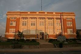 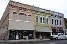 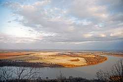 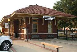 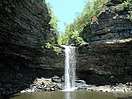 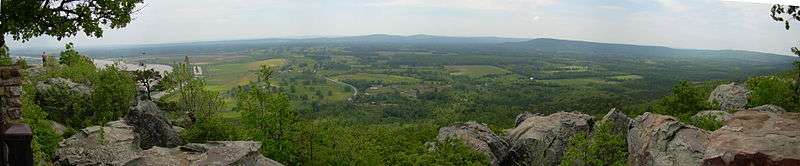 Clockwise from top: Conway County Courthouse, the Arkansas River, Cedar Falls, a panoramic view of the Arkansas River Valley from Petit Jean State Park, the Morrilton Train Station, and downtown Morrilton | |
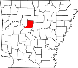 Location within the U.S. state of Arkansas | |
 Arkansas's location within the U.S. | |
| Coordinates: 35°16′00″N 92°42′00″W | |
| Country | |
| State | |
| Founded | October 20, 1825 |
| Named for | Henry Wharton Conway |
| Seat | Morrilton |
| Largest city | Morrilton |
| Area | |
| • Total | 566.66 sq mi (1,467.6 km2) |
| • Land | 556.15 sq mi (1,440.4 km2) |
| • Water | 10.51 sq mi (27.2 km2) 1.8%% |
| Population (2010) | |
| • Total | 21,273 |
| • Density | 37.5/sq mi (14.5/km2) |
| Time zone | UTC−6 (Central) |
| • Summer (DST) | UTC−5 (CDT) |
| Congressional district | 2nd |
| Website | conwaycountyar |
As of the 2010 census, the population was 21,273.[1] The county seat is Morrilton.[2] The county was formed on October 20, 1825, from a portion of Pulaski County and named for Henry Wharton Conway who was the territorial delegate to the U.S. Congress.
In 2010, the center of population of Arkansas was located in Conway County, near the city of Plumerville.[3]
History
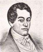
Conway County was formed on October 20, 1825 from a portion of Pulaski County and named for Henry Wharton Conway, who was the territorial delegate to the U.S. Congress.
From 1831 until 1883, Lewisburg was the county seat. When the Little Rock and Fort Smith Railroad planned built tracks 1 mile (1.6 km) north of Lewisburg in 1871, the proposed depot was to be named Morrilton after farmer E. J. Morrill, who sold the land to the railroad. People relocated from Lewisburg to Morrilton beginning in 1880, county government was relocated in 1883, and the depot was built in 1910.[4]
Conway County was much larger upon creation. Van Buren County was created from parts of Conway, Izard, and Independence counties on November 11, 1833. Perry County was created from Conway County on December 18, 1840. Faulkner County was created from parts of Conway and Pulaski counties on April 12, 1873.
Geography
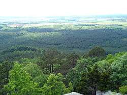
Bottom: Arkansas River winds through an alluvial plain
Conway County is within the Arkansas River Valley region, a fertile, low-lying valley along the Arkansas River between the Ozark Mountains to the north and the Ouachita Mountains to the south.
According to the U.S. Census Bureau, the county has a total area of 567 square miles (1,470 km2), of which 552 square miles (1,430 km2) is land and 14 square miles (36 km2) (2.5%) is water.[5] It is the fifth-smallest county in Arkansas by area.
The county is located approximately 52 miles (84 km) northwest of Little Rock, 109 miles (175 km) east of Fort Smith, and 180 miles (290 km) west of Memphis, Tennessee.[Note 1] Conway County is surrounded by two Central Arkansas counties: Faulkner County to the east and Perry County to the south, and three River Valley/mountain counties: Van Buren County to the north, Yell County to the southwest, and Pope County to the west.
Hydrology
Protected areas
The northern 16 square kilometres (1,600 hectares) of Conway County is protected within the Ozark National Forest, a small part of a large protected forest spanning parts of 16 Arkansas counties. Petit Jean State Park, is Arkansas's oldest state park, rises from the River Valley in southern Conway County along the top of Petit Jean Mountain.
Conway County is home to five Wildlife Management Areas (WMAs) under Arkansas Game and Fish Commission jurisdiction. Ed Gordon Point Remove WMA is a wetland near the confluence of the East Fork and West Fork of Point Remove Creek in western Conway County. The area is known for duck, deer, and dove hunting.[7] Lake Overcup WMA is a noted crappie fishing lake created by AGFC in 1963.[8] Cypress Creek WMA is located around the shore of Brewer Lake, a fishing lake built in 1983 to construct a water supply for Conway,[9] as well as containing parts of the Cherokee WMA[10] and a small part of Piney Creeks WMA.[11] The county is also home to the Cove Creek Natural Area.
Demographics
| Historical population | |||
|---|---|---|---|
| Census | Pop. | %± | |
| 1830 | 982 | — | |
| 1840 | 2,892 | 194.5% | |
| 1850 | 3,583 | 23.9% | |
| 1860 | 6,697 | 86.9% | |
| 1870 | 8,112 | 21.1% | |
| 1880 | 12,755 | 57.2% | |
| 1890 | 19,459 | 52.6% | |
| 1900 | 19,772 | 1.6% | |
| 1910 | 22,729 | 15.0% | |
| 1920 | 22,578 | −0.7% | |
| 1930 | 21,949 | −2.8% | |
| 1940 | 21,536 | −1.9% | |
| 1950 | 18,137 | −15.8% | |
| 1960 | 15,430 | −14.9% | |
| 1970 | 16,805 | 8.9% | |
| 1980 | 19,505 | 16.1% | |
| 1990 | 19,151 | −1.8% | |
| 2000 | 20,336 | 6.2% | |
| 2010 | 21,273 | 4.6% | |
| Est. 2019 | 20,846 | [12] | −2.0% |
| U.S. Decennial Census[13] 1790–1960[14] 1900–1990[15] 1990–2000[16] 2010–2016[1] | |||
2010 Census
Racial/Ethnic Makeup of Conway County treating Hispanics as a Separate Category (2010)[17]
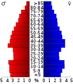
As of the 2010 census,[17] there were 21,273 people, 8,463 households, and 4,473 families in the county. The population density was 38 people per square mile (14/km²). There were 9,720 housing units at an average density of 17 per square mile (7/km²). The racial makeup of the county was 84.2% White, 11.2% Black or African American, 0.7% Native American, 0.4% Asian, 0.0% Pacific Islander, 1.5% from other races, and 2.0% from two or more races. 3.6% of the population were Hispanic or Latino of any race.
Of the 8,463 households 28.0% had children under the age of 18 living with them, 52.9% were married couples living together, 11.8% had a female householder with no husband present, and 30.4% were non-families. 26.4% of households were one person and 11.6% were one person aged 65 or older. The average household size was 2.48 and the average family size was 2.98.
The age distribution was 24.2% under the age of 18, 7.9% from 18 to 24, 23.4% from 25 to 44, 27.7% from 45 to 64, and 16.9% 65 or older. The median age was 40.5 years. For every 100 females there were 98.1 males. For every 100 females age 18 and over, there were 95.1 males.
The median household income was $32,700 and the median family income was $48,116. Males had a median income of $38,675 versus $26,318 for females. The per capita income for the county was $19,909. About 10.2% of families and 17.0% of the population were below the poverty line, including 19.8% of those under age 18 and 14.5% of those age 65 or over.[18]
2000 Census
At the 2000 census,[20] there were 20,336 people, 7,967 households, and 5,736 families in the county. The population density was 37 people per square mile (14/km²). There were 9,028 housing units at an average density of 16 per square mile (6/km²). The racial makeup of the county was 84.27% White, 13.05% Black or African American, 0.50% Native American, 0.23% Asian, 0.03% Pacific Islander, 0.74% from other races, and 1.18% from two or more races. 1.77% of the population were Hispanic or Latino of any race.
Of the 7,967 households 31.40% had children under the age of 18 living with them, 56.70% were married couples living together, 11.50% had a female householder with no husband present, and 28.00% were non-families. 25.40% of households were one person and 12.10% were one person aged 65 or older. The average household size was 2.51 and the average family size was 2.99.
The age distribution was 25.40% under the age of 18, 8.30% from 18 to 24, 26.70% from 25 to 44, 23.50% from 45 to 64, and 16.10% 65 or older. The median age was 38 years. For every 100 females there were 94.40 males. For every 100 females age 18 and over, there were 91.50 males.
The median household income was $31,209 and the median family income was $38,179. Males had a median income of $28,199 versus $20,134 for females. The per capita income for the county was $16,056. About 12.20% of families and 16.10% of the population were below the poverty line, including 21.90% of those under age 18 and 13.10% of those age 65 or over.
Government
| Year | GOP | Dem | Others |
|---|---|---|---|
| 2016 | 61.17% 4,849 | 33.51% 2,656 | 5.32% 422 |
| 2012 | 58.40% 4,514 | 38.87% 3,005 | 2.73% 211 |
| 2008 | 57.64% 4,691 | 38.70% 3,149 | 3.66% 298 |
| 2004 | 49.59% 4,009 | 49.26% 3,982 | 1.15% 93 |
| 2000 | 49.00% 3,545 | 48.33% 3,496 | 2.67% 193 |
| 1996 | 31.68% 2,307 | 55.69% 4,055 | 12.63% 920 |
| 1992 | 32.06% 2,719 | 57.75% 4,898 | 10.19% 864 |
| 1988 | 49.35% 4,066 | 50.18% 4,134 | 0.47% 39 |
| 1984 | 57.14% 5,049 | 42.35% 3,742 | 0.51% 45 |
| 1980 | 45.11% 4,145 | 51.13% 4,698 | 3.76% 346 |
| 1976 | 25.23% 2,177 | 74.67% 6,443 | 0.10% 9 |
| 1972 | 58.11% 4,187 | 41.76% 3,009 | 0.12% 9 |
| 1968 | 30.40% 1,973 | 39.44% 2,560 | 30.16% 1,958 |
| 1964 | 36.02% 2,378 | 63.69% 4,205 | 0.29% 19 |
| 1960 | 35.13% 1,685 | 60.47% 2,900 | 4.40% 211 |
| 1956 | 38.22% 1,636 | 61.15% 2,618 | 0.63% 27 |
| 1952 | 40.12% 2,133 | 59.70% 3,174 | 0.19% 10 |
| 1948 | 17.32% 425 | 72.17% 1,771 | 10.52% 258 |
| 1944 | 28.77% 639 | 71.09% 1,579 | 0.14% 3 |
| 1940 | 11.62% 272 | 88.33% 2,067 | 0.04% 1 |
| 1936 | 13.15% 305 | 86.77% 2,013 | 0.09% 2 |
| 1932 | 10.05% 285 | 89.24% 2,530 | 0.71% 20 |
| 1928 | 30.48% 665 | 69.39% 1,514 | 0.14% 3 |
| 1924 | 33.72% 526 | 58.27% 909 | 8.01% 125 |
| 1920 | 40.48% 1,243 | 58.32% 1,791 | 1.20% 37 |
| 1916 | 42.42% 1,032 | 57.58% 1,401 | 0.00% 0 |
| 1912 | 22.15% 527 | 60.32% 1,435 | 17.53% 417 |
| 1908 | 24.04% 818 | 74.43% 2,533 | 1.53% 52 |
| 1904 | 36.80% 937 | 61.74% 1,572 | 1.45% 37 |
| 1900 | 32.72% 805 | 66.46% 1,635 | 0.81% 20 |
| 1896 | 22.40% 656 | 76.99% 2,255 | 0.61% 18 |
Communities
Cities
- Morrilton (county seat)
- Oppelo
- Plumerville
Town
Census-designated place
Unincorporated communities
- Blackwell
- Formosa
- Jerusalem
- Lanty
- Solgohachia
- Springfield
- Cleveland
Townships
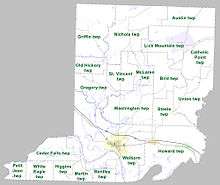
Townships in Arkansas are the divisions of a county. Each township includes unincorporated areas; some may have incorporated cities or towns within part of their boundaries. Arkansas townships have limited purposes in modern times. However, the United States Census does list Arkansas population based on townships (sometimes referred to as "county subdivisions" or "minor civil divisions"). Townships are also of value for historical purposes in terms of genealogical research. Each town or city is within one or more townships in an Arkansas county based on census maps and publications. The townships of Conway County are listed below; listed in parentheses are the cities, towns, and/or census-designated places that are fully or partially inside the township. [22][23]
- Austin
- Bentley (Oppelo)
- Bird
- Catholic Point
- Cedar Falls
- Gregory
- Griffin
- Higgins
- Howard (Menifee, Plumerville)
- Lick Mountain (CDP Center Ridge)
- Martin
- McLaren
- Nichols
- Old Hickory
- Petit Jean
- St. Vincent
- Steele
- Union
- Washington
- Welborn (Morrilton)
- White Eagle
Infrastructure
See also
- David J. Sanders, state senator who represents Conway County
- National Register of Historic Places listings in Conway County, Arkansas
- Rick Beck, state representative for Conway and Perry counties; resides in Center Ridge
Notes
- Mileages from Conway County to Little Rock, Fort Smith, and Memphis are based on highway miles using county seat Morrilton for Conway County.[6]
References
- "State & County QuickFacts". United States Census Bureau. Retrieved May 20, 2014.
- "Find a County". National Association of Counties. Archived from the original on 2011-05-31. Retrieved 2011-06-07.
- "Centers of Population by State: 2010". United States Census Bureau. Archived from the original on January 3, 2014. Retrieved May 24, 2014.
- Rogers, Aaron W. (September 18, 2019). "Morrilton (Conway County)". Encyclopedia of Arkansas. Little Rock: Butler Center for Arkansas Studies at the Central Arkansas Library System. Retrieved January 12, 2020.
- "2010 Census Gazetteer Files". United States Census Bureau. August 22, 2012. Retrieved August 25, 2015.
- "Google Maps (Search for Morrilton, AR)". Google. Retrieved January 11, 2020.
- Mosby, Joe (February 25, 2013). "Partners Created Ed Gordon/Point Remove WMA". Fort Smith Times Record. Fort Smith, AR – via NewsBank.
- Nelson, Rex (October 16, 2019). "The Catholic Point Italians". Arkansas Democrat-Gazette. Little Rock, AR: Arkansas Democrat-Gazette, Inc. p. 7B. Retrieved January 11, 2020 – via NewsBank.
- Staff (July 19, 1999). "Lake Brewer at a glance". Arkansas Democrat-Gazette Inc. Little Rock, AR. p. C3. Retrieved January 11, 2020 – via NewsBank.
- GIS Staff (November 21, 2019). Cherokee WMA (PDF) (Map). 1:70000. Little Rock: Arkansas Game & Fish Commission. p. 7. Retrieved January 11, 2020.
- GIS Staff (July 19, 2019). Piney Creeks WMA (PDF) (Map). 1:100000. Little Rock: Arkansas Game & Fish Commission. p. 5. Retrieved January 11, 2020.
- "Population and Housing Unit Estimates". Retrieved September 28, 2019.
- "U.S. Decennial Census". United States Census Bureau. Retrieved August 25, 2015.
- "Historical Census Browser". University of Virginia Library. Retrieved August 25, 2015.
- Forstall, Richard L., ed. (March 27, 1995). "Population of Counties by Decennial Census: 1900 to 1990". United States Census Bureau. Retrieved August 25, 2015.
- "Census 2000 PHC-T-4. Ranking Tables for Counties: 1990 and 2000" (PDF). United States Census Bureau. April 2, 2001. Retrieved August 25, 2015.
- "Profile of General Population and Housing Characteristics: 2010, 2010 Demographic Profile Data, Conway County, Arkansas". 2010 United States Census. Washington, DC: United States Census Bureau. Archived from the original on February 13, 2020. Retrieved January 12, 2020.
- "Selected Economic Characteristics". United States Census Bureau. 2010. Archived from the original on February 13, 2020. Retrieved March 20, 2019.
- Based on 2000 census data
- "U.S. Census website". United States Census Bureau. Retrieved 2011-05-14.
- "Dave Leip's Atlas of U.S. Presidential Elections". Retrieved November 18, 2016.
- 2011 Boundary and Annexation Survey (BAS): Conway County, AR (PDF) (Map). U. S. Census Bureau. Archived from the original (PDF) on 2012-10-19. Retrieved 2011-08-19.
- "Arkansas: 2010 Census Block Maps - County Subdivision". United States Census Bureau. Retrieved May 27, 2014.
External links
- 10th Arkansas Infantry, Local Regiment During the Civil War
- Conway County Sheriff's Office
Places adjacent to Conway County, Arkansas | ||||||||||
|---|---|---|---|---|---|---|---|---|---|---|
| ||||||||||
Municipalities and communities of Conway County, Arkansas, United States | ||
|---|---|---|
| Cities | Map of Arkansas highlighting Conway County | |
| Town | ||
| CDP | ||
| Unincorporated communities | ||

| Authority control |
|
|---|