Texarkana, Arkansas
Texarkana is a city in the U.S. state of Arkansas and the county seat of Miller County. The city is located across the state line from its twin city, Texarkana, Texas. The city was founded at a railroad intersection on December 8, 1873, and was incorporated in Arkansas on August 10, 1880. Texarkana (together with its Texas counterpart) is the principal city of the Texarkana metropolitan area, which is ranked 274th in terms of population in the United States with 150,098 in 2016 according to the United States Census Bureau.
Texarkana, Arkansas | |
|---|---|
| City of Texarkana | |
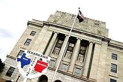 Texarkana federal building, including the post office and courthouse, straddling the Texas-Arkansas state line | |
 Seal | |
| Nickname(s): The Arkansas Side, T-town, TXK | |
| Motto(s): Twice as Nice | |
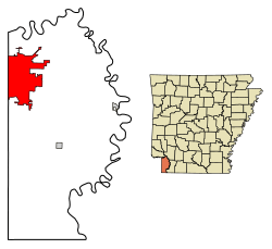 Location of Texarkana in Miller County, Arkansas. | |
 Texarkana, Arkansas Location in the United States | |
| Coordinates: 33°25′59″N 94°1′14″W | |
| Country | United States |
| Incorporated | August 10, 1880 |
| Government | |
| • Type | Council-Manager |
| • Mayor | Allen L. Brown |
| • Board of Directors | Directors
|
| • City Manager | Kenneth Haskins |
| Area | |
| • Total | 42.07 sq mi (108.96 km2) |
| • Land | 41.89 sq mi (108.50 km2) |
| • Water | 0.18 sq mi (0.46 km2) |
| Elevation | 361 ft (110 m) |
| Population (2010) | |
| • Total | 29,919 |
| • Estimate (2019)[2] | 29,657 |
| • Density | 707.96/sq mi (273.35/km2) |
| Time zone | UTC−6 (Central (CST)) |
| • Summer (DST) | UTC−5 (CDT) |
| ZIP code | 71854 |
| Area code(s) | 870 |
| FIPS code | 05-68810 |
| GNIS feature ID | 0078542 |
| Website | arkansas |
Located within the Ark-La-Tex subregion of Southwest Arkansas, Texarkana is located in the Piney Woods, an oak-hickory forest atop the flat Gulf Coastal Plain. Texarkana's economy is driven by agriculture and the city's position as a crossroads of three major Interstate highways: Interstate 30 (I-30), I-49 and the future I-69. Outdoors tourism, such as fishing at Lake Millwood, are also important in the region. The Texarkana Arkansas School District is the largest public school district on the Arkansas side, leading to graduation from Arkansas High School. The city is home to Texarkana College (on the Texas side of town), and a branch campus of the University of Arkansas Community College at Hope (UACCH).
History
Miller County, on the Arkansas side of the metropolitan area, was abolished during the border dispute between the Republic of Texas and the United States only to be re-established later. Miller County was formed in 1820 to honor James Miller, Arkansas' first governor. Miller County was formed with a large degree of uncertainty as to the location of the line dividing the county and the Mexican boundary. Consequently, settlers felt that Arkansas levied and collected taxes on land that eventually might be held by Mexico. Moreover, many who resented the oppression of Texans by the Mexicans were openly declaring allegiance to the Texans. This led to general unrest, and after the Texas Republic was created, it grew worse. So, in 1838, Governor James Conway proposed that the "easiest and most effective remedy is the abolition of Miller County to an area which is more patriotic." From that year until 1874, it was a part of Lafayette County, Arkansas. Its re-establishment sprung only from the sale of town lots in Texarkana in 1873. Efforts of the young town to be incorporated were not realized until October 17, 1880, nearly seven years after Texarkana, Texas (June 12, 1874), was formed. December 8, 1873, is generally recognized by both cities as the date of organization.[3]
Geography
Texarkana, Arkansas, is located at 33°25′59″N 94°1′14″W (33.433075, -94.020514).[4] According to the United States Census Bureau, the city has a total area of 41.9 square miles (108.4 km2), of which 41.7 square miles (107.9 km2) is land and 0.19 square miles (0.5 km2) (0.43%) is water.[5]
Climate
The climate in this area is characterized by hot, humid summers and generally mild to cool winters. According to the Köppen Climate Classification system, Texarkana has a humid subtropical climate, abbreviated "Cfa" on climate maps.[6]
Demographics
| Historical population | |||
|---|---|---|---|
| Census | Pop. | %± | |
| 1880 | 1,390 | — | |
| 1890 | 3,528 | 153.8% | |
| 1900 | 4,914 | 39.3% | |
| 1910 | 5,655 | 15.1% | |
| 1920 | 8,257 | 46.0% | |
| 1930 | 10,764 | 30.4% | |
| 1940 | 11,821 | 9.8% | |
| 1950 | 15,875 | 34.3% | |
| 1960 | 19,788 | 24.6% | |
| 1970 | 21,682 | 9.6% | |
| 1980 | 21,459 | −1.0% | |
| 1990 | 22,631 | 5.5% | |
| 2000 | 26,448 | 16.9% | |
| 2010 | 29,919 | 13.1% | |
| Est. 2019 | 29,657 | [2] | −0.9% |
| U.S. Decennial Census[7] | |||
As of the census[8] of 2016, there were 30,283 people, 13,565 households, and 7,040 families residing in the city. The population density was 830.5 people per square mile (320.6/km2). There were 11,721 housing units at an average density of 368.1 per square mile (142.1/km2). The racial makeup of the city was 65.93% White, 31.00% Black or African American, 0.48% Native American, 0.50% Asian, 0.03% Pacific Islander, 0.61% from other races, and 1.46% from two or more races. Hispanic or Latino of any race were 1.78% of the population.
There were 13,565 households, out of which 32.5% had children under the age of 18 living with them, 45.3% were married couples living together, 18.7% had a female householder with no husband present, and 32.2% were non-families. 28.3% of all households were made up of individuals, and 11.6% had someone living alone who was 65 years of age or older. The average household size was 2.45 and the average family size was 2.99.
In the city, the population was spread out, with 25.9% under the age of 18, 10.1% from 18 to 24, 28.5% from 25 to 44, 21.5% from 45 to 64, and 14.0% who were 65 years of age or older. The median age was 35 years. For every 100 females, there were 92.0 males. For every 100 females age 18 and over, there were 87.0 males.
The median income for a household in the city was $31,343, and the median income for a family was $38,292 . Males had a median income of $35,204 versus $21,731 for females. The per capita income for the city was $17,130. About 17.2% of families and 21.7% of the population were below the poverty line, including 33.0% of those under age 18 and 15.7% of those age 65 or above.
Government and infrastructure
The Arkansas Department of Correction operates the Texarkana Regional Correction Center in Texarkana.[9]
Arkansas residents whose permanent residence is within the city limits of Texarkana, Arkansas are exempt from Arkansas individual income taxes.[10]
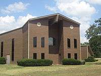
The Federal Courthouse (which also holds the city's only post office) is located directly on the Arkansas-Texas state line and is the only federal office building to straddle a state line.
According to the City's 2018 Comprehensive Annual Financial Report,[5] the top employers in the area are:
- Red River Army Depot & Tenants 4,135,
- Christus St. Michael Health Care 1,800,
- Cooper Tire & Rubber Company 1,750,
- AECOM/URS 1,300,
- Southern Refrigerated Transport 1,235,
- Wal-Mart 1,200,
- Texarkana TX Independent School District 1,150,
- Domtar, Inc. 900,
- Graphic Packaging 800,
- Wadley Regional Medical Center 755,
- Texarkana Arkansas School District 785,
Transportation
- Texarkana (Amtrak station)
- Texarkana Regional Airport
Highways
.svg.png)
.svg.png)


Education
Public education for elementary and secondary school students is provided by two school districts:
- Texarkana Arkansas School District, which leads to graduating from Arkansas High School. The high school mascot is the Razorback, which was eventually selected for use by the University of Arkansas in exchange for used athletic equipment—a practice that no longer occurs.[11]
- A very small portion of the city is within the Genoa Central School District,[12] which leads to graduation from Genoa Central High School. The high school mascot is the Dragon with green and white serving as the school colors.
Private education opportunities include:
- Trinity Christian School, a Baptist school serving prekindergarten through grade 12
In 2012, Texarkana became home to a branch of the University of Arkansas Hope-Texarkana (UAHT), a community college based in Hope, Arkansas, and in 2015 UAHT began partnering with the University of Arkansas Little Rock, to offer bachelor's-degree programs through UALR Texarkana, based on the UAHT Texarkana campus.[13]
Pop culture
- Texarkana is referenced in the song "Cotton Fields" by the American folk and blues musician Lead Belly and later recorded by several notable country rock artists, including The Highwaymen, Buck Owens, The Beach Boys, Elton John and Creedence Clearwater Revival. Lead Belly (Huddie Ledbetter), was born on a cotton plantation near Linden, Texas, about 40 miles southwest of Texarkana, and later worked on a plantation near De Kalb, Texas, about 35 miles west of Texarkana.
- Brenda Lee's 1959 song "Let's Jump the Broomstick" references the city with the lyric "Goin' to Alabama back from Texarkana, Goin' all around the world".
- Texarkana is one of the places visited by the red car in The Brave Little Toaster during the song "Worthless"
- Tesla's 1991 song "Call It What You Want" contains the lyric "All I am is all I'll ever be, and that's just a boy from Texarkana." As the lead singer of the band is actually from Texarkana, this lyric is notably autobiographical.
- "Texarkana" is a 1991 song by R.E.M.. The track appears on the band's seventh studio album, Out of Time.
- Other popular songs that name-check the city include "All My Ex's Live in Texas" by George Strait, "I've Been Everywhere" by Hank Snow, later covered by Johnny Cash; "Texas Swing" by Clay Walker from his 2001 album Say No More; "Gimme Gimme Good Lovin'" by Crazy Elephant; "24 Hours at a Time" by the Marshall Tucker Band; "Texarkana Baby" by Bob Wills and the Texas Playboys, covered by Tennessee Ernie Ford; "Texarkana" by the husband and wife duo, Texarkana; and two songs by Joe Ely, "Fingernails" and "I'm Gonna Strangle You Shorty."
- In the 1977 movie Smokey and the Bandit, The Bandit (Burt Reynolds and the Snowman Jerry Reed) are making a run from Atlanta to Texarkana to get a load of beer. Jerry Reed's 1977 hit song "East Bound and Down" from the soundtrack refers to the city in the lyric "The boys are thirsty in Atlanta and there's beer in Texarkana," regarding the lack of availability of Coors beer east of Texas at that time. (In fact, Texarkana, Texas was dry until 2014 - the alcohol distributor is actually in Texarkana, Arkansas.)
- In Season 5, Episode 5 "Southbound and Down" of the FX TV show Archer, Archer and the crew from ISIS encounter a hostile biker gang in Texarkana while on their way to Austin, Texas.
- In a 2013 episode of American Pickers on The History Channel, Frank and Mike visited several spots in Texarkana.
- In the movie Zombieland, Woody Harrelson refers to the relationship with his new zombie-killing companion, Jesse Eisenberg, that he figures it will last "all the way to Texarkana".
- Used as setting for the 1976 movie The Town That Dreaded Sundown, which was loosely based on a series of murders that occurred in the town in the spring of 1946.
- In the novel A Canticle for Leibowitz, centuries after a nuclear war that reduces world civilization to a second dark age, Texarkana rises as the capital of a burgeoning empire that expands across the former United States and becomes known as the Atlantic Confederacy.
- In 2009, the end scene of Sacha Baron Cohen's Movie "Brüno" was filmed in Texarkana
- In 2016, a video of a speech defending LGBT rights by a Texarkana minister went viral online.[14]
Notable people
- Buster Benton, blues singer-guitarist[15]
- Ben M. Bogard, founder in 1924 of the American Baptist Association; while living in Texarkana, Arkansas, in 1914 he founded The Baptist Commoner denominational newspaper, later in 1917 combined as The Baptist and Commoner[16]
- Brad Cherry, relief pitcher for the Cincinnati Reds of Major League Baseball and pitcher for UALR College[17]
- Mike Cherry, New York Giants football, Murray State quarterback[18]
- Martin Delray, country music singer
- Wayne Dowd, Arkansas State Senator and lawyer
- Prissy Hickerson, former member of Arkansas Highway Commission for which Loop 245 is named "Hickerson Highway"; current member of Arkansas House of Representatives from Miller County[19]
- Jimmy Hickey Jr., Arkansas state senator from District 11 in Miller, Lafayette, Little River, Hempstead, and Sevier counties; Texarkana businessman[20]
- Mike Huckabee, governor; pastored Beech Street First Baptist Church, 1986-1992[21]
- Parnelli Jones, 1963 Indianapolis 500 champion
- Scott Joplin, musician and preeminent composer of Ragtime
- Jeff Keith, lead singer of rock band Tesla
- Dana Kimmell, actress
- A. Lynn Lowe, farmer and former Arkansas Republican Party state chairman and 1978 gubernatorial nominee against Bill Clinton
- Dustin Moseley, Major League Baseball player with the San Diego Padres in the MLB
- Conlon Nancarrow, innovative composer who specialized in works for the player piano
- Charles B. Pierce, director and movie producer of The Legend of Boggy Creek and The Town That Dreaded Sundown
- Don Rogers, football player with Cleveland Browns in the NFL
- Mike Ross, Former U.S. Representative and 2014 Arkansas gubernatorial nominee
- Max Sandlin, Former U.S. Representative from Texas, and husband of former Congresswoman Stephanie Herseth Sandlin from South Dakota's at-large congressional district
- Rod Smith, football player with Denver Broncos in the NFL two time Super Bowl Champion
- Gunnar Stansson, YouTube celebrity, the star of videos such as Unforgivable.
- Jasper Taylor, early jazz drummer, recorded with Jelly Roll Morton, Freddy Keppard, many others
- Jerry Turner, former Major League Baseball outfielder
- Dennis Woodberry, player with Washington Redskins in the NFL and one-time Super Bowl champion
- Willie Davis, player with Green Bay Packers in the NFL and Super Bowl champion
References
- "2019 U.S. Gazetteer Files". United States Census Bureau. Retrieved June 30, 2020.
- "Population and Housing Unit Estimates". United States Census Bureau. May 24, 2020. Retrieved May 27, 2020.
- "Texarkana Chamber of Commerce". Texarkana.org. Archived from the original on April 5, 2015. Retrieved April 7, 2015.
- "US Gazetteer files: 2010, 2000, and 1990". United States Census Bureau. 2011-02-12. Retrieved 2011-04-23.
- "Geographic Identifiers: 2010 Demographic Profile Data (G001): Texarkana city, Arkansas". U.S. Census Bureau, American Factfinder. Archived from the original on February 12, 2020. Retrieved April 16, 2014.
- "Texarkana, Arkansas Köppen Climate Classification". Weatherbase.com. Retrieved 2016-07-25.
- "Census of Population and Housing". Census.gov. Retrieved June 4, 2016.
- "U.S. Census website". United States Census Bureau. Retrieved 2008-01-31.
- "Arkansas Department of Corrections". Adc.arkansas.gov. Retrieved 2016-07-25.
- "State of Arkansas Department of Finance and Administration Texarkana Exemption Letter" (PDF). Dfa.arkansas.gov. Retrieved March 26, 2011.
- "History of Texarkana: Did You Know?". Texarkana Arkansas School District. Archived from the original on 22 February 2013. Retrieved 5 November 2012.
- "SCHOOL DISTRICT REFERENCE MAP (2010 CENSUS): Miller County, AR." U.S. Census Bureau. Retrieved on October 15, 2017.
- "University of Arkansas at Little Rock". Ualr.edu. Archived from the original on 2017-06-08. Retrieved 2017-06-05.
- "Facebook". Facebook. Retrieved 2016-07-25.
- Bill Dahl. "Buster Benton | Biography & History". AllMusic. Retrieved 2017-07-09.
- "Benjamin Marcus Bogard (1868–1951)". encyclopediaofarkansas.net. Retrieved August 2, 2013.
- "Brad Cherry Register Statistics & History". Baseball-Reference.com. 1981-02-12. Retrieved 2016-07-25.
- "Mike Cherry, QB at". Nfl.com. Retrieved 2016-07-25.
- "Representative Prissy Hickerson's Political Summary". votesmart.org. Retrieved September 10, 2013.
- "Biography of the Honorable Jimmy Hickey, Jr., Arkansas State Senator" (PDF). arkleg.state.ar.us. Retrieved December 5, 2013.
- Mike Huckabee, From Hope to Higher Ground, New York: Center Street Publishers, 2007, p. 5
External links
| Wikimedia Commons has media related to Texarkana, Arkansas. |
- City of Texarkana
- Texarkana Business Reviews
- History of Texarkana's Jewish community (from the Institute of Southern Jewish Life)
- Encyclopedia of Arkansas History & Culture entry: Texarkana (Miller County)
Municipalities and communities of Miller County, Arkansas, United States | ||
|---|---|---|
| Cities | 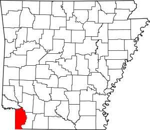 Map of Arkansas highlighting Miller County | |
| Town | ||
| Unincorporated communities | ||
| Authority control |
|
|---|