Pulaski County, Arkansas
Pulaski County is a county in the U.S. state of Arkansas with a population of 391,911,[1] making it the most populous county in Arkansas. Its county seat is Little Rock,[2] which is also Arkansas's capital and largest city. Pulaski County is Arkansas's fifth county, formed on December 15, 1818, alongside Clark and Hempstead Counties. The county is named for Casimir Pulaski, a Polish volunteer who saved George Washington's life during the American Revolutionary War.
Pulaski County | |
|---|---|
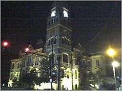
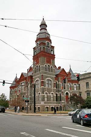 Pulaski County Courthouse, in downtown Little Rock | |
 Flag  Seal | |
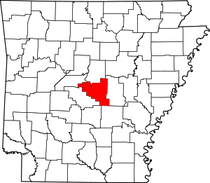 Location within the U.S. state of Arkansas | |
 Arkansas's location within the U.S. | |
| Coordinates: 34°44′32″N 92°17′09″W | |
| Country | |
| State | |
| Founded | December 15, 1818 |
| Named for | Casimir Pulaski |
| Seat | Little Rock |
| Largest city | Little Rock |
| Area | |
| • Total | 808 sq mi (2,090 km2) |
| • Land | 760 sq mi (2,000 km2) |
| • Water | 48 sq mi (120 km2) 5.9%% |
| Population (2010) | |
| • Total | 382,748 |
| • Estimate (2019) | 391,911 |
| • Density | 470/sq mi (180/km2) |
| Time zone | UTC−6 (Central) |
| • Summer (DST) | UTC−5 (CDT) |
| Congressional district | 2nd |
| Website | pulaskicounty |
Pulaski County is included in the Little Rock–North Little Rock–Conway, AR Metropolitan Statistical Area which had 731,612 people in the 2015 census estimates. The Little Rock, North Little Rock Combined Statistical Area had 904,469 people in the 2015 census estimates.
History
U. M. Rose, a pro-Confederate attorney, was county chancellor (judge and chief county executive) from 1860 until the fall of Little Rock to Union forces on September 1, 1863.
An 1863 American Civil War battle, the Battle of Bayou Fourche, occurred a few days later in Pulaski County.
Pulaski County was home to Willow Springs Water Park, one of the oldest water parks in the nation, which opened in 1928 and closed in 2013.
.jpg) Cotton pickers receiving sixty cents a day ($10.81 in 2017 dollars), Pulaski County, Arkansas, October 1935. Ben Shahn, photographer. From the Farm Security Administration Collection.
Cotton pickers receiving sixty cents a day ($10.81 in 2017 dollars), Pulaski County, Arkansas, October 1935. Ben Shahn, photographer. From the Farm Security Administration Collection.
Geography
According to the U.S. Census Bureau, the county has a total area of 808 square miles (2,090 km2), of which 760 square miles (2,000 km2) is land and 48 square miles (120 km2) (5.9%) is water.[3]
Major highways


.svg.png)


Adjacent counties
- Faulkner County (north)
- Lonoke County (east)
- Grant County (south)
- Jefferson County (south)
- Saline County (west)
- Perry County (northwest)
- Little Rock Central High School National Historic Site
- I-30 Speedway
Demographics
| Historical population | |||
|---|---|---|---|
| Census | Pop. | %± | |
| 1830 | 2,395 | — | |
| 1840 | 5,350 | 123.4% | |
| 1850 | 5,657 | 5.7% | |
| 1860 | 11,699 | 106.8% | |
| 1870 | 32,066 | 174.1% | |
| 1880 | 32,616 | 1.7% | |
| 1890 | 47,329 | 45.1% | |
| 1900 | 63,179 | 33.5% | |
| 1910 | 86,751 | 37.3% | |
| 1920 | 109,464 | 26.2% | |
| 1930 | 137,727 | 25.8% | |
| 1940 | 156,085 | 13.3% | |
| 1950 | 196,685 | 26.0% | |
| 1960 | 242,980 | 23.5% | |
| 1970 | 287,189 | 18.2% | |
| 1980 | 340,613 | 18.6% | |
| 1990 | 349,660 | 2.7% | |
| 2000 | 361,474 | 3.4% | |
| 2010 | 382,748 | 5.9% | |
| Est. 2019 | 391,911 | [4] | 2.4% |
| U.S. Decennial Census[5] 1790–1960[6] 1900–1990[7] 1990–2000[8] 2010–2016[1] | |||
As of the 2000 United States Census,[10] there were 361,474 people, 147,942 households, and 95,718 families residing in the county. The population density was 469 people per square mile (181/km²). There were 161,135 housing units at an average density of 209 per square mile (81/km²). The racial makeup of the county was 63.96% White, 31.87% Black or African American, 0.39% Native American, 1.25% Asian, 0.04% Pacific Islander, 1.09% from other races, and 1.40% from two or more races. 2.44% of the population were Hispanic or Latino of any race.
There were 147,942 households out of which 30.50% had children under the age of 18 living with them, 45.90% were married couples living together, 15.10% had a female householder with no husband present, and 35.30% were non-families. 30.00% of all households were made up of individuals and 8.80% had someone living alone who was 65 years of age or older. The average household size was 2.39 and the average family size was 2.98.
In the county, the population was spread out with 25.20% under the age of 18, 9.60% from 18 to 24, 31.10% from 25 to 44, 22.60% from 45 to 64, and 11.50% who were 65 years of age or older. The median age was 35 years. For every 100 females, there were 92.00 males. For every 100 females age 18 and over, there were 88.20 males.
The median income for a household in the county was $38,120, and the median income for a family was $46,523. Males had a median income of $33,131 versus $25,943 for females. The per capita income for the county was $21,466. About 10.40% of families and 13.30% of the population were below the poverty line, including 19.90% of those under age 18 and 9.80% of those age 65 or over.
Government and infrastructure
The Arkansas Department of Correction Wrightsville Unit is in Wrightsville.[11]
Politics
Pulaski County is one of the most Democratic counties in Arkansas and the Southern United States. The city of North Little Rock was ranked the most liberal community in the state.[12] In the Reconstruction Era following the Civil War, Republicans carried the county in every presidential election from 1868 to 1892. Since then, Republicans have only won the county four times: 1956, 1972, 1984, and 1988.
| Year | REP | DEM | Others |
|---|---|---|---|
| 2016 | 38.34% 61,257 | 56.06% 89,574 | 5.60% 8,945 |
| 2012 | 43.28% 68,984 | 54.74% 87,248 | 1.98% 3,149 |
| 2008 | 43.52% 70,212 | 55.07% 88,854 | 1.41% 2,277 |
| 2004 | 44.20% 67,903 | 55.03% 84,532 | 0.77% 1,185 |
| 2000 | 43.94% 55,866 | 53.73% 68,320 | 2.33% 2,965 |
| 1996 | 35.06% 44,780 | 58.78% 75,084 | 6.16% 7,869 |
| 1992 | 34.89% 47,789 | 58.03% 79,482 | 7.07% 9,686 |
| 1988 | 54.98% 70,562 | 43.53% 55,857 | 1.49% 1,914 |
| 1984 | 58.20% 77,651 | 40.65% 54,237 | 1.15% 1,530 |
| 1980 | 46.15% 52,125 | 48.56% 54,839 | 5.29% 5,973 |
| 1976 | 37.14% 37,690 | 62.62% 63,541 | 0.24% 244 |
| 1972 | 62.95% 57,576 | 36.75% 33,611 | 0.31% 281 |
| 1968 | 33.32% 26,709 | 34.43% 27,597 | 32.24% 25,844 |
| 1964 | 48.32% 38,312 | 51.12% 40,535 | 0.56% 442 |
| 1960 | 39.70% 22,146 | 46.67% 26,034 | 13.64% 7,608 |
| 1956 | 51.10% 25,702 | 46.46% 23,372 | 2.44% 1,227 |
| 1952 | 48.59% 23,460 | 50.63% 24,448 | 0.78% 378 |
| 1948 | 23.99% 5,910 | 53.25% 13,120 | 22.76% 5,609 |
| 1944 | 26.87% 6,069 | 72.91% 16,470 | 0.22% 50 |
| 1940 | 17.15% 2,955 | 82.52% 14,219 | 0.33% 56 |
| 1936 | 10.29% 1,320 | 89.49% 11,482 | 0.22% 28 |
| 1932 | 13.87% 2,281 | 85.46% 14,049 | 0.67% 110 |
| 1928 | 34.55% 4,880 | 65.24% 9,215 | 0.21% 29 |
| 1924 | 28.36% 2,729 | 59.30% 5,706 | 12.34% 1,187 |
| 1920 | 35.80% 3,711 | 62.76% 6,506 | 1.45% 150 |
| 1916 | 30.15% 2,593 | 69.85% 6,008 | 0.00% 0 |
| 1912 | 16.76% 1,044 | 54.09% 3,369 | 29.14% 1,815 |
| 1908 | 45.68% 3,533 | 50.33% 3,893 | 3.99% 309 |
| 1904 | 42.44% 2,450 | 53.68% 3,099 | 3.88% 224 |
| 1900 | 41.85% 1,932 | 56.52% 2,609 | 1.62% 75 |
| 1896 | 35.84% 1,754 | 61.73% 3,021 | 2.43% 119 |
| 1892 | 39.07% 2,492 | 53.18% 3,392 | 7.75% 494 |
Education
- The Pulaski County Special School District is the county's public school district for 729 square miles (1,890 km2) surrounding Little Rock and North Little Rock, which maintain independent districts. Also the Little Rock School District and North Little Rock School District.
- Pulaski Technical College is a two-year community college and technical school that offers seven locations throughout the county, including a flagship campus in western North Little Rock.
- Four-year postsecondary institutions include the University of Arkansas at Little Rock, the University of Arkansas System's only metropolitan campus, the United Methodist Church-affiliated Philander Smith College, Arkansas Baptist College, and the University of Arkansas for Medical Sciences — all located in Little Rock.
Communities
Cities
Town
Census-designated places
Other communities
- Crystal Hill
- Gravel Ridge
- Ironton
- Little Italy
- Mabelvale
- Marche
- Natural Steps
- Pankey
- Woodyardville
Townships
Townships in Arkansas are the divisions of a county. Each township includes unincorporated areas and some may have incorporated towns or cities within part of their space. Townships have limited purposes in modern times. However, the US Census does list Arkansas population based on townships (often referred to as "minor civil divisions"). Townships are also of value for historical purposes in terms of genealogical research. Each town or city is within one or more townships in an Arkansas county based on census maps. Pulaski County only has two townships, as of 2010. They are listed below.[14][15]
| Township | FIPS code | ANSI code (GNIS ID) |
Population center(s) |
Pop. (2010) |
Pop. density (/mi²) |
Pop. density (/km²) |
Land area (mi²) |
Land area (km²) |
Water area (mi²) |
Water area (km²) |
Geographic coordinates |
|---|---|---|---|---|---|---|---|---|---|---|---|
| Big Rock | 05-90300 | 69013 | Alexander, Cammack Village, Little Rock, Wrightsville | 219,984 | 506.7 | 195.6 | 404.014 | 1,046 | 30.148 | 78.08 | 34°44′30″N 92°24′43″W |
| Hill | 05-91731 | 69014 | Jacksonville, Maumelle, North Little Rock, Sherwood | 162,764 | 435.8 | 168.3 | 355.750 | 921.4 | 17.753 | 45.98 | 34°48′12″N 92°11′32″W |
| Source: U.S. Census Bureau[16][17] | |||||||||||
See also
- List of lakes in Pulaski County, Arkansas
- National Register of Historic Places listings in Pulaski County, Arkansas
References
- "State & County QuickFacts". United States Census Bureau. Archived from the original on July 17, 2011. Retrieved April 22, 2016.
- "Find a County". National Association of Counties. Retrieved June 7, 2011.
- "2010 Census Gazetteer Files". United States Census Bureau. August 22, 2012. Retrieved August 27, 2015.
- "Population and Housing Unit Estimates". Retrieved September 28, 2019.
- "U.S. Decennial Census". United States Census Bureau. Retrieved August 27, 2015.
- "Historical Census Browser". University of Virginia Library. Retrieved August 27, 2015.
- Forstall, Richard L., ed. (March 27, 1995). "Population of Counties by Decennial Census: 1900 to 1990". United States Census Bureau. Retrieved August 27, 2015.
- "Census 2000 PHC-T-4. Ranking Tables for Counties: 1990 and 2000" (PDF). United States Census Bureau. April 2, 2001. Retrieved August 27, 2015.
- Based on 2000 census data
- "U.S. Census website". United States Census Bureau. Retrieved January 31, 2008.
- Facilities 5. Arkansas Department of Corrections. Retrieved on March 8, 2011.
- Kiersz, Hunter Walker, Andy. "Here Are The Most Liberal And Most Conservative Towns In Each State". Business Insider. Retrieved July 5, 2020.
- "Dave Leip's Atlas of U.S. Presidential Elections". Retrieved November 15, 2016.
- 2011 Boundary and Annexation Survey (BAS): Pulaski County, AR (PDF) (Map). U. S. Census Bureau. Archived from the original (PDF) on October 19, 2012. Retrieved August 24, 2011.
- "Arkansas: 2010 Census Block Maps - County Subdivision". United States Census Bureau. Retrieved June 28, 2014.
- "County Subdivisions: Arkansas". Census 2010 U.S. Gazetteer Files. United States Census Bureau. Archived from the original (TXT) on May 31, 2014. Retrieved June 28, 2014.
- "Census 2010 U.S. Gazetteer Files". United States Census Bureau. Retrieved June 28, 2014.
External links
- Pulaski County Government
- Pulaski County, Arkansas entry on the Encyclopedia of Arkansas History & Culture
Places adjacent to Pulaski County, Arkansas | ||||||||||
|---|---|---|---|---|---|---|---|---|---|---|
| ||||||||||
Municipalities and communities of Pulaski County, Arkansas, United States | ||
|---|---|---|
| Cities | Map of Arkansas highlighting Pulaski County | |
| CDPs | ||
| Unincorporated communities | ||
| Footnotes | ‡This populated place also has portions in an adjacent county or counties | |

| Authority control |
|
|---|