Garland County, Arkansas
Garland County is a county located in the U.S. state of Arkansas. As of the 2010 census, the population was 96,024.[1] The county seat is Hot Springs.[2]
Garland County | |
|---|---|
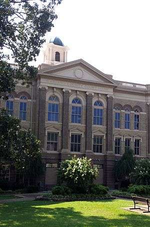 Garland County Courthouse | |
 Seal | |
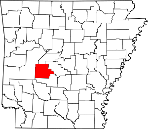 Location within the U.S. state of Arkansas | |
 Arkansas's location within the U.S. | |
| Coordinates: 34°35′01″N 93°07′39″W | |
| Country | |
| State | |
| Founded | April 5, 1873 |
| Named for | Augustus Hill Garland |
| Seat | Hot Springs |
| Largest city | Hot Springs |
| Area | |
| • Total | 735 sq mi (1,900 km2) |
| • Land | 678 sq mi (1,760 km2) |
| • Water | 57 sq mi (150 km2) 7.7%% |
| Population (2010) | |
| • Total | 96,024 |
| • Estimate (2019) | 99,386 |
| • Density | 130/sq mi (50/km2) |
| Time zone | UTC−6 (Central) |
| • Summer (DST) | UTC−5 (CDT) |
| Congressional district | 4th |
| Website | www |
Garland County comprises the Hot Springs, AR Metropolitan Statistical Area. The county includes Hot Springs National Park, the only national park in the state of Arkansas as well as the first property to be protected under federal legislation; a law was passed in 1832 supported by President Andrew Jackson to preserve this area, even before Arkansas was admitted as a state.
History
This area was occupied by the historic Natchitoches people, who frequented the hot springs for their healing powers. Their ancestors among regional indigenous peoples had been coming to this area for thousands of years.
President Thomas Jefferson requested William Dunbar, a planter and amateur scientist of Natchez, to explore this area. Dunbar led small group of a dozen soldiers and friend George Hunter, a chemist, to the Ouachita Mountains to report on the Indian tribes, minerals, and springs. They reached Hot Springs in December 1804, where they found a basic cabin used by visitors to the springs.
The first European-American settler was Jean Pierre Emanuel Prudhomme, a descendant of French colonists. An owner of a plantation at Red River, Prudhomme was suffering from illness and sought relief from the springs. In 1807 he built the first permanent European house by the springs, living here for two years. Isaac Cates and John Percival, two trappers from Alabama, joined him. Percival foresaw a great potential for the area and built log cabins in order to rent to visitors to the springs.[3]
In 1828, Ludovicus Belding came with wife and children to visit the hot springs. After a few months they built a small hotel for the visitors of the springs.[4]
In 1832 President Andrew Jackson signed legislation to protect the hot springs area for recreational use by American citizens as Hot Springs Reservation, the first time such action was taken. This was four years before Arkansas became a state, on June 15, 1836. A dispute among original settlers and their descendants over control of the property was settled by the US Supreme Court in 1877 in favor of the federal government.[3] Hot Springs National Park was established in 1921 and is managed by the National Park Service.[5] Garland County is Arkansas' 68th county, formed on April 5, 1873, from portions of Hot Spring, Montgomery, and Saline counties.[6] It was named for Augustus H. Garland, eleventh governor of Arkansas.[7][8] It is the only county in the United States with this name.
Geography
According to the U.S. Census Bureau, the county has a total area of 735 square miles (1,900 km2), of which 678 square miles (1,760 km2) is land and 57 square miles (150 km2) (7.7%) is water.[9]
Major highways


Adjacent counties
- Perry County (north)
- Saline County (east)
- Hot Spring County (south)
- Montgomery County (west)
- Yell County (northwest)
National protected areas
Demographics
| Historical population | |||
|---|---|---|---|
| Census | Pop. | %± | |
| 1880 | 9,023 | — | |
| 1890 | 15,328 | 69.9% | |
| 1900 | 18,773 | 22.5% | |
| 1910 | 27,271 | 45.3% | |
| 1920 | 25,785 | −5.4% | |
| 1930 | 36,031 | 39.7% | |
| 1940 | 41,664 | 15.6% | |
| 1950 | 47,102 | 13.1% | |
| 1960 | 46,697 | −0.9% | |
| 1970 | 54,131 | 15.9% | |
| 1980 | 70,531 | 30.3% | |
| 1990 | 73,397 | 4.1% | |
| 2000 | 88,068 | 20.0% | |
| 2010 | 96,024 | 9.0% | |
| Est. 2019 | 99,386 | [10] | 3.5% |
| U.S. Decennial Census[11] 1790–1960[12] 1900–1990[13] 1990–2000[14] 2010–2016[1] | |||
As of the 2000 United States Census,[16] there were 88,068 people, 37,813 households, and 25,259 families residing in the county. The population density was 130 people per square mile (50/km²). There were 44,953 housing units at an average density of 66 per square mile (26/km²). The racial makeup of the county was 88.85% White, 7.80% Black or African American, 0.61% Native American, 0.50% Asian, 0.03% Pacific Islander, 0.72% from other races, and 1.49% from two or more races. 2.56% of the population were Hispanic or Latino of any race.
There were 37,813 households out of which 25.10% had children under the age of 18 living with them, 53.20% were married couples living together, 10.10% had a female householder with no husband present, and 33.20% were non-families. 28.80% of all households were made up of individuals and 13.50% had someone living alone who was 65 years of age or older. The average household size was 2.28 and the average family size was 2.78.
In the county, the population was spread out with 21.30% under the age of 18, 7.30% from 18 to 24, 25.20% from 25 to 44, 25.10% from 45 to 64, and 21.20% who were 65 years of age or older. The median age was 42 years. For every 100 females there were 94.40 males. For every 100 females age 18 and over, there were 90.80 males.
The median income for a household in the county was $31,724, and the median income for a family was $38,079. Males had a median income of $28,117 versus $20,421 for females. The per capita income for the county was $18,631. About 10.50% of families and 14.60% of the population were below the poverty line, including 22.70% of those under age 18 and 8.60% of those age 65 or over.
Communities
Cities
- Hot Springs (county seat)
Census-designated places
Unincorporated communities
Townships
Townships in Arkansas are the divisions of a county. Each township includes unincorporated areas; some may have incorporated cities or towns within part of their boundaries. Arkansas townships have limited purposes in modern times. However, the United States Census does list Arkansas population based on townships (sometimes referred to as "county subdivisions" or "minor civil divisions"). Townships are also of value for historical purposes in terms of genealogical research. Each town or city is within one or more townships in an Arkansas county based on census maps and publications. The townships of Garland County are listed below; listed in parentheses are the cities, towns, and/or census-designated places that are fully or partially inside the township. [17][18]
| Township | FIPS code | ANSI code (GNIS ID) |
Population center(s) |
Pop. (2010) |
Pop. density (/mi²) |
Pop. density (/km²) |
Total area (mi²) |
Total area (km²) |
Land area (mi²) |
Land area (km²) |
Water area (mi²) |
Water area (km²) |
Geographic coordinates |
|---|---|---|---|---|---|---|---|---|---|---|---|---|---|
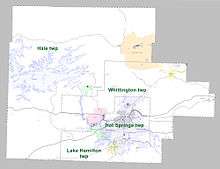
| Hale | 05-91581 | 00066591 | Mountain Pine, most of CDP Hot Springs Village, small part of CDP Rockwell | 16,142 | 41.99 | 16.21 | 428.979 | 1,111 | 384.389 | 995.6 | 44.590 | 115.5 | 34.633909°N 93.198598°W |
| Hot Springs | 05-91773 | 00066592 | most of Hot Springs | 41,479 | 801.70 | 309.54 | 54.073 | 140.0 | 51.739 | 134.0 | 2.334 | 6.045 | 34.494338°N 93.047883°W |
| Lake Hamilton | 05-92100 | 00066594 | CDP Lake Hamilton, most of CDP Rockwell | 20,534 | 260.45 | 100.56 | 86.717 | 224.6 | 78.839 | 204.2 | 7.878 | 20.40 | 34.431040°N 93.086323°W |
| Whittington | 05-94047 | 00066602 | Fountain Lake, Lonsdale, CDP Piney, part of CDP Hot Springs Village, small part of Hot Springs | 17,599 | 108.09 | 41.73 | 164.852 | 427.0 | 162.814 | 421.7 | 2.038 | 5.278 | 34.568990°N 92.999676°W |
| Source: "Census 2010 U.S. Gazetteer Files: County Subdivisions in Arkansas". U.S. Census Bureau, Geography Division. Archived from the original on 2014-05-31.
Source: "Census 2010 U.S. Gazetteer Files". U.S. Census Bureau, Geography Division. | |||||||||||||
Government and politics
Over the past few election cycles Garland County has trended heavily towards the GOP. The last Democrat to carry this county was Arkansas “favorite son” Bill Clinton in 1996.
| Year | GOP | Dem | Others |
|---|---|---|---|
| 2016 | 63.93% 26,087 | 30.17% 12,311 | 5.90% 2,407 |
| 2012 | 63.87% 26,014 | 33.89% 13,804 | 2.23% 910 |
| 2008 | 61.36% 26,825 | 36.37% 15,899 | 2.28% 995 |
| 2004 | 54.13% 21,734 | 44.93% 18,040 | 0.95% 380 |
| 2000 | 53.15% 19,098 | 44.08% 15,840 | 2.78% 997 |
| 1996 | 37.73% 13,662 | 53.06% 19,211 | 9.21% 3,333 |
| 1992 | 35.80% 12,886 | 52.26% 18,811 | 11.94% 4,298 |
| 1988 | 60.93% 19,281 | 36.05% 11,406 | 3.02% 955 |
| 1984 | 62.47% 21,213 | 33.82% 11,484 | 3.71% 1,261 |
| 1980 | 52.96% 15,739 | 42.11% 12,515 | 4.93% 1,463 |
| 1976 | 39.72% 10,394 | 60.02% 15,707 | 0.26% 69 |
| 1972 | 73.90% 15,602 | 24.66% 5,207 | 1.44% 303 |
| 1968 | 37.83% 7,674 | 27.88% 5,655 | 34.29% 6,955 |
| 1964 | 46.01% 9,952 | 53.59% 11,591 | 0.40% 86 |
| 1960 | 51.66% 7,204 | 45.42% 6,333 | 2.92% 407 |
| 1956 | 62.53% 9,427 | 36.06% 5,437 | 1.41% 212 |
| 1952 | 60.07% 7,848 | 39.53% 5,165 | 0.40% 52 |
| 1948 | 31.95% 2,286 | 52.61% 3,764 | 15.43% 1,104 |
| 1944 | 36.50% 2,069 | 63.43% 3,596 | 0.07% 4 |
| 1940 | 29.84% 1,424 | 69.89% 3,335 | 0.27% 13 |
| 1936 | 29.09% 1,217 | 70.07% 2,931 | 0.84% 35 |
| 1932 | 16.38% 833 | 83.60% 4,252 | 0.02% 1 |
| 1928 | 48.94% 2,720 | 50.79% 2,823 | 0.27% 15 |
| 1924 | 37.50% 1,064 | 52.91% 1,501 | 9.59% 272 |
| 1920 | 45.45% 1,423 | 51.71% 1,619 | 2.84% 89 |
| 1916 | 38.65% 1,057 | 61.35% 1,678 | 0.00% 0 |
| 1912 | 14.80% 300 | 51.60% 1,046 | 33.60% 681 |
| 1908 | 42.91% 1,105 | 52.04% 1,340 | 5.05% 130 |
| 1904 | 50.92% 854 | 47.94% 804 | 1.13% 19 |
| 1900 | 42.62% 708 | 56.59% 940 | 0.78% 13 |
| 1896 | 31.33% 703 | 65.29% 1,465 | 3.39% 76 |
See also
- List of lakes in Garland County, Arkansas
- National Register of Historic Places listings in Garland County, Arkansas
References
- "State & County QuickFacts". United States Census Bureau. Archived from the original on June 7, 2011. Retrieved May 21, 2014.
- "Find a County". National Association of Counties. Archived from the original on 2011-05-31. Retrieved 2011-06-07.
- "Garland County: History", Rootsweb
- on, Best Books (27 April 2018). "Arkansas: A Guide to the State". Best Books on. Retrieved 27 April 2018 – via Google Books.
- "The National Parks: Index 2009–2011". National Park Service. Retrieved 2012-03-07.
- "Garland County - Encyclopedia of Arkansas". www.encyclopediaofarkansas.net. Retrieved 2015-08-27.
- "Profile for Baxter County, Arkansas, AR". ePodunk. Archived from the original on December 27, 2018. Retrieved August 14, 2012.
- Gannett, Henry (1905). The Origin of Certain Place Names in the United States. Govt. Print. Off. pp. 134.
- "2010 Census Gazetteer Files". United States Census Bureau. August 22, 2012. Retrieved August 26, 2015.
- "Population and Housing Unit Estimates". Retrieved September 28, 2019.
- "U.S. Decennial Census". United States Census Bureau. Retrieved August 26, 2015.
- "Historical Census Browser". University of Virginia Library. Retrieved August 26, 2015.
- Forstall, Richard L., ed. (March 27, 1995). "Population of Counties by Decennial Census: 1900 to 1990". United States Census Bureau. Retrieved August 26, 2015.
- "Census 2000 PHC-T-4. Ranking Tables for Counties: 1990 and 2000" (PDF). United States Census Bureau. April 2, 2001. Retrieved August 26, 2015.
- Based on 2000 census data
- "U.S. Census website". United States Census Bureau. Retrieved 2011-05-14.
- 2011 Boundary and Annexation Survey (BAS): Garland County, AR (PDF) (Map). U. S. Census Bureau. Archived from the original (PDF) on 2012-10-19. Retrieved 2011-08-14.
- "Arkansas: 2010 Census Block Maps - County Subdivision". United States Census Bureau. Retrieved June 28, 2014.
- "Dave Leip's Atlas of U.S. Presidential Elections". Retrieved November 18, 2016.
External links
- Garland County government's website
- Hot Springs, Arkansas Community Guides • What to do and where to find it in Hot Springs, Arkansas.
- Garland County Sheriff's Department
Places adjacent to Garland County, Arkansas | ||||||||||
|---|---|---|---|---|---|---|---|---|---|---|
| ||||||||||
Municipalities and communities of Garland County, Arkansas, United States | ||
|---|---|---|
| Cities | Map of Arkansas highlighting Garland County | |
| Towns | ||
| CDPs | ||
| Townships |
| |
| Other unincorporated communities | ||
| Footnotes | ‡This populated place also has portions in an adjacent county or counties | |

| Authority control |
|
|---|