Howard County, Arkansas
Howard County is a county located in the U.S. state of Arkansas. As of the 2010 census, the population was 13,789.[1] The county seat is Nashville.[2] Howard County is Arkansas's 74th county, formed on April 17, 1873, and named for James Howard,[3] a state senator. It is a dry county.
Howard County | |
|---|---|
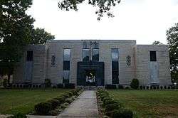 Howard County Courthouse in Nashville, Arkansas | |
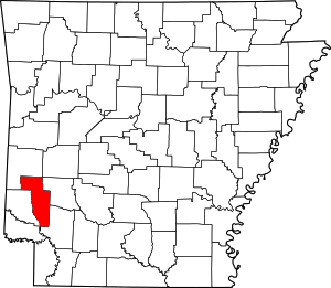 Location within the U.S. state of Arkansas | |
 Arkansas's location within the U.S. | |
| Coordinates: 34°08′10″N 93°59′14″W | |
| Country | |
| State | |
| Founded | April 17, 1873 |
| Seat | Nashville |
| Largest city | Nashville |
| Area | |
| • Total | 595 sq mi (1,540 km2) |
| • Land | 589 sq mi (1,530 km2) |
| • Water | 6.8 sq mi (18 km2) 1.1%% |
| Population (2010) | |
| • Total | 13,789 |
| • Estimate (2019) | 13,202 |
| • Density | 23/sq mi (8.9/km2) |
| Time zone | UTC−6 (Central) |
| • Summer (DST) | UTC−5 (CDT) |
| Congressional district | 4th |
Geography
According to the U.S. Census Bureau, the county has a total area of 595 square miles (1,540 km2), of which 589 square miles (1,530 km2) is land and 6.8 square miles (18 km2) (1.1%) is water.[4]
Major highways


Adjacent counties
- Polk County (north)
- Pike County (east)
- Hempstead County (southeast)
- Little River County (southwest)
- Sevier County (west)
National protected area
- Ouachita National Forest (part)
Demographics
| Historical population | |||
|---|---|---|---|
| Census | Pop. | %± | |
| 1880 | 9,917 | — | |
| 1890 | 13,789 | 39.0% | |
| 1900 | 14,076 | 2.1% | |
| 1910 | 16,898 | 20.0% | |
| 1920 | 18,565 | 9.9% | |
| 1930 | 17,489 | −5.8% | |
| 1940 | 16,621 | −5.0% | |
| 1950 | 13,342 | −19.7% | |
| 1960 | 10,878 | −18.5% | |
| 1970 | 11,412 | 4.9% | |
| 1980 | 13,459 | 17.9% | |
| 1990 | 13,569 | 0.8% | |
| 2000 | 14,300 | 5.4% | |
| 2010 | 13,789 | −3.6% | |
| Est. 2019 | 13,202 | [5] | −4.3% |
| U.S. Decennial Census[6] 1790–1960[7] 1900–1990[8] 1990–2000[9] 2010–2016[1] | |||
As of the 2000 census,[11] there were 14,300 people, 5,471 households, and 3,922 families residing in the county. The population density was 24 people per square mile (9/km²). There were 6,297 housing units at an average density of 11 per square mile (4/km²). The racial makeup of the county was 73.60% White, 21.86% Black or African American, 0.41% Native American, 0.50% Asian, 0.01% Pacific Islander, 2.76% from other races, and 0.86% from two or more races. 5.08% of the population were Hispanic or Latino of any race. 4.75% reported speaking Spanish at home, while 1.73% speak German.[12]
There were 5,471 households out of which 34.10% had children under the age of 18 living with them, 55.20% were married couples living together, 12.70% had a female householder with no husband present, and 28.30% were non-families. 25.70% of all households were made up of individuals and 12.60% had someone living alone who was 65 years of age or older. The average household size was 2.55 and the average family size was 3.04.
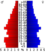
In the county, the population was spread out with 26.90% under the age of 18, 8.60% from 18 to 24, 27.80% from 25 to 44, 21.60% from 45 to 64, and 15.10% who were 65 years of age or older. The median age was 36 years. For every 100 females there were 95.10 males. For every 100 females age 18 and over, there were 91.20 males.
The median income for a household in the county was $28,699, and the median income for a family was $34,510. Males had a median income of $28,086 versus $17,266 for females. The per capita income for the county was $15,586. About 11.90% of families and 15.50% of the population were below the poverty line, including 20.10% of those under age 18 and 17.00% of those age 65 or over.
Government
Over the past few election cycles, Howard County has trended heavily towards the GOP. The last Democratic presidential candidate (as of 2016) to carry this county was Bill Clinton in 1996.
| Year | GOP | Dem | Others |
|---|---|---|---|
| 2016 | 67.54% 3,157 | 28.90% 1,351 | 3.55% 166 |
| 2012 | 64.81% 2,892 | 32.97% 1,471 | 2.22% 99 |
| 2008 | 61.02% 2,957 | 36.03% 1,746 | 2.95% 143 |
| 2004 | 55.35% 2,736 | 43.82% 2,166 | 0.83% 41 |
| 2000 | 52.16% 2,326 | 46.27% 2,063 | 1.57% 70 |
| 1996 | 31.91% 1,478 | 59.18% 2,741 | 8.92% 413 |
| 1992 | 34.73% 1,728 | 55.56% 2,764 | 9.71% 483 |
| 1988 | 57.87% 2,510 | 41.92% 1,818 | 0.21% 9 |
| 1984 | 63.72% 3,079 | 36.13% 1,746 | 0.14% 7 |
| 1980 | 47.12% 2,386 | 50.63% 2,564 | 2.25% 114 |
| 1976 | 32.94% 1,575 | 67.06% 3,207 | |
| 1972 | 71.50% 2,682 | 28.50% 1,069 | 0.00% 0 |
| 1968 | 32.09% 1,286 | 26.48% 1,061 | 41.43% 1,660 |
| 1964 | 53.84% 1,649 | 43.10% 1,320 | 3.07% 94 |
| 1960 | 44.79% 1,225 | 49.95% 1,366 | 5.27% 144 |
| 1956 | 47.72% 1,329 | 51.27% 1,428 | 1.01% 28 |
| 1952 | 38.64% 944 | 61.07% 1,492 | 0.29% 7 |
| 1948 | 12.05% 199 | 75.67% 1,250 | 12.29% 203 |
| 1944 | 27.20% 576 | 72.62% 1,538 | 0.19% 4 |
| 1940 | 21.24% 419 | 78.05% 1,540 | 0.71% 14 |
| 1936 | 16.02% 275 | 83.69% 1,437 | 0.29% 5 |
| 1932 | 8.82% 165 | 91.02% 1,703 | 0.16% 3 |
| 1928 | 41.76% 763 | 57.74% 1,055 | 0.49% 9 |
| 1924 | 23.12% 338 | 65.25% 954 | 11.63% 170 |
| 1920 | 44.94% 1,208 | 54.02% 1,452 | 1.04% 28 |
| 1916 | 29.27% 545 | 70.73% 1,317 | 0.00% 0 |
| 1912 | 24.06% 321 | 56.97% 760 | 18.97% 253 |
| 1908 | 35.24% 610 | 55.86% 967 | 8.90% 154 |
| 1904 | 39.03% 500 | 50.27% 644 | 10.69% 137 |
| 1900 | 36.22% 585 | 61.05% 986 | 2.72% 44 |
| 1896 | 17.41% 294 | 82.42% 1,392 | 0.18% 3 |
Communities
Cities
- Dierks
- Mineral Springs
- Nashville (county seat)
Towns
Historic communities
Townships
Townships in Arkansas are the divisions of a county. Each township includes unincorporated areas; some may have incorporated cities or towns within part of their boundaries. Arkansas townships have limited purposes in modern times. However, the United States Census does list Arkansas population based on townships (sometimes referred to as "county subdivisions" or "minor civil divisions"). Townships are also of value for historical purposes in terms of genealogical research. Each town or city is within one or more townships in an Arkansas county based on census maps and publications. The townships of Howard County are listed below; listed in parentheses are the cities, towns, and/or census-designated places that are fully or partially inside the township. [14][15]
- Blackland
- Blue Bayou
- Blue Ridge
- Brewer
- Buck Range
- Burg
- Center Point
- Clay
- County Line
- Dillard
- Duckett
- Franklin
- Holly Creek
- Madison (Dierks)
- Mineral Springs (Mineral Springs)
- Mountain
- Muddy Fork
- Nashville (Nashville)
- Saline
- Saratoga
- Tollette (Tollette) --- township completely inside Blackland Township
- Umpire
See also
- List of lakes in Howard County, Arkansas
- National Register of Historic Places listings in Howard County, Arkansas
References
- "State & County QuickFacts". United States Census Bureau. Archived from the original on June 7, 2011. Retrieved May 21, 2014.
- "Find a County". National Association of Counties. Archived from the original on 2011-05-31. Retrieved 2011-06-07.
- Gannett, Henry (1905). The Origin of Certain Place Names in the United States. Govt. Print. Off. pp. 162.
- "2010 Census Gazetteer Files". United States Census Bureau. August 22, 2012. Retrieved August 26, 2015.
- "Population and Housing Unit Estimates". Retrieved September 28, 2019.
- "U.S. Decennial Census". United States Census Bureau. Retrieved August 26, 2015.
- "Historical Census Browser". University of Virginia Library. Retrieved August 26, 2015.
- Forstall, Richard L., ed. (March 27, 1995). "Population of Counties by Decennial Census: 1900 to 1990". United States Census Bureau. Retrieved August 26, 2015.
- "Census 2000 PHC-T-4. Ranking Tables for Counties: 1990 and 2000" (PDF). United States Census Bureau. April 2, 2001. Retrieved August 26, 2015.
- Based on 2000 census data
- "U.S. Census website". United States Census Bureau. Retrieved 2011-05-14.
- "Language Map Data Center". www.mla.org. Retrieved 2018-08-28.
- "Dave Leip's Atlas of U.S. Presidential Elections". Retrieved November 18, 2016.
- 2011 Boundary and Annexation Survey (BAS): Howard County, AR (PDF) (Map). U. S. Census Bureau. Archived from the original (PDF) on 2012-10-19. Retrieved 2011-08-23.
- "Arkansas: 2010 Census Block Maps - County Subdivision". United States Census Bureau. Retrieved May 29, 2014.
Places adjacent to Howard County, Arkansas | ||||||||||
|---|---|---|---|---|---|---|---|---|---|---|
| ||||||||||
Municipalities and communities of Howard County, Arkansas, United States | ||
|---|---|---|
| Cities | Map of Arkansas highlighting Howard County | |
| Town | ||
| Unincorporated communities | ||
| Ghost towns | ||

| Authority control |
|
|---|