Polk County, Arkansas
Polk County is a county located in the U.S. state of Arkansas. As of the 2010 census, the population was 20,662.[1] The county seat is Mena.[2] Polk County is Arkansas's 48th county, formed on November 30, 1844, and named for James Polk, President of the United States. It is an alcohol prohibition or dry county.
Polk County | |
|---|---|
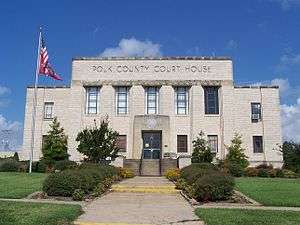 Polk County Courthouse in Mena | |
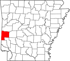 Location within the U.S. state of Arkansas | |
 Arkansas's location within the U.S. | |
| Coordinates: 34°30′07″N 94°14′27″W | |
| Country | |
| State | |
| Founded | November 30, 1844 |
| Named for | James K. Polk |
| Seat | Mena |
| Largest city | Mena |
| Area | |
| • Total | 862 sq mi (2,230 km2) |
| • Land | 858 sq mi (2,220 km2) |
| • Water | 4.8 sq mi (12 km2) 0.6%% |
| Population (2010) | |
| • Total | 20,662 |
| • Estimate (2019) | 19,964 |
| • Density | 24/sq mi (9.3/km2) |
| Time zone | UTC−6 (Central) |
| • Summer (DST) | UTC−5 (CDT) |
| Congressional district | 4th |
Geography
According to the U.S. Census Bureau, the county has a total area of 862 square miles (2,230 km2), of which 858 square miles (2,220 km2) is land and 4.8 square miles (12 km2) (0.6%) is water.[3]
Major highways
.svg.png)


Adjacent counties
- Scott County (north)
- Montgomery County (east)
- Howard County (southeast)
- Sevier County (south)
- McCurtain County, Oklahoma (southwest)
- Le Flore County, Oklahoma (northwest)
National protected area
- Ouachita National Forest (part)
Demographics
| Historical population | |||
|---|---|---|---|
| Census | Pop. | %± | |
| 1850 | 1,263 | — | |
| 1860 | 4,262 | 237.5% | |
| 1870 | 3,376 | −20.8% | |
| 1880 | 5,857 | 73.5% | |
| 1890 | 9,283 | 58.5% | |
| 1900 | 18,352 | 97.7% | |
| 1910 | 17,216 | −6.2% | |
| 1920 | 16,412 | −4.7% | |
| 1930 | 14,857 | −9.5% | |
| 1940 | 15,832 | 6.6% | |
| 1950 | 14,182 | −10.4% | |
| 1960 | 11,981 | −15.5% | |
| 1970 | 13,297 | 11.0% | |
| 1980 | 17,007 | 27.9% | |
| 1990 | 17,347 | 2.0% | |
| 2000 | 20,229 | 16.6% | |
| 2010 | 20,662 | 2.1% | |
| Est. 2019 | 19,964 | [4] | −3.4% |
| U.S. Decennial Census[5] 1790–1960[6] 1900–1990[7] 1990–2000[8] 2010–2016[1] | |||
As of the 2000 census,[10] there were 20,229 people, 8,047 households, and 5,793 families residing in the county. The population density was 24 people per square mile (9/km2). There were 9,236 housing units at an average density of 11 per square mile (4/km2). The racial makeup of the county was 94.69% White, 0.16% Black or African American, 1.49% Native American, 0.21% Asian, 0.06% Pacific Islander, 1.72% from other races, and 1.67% from two or more races. 3.50% of the population were Hispanic or Latino of any race.
There were 8,047 households, out of which 31.90% had children under the age of 18 living with them, 60.40% were married couples living together, 8.40% had a female householder with no husband present, and 28.00% were non-families. 25.00% of all households were made up of individuals, and 12.30% had someone living alone who was 65 years of age or older. The average household size was 2.49 and the average family size was 2.97.
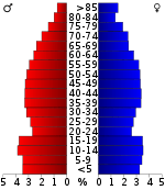
In the county, the population was spread out, with 25.60% under the age of 18, 7.90% from 18 to 24, 25.00% from 25 to 44, 24.50% from 45 to 64, and 17.00% who were 65 years of age or older. The median age was 39 years. For every 100 females there were 97.00 males. For every 100 females age 18 and over, there were 94.00 males.
The median income for a household in the county was $25,180, and the median income for a family was $31,379. Males had a median income of $23,397 versus $17,294 for females. The per capita income for the county was $14,063. 18.20% of the population and 14.00% of families were below the poverty line. Out of the total people living in poverty, 23.50% were under the age of 18 and 16.20% were 65 or older.
As of 2010 Polk County had a population of 20,662. Of this population 89.77% were non-Hispanic whites, 0.31% were blacks, 1.76% Native Americans, 0.45% Asians, 2.03% non-Hispanics reporting one or more race and 5.76% Hispanic or Latino.
Government
Over the past few election cycles Polk County has trended heavily towards the GOP. The last Democrat (as of 2016) to carry this county was Bill Clinton in 1992.
| Year | GOP | Dem | Others |
|---|---|---|---|
| 2016 | 80.40% 6,618 | 14.72% 1,212 | 4.87% 401 |
| 2012 | 77.08% 5,955 | 20.14% 1,556 | 2.78% 215 |
| 2008 | 71.25% 5,473 | 25.48% 1,957 | 3.27% 251 |
| 2004 | 66.57% 5,192 | 31.71% 2,473 | 1.72% 134 |
| 2000 | 63.95% 4,600 | 32.18% 2,315 | 3.87% 278 |
| 1996 | 42.70% 2,852 | 42.28% 2,824 | 15.02% 1,003 |
| 1992 | 38.20% 2,757 | 43.81% 3,162 | 17.98% 1,298 |
| 1988 | 62.15% 4,099 | 36.24% 2,390 | 1.61% 106 |
| 1984 | 70.15% 5,181 | 28.45% 2,101 | 1.41% 104 |
| 1980 | 58.51% 3,993 | 38.35% 2,617 | 3.14% 214 |
| 1976 | 40.76% 2,432 | 58.75% 3,505 | 0.49% 29 |
| 1972 | 74.83% 3,609 | 23.22% 1,120 | 1.95% 94 |
| 1968 | 40.30% 2,094 | 24.83% 1,290 | 34.87% 1,812 |
| 1964 | 43.88% 2,022 | 55.88% 2,575 | 0.24% 11 |
| 1960 | 51.82% 1,882 | 45.02% 1,635 | 3.17% 115 |
| 1956 | 58.29% 1,832 | 40.95% 1,287 | 0.76% 24 |
| 1952 | 55.91% 1,756 | 43.90% 1,379 | 0.19% 6 |
| 1948 | 25.89% 554 | 66.21% 1,417 | 7.89% 169 |
| 1944 | 43.09% 764 | 56.35% 999 | 0.56% 10 |
| 1940 | 31.49% 585 | 67.55% 1,255 | 0.97% 18 |
| 1936 | 30.95% 537 | 67.44% 1,170 | 1.61% 28 |
| 1932 | 11.90% 223 | 83.67% 1,568 | 4.43% 83 |
| 1928 | 53.34% 1,022 | 45.41% 870 | 1.25% 24 |
| 1924 | 31.49% 502 | 54.14% 863 | 14.37% 229 |
| 1920 | 46.27% 1,173 | 47.65% 1,208 | 6.07% 154 |
| 1916 | 26.51% 448 | 73.49% 1,242 | 0.00% 0 |
| 1912 | 11.08% 162 | 47.47% 694 | 41.45% 606 |
| 1908 | 37.88% 628 | 49.70% 824 | 12.42% 206 |
| 1904 | 40.44% 476 | 44.86% 528 | 14.70% 173 |
| 1900 | 29.63% 411 | 66.47% 922 | 3.89% 54 |
| 1896 | 4.78% 51 | 94.10% 1,004 | 1.12% 12 |
Popular culture
Polk County is the setting for Stephen Hunter's fictional Bob Lee Swagger series, the most notable being Black Light, as well as the place where Joel B Reed's fictional character, Jazz Phillips, of the Jazz Phillips mystery series, grew up.
Communities
Towns
Unincorporated community
Townships
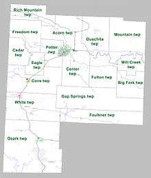
Townships in Arkansas are the divisions of a county. Each township includes unincorporated areas; some may have incorporated cities or towns within part of their boundaries. Arkansas townships have limited purposes in modern times. However, the United States Census does list Arkansas population based on townships (sometimes referred to as "county subdivisions" or "minor civil divisions"). Townships are also of value for historical purposes in terms of genealogical research. Each town or city is within one or more townships in an Arkansas county based on census maps and publications. The townships of Polk County are listed below; listed in parentheses are the cities, towns, and/or census-designated places that are fully or partially inside the township. [12][13]
See also
- List of lakes in Polk County, Arkansas
- National Register of Historic Places listings in Polk County, Arkansas
- Osro Cobb
- KX197
References
- "State & County QuickFacts". United States Census Bureau. Archived from the original on January 5, 2016. Retrieved May 19, 2014.
- "Find a County". National Association of Counties. Retrieved 2011-06-07.
- "2010 Census Gazetteer Files". United States Census Bureau. August 22, 2012. Retrieved August 27, 2015.
- "Population and Housing Unit Estimates". Retrieved September 28, 2019.
- "U.S. Decennial Census". United States Census Bureau. Retrieved August 27, 2015.
- "Historical Census Browser". University of Virginia Library. Retrieved August 27, 2015.
- Forstall, Richard L., ed. (March 27, 1995). "Population of Counties by Decennial Census: 1900 to 1990". United States Census Bureau. Retrieved August 27, 2015.
- "Census 2000 PHC-T-4. Ranking Tables for Counties: 1990 and 2000" (PDF). United States Census Bureau. April 2, 2001. Retrieved August 27, 2015.
- Based on 2000 census data
- "U.S. Census website". United States Census Bureau. Retrieved 2011-05-14.
- "Dave Leip's Atlas of U.S. Presidential Elections". Retrieved November 18, 2016.
- 2011 Boundary and Annexation Survey (BAS): Polk County, AR (PDF) (Map). U. S. Census Bureau. Archived from the original (PDF) on 2012-10-19. Retrieved 2011-08-12.
- "Arkansas: 2010 Census Block Maps - County Subdivision". United States Census Bureau. Retrieved May 29, 2014.
External links
- Polk County, Arkansas entry on the Encyclopedia of Arkansas History & Culture
Places adjacent to Polk County, Arkansas | ||||||||||
|---|---|---|---|---|---|---|---|---|---|---|
| ||||||||||
Municipalities and communities of Polk County, Arkansas, United States | ||
|---|---|---|
| Cities | Map of Arkansas highlighting Polk County | |
| Towns | ||
| Unincorporated communities | ||

| Authority control |
|
|---|