Interstate 40 in Arkansas
Interstate 40 (I-40) is an east–west Interstate Highway that has a 284.69-mile (458.16 km) section in the U.S. state of Arkansas connecting Oklahoma to Tennessee. The route enters Arkansas from the west just north of the Arkansas River near Dora. It travels eastward across the northern portion of the state connecting the cities of Fort Smith, Clarksville, Russellville, Morrilton, Conway, North Little Rock, Forrest City, and West Memphis. I-40 continues into Tennessee heading through Memphis. The highway has major junctions with Interstate 540 at Van Buren (the main highway connecting to Fort Smith), Interstate 49 at Alma (the main highway connecting to Fayetteville and Bentonville), Interstate 30 in North Little Rock (the Interstate linking south to Texarkana and Dallas, Texas), and Interstate 55 to Blytheville.
| ||||
|---|---|---|---|---|
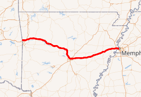
I-40 highlighted in red | ||||
| Route information | ||||
| Maintained by ArDOT | ||||
| Length | 284.69 mi[1] (458.16 km) | |||
| Major junctions | ||||
| West end | ||||
| East end | ||||
| Location | ||||
| Counties | Crawford, Franklin, Johnson, Pope, Conway, Faulkner, Pulaski, Lonoke, Prairie, Monroe, St. Francis, Crittenden | |||
| Highway system | ||||
| ||||
.svg.png)
For the majority of its routing through Arkansas, I-40 follows the historic alignment of two separate United States highways. From Oklahoma to Little Rock, Interstate 40 generally follows U.S. Route 64 through the Ozark Mountains. East of Little Rock, the route generally follows the routing of U.S. Route 70 until the Tennessee state line.
Route description
Oklahoma to Little Rock
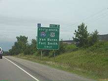
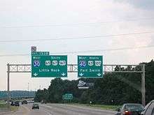
I-40 enters Arkansas from Oklahoma at Dora in Crawford County.[2] It heads east into Van Buren, giving access to Fort Smith as well across the Arkansas River to the south. Access is primarily via Interstate 540/US 71, which was built as a southern spur to Fort Smith in the 1970s. I-40 overlaps with US 71, forming a concurrency until the alignment of Interstate 49 breaks north to Fayetteville, Springdale, Rogers, Bentonville, and its northern Arkansas terminus in Bella Vista, with US 71 breaking away shortly afterwards at another interchange.[3][4] The route continues to parallel US 64 into the Ozark Mountains by entering Franklin County and providing access to the Pig Trail Scenic Byway in Ozark.[5] Interstate 40 runs through Clarksville (where it has a junction with US 64), passes over part of Lake Dardanelle, and meets Highway 7 in Russellville.[6][7] I 40 continues to the east through Morrilton before turning south to Conway and Faulkner County.[8][9] In Conway, I-40 forms a concurrency with US 65 at exit 125, which will continue until exit 153a in Little Rock. The highway also has another junction with US 64 and US 65 Business in Conway before passing Lake Conway and entering the Little Rock metropolitan area.[9]
Little Rock to Tennessee
Now in Pulaski County, I-40 heads towards the south-southeast as it heads to the town of Maumelle. It continues towards this direction until it reaches Interstate 430, which provides access along the western side of Little Rock.[10] Further southeast near the Arkansas River, the route has a high volume interchange as the northern terminus of Interstate 30 as well as concurrent routes with US 67/US 167; US 65 turns south at this intersection, breaking the concurrency formed in Conway.[10] I-40 (now concurrent with US 67 and US 167) continues east for 1.5 miles (2.4 km) before the US 67/US 167 concurrency turns north as a separate northeasterly expressway.[10] From this point onward, Interstate 40 begins to parallel US 70 rather than US 64, which was a more or less a parallel route until Conway. The interstate continues to the east to intersect the concurrency of I-440/AR 440 before entering Lonoke County.[10] Passing through Lonoke, the route runs through rural Arkansas with straight alignments and relatively few junctions, forming an overlap with US 63 in Hazen and meeting US 49/AR 17 in Brinkley.[11][12][12][13] Upon entering St. Francis County, Interstate 40 runs northeast to Forrest City, where it intersects with Highway 1.[14] Continuing northeast, I-40 enters Crittenden County, where it intersects with US 79 at Shearerville and enters West Memphis.[15]
The highway continues to the northeast to an interchange with Interstate 55, which form a concurrency east for 3.1 miles (5.0 km). I-40 continues east onto the Hernando De Soto Bridge over the Mississippi River. The Tennessee border is at the midpoint of the river, and Memphis, Tennessee begins at the east side of the bridge.[15]
History
Exit list
| County | Location | mi | km | Exit | Destinations | Notes |
|---|---|---|---|---|---|---|
| Crawford | Fort Smith | 0.00 | 0.00 | Continuation into Oklahoma | ||
| 0.03– 0.70 | 0.048– 1.13 | 1 | Dora, Fort Smith | Westbound exit and eastbound entrance | ||
| Van Buren | 3.12 | 5.02 | 3 | Lee Creek Road | ||
| 5.26 | 8.47 | 5 | ||||
| 7.35 | 11.83 | 7 | Western end of US 71 concurrency; I-540 south to US 271; I-540 exits 0A-B, northern terminus; tri-stack interchange. | |||
| Alma | 12.26 | 19.73 | 12 | I-49 to I-40 east exit 20; temporary southern end of I-49 segment; to use AR 549 freeway in Fort Smith; I-49 south to Texarkana not yet built besides AR 549. Former northern branch of I-540 | ||
| 13.25 | 21.32 | 13 | Eastern end of US 71 concurrency | |||
| Mulberry | 20.00 | 32.19 | 20 | Dyer, Mulberry | ||
| 23.95 | 38.54 | 24 | ||||
| Franklin | Ozark | 34.52 | 55.55 | 35 | ||
| 37.26 | 59.96 | 37 | ||||
| Wiederkehr Village | 40.83 | 65.71 | 41 | |||
| Johnson | | 46.40 | 74.67 | 47 | ||
| Clarksville | 54.70 | 88.03 | 55 | |||
| 57.01 | 91.75 | 57 | Crawford Street | |||
| 58.05 | 93.42 | 58 | ||||
| Lamar | 63.68 | 102.48 | 64 | |||
| Knoxville | 66.47 | 106.97 | 67 | |||
| Pope | London | 73.84 | 118.83 | 74 | ||
| 77.61 | 124.90 | 78 | ||||
| Russellville | 80.90 | 130.20 | 81 | Arkansas Scenic 7 Byway | ||
| 82.99 | 133.56 | 83 | ||||
| 83.97 | 135.14 | 84 | ||||
| Pottsville | 87.99 | 141.61 | 88 | |||
| Atkins | 93.71 | 150.81 | 94 | |||
| Conway | | 100.53 | 161.79 | 101 | Blackwell | |
| Morrilton | 106.33 | 171.12 | 107 | |||
| 107.83 | 173.54 | 108 | ||||
| Plumerville | 112.33 | 180.78 | 112 | |||
| Menifee | 117.37 | 188.89 | 117 | Menifee | ||
| Faulkner | Conway | 123.40 | 198.59 | 124 | As of May 1, 2008 this exit now includes on-ramps and off-ramps in both directions. | |
| 124.94 | 201.07 | 125 | Western end of US 65 concurrency | |||
| 126.59 | 203.73 | 127 | ||||
| 128.53 | 206.85 | 129 | Signed as exits 129A (east) and 129B (north/west) westbound | |||
| Gold Creek | 132.14 | 212.66 | 132 | |||
| Mayflower | 135.27 | 217.70 | 135 | |||
| Pulaski | | 142.17 | 228.80 | 142 | ||
| North Little Rock | 147.18– 147.42 | 236.86– 237.25 | 147 | I-430 exits 13A-B | ||
| 148.01 | 238.20 | 148 | ||||
| 150.16 | 241.66 | 150 | Burns Park | |||
| 151.85 | 244.38 | 152 | Eastbound exit and westbound entrance | |||
| 151.91 | 244.48 | 152A | Westbound exit and eastbound entrance | |||
| 152.70 | 245.75 | 153A | No eastbound entrance from northbound JFK Boulevard; southern terminus of AR 107 | |||
| 153.02 | 246.26 | 153B | Eastern terminus of I-30; eastern end of US 65 concurrency; western end of US 67/US 167 concurrency; I-30 exits 143A-B; left exit westbound. | |||
| 154.11 | 248.02 | 154 | Lakewood | Eastbound exit and westbound entrance | ||
| 154.61 | 248.82 | 155 | Eastern end of US 67/US 167 concurrency; future southern terminus of I-57 | |||
| 155.55 | 250.33 | 156 | Springhill Drive — Baptist Health Medical Center-NLR | |||
| 156.32 | 251.57 | 157 | ||||
| 158.73 | 255.45 | 159 | I-440 exits 11A-B. | |||
| 160.60 | 258.46 | 161 | ||||
| Lonoke | | 164.58 | 264.87 | 165 | Kerr Road | |
| | 168.35 | 270.93 | 169 | |||
| Lonoke | 172.87 | 278.21 | 173 | |||
| 174.35 | 280.59 | 175 | ||||
| Carlisle | 182.25 | 293.30 | 183 | |||
| Prairie | Hazen | 192.93 | 310.49 | 193 | Western end of US 63 concurrency | |
| | 201.91 | 324.94 | 202 | |||
| Monroe | Brinkley | 215.42 | 346.68 | 216 | ||
| St. Francis | Wheatley | 220.70 | 355.18 | 221 | ||
| Palestine | 232.88 | 374.78 | 233 | |||
| | 238.72 | 384.18 | 239 | |||
| Forrest City | 240.40 | 386.89 | 241 | Signed as exits 241A (south) and 241B (north) | ||
| 241.42 | 388.53 | 242 | ||||
| | 246.70 | 397.03 | 247 | |||
| | 255.86 | 411.77 | 256 | |||
| | 259.51 | 417.64 | 260 | |||
| Crittenden | Jennette | 264.67 | 425.95 | 265 | ||
| West Memphis | 270.78 | 435.78 | 271 | |||
| 274.81 | 442.26 | 275 | ||||
| 276.14 | 444.40 | 276 | Eastbound exit only | |||
| 276.70 | 445.31 | 277 | Eastern end of US 63 concurrency; western end of I-55/US 61/US 64 concurrency, south exit 8 | |||
| 277.22 | 446.14 | 278 | ||||
| 279.11 | 449.18 | 5 | Ingram Boulevard | Exit number follows I-55; provides access for motorists merging onto I-40 from I-55 | ||
| 279.37 | 449.60 | 279B | Eastern end of I-55/US 61/US 64 concurrency, north exit 5; eastbound exit and westbound entrance | |||
| 278.97 | 448.96 | 279A | Ingram Boulevard | |||
| 280.18 | 450.91 | 280 | Dr. Martin Luther King Junior Drive | |||
| 280.68 | 451.71 | 281 | Westbound exit and eastbound entrance | |||
| 284.03 | 457.10 | Hernando de Soto Bridge crossing; Tennessee state line | ||||
1.000 mi = 1.609 km; 1.000 km = 0.621 mi
| ||||||
References
- Planning and Research Division (2010). "Arkansas Road Log Database". Arkansas State Highway and Transportation Department. Archived from the original (Database) on June 23, 2011. Retrieved June 9, 2011.
- General Highway Map, Crawford County, Arkansas (PDF) (Map). 1:62500. Cartography by Planning and Research Division. Arkansas State Highway and Transportation Department. 2011. Retrieved November 15, 2011.
- General Highway Map, Washington County, Arkansas (PDF) (Map). 1:62500. Cartography by Planning and Research Division. Arkansas State Highway and Transportation Department. 2010. Retrieved November 15, 2011.
- General Highway Map, Benton County, Arkansas (PDF) (Map). 1:62500. Cartography by Planning and Research Division. Arkansas State Highway and Transportation Department. 2010. Retrieved November 15, 2011.
- General Highway Map, Franklin County, Arkansas (PDF) (Map). 1:62500. Cartography by Planning and Research Division. Arkansas State Highway and Transportation Department. 2011. Retrieved November 15, 2011.
- General Highway Map, Johnson County, Arkansas (PDF) (Map). 1:62500. Cartography by Planning and Research Division. Arkansas State Highway and Transportation Department. 2010. Retrieved November 15, 2011.
- General Highway Map, Pope County, Arkansas (PDF) (Map). 1:62500. Cartography by Planning and Research Division. Arkansas State Highway and Transportation Department. 2006. Retrieved November 15, 2011.
- General Highway Map, Conway County, Arkansas (PDF) (Map). 1:62500. Cartography by Planning and Research Division. Arkansas State Highway and Transportation Department. 2008. Retrieved November 15, 2011.
- General Highway Map, Faulkner County, Arkansas (PDF) (Map). 1:62500. Cartography by Planning and Research Division. Arkansas State Highway and Transportation Department. 2009. Retrieved November 15, 2011.
- General Highway Map, Pulaski County, Arkansas (PDF) (Map). 1:62500. Cartography by Planning and Research Division. Arkansas State Highway and Transportation Department. 2009. Retrieved November 15, 2011.
- General Highway Map, Lonoke County, Arkansas (PDF) (Map). 1:62500. Cartography by Planning and Research Division. Arkansas State Highway and Transportation Department. 2010. Retrieved November 15, 2011.
- General Highway Map, Prairie County, Arkansas (PDF) (Map). 1:62500. Cartography by Planning and Research Division. Arkansas State Highway and Transportation Department. 2008. Retrieved November 15, 2011.
- General Highway Map, Monroe County, Arkansas (PDF) (Map). 1:62500. Cartography by Planning and Research Division. Arkansas State Highway and Transportation Department. 2009. Retrieved November 15, 2011.
- General Highway Map, St. Francis County, Arkansas (PDF) (Map). 1:62500. Cartography by Planning and Research Division. Arkansas State Highway and Transportation Department. 2007. Retrieved November 15, 2011.
- General Highway Map, Crittenden County, Arkansas (PDF) (Map). 1:62500. Cartography by Planning and Research Division. Arkansas State Highway and Transportation Department. 2009. Retrieved November 15, 2011.
External links
![]()
| Previous state: Oklahoma |
Arkansas | Next state: Tennessee |