Arkansas Highway 980
Highway 980 (AR 980, Ark. 980, and Hwy. 980) is a state highway designation for all state maintained airport roads in Arkansas.[1]
| ||||
|---|---|---|---|---|
| Route information | ||||
| Maintained by AHTD | ||||
| Highway system | ||||
| ||||
.svg.png)
List of routes
Arkansas County
Almyra
| |
|---|---|
| Location | Almyra Municipal Airport, Almyra |
| Length | 2.78 mi[1] (4.47 km) |
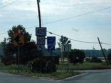
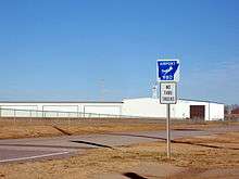
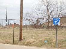
Arkansas Highway 980 is a state highway of 2.78 miles (4.47 km) in Arkansas County.[1] It connects Arkansas Highway 130 with Almyra Municipal Airport in Almyra.[2]
Section 2
| |
|---|---|
| Location | De Witt Municipal Airport, De Witt |
| Length | 1.93 mi[1] (3.11 km) |
Arkansas Highway 980 is a state highway of 1.93 miles (3.11 km) in Arkansas County.[1] It connects U.S. Route 165 with De Witt Municipal Airport in south De Witt.[2]
Benton County
| |
|---|---|
| Location | Smith Field, Siloam Springs |
| Length | 0.20 mi[1] (0.32 km) |
Arkansas Highway 980 is a state highway of 0.20 miles (0.32 km) in Benton County.[1] It connects AR 59 with Smith Field in Siloam Springs.[3]
Boone County
| |
|---|---|
| Location | Boone County Airport, Harrison |
| Length | 0.45 mi[1] (0.72 km) |
Arkansas Highway 980 is a state highway of 0.45 miles (0.72 km) in Boone County.[1] It connects US 62/US 65 with the Boone County Airport in Harrison.[4]
Bradley County
| |
|---|---|
| Location | Warren Municipal Airport, Warren |
| Length | 0.52 mi[1] (0.84 km) |
Arkansas Highway 980 is a state highway of 0.52 miles (0.84 km) in Bradley County.[1] It connects US 63/AR 8 with the Warren Municipal Airport south of Warren.[5]
Carroll County
| |
|---|---|
| Location | Carroll County Airport Berryville |
| Length | 0.60 mi[1] (0.97 km) |
Arkansas Highway 980 is a state highway of 0.60 miles (0.97 km) in Carroll County.[1] It connects US 62 with the Carroll County Airport near Berryville.[6]
Chicot County
Section 1
| |
|---|---|
| Location | Dermott Municipal Airport, Dermott |
| Length | 0.22 mi[1] (0.35 km) |
Arkansas Highway 980 is a state highway of 0.22 miles (0.35 km) in Chicot County.[1] It connects US 165 with the Dermott Municipal Airport near Dermott.[7]
Section 2
| |
|---|---|
| Location | Lake Village Municipal Airport, Lake Village |
| Length | 1.70 mi[1] (2.74 km) |
Arkansas Highway 980 is a state highway of 1.70 miles (2.74 km) in Chicot County.[1] It connects US 65 with the Lake Village Municipal Airpott Municipal Airport near Lake Village.[7]
Clay County
Section 1
| |
|---|---|
| Location | Corning Municipal Airport, Berryville |
| Length | 0.41 mi[1] (0.66 km) |
Arkansas Highway 980 is a state highway of 0.41 miles (0.66 km) in Clay County.[1] It connects US 62/US 67 (Future I-57) with the Corning Municipal Airport near Corning.[8]
Section 2
| |
|---|---|
| Location | Rector Airport, Rector |
| Length | 0.31 mi[1] (0.50 km) |
Arkansas Highway 980 is a state highway of 0.31 miles (0.50 km) in Clay County.[1] It connects US 49/AR 1 with the Rector Airport near Rector.[8]
Cleburne County
| |
|---|---|
| Location | Heber Springs Municipal Airport, Heber Springs |
| Length | 0.36 mi[1] (0.58 km) |
Arkansas Highway 980 is a state highway of 0.36 miles (0.58 km) in Cleburne County.[1] It connects Arkansas Highway 210 with the Heber Springs Municipal Airport in Heber Springs.[9]
Columbia County
| |
|---|---|
| Location | Magnolia Municipal Airport |
| Length | 0.66 mi[1] (1.06 km) |
Arkansas Highway 980 is a state highway of 0.66 miles (1.06 km) in Columbia County.[1] The route connects U.S. Route 79 with Magnolia Municipal Airport south of Magnolia.[10]
Conway County
| |
|---|---|
| Location | Morrilton Airport, Morrilton |
| Length | 0.73 mi[1] (1.17 km) |
Arkansas Highway 980 is a state highway of 0.73 miles (1.17 km) in Conway County.[1] It connects AR 9 with the Morrilton Airport in Morrilton.
Cross County
| |
|---|---|
| Location | Wynne Municipal Airport, Wynne |
| Length | 1.33 mi[1] (2.14 km) |
Arkansas Highway 980 is a state highway of 1.33 miles (2.14 km) in Cross County.[1] The route connects Arkansas Highway 1 with Wynne Municipal Airport in Wynne.[11]
Desha County
Section 1
| |
|---|---|
| Location | McGehee Municipal Airport, McGehee |
| Length | 0.82 mi[1] (1.32 km) |
Arkansas Highway 980 is a state highway of 0.82 miles (1.32 km) in Desha County.[1] The route connects Arkansas Highway 4 with McGehee Municipal Airport in McGehee.[12] The route was shortened on January 7, 2009.[12]
Section 2
| |
|---|---|
| Location | Billy Free Municipal Airport |
| Length | 0.49 mi[1] (0.79 km) |
Arkansas Highway 980 is a state highway of 0.49 miles (0.79 km) in Desha County.[1] The route connects Arkansas Highway 54 with Billy Free Municipal Airport near Dumas.[12]
Drew County
| |
|---|---|
| Location | Monticello Municipal Airport, Monticello |
| Length | 0.50 mi[1] (0.80 km) |
Arkansas Highway 980 is a state highway of 0.50 miles (0.80 km) in Drew County.[1] The route connects U.S. Route 278 with Ellis Field in east Monticello.[13]
Fulton County
| |
|---|---|
| Location | Salem Airport, Salem |
| Length | 0.40 mi[1] (0.64 km) |
Arkansas Highway 980 is a state highway of 0.40 miles (0.64 km) in Fulton County.[1] It connects AR 9 with the Salem Airport in Salem.[14]
Howard County
| |
|---|---|
| Location | Howard County Airport |
| Length | 3.58 mi[1] (5.76 km) |
Arkansas Highway 980 is a state highway of 3.58 miles (5.76 km) in Howard County.[1] The route connects U.S. Route 371 with Howard County Airport north of Nashville.[15]
Lawrence County
| |
|---|---|
| Location | Walnut Ridge Regional Airport, College City |
| Length | 1.89 mi[1] (3.04 km) |
Arkansas Highway 980 is a state highway of 1.89 miles (3.04 km) in Lawrence County.[1] It connects US 67 with the Walnut Ridge Regional Airport in College City.[16]
Madison County
| |
|---|---|
| Location | Huntsville - Madison County Municipal Airport, Huntsville |
| Length | 1.13 mi[1] (1.82 km) |
Arkansas Highway 980 is a state highway of 1.13 miles (1.82 km) in Madison County.[1] It connects AR 74 with the Huntsville - Madison County Municipal Airport in Huntsville.[17]
Marion County
| |
|---|---|
| Location | Marion County Regional Airport, Flippin |
| Length | 1.17 mi[1] (1.88 km) |
Arkansas Highway 980 is a state highway of 1.17 miles (1.88 km) in Marion County.[1] It connects AR 178 with the Marion County Regional Airport in Flippin.[18]
Polk County
| |
|---|---|
| Location | Mena Intermountain Municipal Airport, Mena |
| Length | 0.36 mi[1] (0.58 km) |
Arkansas Highway 980 is a state highway of 0.4 miles (0.64 km) in Polk County.[1] It connects Arkansas Highway 8 with the Mena Intermountain Municipal Airport in Mena.[19]
Van Buren County
| |
|---|---|
| Location | Clinton Municipal Airport, Clinton |
| Length | 1.0 mi (1.6 km) |
Arkansas Highway 980 is a state highway of 1.0 mile (1.6 km) in Van Buren County. It connects AR 16 with the Clinton Municipal Airport in Clinton.
Former routing
| |
|---|---|
| Location | Ozark Regional Airport, Midway |
| Length | 0.20 mi (0.32 km) |
Arkansas Highway 980 was a state highway of 0.2 miles (0.32 km) in Baxter County. It connected AR 126 with Ozark Regional Airport in Midway.[20] It was removed from the State Highway system on April 27, 2007.[21]
References
- "[Arkansas] State Highways 2009 (Database)." April 2010. AHTD: Planning and Research Division. Database. Archived 2011-07-07 at the Wayback Machine. Retrieved November 30, 2010.
- "Arkansas County, Arkansas." Arkansas State Highway and Transportation Department. AHTD Arkansas County map Retrieved on November 30, 2010.
- "Benton County, Arkansas." Arkansas State Highway and Transportation Department. AHTD Benton County map Retrieved on July 12, 2010.
- "Boone County, Arkansas." Arkansas State Highway and Transportation Department. AHTD Boone County map Retrieved on July 12, 2010.
- "Bradley County, Arkansas." Arkansas State Highway and Transportation Department. AHTD Bradley County map Retrieved on November 30, 2010.
- "Carroll County, Arkansas." Arkansas State Highway and Transportation Department. AHTD Carroll County map Retrieved on July 12, 2010.
- "Chicot County, Arkansas." Arkansas State Highway and Transportation Department. AHTD Chicot County map Retrieved on November 30, 2010.
- "Clay County, Arkansas." Arkansas State Highway and Transportation Department. AHTD Clay County map Retrieved on July 13, 2010.
- "Cleburne County, Arkansas." Arkansas State Highway and Transportation Department. AHTD Cleburne County map Retrieved on November 30, 2010.
- "Columbia County, Arkansas." Arkansas State Highway and Transportation Department. AHTD Columbia County map Retrieved on November 30, 2010.
- "Cross County, Arkansas." Arkansas State Highway and Transportation Department. AHTD Cross County map Retrieved on November 30, 2010.
- "Desha County, Arkansas." Arkansas State Highway and Transportation Department. AHTD Desha County map Retrieved on November 30, 2010.
- "Drew County, Arkansas." Arkansas State Highway and Transportation Department. AHTD Drew County map Retrieved on November 30, 2010.
- "Fulton County, Arkansas." Arkansas State Highway and Transportation Department. AHTD Fulton County map Retrieved on July 13, 2010.
- "Howard County, Arkansas." Arkansas State Highway and Transportation Department. AHTD Howard County map Retrieved on November 30, 2010.
- "Lawrence County, Arkansas." Arkansas State Highway and Transportation Department. AHTD Lawrence County map Retrieved on July 13, 2010.
- "Madison County, Arkansas." Arkansas State Highway and Transportation Department. AHTD Madison County map Retrieved on July 13, 2010.
- "Marion County, Arkansas." Arkansas State Highway and Transportation Department. AHTD Marion County map Retrieved on July 12, 2010.
- "Polk County, Arkansas." Arkansas State Highway and Transportation Department. AHTD Polk County map Retrieved on April 14, 2014.
- "Baxter County, Arkansas." Arkansas State Highway and Transportation Department. AHTD Baxter County 2002 map Retrieved on November 30, 2010.
- Arkansas State Highway and Transportation Department. AHTD Baxter County map Retrieved on April 9, 2009.