Craighead County, Arkansas
Craighead County is a county located in the U.S. state of Arkansas. As of the 2010 census, the population was 96,443.[1] The county has two county seats — Jonesboro and Lake City.[2] Craighead County is Arkansas's 58th county, formed on February 19, 1859, and named for state Senator Thomas Craighead. It is one of several dry counties within the state of Arkansas, in which the sale of alcoholic beverages is largely prohibited.
Craighead County | |
|---|---|
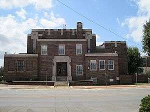 Craighead County Courthouse, Jonesboro | |
 Flag  Seal | |
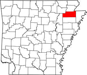 Location within the U.S. state of Arkansas | |
 Arkansas's location within the U.S. | |
| Coordinates: 35°50′25″N 90°42′27″W | |
| Country | |
| State | |
| Founded | February 19, 1859 |
| Named for | Thomas Craighead |
| Seat | Jonesboro (western district); Lake City (eastern district) |
| Largest city | Jonesboro |
| Area | |
| • Total | 713 sq mi (1,850 km2) |
| • Land | 707 sq mi (1,830 km2) |
| • Water | 5.5 sq mi (14 km2) 0.8%% |
| Population (2010) | |
| • Total | 96,443 |
| • Estimate (2019) | 110,332 |
| • Density | 140/sq mi (52/km2) |
| Time zone | UTC−6 (Central) |
| • Summer (DST) | UTC−5 (CDT) |
| Congressional district | 1st |
| Website | www |
Craighead County is included in the Jonesboro, AR Metropolitan Statistical Area.
History
Craighead County was part of the territory claimed for France on April 9, 1682 by René Robert Cavelier, Sieur de La Salle, who laid claim to all of the land drained by the Mississippi River and its tributaries. LaSalle's claim was named Louisiana in honor of Louis XIV, King of France.
The Treaty of Fontainebleau (1762) was signed between France and Spain and ownership of the Louisiana territory west of the Mississippi River was transferred to the Spanish crown as a result of the Seven Years' War and Craighead County became a Spanish possession.
Spain controlled of the territory encompassing the county until October 1, 1800 when Napoleon Bonaparte forced Spain to return the lost territories to France under the Treaty of Ildefonso. Napoleon maintained grandiose plans to establish a vast French Empire in Louisiana but the Royal Navy prevented him from transferring troops or settlers to the acquired territories.
Fear was high in the United States that Napoleon would attempt to close the Mississippi River to American trade. President Thomas Jefferson inquired about purchasing an area near the mouth of the river to ensure that it would stay open to American goods. Napoleon, needing money, offered to sell the United States the entire territory of Louisiana for $23,213,568.
The treaty was finalized in 1803 and the land that would become Craighead County became the possession of the United States.
Craighead County remained in the Louisiana Territory until the State of Louisiana was admitted to the Union. At that time the territory that includes modern day Arkansas was attached to the Missouri Territory.
In 1813 the area was included in a new political subdivision known as Arkansas County which was a political subdivision of the Arkansas District of the Territory of Missouri. In 1815 the county was further subdivided and Lawrence County was formed with its seat at Davidsonville. This new county included most of what is now northern Arkansas. The modern Craighead county lay partially within Arkansas County and partially within Lawrence County.
Residents of the Missouri Territory soon began petitioning Congress for admission to the Union. Their request did not include the District of Arkansas and Arkansas residents petitioned for separate territorial status for their district. In 1819 the Arkansas Territory was formed.
In 1838, Poinsett County was formed and included most of present-day Craighead County. This situation persisted until 1850 when residents of the area complained about the distance to the Poinsett County seat.
In 1858 State Senator William A. Jones campaign platform included a promise to seek the formation of a new county for the area. His election was successful and helped push legislation for the formation of the new county.
The new county was to be formed from lands taken from Greene, Mississippi, and Poinsett counties, and it was to be named "Crowley County" in honor of Crowley's Ridge which runs through the center of the county.
Senator Thomas Craighead represented Mississippi County, and opposed the bill because the farmland it took from Mississippi County (commonly known as the Buffalo Island area) was a major source of property taxes for the county.
One day while Senator Craighead was away from the floor, Senator Jones amended the bill to change the county's name to "Craighead County". The Senate, thinking it was a compromise, approved the bill as amended; by the time Senator Craighead returned, the bill had already left the Senate, and he took no further action.
Craighead County was officially formed February 19, 1859; in gratitude, the citizens then named the main county seat Jonesboro, for Senator Jones. (Some sources say the name was actually proposed by Senator Craighead in a resolution.) Lake City, just across the St. Francis River from the Buffalo Island area, was added as a second county seat in 1883.
In the early 20th century, Clay, Greene, and Craighead counties had sundown town policies forbidding African Americans from living in the area.[3]
Geography
According to the U.S. Census Bureau, the county has a total area of 713 square miles (1,850 km2), of which 707 square miles (1,830 km2) is land and 5.5 square miles (14 km2) (0.8%) is water.[4] Crowley's Ridge is the county's most prominent geological feature.
Major highways
.svg.png)
_Metric.svg.png)
.svg.png)
.svg.png)

.svg.png)


Airport
The region is served by the Jonesboro Municipal Airport. Scheduled commercial flights between Jonesboro and St. Louis Lambert International Airport, are offered daily by Air Choice One.
Adjacent counties
- Greene County (north)
- Dunklin County, Missouri (northeast)
- Mississippi County (east)
- Poinsett County (south)
- Jackson County (west)
- Lawrence County (northwest)
Demographics
| Historical population | |||
|---|---|---|---|
| Census | Pop. | %± | |
| 1860 | 3,066 | — | |
| 1870 | 4,577 | 49.3% | |
| 1880 | 7,037 | 53.7% | |
| 1890 | 12,025 | 70.9% | |
| 1900 | 19,505 | 62.2% | |
| 1910 | 27,627 | 41.6% | |
| 1920 | 37,541 | 35.9% | |
| 1930 | 44,740 | 19.2% | |
| 1940 | 47,200 | 5.5% | |
| 1950 | 50,613 | 7.2% | |
| 1960 | 47,303 | −6.5% | |
| 1970 | 52,068 | 10.1% | |
| 1980 | 63,239 | 21.5% | |
| 1990 | 68,956 | 9.0% | |
| 2000 | 82,148 | 19.1% | |
| 2010 | 96,443 | 17.4% | |
| Est. 2019 | 110,332 | [5] | 14.4% |
| U.S. Decennial Census[6] 1790–1960[7] 1900–1990[8] 1990–2000[9] 2010–2016[1] | |||
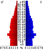
As of the 2000 United States Census,[11] there were 82,148 people, 32,301 households, and 22,093 families residing in the county. The population density was 116 people per square mile (45/km²). There were 35,133 housing units at an average density of 49 per square mile (19/km²). The racial makeup of the county was 89.27% White, 7.78% Black or African American, 0.33% Native American, 0.60% Asian, 0.02% Pacific Islander, 0.93% from other races, and 1.06% from two or more races. 2.12% of the population were Hispanic or Latino of any race.
There were 32,301 households out of which 32.30% had children under the age of 18 living with them, 53.30% were married couples living together, 11.40% had a female householder with no husband present, and 31.60% were non-families. 25.20% of all households were made up of individuals and 9.10% had someone living alone who was 65 years of age or older. The average household size was 2.46 and the average family size was 2.96.
In the county, the population was spread out with 24.10% under the age of 18, 14.00% from 18 to 24, 28.70% from 25 to 44, 21.40% from 45 to 64, and 11.80% who were 65 years of age or older. The median age was 33 years. For every 100 females, there were 93.80 males. For every 100 females age 18 and over, there were 90.50 males.
The median income for a household in the county was $32,425, and the median income for a family was $40,688. Males had a median income of $30,366 versus $21,109 for females. The per capita income for the county was $17,091. About 11.60% of families and 15.40% of the population were below the poverty line, including 19.40% of those under age 18 and 13.40% of those age 65 or over.
Government
Craighead County has voted Republican in the majority of presidential elections since 1960; prior to that it was solidly Democratic.
| Year | GOP | Dem | Others |
|---|---|---|---|
| 2016 | 64.35% 22,892 | 29.62% 10,538 | 6.03% 2,143 |
| 2012 | 64.20% 20,350 | 33.21% 10,527 | 2.60% 823 |
| 2008 | 60.97% 18,881 | 36.47% 11,294 | 2.56% 793 |
| 2004 | 53.08% 15,818 | 45.85% 13,665 | 1.07% 318 |
| 2000 | 48.33% 12,158 | 49.20% 12,376 | 2.48% 623 |
| 1996 | 37.47% 9,210 | 54.04% 13,284 | 8.49% 2,088 |
| 1992 | 35.57% 9,104 | 54.43% 13,931 | 10.00% 2,561 |
| 1988 | 54.99% 11,887 | 42.02% 9,083 | 2.98% 645 |
| 1984 | 62.87% 14,047 | 35.96% 8,035 | 1.17% 261 |
| 1980 | 51.31% 11,010 | 43.02% 9,231 | 5.66% 1,215 |
| 1976 | 30.98% 6,213 | 69.02% 13,840 | |
| 1972 | 65.94% 11,312 | 34.06% 5,843 | 0.00% 0 |
| 1968 | 32.50% 5,047 | 24.07% 3,738 | 43.42% 6,742 |
| 1964 | 38.13% 5,163 | 61.55% 8,334 | 0.32% 44 |
| 1960 | 48.97% 5,258 | 45.61% 4,898 | 5.42% 582 |
| 1956 | 40.11% 4,035 | 58.41% 5,876 | 1.48% 149 |
| 1952 | 41.16% 4,199 | 58.57% 5,975 | 0.27% 28 |
| 1948 | 14.85% 759 | 63.37% 3,238 | 21.78% 1,113 |
| 1944 | 29.05% 1,474 | 70.60% 3,582 | 0.35% 18 |
| 1940 | 21.94% 935 | 77.43% 3,300 | 0.63% 27 |
| 1936 | 17.46% 710 | 82.02% 3,335 | 0.52% 21 |
| 1932 | 11.96% 606 | 87.09% 4,412 | 0.95% 48 |
| 1928 | 47.55% 1,958 | 51.77% 2,132 | 0.68% 28 |
| 1924 | 29.06% 812 | 61.24% 1,711 | 9.70% 271 |
| 1920 | 32.64% 1,058 | 64.15% 2,079 | 3.21% 104 |
| 1916 | 21.72% 543 | 78.28% 1,957 | 0.00% 0 |
| 1912 | 13.10% 269 | 61.30% 1,259 | 25.61% 526 |
| 1908 | 27.73% 711 | 64.47% 1,653 | 7.80% 200 |
| 1904 | 32.48% 559 | 61.07% 1,051 | 6.45% 111 |
| 1900 | 26.07% 489 | 70.68% 1,326 | 3.25% 61 |
| 1896 | 14.79% 329 | 84.98% 1,890 | 0.22% 5 |
Craighead County Elected Officials 2013 – 2014
- County Judge Ed Hill – Democrat
- County Tax Collector – Marsha Phillips – Democrat
- County Clerk – Kade Holliday – Tea Party
- Assessor – Eddie Thomas – Democrat
- Treasurer – Terry McNatt – Democrat
- Circuit Clerk – Ann Hudson – Democrat
- Sheriff – Marty Boyd – Democrat
- Eastern District Court Clerk – Lesia Couch – Democrat
- Eastern District Deputy – Garland Tipton – Democrat
Craighead County Elected Officials 2015 – 2016
- County Judge Ed Hill – Democrat
- County Tax Collector – Marsha Phillips – Democrat
- County Clerk – Kade Holliday – Republican
- Assessor – Hannah Towel – Republican
- Treasurer – Terry McNatt – Democrat
- Circuit Clerk – Candace Edwards – Republican
- Sheriff – Marty Boyd – Democrat
- Eastern District Court Clerk – Lesia Couch – Democrat
- Eastern District Deputy – Garland Tipton – Democrat
Craighead County Elected Officials 2017 – 2018
- County Judge Ed Hill – Democrat
- County Tax Collector – Weslley Eddington – Republican
- County Clerk – Kade Holliday – Republican
- Assessor – Hannah Towel – Republican
- Treasurer – Terry McNatt – Republican
- Circuit Clerk – Candace Edwards – Republican
- Sheriff – Marty Boyd – Democrat
- Eastern District Circuit Clerk – Sue Gurley – Republican
- Eastern District Deputy – Garland Tipton – Republican
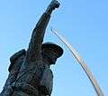 The Doughboy statue is located at the Craighead County Courthouse in Jonesboro, AR
Education
Public schools
Craighead County consists of eight public school districts with numerous secondary and elementary schools including:
- Jonesboro School District, including Jonesboro High School (Jonesboro) | 11 schools
- Nettleton School District, including Nettleton High School (Jonesboro) | 8 schools
- Buffalo Island Central School District, including Buffalo Island Central High School (Monette) | 4 schools
- Riverside School District, including Riverside High School (Lake City) | 4 schools
- Brookland School District, including Brookland High School (Brookland) | 3 schools
- Westside Consolidated School District, including Westside High School (Jonesboro, Arkansas)|Westside High School]] (Jonesboro) | 3 schools
- Bay School District, including Bay High School (Bay) | 2 schools
- Valley View School District, including Valley View High School (Jonesboro) | 2 schools
Private schools
- Ridgefield Christian School (Jonesboro) PK-12
- Blessed Sacrament School (Jonesboro) KG-6
- Concordia Christian Academy (Jonesboro) PK-6
- First Presbyterian Preschool & Kindergarten (Jonesboro) PK-KG
- Montessori School of Jonesboro (Jonesboro) PK-KG
Postsecondary education
Communities
Townships
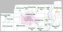
Townships in Arkansas are the divisions of a county. Each township includes unincorporated areas; some may have incorporated cities or towns within part of their boundaries. Arkansas townships have limited purposes in modern times. However, the United States Census does list Arkansas population based on townships (sometimes referred to as "county subdivisions" or "minor civil divisions"). Townships are also of value for historical purposes in terms of genealogical research. Each town or city is within one or more townships in an Arkansas county based on census maps and publications. The townships of Craighead County are listed below; listed in parentheses are the cities, towns, and/or census-designated places that are fully or partially inside the township. [13][14]
- Big Creek (Bono)
- Black Oak (Black Oak) (Caraway)
- Brookland (Brookland)
- Buffalo (Monette)
- Gilkerson (part of Jonesboro)
- Greenfield (small part of Jonesboro)
- Herndon
- Jonesboro (largest portion of Jonesboro)
- Lake City (Lake City)
- Lester
- Little Texas (small part of Cash)
- Maumelle (Bay, part of Jonesboro)
- Nettleton (part of Jonesboro)
- Powell
- Prairie
- Promised Land (Egypt)
- Taylor
- Texas (most of Cash)
See also
- List of lakes in Craighead County, Arkansas
- National Register of Historic Places listings in Craighead County, Arkansas
- Craighead County Website.
- St. Francis River Bridge (Lake City, Arkansas)
References
| Wikimedia Commons has media related to Craighead County, Arkansas. |
- "State & County QuickFacts". United States Census Bureau. Archived from the original on December 28, 2015. Retrieved May 20, 2014.
- "Find a County". National Association of Counties. Archived from the original on May 31, 2011. Retrieved 2011-06-07.
- Neville, A. W. (March 2, 1945). "Backward Glances". The Paris News. Paris, Texas. p. 4 – via Newspapers.com.
On the survey from Bird's Point, Mo., to Jonesboro, Ark., I had a Negro cook. As Negroes were not allowed to live in Clay, Greene and Craighead Counties, Ark., my cook was a curiosity to the children. The women used to bring the children to camp to see him.
- "2010 Census Gazetteer Files". United States Census Bureau. August 22, 2012. Retrieved August 25, 2015.
- "Population and Housing Unit Estimates". Retrieved September 28, 2019.
- "U.S. Decennial Census". United States Census Bureau. Retrieved August 25, 2015.
- "Historical Census Browser". University of Virginia Library. Retrieved August 25, 2015.
- Forstall, Richard L., ed. (March 27, 1995). "Population of Counties by Decennial Census: 1900 to 1990". United States Census Bureau. Retrieved August 25, 2015.
- "Census 2000 PHC-T-4. Ranking Tables for Counties: 1990 and 2000" (PDF). United States Census Bureau. April 2, 2001. Retrieved August 25, 2015.
- Based on 2000 census data
- "U.S. Census website". United States Census Bureau. Retrieved 2011-05-14.
- "Dave Leip's Atlas of U.S. Presidential Elections". Retrieved November 18, 2016.
- 2011 Boundary and Annexation Survey (BAS): Craighead County, AR (PDF) (Map). U. S. Census Bureau. Archived from the original (PDF) on 2012-10-19. Retrieved 2011-08-04.
- "Arkansas: 2010 Census Block Maps - County Subdivision". United States Census Bureau. Retrieved May 27, 2014.
Places adjacent to Craighead County, Arkansas | ||||||||||
|---|---|---|---|---|---|---|---|---|---|---|
| ||||||||||
Municipalities and communities of Craighead County, Arkansas, United States | ||
|---|---|---|
| Cities | Map of Arkansas highlighting Craighead County | |
| Towns | ||
| Unincorporated communities |
| |
| Ghost town | ||

| Authority control |
|
|---|