Yell County, Arkansas
Yell County is a county in the U.S. state of Arkansas. As of the 2010 census, the population was 22,185.[1] The county has two county seats, Dardanelle and Danville.[2] Yell County is Arkansas's 42nd county, formed on December 5, 1840 from portions of Scott and Pope counties. It was named after Archibald Yell, who was the state's first member of the United States House of Representatives and the second governor of Arkansas; he later was killed in combat at the Battle of Buena Vista during the Mexican–American War. It is an alcohol prohibition or dry county.
Yell County | |
|---|---|
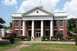
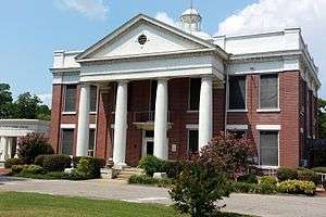 Yell County Courthouse, Dardanelle | |
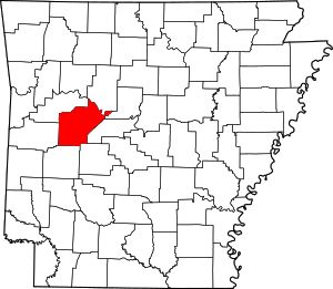 Location within the U.S. state of Arkansas | |
 Arkansas's location within the U.S. | |
| Coordinates: 34°59′54″N 93°27′09″W | |
| Country | |
| State | |
| Founded | December 5, 1840 |
| Named for | Archibald Yell |
| Seat | Danville (western district); Dardanelle (eastern district) |
| Largest city | Dardanelle |
| Government | |
| • County judge | Mark Thone |
| Area | |
| • Total | 949 sq mi (2,460 km2) |
| • Land | 930 sq mi (2,400 km2) |
| • Water | 19 sq mi (50 km2) 2.0%% |
| Population (2010) | |
| • Total | 22,185 |
| • Estimate (2019) | 21,341 |
| • Density | 23/sq mi (9.0/km2) |
| Time zone | UTC−6 (Central) |
| • Summer (DST) | UTC−5 (CDT) |
| Congressional district | 4th |
| Website | yellcounty |
Yell County is part of the Russellville, AR Micropolitan Statistical Area.
History
Native Americans first inhabited present-day Yell County and the Arkansas River Valley for centuries prior to European colonization, using the open, fertile floodplain of the Arkansas River for hunting grounds and farming settlements. During the Thomas Jefferson and Indian Removal era, many Cherokee were voluntarily relocating from Georgia along the Arkansas River, including in Yell County, between 1775 and 1786. A large Cherokee reservation across the Arkansas River from Yell County was established in 1815 to encourage further voluntary relocation from Georgia.
The area presently encompassed as Yell County was first settled by European settlers when James Carden built a house among Cherokee farms in the Dardanelle Bottoms at the confluence of the Arkansas and Petit Jean Rivers in 1819.[3] Lands south of the Arkansas River had been deeded to the Choctaw in 1820s, but white settlement and Cherokee relocation continued apace into the 1820s, spurring conflicts over the prime river-bottom lands. In 1822, the Council Oaks Treaty meeting was held under two large oak trees, reestablishing Cherokee title of 3.2 million acres (1.3 million hectares) north of the Arkansas River previously granted in 1817 in exchange for removing north of the river. The Cherokee that remained south of the river became known as the "Black Dutch", and largely assimilated.[4]
In 1830, the United States Congress enacted the Indian Removal Act, leading to further, now involuntary, Cherokee settlement in the Arkansas River Valley. Cherokee, Muskogee (Creek), and Seminole were forcibly removed along the Trail of Tears through Yell County to present-day Oklahoma.
Geography
According to the U.S. Census Bureau, the county has a total area of 949 square miles (2,460 km2), of which 930 square miles (2,400 km2) is land and 19 square miles (49 km2) (2.0%) is water.[5]
Adjacent counties
- Pope County (north)
- Conway County (northeast)
- Perry County (east)
- Garland County (southeast)
- Montgomery County (south)
- Scott County (west)
- Logan County (northwest)
National protected areas
- Holla Bend National Wildlife Refuge (part)
- Ouachita National Forest (part)
- Ozark National Forest (part)
Demographics
| Historical population | |||
|---|---|---|---|
| Census | Pop. | %± | |
| 1850 | 3,341 | — | |
| 1860 | 6,333 | 89.6% | |
| 1870 | 8,048 | 27.1% | |
| 1880 | 13,852 | 72.1% | |
| 1890 | 18,015 | 30.1% | |
| 1900 | 22,750 | 26.3% | |
| 1910 | 26,323 | 15.7% | |
| 1920 | 25,655 | −2.5% | |
| 1930 | 21,313 | −16.9% | |
| 1940 | 20,970 | −1.6% | |
| 1950 | 14,057 | −33.0% | |
| 1960 | 11,940 | −15.1% | |
| 1970 | 14,208 | 19.0% | |
| 1980 | 17,026 | 19.8% | |
| 1990 | 17,759 | 4.3% | |
| 2000 | 21,139 | 19.0% | |
| 2010 | 22,185 | 4.9% | |
| Est. 2019 | 21,341 | [6] | −3.8% |
| U.S. Decennial Census[7] 1790–1960[8] 1900–1990[9] 1990–2000[10] 2010–2016[1] | |||
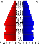
As of the 2000 census,[12] there were 21,139 people, 7,922 households, and 5,814 families residing in the county. The population density was 23 people per square mile (9/km²). There were 9,157 housing units at an average density of 10 per square mile (4/km²). The racial makeup of the county was 86.63% White, 1.47% Black or African American, 0.58% Native American, 0.69% Asian, 0.03% Pacific Islander, 8.99% from other races, and 1.62% from two or more races. 12.73% of the population were Hispanic or Latino of any race. 12.00% reported speaking Spanish at home.[13]
There were 7,922 households out of which 33.60% had children under the age of 18 living with them, 58.50% were married couples living together, 10.10% had a female householder with no husband present, and 26.60% were non-families. 23.20% of all households were made up of individuals and 11.80% had someone living alone who was 65 years of age or older. The average household size was 2.61 and the average family size was 3.04.
In the county, the population was spread out with 25.80% under the age of 18, 8.90% from 18 to 24, 28.30% from 25 to 44, 22.00% from 45 to 64, and 15.00% who were 65 years of age or older. The median age was 36 years. For every 100 females, there were 99.50 males. For every 100 females age 18 and over, there were 96.30 males.
The median income for a household in the county was $28,916, and the median income for a family was $33,409. Males had a median income of $23,172 versus $18,148 for females. The per capita income for the county was $15,383. About 11.70% of families and 15.40% of the population were below the poverty line, including 20.20% of those under age 18 and 12.80% of those age 65 or over.
Human resources
Public safety
The Yell County Sheriff's Office is the primary law enforcement agency in the county. The agency is led by the Yell County Sheriff, an official elected by countywide vote every four years. Police departments in Dardanelle, Danville, and Ola provide law enforcement in their respective jurisdictions, with Bellville, Havana, and Plainview contracting with the Sheriff's Office for law enforcement services.
The current sheriff of Yell County is Bill Gilkey, who has served since 1998. In 2017, he became the longest currently-serving sheriff in Arkansas, after 19 years in the office. He is also the longest-serving sheriff in the county's history.[14] He has announced that he will retire after his term ends in 2022. Gilkey has sat on state boards such as the Arkansas Crime Lab Board and is still currently on the Arkansas Act 309 Board.
Gilkey is credited with the creation of the Yell County Law Enforcement Center in 2016, which replaces two of the county's older jails that did not meet state standards, and houses the sheriff's office. The new building also houses CID offices, revenue office, and an updated E911 dispatch center.[15]
The chief officer of the law in Yell County, as in all Arkansas counties, is the sheriff.
| Name | Year Elected | Year Left | Total Years | Notable Accomplishments |
|---|---|---|---|---|
| Theodore P Sadler | 1840 | 1846 | 6 |
|
| S. Kirkpatrick | 1846 | 1852 | 6 | |
| Joseph Garrett | 1852 | 1854 | 2 | |
| J. C. Herin | 1854 | 1856 | 2 | |
| Joseph Gault | 1856 | 1862 | 6 | |
| Lorenzo Free | 1862 | 1863 | 1 | |
| O. Wood | 1863 | 1864 | 1 | |
| William Henry Ferguson | 1864 | 1871 | 7 | |
| Jesse George | 1871 | 1872 | 1 | |
| J. A. Wilson | 1872 | 1874 | 2 | |
| Reuben E. Cole | 1874 | 1880 | 6 | |
| Levi L. Briggs | 1880 | 1882 | 2 | |
| Joseph L. Davis | 1882 | 1886 | 4 | |
| H. B. McCarrell | 1886 | 1890 | 4 | |
| Joseph Haston Howard | 1890 | 1892 | 2 | |
| Sam Gordon Albright | 1892 | 1896 | 4 | |
| B. H. Burnett | 1896 | 1900 | 6 | |
| James M. Cole | 1900 | 1904 | 4 | |
| William Franklin Briggs | 1904 | 1906 | 2 | |
| William L. Tatum | 1906 | 1910 | 4 | |
| Theodore Riley Gault | 1910 | 1914 | 4 | |
| Will T. Caviness | 1914 | 1919 | 5 | |
| J. N. George | 1919 | 1923 | 4 | |
| Joe D. Gault | 1923 | 1926 | 3 | |
| Baxter Gatlin | 1927 | 1930 | 3 | |
| Buford Compton | 1931 | 1946 | 15 | |
| Earl E Lad | 1947 | 1956 | 9 | |
| Herman D. McCormick | 1957 | 1968 | 11 | |
| Carlos Mitchell | 1969 | 1976 | 7 |
|
| Hartsell Lewis | 1977 | 1978 | 1 | |
| Denver Dennis | 1979 | 1988 | 9 | |
| Mike May | 1989 | 1992 | 3 | |
| Loyd W. Maughn | 1993 | 1998 | 5 |
|
| Bill Gilkey | 1999 | 2022 | 23 |
|
Government
The county government is a constitutional body granted specific powers by the Constitution of Arkansas and the Arkansas Code. The quorum court is the legislative branch of the county government and controls all spending and revenue collection. Representatives are called justices of the peace and are elected from county districts every even-numbered year. The number of districts in a county vary from nine to fifteen, and district boundaries are drawn by the county election commission. The Yell County Quorum Court has eleven members.[18] Presiding over quorum court meetings is the county judge, who serves as the chief operating officer of the county. The county judge is elected at-large and does not vote in quorum court business, although capable of vetoing quorum court decisions.[19][20] Though Yell County has two county seats, the constitutional officers are not duplicated, with duties split between the two courthouses.
Politics
Over the past few election cycles Yell county has trended heavily towards the GOP. The last Democratic presidential candidate (as of 2016) to carry this county was Bill Clinton in 1996.
| Year | GOP | Dem | Others |
|---|---|---|---|
| 2016 | 71.56% 4,608 | 22.98% 1,480 | 5.45% 351 |
| 2012 | 67.66% 4,042 | 28.82% 1,722 | 3.52% 210 |
| 2008 | 63.09% 3,808 | 33.18% 2,003 | 3.73% 225 |
| 2004 | 55.23% 3,678 | 43.75% 2,913 | 1.02% 68 |
| 2000 | 49.75% 3,223 | 47.26% 3,062 | 2.99% 194 |
| 1996 | 31.77% 2,111 | 56.43% 3,749 | 11.80% 784 |
| 1992 | 32.79% 2,506 | 54.49% 4,165 | 12.72% 972 |
| 1988 | 55.84% 3,535 | 43.64% 2,763 | 0.52% 33 |
| 1984 | 59.56% 4,051 | 39.39% 2,679 | 1.06% 72 |
| 1980 | 44.65% 3,187 | 51.87% 3,702 | 3.48% 248 |
| 1976 | 25.04% 1,932 | 74.96% 5,785 | |
| 1972 | 66.48% 3,310 | 33.52% 1,669 | 0.00% 0 |
| 1968 | 34.44% 1,819 | 28.65% 1,513 | 36.91% 1,949 |
| 1964 | 30.86% 1,527 | 68.86% 3,407 | 0.28% 14 |
| 1960 | 37.96% 1,303 | 58.49% 2,008 | 3.55% 122 |
| 1956 | 40.70% 1,381 | 59.18% 2,008 | 0.12% 4 |
| 1952 | 39.54% 1,243 | 59.92% 1,884 | 0.54% 17 |
| 1948 | 16.85% 408 | 77.08% 1,866 | 6.08% 147 |
| 1944 | 22.94% 489 | 77.02% 1,642 | 0.05% 1 |
| 1940 | 9.08% 224 | 90.64% 2,236 | 0.28% 7 |
| 1936 | 11.78% 318 | 88.22% 2,382 | 0.00% 0 |
| 1932 | 11.88% 272 | 87.77% 2,010 | 0.35% 8 |
| 1928 | 27.65% 802 | 71.91% 2,086 | 0.45% 13 |
| 1924 | 19.15% 334 | 75.34% 1,314 | 5.50% 96 |
| 1920 | 34.21% 1,042 | 63.20% 1,925 | 2.59% 79 |
| 1916 | 27.12% 781 | 72.88% 2,099 | 0.00% 0 |
| 1912 | 17.18% 436 | 55.20% 1,401 | 27.62% 701 |
| 1908 | 34.70% 1,040 | 58.16% 1,743 | 7.14% 214 |
| 1904 | 44.32% 913 | 52.38% 1,079 | 3.30% 68 |
| 1900 | 33.73% 798 | 65.68% 1,554 | 0.59% 14 |
| 1896 | 26.32% 812 | 73.29% 2,261 | 0.39% 12 |
Education
Public education
Early childhood, elementary and secondary education within Yell County is provided by four public school districts:
- Danville School District
- Dardanelle School District
- Two Rivers School District—formed in 2004 by the consolidation of the former Fourche Valley School District, Ola School District, Perry–Casa School District, and Plainview–Rover School District.
- Western Yell County School District—formed in 1985 by the consolidation of the former Belleville School District and Havana School District.
Dissolved school districts
- Fourche Valley School District
- Ola School District
- Perry–Casa School District
- Plainview-Rover School District
- Havana School District
- Belleville School District
- Carden Bottoms School District
Public libraries
The Arkansas River Valley Regional Library System, is headquartered in Dardanelle and serves multiple counties and consists of one central library and six branch libraries, including the Yell County Library, a branch library in Danville.
Communities
Cities
- Belleville
- Danville (county seat)
- Dardanelle (county seat)
- Havana
- Ola
- Plainview
Towns
Unincorporated communities
Townships
Townships in Arkansas are the divisions of a county. Each township includes unincorporated areas; some may have incorporated cities or towns within part of their boundaries. Arkansas townships have limited purposes in modern times. However, the United States Census does list Arkansas population based on townships (sometimes referred to as "county subdivisions" or "minor civil divisions"). Townships are also of value for historical purposes in terms of genealogical research. Each town or city is within one or more townships in an Arkansas county based on census maps and publications. The townships of Yell County are listed below; listed in parentheses are the cities, towns, and/or census-designated places that are fully or partially inside the township. [22][23]
- Birta
- Bluffton
- Briggsville
- Centerville
- Chula
- Compton
- Crawford
- Danville (Corinth, Danville)
- Dardanelle (Dardanelle)
- Dutch Creek
- Ferguson (Belleville)
- Galla Rock
- Gilkey
- Gravelly Hill
- Herring
- Ions Creek
- Lamar (Plainview)
- Magazine
- Mason
- Mountain
- Prairie
- Richland
- Riley (Havana)
- Rover
- Sulphur Springs
- Ward (Ola)
- Waveland
Infrastructure
Major highways


Notable people
- Ray R. Allen (1920–2010), public official in Alexandria, Louisiana, was born in Yell County.
- John Daly, professional golfer
- Arthur Hunnicutt, Academy Award-nominated Western Actor
- Kelly Ring, WTVT news anchor
- Johnny Sain, Major League Baseball player
- William L. Spicer, Republican state chairman, 1962–1964, was born in Yell County, but owned a chain of drive-in theaters in Fort Smith.
- Cousins Jim Walkup (left-handed pitcher), and Jim Walkup (right-handed pitcher), MLB pitchers
- James Lee Witt, former FEMA Director
- Henry C. Bruton, Rear Admiral in the United States Navy, born in Belleville, Arkansas in 1905
- Jacob Lofland, American actor
Trivia
- In the novel True Grit, the heroine Mattie Ross is from near Dardanelle in Yell County.
- First Sergeant William Ellis of the 3rd Wisconsin Cavalry, was awarded the Medal of Honor for his valor and bravery above and beyond the call of duty at Dardanelle. At 10 a.m. on January 14, 1865, approximately 1,500 Confederates attacked the Union forces entrenched on the outskirts of the town and a fierce four-hour battle was waged. In the end Confederate Colonel William H. Brooks was unable to overcome the Union defenders of the town and was forced to retreat. It was during this battle that Ellis held his position even after receiving three wounds and would not withdraw for medical attention until he received a fourth wound and was ordered to retire by his commanding officer.
- Yell County was the birthplace of Gretchen McNairy, a moe character from the animated TV series Lukas. The county is referenced several times, and is often portrayed as a land of milk and honey, despite its depressing poverty, since it is the only place where Gretchen's parents actually loved her.
See also
- List of lakes in Yell County, Arkansas
- National Register of Historic Places listings in Yell County, Arkansas
References
- "State & County QuickFacts". United States Census Bureau. Retrieved May 19, 2014.
- "Find a County". National Association of Counties. Retrieved June 7, 2011.
- "Gleason" (2017), p. 12.
- "Gleason" (2017), p. 13.
- "2010 Census Gazetteer Files". United States Census Bureau. August 22, 2012. Retrieved August 27, 2015.
- "Population and Housing Unit Estimates". Retrieved September 28, 2019.
- "U.S. Decennial Census". United States Census Bureau. Retrieved August 27, 2015.
- "Historical Census Browser". University of Virginia Library. Retrieved August 27, 2015.
- Forstall, Richard L., ed. (March 27, 1995). "Population of Counties by Decennial Census: 1900 to 1990". United States Census Bureau. Retrieved August 27, 2015.
- "Census 2000 PHC-T-4. Ranking Tables for Counties: 1990 and 2000" (PDF). United States Census Bureau. April 2, 2001. Retrieved August 27, 2015.
- Based on 2000 census data
- "U.S. Census website". United States Census Bureau. Retrieved May 14, 2011.
- http://www.mla.org/map_data_results&state_id=5&county_id=149&mode=geographic&order=r
- "Gilkey is longest-tenured sheriff in Arkansas". River Valley Leader. Retrieved February 12, 2018.
- "Photos: Yell County Law Enforcement Center nears completion", River Valley Leader, January 5, 2016.
- Yell County Court House Records
- "Wayback Machine". January 8, 2014. Archived from the original on January 8, 2014. Retrieved October 9, 2018.
- "Yell County". Little Rock: Arkansas Association of Counties. Retrieved June 7, 2020.
- Teske, Steven (March 24, 2014). "Quorum Courts". Encyclopedia of Arkansas History and Culture. Butler Center for Arkansas Studies at the Central Arkansas Library System. Retrieved January 23, 2016.
- Goss, Kay C. (August 28, 2015). "Office of County Judge". Encyclopedia of Arkansas History and Culture. Butler Center for Arkansas Studies at the Central Arkansas Library System. Retrieved January 23, 2016.
- "Dave Leip's Atlas of U.S. Presidential Elections". Retrieved November 18, 2016.
- 2011 Boundary and Annexation Survey (BAS): Yell County, AR (PDF) (Map). U. S. Census Bureau. Archived from the original (PDF) on October 19, 2012. Retrieved August 24, 2011.
- "Arkansas: 2010 Census Block Maps – County Subdivision". United States Census Bureau. Retrieved May 29, 2014.
- Gleason, Mildred Diane (2017). Dardanelle and the Bottoms: Environment, Agriculture, and Economy in an Arkansas River Community, 1819-1970. Fayetteville: The University of Arkansas Press. ISBN 9781682260388. LCCN 2017932453.
External links
- Yell County official website
- Yell County, Arkansas entry on the Encyclopedia of Arkansas History & Culture
Places adjacent to Yell County, Arkansas | |
|---|---|
Municipalities and communities of Yell County, Arkansas, United States | ||
|---|---|---|
| Cities | Map of Arkansas highlighting Yell County | |
| Town | ||
| Unincorporated communities | ||
| Footnotes | ‡This populated place also has portions in an adjacent county or counties | |

| Authority control |
|
|---|