Desha County, Arkansas
Desha County /dəˈʃeɪ/ is a county located in the southeast part of the U.S. state of Arkansas, with its eastern border the Mississippi River. As of the 2010 census, the population was 13,008. It ranks fifty-sixth of Arkansas's seventy-five counties in terms of population.[1] The county seat is Arkansas City.[2] Located in the Arkansas Delta, Desha County's rivers and fertile soils became prosperous for planters under the cotton-based economy of plantation agriculture in the antebellum years and late nineteenth century. Still largely rural, it has suffered population losses and economic decline since the mid-20th century.
Desha County | |
|---|---|
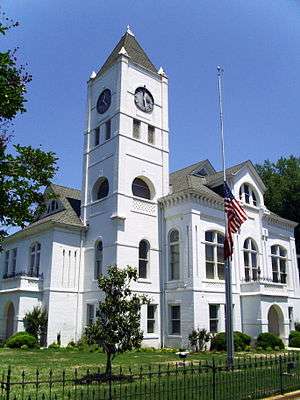 Desha County courthouse in Arkansas City | |
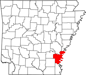 Location within the U.S. state of Arkansas | |
 Arkansas's location within the U.S. | |
| Coordinates: 33°45′28″N 91°17′14″W | |
| Country | |
| State | |
| Founded | December 12, 1838 |
| Named for | Benjamin Desha |
| Seat | Arkansas City |
| Largest city | Dumas |
| Area | |
| • Total | 820 sq mi (2,100 km2) |
| • Land | 768 sq mi (1,990 km2) |
| • Water | 51 sq mi (130 km2) 6.3%% |
| Population (2010) | |
| • Total | 13,008 |
| • Estimate (2019) | 11,361 |
| • Density | 16/sq mi (6.1/km2) |
| Time zone | UTC−6 (Central) |
| • Summer (DST) | UTC−5 (CDT) |
| Congressional district | 1st |
| Website | deshacounty |
But following widespread farm mechanization, Desha County underwent a demographic and economic transformation. Farm workers left the area because of the lack of work, and there was a decline in population. Farm holdings have been consolidated into industrial style farms and the economy cannot support much activity. In the 21st century, the county is seeking to reverse population and economic losses through better education for its workforce, and developing tourism based on its cultural, historical and outdoor recreation amenities.[3]
History
Desha County was created by the Arkansas Legislature on December 12, 1838, consisting of the lands of Arkansas County separated from the county seat by the Arkansas River and the White River, and land from Chicot County. The county was named for Captain Benjamin Desha, who fought in the War of 1812.[3][4]
Located in the Arkansas Delta, Desha County's rivers and fertile soils prosperous for planters under the cotton-based slave society of plantation agriculture in the antebellum years. After the Civil War, cotton continued as the primary commodity crop into the early 20th century, and planters did well. Labor was provided by sharecroppers and tenant farmers.
But following widespread farm mechanization, laborers were thrown off the land, and Desha County had a demographic and economic transformation. Thousands of African-American farm workers left the area and went north or west in the Great Migration, and there was a decline in population. Farm holdings have been consolidated into industrial-scale farms, with few governmental benefits for small farmers, and the economy cannot support much activity. In the 21st century, the county is seeking to reverse population and economic losses through better education for its workforce, and developing tourism based on its cultural, historical and outdoor recreation amenities.[3]
During World War II, the federal government established the Rohwer War Relocation Center, an internment camp for Japanese nationals and Japanese Americans it forced out of the coastal area of California, the U.S. Pacific Northwest, and Alaska. The camp operated from late 1942 into 1945 and the end of the war, holding up to nearly 8500 ethnic Japanese, many American-born citizens. The Rohwer War Relocation Center Cemetery has been designated as a National Historic Landmark.
Geography
According to the U.S. Census Bureau, the county has a total area of 820 square miles (2,100 km2), of which 768 square miles (1,990 km2) is land and 51 square miles (130 km2) (6.3%) is water.[5] Desha County is within the Arkansas Delta and is considered a member of the Southeast Arkansas region.
Major highways
.svg.png)


Adjacent counties
- Arkansas County (north)
- Phillips County (northeast)
- Bolivar County, Mississippi (east)
- Chicot County (south)
- Drew County (southwest)
- Lincoln County (northwest)
National protected area
Demographics
| Historical population | |||
|---|---|---|---|
| Census | Pop. | %± | |
| 1840 | 1,598 | — | |
| 1850 | 2,911 | 82.2% | |
| 1860 | 6,459 | 121.9% | |
| 1870 | 6,125 | −5.2% | |
| 1880 | 8,973 | 46.5% | |
| 1890 | 10,324 | 15.1% | |
| 1900 | 11,511 | 11.5% | |
| 1910 | 15,274 | 32.7% | |
| 1920 | 20,297 | 32.9% | |
| 1930 | 21,814 | 7.5% | |
| 1940 | 27,160 | 24.5% | |
| 1950 | 25,155 | −7.4% | |
| 1960 | 20,770 | −17.4% | |
| 1970 | 18,761 | −9.7% | |
| 1980 | 19,760 | 5.3% | |
| 1990 | 16,798 | −15.0% | |
| 2000 | 15,341 | −8.7% | |
| 2010 | 13,008 | −15.2% | |
| Est. 2019 | 11,361 | [6] | −12.7% |
| U.S. Decennial Census[7] 1790–1960[8] 1900–1990[9] 1990–2000[10] 2010–2016[1] | |||
As of the 2000 census,[12] there were 15,341 people, 5,922 households, and 4,192 families residing in the county. The population density was 20 people per square mile (8/km²). There were 6,663 housing units at an average density of 9 per square mile (3/km²). The racial makeup of the county was 50.50% White, 46.33% Black or African American, 0.35% Native American, 0.30% Asian, 0.03% Pacific Islander, 1.73% from other races, and 0.76% from two or more races. 3.16% of the population were Hispanic or Latino of any race.
There were 5,922 households out of which 34.60% had children under the age of 18 living with them, 46.50% were married couples living together, 19.90% had a female householder with no husband present, and 29.20% were non-families. 26.90% of all households were made up of individuals and 12.70% had someone living alone who was 65 years of age or older. The average household size was 2.57 and the average family size was 3.10.
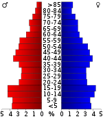
In the county, the population was spread out with 28.90% under the age of 18, 9.00% from 18 to 24, 25.20% from 25 to 44, 22.70% from 45 to 64, and 14.20% who were 65 years of age or older. The median age was 36 years. For every 100 females, there were 87.60 males. For every 100 females age 18 and over, there were 82.90 males.
The median income for a household in the county was $24,121, and the median income for a family was $30,028. Males had a median income of $29,623 versus $18,913 for females. The per capita income for the county was $13,446. About 23.60% of families and 28.90% of the population were below the poverty line, including 39.60% of those under age 18 and 24.00% of those age 65 or over.
Government
Desha County is traditionally Democratic, and has remained so in recent years even as Arkansas as a whole has shifted to the right.
| Year | GOP | Dem | Others |
|---|---|---|---|
| 2016 | 45.08% 1,919 | 52.34% 2,228 | 2.58% 110 |
| 2012 | 42.90% 1,896 | 55.27% 2,443 | 1.83% 81 |
| 2008 | 42.73% 1,999 | 54.92% 2,569 | 2.35% 110 |
| 2004 | 37.21% 1,729 | 61.35% 2,851 | 1.44% 67 |
| 2000 | 35.66% 1,603 | 61.76% 2,776 | 2.59% 116 |
| 1996 | 21.48% 978 | 70.94% 3,230 | 7.57% 345 |
| 1992 | 22.75% 1,279 | 67.87% 3,815 | 9.37% 527 |
| 1988 | 42.94% 2,334 | 52.60% 2,859 | 4.45% 242 |
| 1984 | 45.87% 2,696 | 49.64% 2,918 | 4.49% 264 |
| 1980 | 34.07% 2,057 | 62.08% 3,748 | 3.85% 232 |
| 1976 | 24.50% 1,372 | 75.50% 4,228 | |
| 1972 | 66.92% 3,385 | 32.92% 1,665 | 0.16% 8 |
| 1968 | 17.00% 972 | 39.71% 2,270 | 43.28% 2,474 |
| 1964 | 36.86% 1,930 | 62.91% 3,294 | 0.23% 12 |
| 1960 | 27.01% 1,063 | 63.57% 2,502 | 9.43% 371 |
| 1956 | 28.73% 1,204 | 70.03% 2,935 | 1.24% 52 |
| 1952 | 24.74% 1,037 | 75.14% 3,150 | 0.12% 5 |
| 1948 | 7.68% 233 | 69.96% 2,122 | 22.35% 678 |
| 1944 | 13.66% 186 | 86.27% 1,175 | 0.07% 1 |
| 1940 | 9.57% 146 | 89.78% 1,370 | 0.66% 10 |
| 1936 | 3.75% 55 | 96.12% 1,411 | 0.14% 2 |
| 1932 | 4.94% 81 | 94.51% 1,549 | 0.55% 9 |
| 1928 | 23.39% 331 | 76.47% 1,082 | 0.14% 2 |
| 1924 | 21.55% 209 | 55.67% 540 | 22.78% 221 |
| 1920 | 27.40% 360 | 70.85% 931 | 1.75% 23 |
| 1916 | 27.77% 369 | 72.23% 960 | 0.00% 0 |
| 1912 | 9.63% 52 | 58.15% 314 | 32.22% 174 |
| 1908 | 33.21% 263 | 65.40% 518 | 1.39% 11 |
| 1904 | 28.57% 82 | 71.08% 204 | 0.35% 1 |
| 1900 | 33.27% 168 | 64.95% 328 | 1.78% 9 |
| 1896 | 40.50% 290 | 55.31% 396 | 4.19% 30 |
Communities[14]
Cities
- Arkansas City (county seat)
- Dumas
- McGehee
- Mitchellville
- Tillar (partly in Drew County)
- Watson
Towns
Historic community
Townships
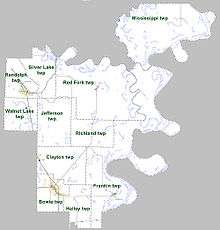
Townships in Arkansas are the divisions of a county. Each township includes unincorporated areas; some may have incorporated cities or towns within part of their boundaries. Arkansas townships have limited purposes in modern times. However, the United States Census does list Arkansas population based on townships (sometimes referred to as "county subdivisions" or "minor civil divisions"). Townships are also of value for historical purposes in terms of genealogical research. Each town or city is within one or more townships in an Arkansas county based on census maps and publications. The townships of Desha County are listed below; listed in parentheses are the cities, towns, and/or census-designated places that are fully or partially inside the township. [15][16]
- Bowie (most of McGehee)
- Clayton (Reed, Tillar, small part of McGehee)
- Franklin (Arkansas City)
- Halley (small part of McGehee)
- Jefferson
- Mississippi
- Randolph (Mitchellville, most of Dumas)
- Red Fork (Watson)
- Richland
- Silver Lake
- Walnut Lake
Notable people
- Garland Bayliss
- John "Kayo" Dottley
- Jim Hines
- John H. Johnson
- Major Jones
- Mark D. McElroy
- Doug Terry
- Barry Williamson
See also
- List of lakes in Desha County, Arkansas
- National Register of Historic Places listings in Desha County, Arkansas
References
- "State & County QuickFacts". United States Census Bureau. Archived from the original on July 28, 2011. Retrieved May 20, 2014.
- "Find a County". National Association of Counties. Archived from the original on 2011-05-31. Retrieved 2011-06-07.
- "Desha County". Encyclopedia of Arkansas History & Culture. The Central Arkansas Library System. 2009. Retrieved June 29, 2014.
- Gannett, Henry (1905). The Origin of Certain Place Names in the United States. Govt. Print. Off. pp. 105.
- "2010 Census Gazetteer Files". United States Census Bureau. August 22, 2012. Retrieved August 26, 2015.
- "Population and Housing Unit Estimates". Retrieved September 28, 2019.
- "U.S. Decennial Census". United States Census Bureau. Retrieved August 26, 2015.
- "Historical Census Browser". University of Virginia Library. Retrieved August 26, 2015.
- Forstall, Richard L., ed. (March 27, 1995). "Population of Counties by Decennial Census: 1900 to 1990". United States Census Bureau. Retrieved August 26, 2015.
- "Census 2000 PHC-T-4. Ranking Tables for Counties: 1990 and 2000" (PDF). United States Census Bureau. April 2, 2001. Retrieved August 26, 2015.
- Based on 2000 census data
- "U.S. Census website". United States Census Bureau. Retrieved 2011-05-14.
- "Dave Leip's Atlas of U.S. Presidential Elections". Retrieved November 18, 2016.
- "AR Census Data - Arkansas Economic Development Institute". Arkansas Economic Development Institute. Retrieved 2018-08-28.
- 2011 Boundary and Annexation Survey (BAS): Desha County, AR (PDF) (Map). U. S. Census Bureau. Archived from the original (PDF) on 2012-10-19. Retrieved 2011-08-21.
- "Arkansas: 2010 Census Block Maps - County Subdivision". United States Census Bureau. Retrieved May 28, 2014.
| Wikimedia Commons has media related to Desha County, Arkansas. |
Places adjacent to Desha County, Arkansas | ||||||||||
|---|---|---|---|---|---|---|---|---|---|---|
| ||||||||||
Municipalities and communities of Desha County, Arkansas, United States | ||
|---|---|---|
| Cities | Map of Arkansas highlighting Desha County | |
| Towns | ||
| Unincorporated communities | ||
| Ghost town | ||
| Footnotes | ‡This populated place also has portions in an adjacent county or counties | |

| Authority control |
|
|---|