Grant County, Arkansas
Grant County is a county in the U.S. state of Arkansas. Its population was 17,853 at the 2010 United States Census.[1] The county seat is Sheridan.[2]
Grant County | |
|---|---|
| County of Grant | |
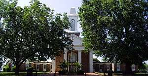 Grant County Courthouse in Sheridan | |
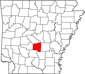 Location within the U.S. state of Arkansas | |
 Arkansas's location within the U.S. | |
| Coordinates: 34°17′40″N 92°25′54″W | |
| Country | |
| State | |
| Founded | February 4, 1869 |
| Named for | Ulysses S. Grant |
| Seat | Sheridan |
| Largest city | Sheridan |
| Area | |
| • Total | 633 sq mi (1,640 km2) |
| • Land | 632 sq mi (1,640 km2) |
| • Water | 1.1 sq mi (3 km2) 0.2%% |
| Population (2010) | |
| • Total | 17,853 |
| • Estimate (2019) | 18,265 |
| • Density | 28/sq mi (11/km2) |
| Time zone | UTC−6 (Central) |
| • Summer (DST) | UTC−5 (CDT) |
| Congressional district | 4th |
| Website | www |
Grant County is included in the Little Rock–North Little Rock–Conway, AR Metropolitan Statistical Area.
History
Formed on February 4, 1869, Grant County is named for former U.S. President Ulysses S. Grant.[3][4] It is an alcohol prohibition or dry county.
Robert W. Glover, a Missionary Baptist pastor who served in both houses of the Arkansas Legislature (1905-1912) from Sheridan, introduced in 1909 the resolution calling for the establishment of four state agricultural colleges.[5] His brother, David Delano Glover, a Methodist, was a state representative in the 1907 session and a member of the United States House of Representatives from 1929 to 1935, having been unseated in 1934 by Grant County native John Little McClellan who at the time was practicing law in Camden. McClellan later went on to become Arkansas's longest serving U.S. senator.
Geography
According to the U.S. Census Bureau, the county has a total area of 633 square miles (1,640 km2), of which 632 square miles (1,640 km2) is land and 1.1 square miles (2.8 km2) (0.2%) is water.[6] Grant County is considered part of the Arkansas Timberlands geographical area.
Major highways


Adjacent counties
- Saline County (north)
- Pulaski County (northeast)
- Jefferson County (east)
- Cleveland County (southeast)
- Dallas County (south)
- Hot Spring County (west)
Demographics
| Historical population | |||
|---|---|---|---|
| Census | Pop. | %± | |
| 1870 | 3,943 | — | |
| 1880 | 6,185 | 56.9% | |
| 1890 | 7,786 | 25.9% | |
| 1900 | 7,671 | −1.5% | |
| 1910 | 9,425 | 22.9% | |
| 1920 | 10,710 | 13.6% | |
| 1930 | 9,834 | −8.2% | |
| 1940 | 10,477 | 6.5% | |
| 1950 | 9,024 | −13.9% | |
| 1960 | 8,294 | −8.1% | |
| 1970 | 9,711 | 17.1% | |
| 1980 | 13,008 | 34.0% | |
| 1990 | 13,948 | 7.2% | |
| 2000 | 16,464 | 18.0% | |
| 2010 | 17,853 | 8.4% | |
| Est. 2019 | 18,265 | [7] | 2.3% |
| U.S. Decennial Census[8] 1790–1960[9] 1900–1990[10] 1990–2000[11] 2010–2016[1] | |||
As of the 2000 census,[13] there were 16,464 people, 4,241 households, and 4,780 families residing in the county. The population density was 26 people per square mile (10/km2). There were 6,960 housing units at an average density of 11 per square mile (4/km2). The racial makeup of the county was 95.55% White, 2.47% Black or African American, 0.45% Native American, 0.13% Asian, 0.03% Pacific Islander, 0.64% from other races, and 0.73% from two or more races. 1.15% of the population were Hispanic or Latino of any race.
There were 6,241 households, out of which 35.60% had children under the age of 18 living with them, 64.70% were married couples living together, 8.50% had a female householder with no husband present, and 23.40% were non-families. 20.40% of all households were made up of individuals, and 9.00% had someone living alone who was 65 years of age or older. The average household size was 2.61 and the average family size was 3.00.
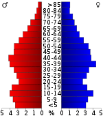
In the county, the population was spread out, with 25.90% under the age of 18, 8.00% from 18 to 24, 29.60% from 25 to 44, 24.30% from 45 to 64, and 12.20% who were 65 years of age or older. The median age was 37 years. For every 100 females, there were 98.50 males. For every 100 females age 18 and over, there were 96.30 males.
The median income for a household in the county was $37,182, and the median income for a family was $42,901. Males had a median income of $31,842 versus $22,098 for females. The per capita income for the county was $17,547. About 7.80% of families and 10.20% of the population were below the poverty line, including 12.50% of those under age 18 and 13.00% of those age 65 or over.
Government
Over The past few election cycles Grant county has trended heavily towards the GOP. The last democrat (as of 2016) to carry this county was Bill Clinton in 1996.
| Year | GOP | Dem | Others |
|---|---|---|---|
| 2016 | 76.90% 5,725 | 18.44% 1,373 | 4.67% 347 |
| 2012 | 74.53% 4,829 | 22.66% 1,468 | 2.81% 182 |
| 2008 | 73.94% 5,023 | 22.99% 1,562 | 3.06% 208 |
| 2004 | 62.11% 4,205 | 37.28% 2,524 | 0.61% 41 |
| 2000 | 54.63% 3,285 | 42.16% 2,535 | 3.21% 193 |
| 1996 | 34.77% 1,925 | 53.25% 2,948 | 11.97% 663 |
| 1992 | 36.66% 2,272 | 51.47% 3,190 | 11.88% 736 |
| 1988 | 55.40% 2,717 | 43.68% 2,142 | 0.92% 45 |
| 1984 | 59.16% 3,167 | 40.13% 2,148 | 0.71% 38 |
| 1980 | 38.04% 2,007 | 58.34% 3,078 | 3.62% 191 |
| 1976 | 21.61% 1,047 | 78.39% 3,797 | 0.00% 0 |
| 1972 | 67.41% 2,414 | 32.03% 1,147 | 0.56% 20 |
| 1968 | 17.07% 627 | 23.20% 852 | 59.73% 2,194 |
| 1964 | 42.93% 1,308 | 55.07% 1,678 | 2.00% 61 |
| 1960 | 24.81% 563 | 61.44% 1,394 | 13.75% 312 |
| 1956 | 38.24% 818 | 59.47% 1,272 | 2.29% 49 |
| 1952 | 29.84% 637 | 69.65% 1,487 | 0.52% 11 |
| 1948 | 9.80% 121 | 71.50% 883 | 18.70% 231 |
| 1944 | 23.49% 334 | 76.51% 1,088 | 0.00% 0 |
| 1940 | 13.30% 160 | 86.70% 1,043 | 0.00% 0 |
| 1936 | 13.06% 147 | 86.86% 978 | 0.09% 1 |
| 1932 | 3.26% 55 | 96.50% 1,626 | 0.24% 4 |
| 1928 | 29.54% 439 | 70.32% 1,045 | 0.13% 2 |
| 1924 | 15.50% 133 | 73.19% 628 | 11.31% 97 |
| 1920 | 26.59% 230 | 71.56% 619 | 1.85% 16 |
| 1916 | 16.56% 190 | 83.44% 957 | 0.00% 0 |
| 1912 | 17.68% 110 | 70.74% 440 | 11.58% 72 |
| 1908 | 21.28% 160 | 69.68% 524 | 9.04% 68 |
| 1904 | 26.96% 151 | 72.50% 406 | 0.54% 3 |
| 1900 | 23.36% 175 | 76.64% 574 | 0.00% 0 |
| 1896 | 13.43% 125 | 86.04% 801 | 0.54% 5 |
Communities
Cities
- Leola
- Prattsville
- Sheridan (county seat)
Townships
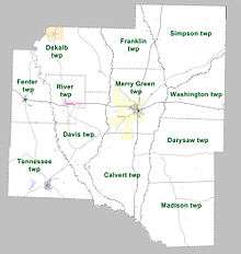
Townships in Arkansas are the divisions of a county. Each township includes unincorporated areas; some may have incorporated cities or towns within part of their boundaries. Arkansas townships have limited purposes in modern times. However, the United States Census does list Arkansas population based on townships (sometimes referred to as "county subdivisions" or "minor civil divisions"). Townships are also of value for historical purposes in terms of genealogical research. Each town or city is within one or more townships in an Arkansas county based on census maps and publications. The townships of Grant County are listed below; listed in parentheses are the cities, towns, and/or census-designated places that are fully or partially inside the township. [15][16]
Culture
Grant County is home to Jenkins' Ferry Battleground State Park.[17]
See also
- List of dry counties in Arkansas
- List of counties in Arkansas
- List of lakes in Grant County, Arkansas
- National Register of Historic Places listings in Grant County, Arkansas
References
- "State & County QuickFacts". United States Census Bureau. Archived from the original on June 7, 2011. Retrieved May 21, 2014.
- "Find a County". National Association of Counties. Archived from the original on 2011-05-31. Retrieved 2011-06-07.
- Gannett, Henry (1905). The Origin of Certain Place Names in the United States. Govt. Print. Off. pp. 141.
- "Grant County". Local.Arkansas.gov. Information Network of Arkansas (INA) and Arkansas Municipal League. 2012. Retrieved 2012-05-05.
- "ASU-Jonesboro: Act 100 Re-enactment Ceremony". astate.edu. Archived from the original on January 16, 2011. Retrieved July 5, 2011.
- "2010 Census Gazetteer Files". United States Census Bureau. August 22, 2012. Retrieved August 26, 2015.
- "Population and Housing Unit Estimates". Retrieved September 28, 2019.
- "U.S. Decennial Census". United States Census Bureau. Retrieved August 26, 2015.
- "Historical Census Browser". University of Virginia Library. Retrieved August 26, 2015.
- Forstall, Richard L., ed. (March 27, 1995). "Population of Counties by Decennial Census: 1900 to 1990". United States Census Bureau. Retrieved August 26, 2015.
- "Census 2000 PHC-T-4. Ranking Tables for Counties: 1990 and 2000" (PDF). United States Census Bureau. April 2, 2001. Retrieved August 26, 2015.
- Based on 2000 census data
- "U.S. Census website". United States Census Bureau. Retrieved 2011-05-14.
- "Dave Leip's Atlas of U.S. Presidential Elections". Retrieved November 18, 2016.
- 2011 Boundary and Annexation Survey (BAS): Grant County, AR (PDF) (Map). U. S. Census Bureau. Archived from the original (PDF) on 2012-10-19. Retrieved 2011-08-14.
- "Arkansas: 2010 Census Block Maps - County Subdivision". United States Census Bureau. Retrieved May 28, 2014.
- "Jenkins' Ferry Battleground State Park". Arkansas Department of Parks and Tourism. Retrieved February 2, 2018.
| Wikimedia Commons has media related to Grant County, Arkansas. |
Places adjacent to Grant County, Arkansas | ||||||||||
|---|---|---|---|---|---|---|---|---|---|---|
| ||||||||||
Municipalities and communities of Grant County, Arkansas, United States | ||
|---|---|---|
| Cities | Map of Arkansas highlighting Grant County | |
| Towns | ||
| Unincorporated community | ||

| Authority control |
|
|---|