Benton County, Arkansas
Benton County is a county located in the northwestern corner of the U.S. state of Arkansas. As of the 2010 census, the population was 221,339,[1] making it the second-most populous county in Arkansas. The county seat is Bentonville.[2] The county was formed on September 30, 1836 and was named after Thomas Hart Benton, a U.S. Senator from Missouri. In 2012, Benton County voters elected to make the county wet, or a non-alcohol prohibition location.[3] Benton County is part of the Northwest Arkansas region.
Benton County | |
|---|---|
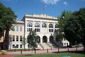 Benton County Courthouse, July 2011 | |
 Flag  Seal | |
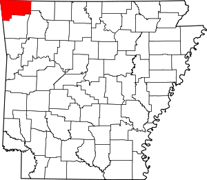 Location within the U.S. state of Arkansas | |
 Arkansas's location within the U.S. | |
| Coordinates: 36°21′08″N 94°14′03″W | |
| Country | |
| State | |
| Founded | September 30, 1836 |
| Named for | Thomas Hart Benton |
| Seat | Bentonville |
| Largest city | Rogers |
| Area | |
| • Total | 884 sq mi (2,290 km2) |
| • Land | 847 sq mi (2,190 km2) |
| • Water | 37 sq mi (100 km2) 4.1%% |
| Population (2010) | |
| • Total | 221,339 |
| • Estimate (2019) | 279,141 |
| • Density | 250/sq mi (97/km2) |
| Time zone | UTC−6 (Central) |
| • Summer (DST) | UTC−5 (CDT) |
| Congressional district | 3rd |
| Website | www |
Geography
According to the U.S. Census Bureau, the county has a total area of 884 square miles (2,290 km2), of which 847 square miles (2,190 km2) is land and 37 square miles (96 km2) (4.1%) is water.[4] Most of the water is in Beaver Lake.
Adjacent counties
- Barry County, Missouri (north)
- Carroll County (east)
- Madison County (southeast)
- Washington County (south)
- Adair County, Oklahoma (southwest)
- Delaware County, Oklahoma (west)
- McDonald County, Missouri (northwest)
National protected areas
- Logan Cave National Wildlife Refuge
- Ozark National Forest (part)
- Pea Ridge National Military Park
Demographics
| Historical population | |||
|---|---|---|---|
| Census | Pop. | %± | |
| 1840 | 2,228 | — | |
| 1850 | 3,710 | 66.5% | |
| 1860 | 9,306 | 150.8% | |
| 1870 | 13,831 | 48.6% | |
| 1880 | 20,328 | 47.0% | |
| 1890 | 27,716 | 36.3% | |
| 1900 | 31,611 | 14.1% | |
| 1910 | 33,389 | 5.6% | |
| 1920 | 36,253 | 8.6% | |
| 1930 | 35,253 | −2.8% | |
| 1940 | 36,148 | 2.5% | |
| 1950 | 38,076 | 5.3% | |
| 1960 | 36,272 | −4.7% | |
| 1970 | 50,476 | 39.2% | |
| 1980 | 78,115 | 54.8% | |
| 1990 | 97,499 | 24.8% | |
| 2000 | 153,406 | 57.3% | |
| 2010 | 221,339 | 44.3% | |
| Est. 2019 | 279,141 | [5] | 26.1% |
| U.S. Decennial Census[6] 1790–1960[7] 1900–1990[8] 1990–2000[9] 2010–2019[1] | |||
As of the 2000 United States Census,[11] there were 153,406 people, 58,212 households, and 43,484 families residing in the county. The population density was 181 people per square mile (70/km²). There were 64,281 housing units at an average density of 76 per square mile (29/km²). The racial makeup of the county was 90.87% White, 0.41% Black or African American, 1.65% Native American, 1.09% Asian, 0.08% Pacific Islander, 4.08% from other races, and 1.82% from two or more races. 8.78% of the population were Hispanic or Latino of any race.
As of 2005 estimates, Benton County's population was 81.7% non-Hispanic white, while the percentage of Latinos grew by 60 percent in the time period. 1.1% of the population was African-American; 1.6% was Native American (the historical presence of the Cherokee Indians live in close proximity to Oklahoma); 1.7% was Asian (there was a large influx of Filipinos, Vietnamese and South Asian immigrants in recent decades) and 0.2% of the population was Pacific Islander. 1.6% reported two or more races, usually not black-white due to a minuscule African-American population. 12.8% was Latino, but the United States Hispanic Chamber of Commerce believed the official estimate is underreported and Latinos could well be 20 percent of the population.[12]
There were 58,212 households out of which 34.40% had children under the age of 18 living with them, 63.00% were married couples living together, 8.20% had a female householder with no husband present, and 25.30% were non-families. 21.10% of all households were made up of individuals and 8.50% had someone living alone who was 65 years of age or older. The average household size was 2.60 and the average family size was 3.01.
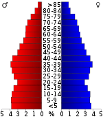
In the county, the population was spread out with 26.60% under the age of 18, 8.60% from 18 to 24, 29.40% from 25 to 44, 21.10% from 45 to 64, and 14.30% who were 65 years of age or older. The median age was 35 years. For every 100 females, there were 97.40 males. For every 100 females age 18 and over, there were 94.90 males.
The median income for a household in the county was $40,281, and the median income for a family was $45,235. Males had a median income of $30,327 versus $22,469 for females. The per capita income for the county was $19,377. About 7.30% of families and 10.10% of the population were below the poverty line, including 13.80% of those under age 18 and 7.30% of those age 65 or over.
As of the 2010 census, the county population was 221,339. The racial makeup of the county was 76.18% Non-Hispanic white, 1.27% Black or African American, 1.69% Native American, 2.85% Asian, 0.30% Pacific Islander. 15.49% of the population was Hispanic or Latino.[13]
Politically, Benton County is arguably one of the most Republican-Leaning Counties in Arkansas. Benton County has not voted completely Democrat in a Presidential election since 1948, when former Missouri senator Harry S. Truman won Benton County along with winning Arkansas as a whole.[14]
Economy
- Walmart corporate headquarters is located in Bentonville.
- Daisy Outdoor Products, known for its air rifles, is headquartered in Rogers.
- JB Hunt Transport Services corporate headquarters is located in Lowell.
- Tyson Foods, based in Springdale, has a distribution center located in Rogers.
Transportation
Major highways
.svg.png)


The historic Trail of Tears is on US highways 62 and 71 and connects with U.S. Route 412 in nearby Washington County.
Airports
- Northwest Arkansas Regional Airport (XNA) is located near Highfill.
- Rogers Municipal Airport (ROG) serves the county and surrounding communities.
Rail
The Arkansas and Missouri Railroad parallels US Highways 62 and 71 in the county.
Politics
Like all of the conservative Bible Belt of the Ozarks and Ouachitas, Benton County is strongly Republican; however, it has been such for longer than most of the region. It voted Republican in 1928 and 1944, and the last Democratic presidential nominee to carry the county was Harry S. Truman in 1948.[15] Along with nearby Sebastian County it was one of the few counties in Arkansas to resist the appeal of southern “favorite sons” Lyndon B. Johnson, George Wallace, Jimmy Carter and Bill Clinton.
| Year | GOP | Dem | Others |
|---|---|---|---|
| 2016 | 62.87% 60,871 | 28.92% 28,005 | 8.21% 7,948 |
| 2012 | 68.95% 54,646 | 28.56% 22,636 | 2.49% 1,975 |
| 2008 | 67.20% 51,124 | 30.67% 23,331 | 2.13% 1,618 |
| 2004 | 68.37% 46,571 | 30.47% 20,756 | 1.17% 794 |
| 2000 | 64.94% 34,838 | 32.21% 17,277 | 2.86% 1,531 |
| 1996 | 51.89% 23,748 | 37.59% 17,205 | 10.52% 4,815 |
| 1992 | 48.81% 21,126 | 36.45% 15,774 | 14.74% 6,379 |
| 1988 | 71.23% 24,295 | 27.55% 9,399 | 1.22% 416 |
| 1984 | 75.90% 24,296 | 22.82% 7,306 | 1.27% 408 |
| 1980 | 63.96% 18,830 | 31.36% 9,231 | 4.69% 1,379 |
| 1976 | 52.75% 12,670 | 47.00% 11,289 | 0.25% 61 |
| 1972 | 77.86% 14,621 | 21.74% 4,083 | 0.39% 74 |
| 1968 | 49.94% 8,104 | 25.19% 4,088 | 24.87% 4,036 |
| 1964 | 51.25% 5,977 | 48.49% 5,655 | 0.26% 30 |
| 1960 | 67.58% 7,832 | 31.23% 3,619 | 1.20% 139 |
| 1956 | 63.08% 6,500 | 36.33% 3,744 | 0.59% 61 |
| 1952 | 68.83% 7,916 | 30.94% 3,558 | 0.23% 26 |
| 1948 | 44.70% 2,911 | 50.38% 3,281 | 4.93% 321 |
| 1944 | 53.52% 3,305 | 46.33% 2,861 | 0.15% 9 |
| 1940 | 43.86% 1,962 | 54.59% 2,442 | 1.54% 69 |
| 1936 | 40.64% 1,672 | 58.77% 2,418 | 0.58% 24 |
| 1932 | 24.53% 1,275 | 72.62% 3,775 | 2.85% 148 |
| 1928 | 57.29% 3,248 | 41.42% 2,348 | 1.29% 73 |
| 1924 | 37.04% 1,694 | 50.58% 2,313 | 12.38% 566 |
| 1920 | 39.34% 1,916 | 58.28% 2,838 | 2.38% 116 |
| 1916 | 29.39% 1,293 | 70.61% 3,106 | 0.00% 0 |
| 1912 | 14.05% 541 | 61.12% 2,353 | 24.83% 956 |
| 1908 | 31.77% 1,527 | 63.82% 3,067 | 4.41% 212 |
| 1904 | 35.08% 1,202 | 57.30% 1,963 | 7.62% 261 |
| 1900 | 26.36% 1,087 | 72.28% 2,980 | 1.36% 56 |
| 1896 | 16.05% 685 | 83.15% 3,548 | 0.80% 34 |
Communities
Cities
- Bella Vista
- Bentonville (county seat)
- Bethel Heights
- Cave Springs
- Centerton
- Decatur
- Elm Springs (mostly in Washington County)
- Gentry
- Gravette
- Little Flock
- Lowell
- Pea Ridge
- Rogers
- Siloam Springs
- Springdale (mostly in Washington County)
- Sulphur Springs
Towns
Census-designated places
- Cherokee City
- Hiwasse (former CDP)
- Lost Bridge Village
- Maysville
- Prairie Creek
Townships
Note: Most Arkansas counties have names for their townships. Benton County, however, has numbers instead of names.
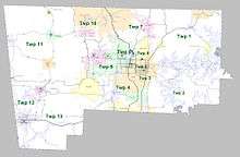
Townships in Arkansas are the divisions of a county. Each township includes unincorporated areas; some may have incorporated cities or towns within part of their boundaries. Arkansas townships have limited purposes in modern times. However, the United States Census does list Arkansas population based on townships (sometimes referred to as "county subdivisions" or "minor civil divisions"). Townships are also of value for historical purposes in terms of genealogical research. Each town or city is within one or more townships in an Arkansas county based on census maps and publications. The townships of Benton County are listed below; listed in parentheses are the cities, towns, and/or census-designated places that are fully or partially inside the township.[17][18]
| Township | FIPS code | ANSI code (GNIS ID) |
Population center(s) |
Pop. (2010) |
Pop. density (/mi²) |
Pop. density (/km²) |
Total area (mi²) |
Total area (km²) |
Land area (mi²) |
Land area (km²) |
Water area (mi²) |
Water area (km²) |
Geographic coordinates |
|---|---|---|---|---|---|---|---|---|---|---|---|---|---|
| Township 1 | 05-93626 | 01989186 | all of: Garfield, Gateway, Lost Bridge Village, Prairie Creek; parts of: Avoca, Rogers | 13,223 | 113.79 | 43.93 | 130.964 | 339.2 | 116.205 | 301.0 | 14.759 | 38.23 | 36.412328°N 93.979817°W |
| Township 2 | 05-93628 | 01989194 | small parts of: Lowell, Rogers, Springdale | 14,279 | 150.33 | 58.04 | 111.844 | 289.7 | 94.984 | 246.0 | 16.860 | 43.67 | 36.280449°N 93.983324°W |
| Township 3 | 05-93630 | 01989187 | parts of: Lowell, Rogers, Springdale; most of Bethel Heights | 20,037 | 1,903.93 | 735.03 | 10.572 | 27.38 | 10.524 | 27.26 | 0.048 | 0.1243 | 36.272833°N 94.124961°W |
| Township 4 | 05-93632 | 01989188 | all of Cave Springs ; most of the following: Lowell, Rogers, Springdale (within Benton County); small parts of Elm Springs | 25,596 | 518.70 | 200.28 | 49.693 | 128.7 | 49.346 | 127.8 | 0.347 | 0.8987 | 36.271000°N 94.192603°W |
| Township 5 | 05-93634 | 01989189 | part of Rogers | 12,792 | 2,873.32 | 1,109.45 | 4.460 | 11.55 | 4.452 | 11.53 | 0.008 | 0.02072 | 36.335732°N 94.140417°W |
| Township 6 | 05-93636 | 01989190 | most of Little Flock; almost half of Avoca; small parts of Bentonville, Pea Ridge, Rogers | 14,033 | 671.18 | 259.15 | 20.929 | 54.21 | 20.908 | 54.15 | 0.021 | 0.05439 | 36.380291°N 94.128869°W |
| Township 7 | 05-93638 | 01989191 | most of Pea Ridge; part of Bella Vista; small part of Bentonville | 20,317 | 331.80 | 128.10 | 61.597 | 159.5 | 61.233 | 158.6 | 0.364 | 0.9428 | 36.454130°N 94.153613°W |
| Township 8 | 05-93640 | 01989192 | part of Bentonville | 12,637 | 1,575.69 | 608.43 | 8.028 | 20.79 | 8.020 | 20.77 | 0.008 | 0.02072 | 36.380199°N 94.200482°W |
| Township 9 | 05-93642 | 01989193 | most of: Bentonville, Centerton; small part of Highfill | 31,362 | 638.18 | 246.36 | 49.497 | 128.2 | 49.143 | 127.3 | 0.354 | 0.9169 | 36.354443°N 94.269172°W |
| Township 10 | 05-93644 | 01989195 | most of: Bella Vista, Hiwasse | 16,402 | 385.73 | 148.97 | 43.848 | 113.6 | 42.522 | 110.1 | 1.326 | 3.434 | 36.453560°N 94.307978°W |
| Township 11 | 05-93645 | 01989196 | all of: Cherokee City, Decatur, Gravette, Maysville, Sulphur Springs; small parts of: Centerton, Highfill, Hiwasse | 12,273 | 59.13 | 22.83 | 207.804 | 538.2 | 207.558 | 537.6 | 0.246 | 0.6371 | 36.393573°N 94.468392°W |
| Township 12 | 05-93646 | 01989197 | most of Gentry; more than half of Siloam Springs | 15,158 | 361.65 | 139.58 | 43.028 | 111.4 | 41.913 | 108.6 | 1.115 | 2.888 | 36.239052°N 94.522847°W |
| Township 13 | 05-93647 | 01989198 | all of Springtown; most of Highfill; small parts of: Elm Springs, Gentry, Springdale | 13,230 | 94.13 | 36.35 | 141.642 | 366.9 | 140.548 | 364.0 | 1.094 | 2.833 | 36.193862°N 94.409806°W |
| Source: "Census 2010 U.S. Gazetteer Files: County Subdivisions in Arkansas". U.S. Census Bureau, Geography Division. Archived from the original on May 31, 2014.
Source: "Census 2010 U.S. Gazetteer Files". U.S. Census Bureau, Geography Division. | |||||||||||||
See also
- List of lakes in Benton County, Arkansas
- National Register of Historic Places listings in Benton County, Arkansas
References
- "State & County QuickFacts". United States Census Bureau. Archived from the original on July 7, 2011. Retrieved May 19, 2014.
- "Find a County". National Association of Counties. Archived from the original on May 31, 2011. Retrieved June 7, 2011.
- "Jordan wins in Fayetteville, Benton County goes wet". Archived from the original on March 7, 2013. Retrieved March 16, 2013.
- "2010 Census Gazetteer Files". United States Census Bureau. August 22, 2012. Retrieved August 25, 2015.
- "County Population Totals and Components of Change: 2010-2019". United States Census Bureau. Retrieved March 28, 2020.
- "U.S. Decennial Census". United States Census Bureau. Retrieved August 25, 2015.
- "Historical Census Browser". University of Virginia Library. Retrieved August 25, 2015.
- Forstall, Richard L., ed. (March 27, 1995). "Population of Counties by Decennial Census: 1900 to 1990". United States Census Bureau. Retrieved August 25, 2015.
- "Census 2000 PHC-T-4. Ranking Tables for Counties: 1990 and 2000" (PDF). United States Census Bureau. April 2, 2001. Retrieved August 25, 2015.
- Based on 2000 census data
- "U.S. Census website". United States Census Bureau. Retrieved May 14, 2011.
- "Benton County QuickFacts from the U. S. Census Bureau". Archived from the original on July 7, 2011. Retrieved August 6, 2007.
- "Population estimates, July 1, 2015, (V2015)". www.census.gov. Retrieved June 27, 2016.
- Leip, David. "1948 Presidential General Election Results".
- Sullivan, Robert David; ‘How the Red and Blue Map Evolved Over the Past Century’; America Magazine in The National Catholic Review; June 29, 2016
- "Dave Leip's Atlas of U.S. Presidential Elections". Retrieved November 18, 2016.
- 2011 Boundary and Annexation Survey (BAS): Benton County, AR (PDF) (Map). U. S. Census Bureau. Archived from the original (PDF) on October 19, 2012. Retrieved August 8, 2011.
- "Arkansas: 2010 Census Block Maps - County Subdivision". United States Census Bureau. Retrieved June 28, 2014.
External links
Places adjacent to Benton County, Arkansas | |
|---|---|
Municipalities and communities of Benton County, Arkansas, United States | ||
|---|---|---|
| Cities | Map of Arkansas highlighting Benton County | |
| Towns | ||
| Townships | ||
| CDPs | ||
| Other communities |
| |
| Ghost towns | ||
| Footnotes | ‡This populated place also has portions in an adjacent county or counties | |

| Authority control |
|
|---|