Scott County, Arkansas
Scott County is a county located in the U.S. state of Arkansas. As of the 2010 census, the population was 11,233.[1] The county seat is Waldron.[2] Scott County is Arkansas' 28th county, formed on November 5, 1833,[3] and named for Andrew Scott, a justice of the Supreme Court of the Arkansas Territory.[4] It is an alcohol-prohibited or dry county. Scott County is represented the Arkansas House of Representatives by the Republicans Marcus Richmond, a businessman from Harvey, and Jon Eubanks, a farmer and Certified Public Accountant from Paris.
Scott County | |
|---|---|
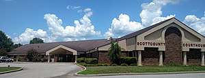 Scott County Courthouse in Waldron | |
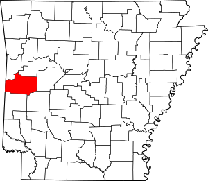 Location within the U.S. state of Arkansas | |
 Arkansas's location within the U.S. | |
| Coordinates: 34°52′49″N 94°04′15″W | |
| Country | |
| State | |
| Founded | November 5, 1833 |
| Named for | Andrew Scott |
| Seat | Waldron |
| Largest city | Waldron |
| Area | |
| • Total | 898 sq mi (2,330 km2) |
| • Land | 892 sq mi (2,310 km2) |
| • Water | 5.8 sq mi (15 km2) 0.6%% |
| Population (2010) | |
| • Total | 11,233 |
| • Estimate (2019) | 10,281 |
| • Density | 13/sq mi (4.8/km2) |
| Time zone | UTC−6 (Central) |
| • Summer (DST) | UTC−5 (CDT) |
| Congressional district | 4th |
Geography
According to the U.S. Census Bureau, the county has a total area of 898 square miles (2,330 km2), of which 892 square miles (2,310 km2) is land and 5.8 square miles (15 km2) (0.6%) is water.[5]
Major highways
.svg.png)


Adjacent counties
- Sebastian County (northwest)
- Logan County (northeast)
- Yell County (east)
- Montgomery County (southeast)
- Polk County (south)
- Le Flore County, Oklahoma (west)
National protected area
- Ouachita National Forest (part)
Demographics
| Historical population | |||
|---|---|---|---|
| Census | Pop. | %± | |
| 1840 | 1,694 | — | |
| 1850 | 3,083 | 82.0% | |
| 1860 | 5,145 | 66.9% | |
| 1870 | 7,483 | 45.4% | |
| 1880 | 9,174 | 22.6% | |
| 1890 | 12,635 | 37.7% | |
| 1900 | 13,183 | 4.3% | |
| 1910 | 14,302 | 8.5% | |
| 1920 | 13,232 | −7.5% | |
| 1930 | 11,803 | −10.8% | |
| 1940 | 13,300 | 12.7% | |
| 1950 | 10,057 | −24.4% | |
| 1960 | 7,297 | −27.4% | |
| 1970 | 8,207 | 12.5% | |
| 1980 | 9,685 | 18.0% | |
| 1990 | 10,205 | 5.4% | |
| 2000 | 10,996 | 7.8% | |
| 2010 | 11,233 | 2.2% | |
| Est. 2019 | 10,281 | [6] | −8.5% |
| U.S. Decennial Census[7] 1790–1960[8] 1900–1990[9] 1990–2000[10] 2010–2016[1] | |||
As of the 2000 census,[12] there were 10,996 people, 4,323 households, and 3,121 families residing in the county. The population density was 12 people per square mile (5/km²). There were 4,924 housing units at an average density of 6 per square mile (2/km²). The racial makeup of the county was 93.53% White, 0.23% Black or African American, 1.40% Native American, 0.95% Asian, 0.01% Pacific Islander, 2.56% from other races, and 1.32% from two or more races. 5.71% of the population were Hispanic or Latino of any race.
There were 4,323 households out of which 32.6% had children under the age of 18 living with them, 59.5% were married couples living together, 8.5% had a female householder with no husband present, and 27.8% were non-families. 24.8% of all households were made up of individuals and 11.4% had someone living alone who was 65 years of age or older. The average household size was 2.52 and the average family size was 2.98.
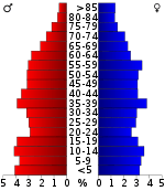
In the county, the population was spread out with 26.5% under the age of 18, 8.1% from 18 to 24, 26.5% from 25 to 44, 24.2% from 45 to 64, and 14.7% who were 65 years of age or older. The median age was 37 years. For every 100 females there were 101.9 males. For every 100 females age 18 and over, there were 96.6 males.
The median income for a household in the county was $26,412, and the median income for a family was $30,311. Males had a median income of $23,118 versus $17,127 for females. The per capita income for the county was $13,609. About 15.3% of families and 18.2% of the population were below the poverty line, including 21.2% of those under age 18 and 14.1% of those age 65 or over.
As of 2010 Scott County had a population of 11,233. The racial makeup was 85.35% white, 0.47% black, 1.85% Native American, 3.42% Asian, 2.12% Non-Hispanics reporting more than one race and 6.96% Hispanics or Latinos.
Government
Over the past few election cycles Scott County has trended heavily towards the GOP. The last Democrat (as of 2016) to carry this county was Bill Clinton in 1996.
| Year | GOP | Dem | Others |
|---|---|---|---|
| 2016 | 77.81% 2,731 | 17.15% 602 | 5.05% 177 |
| 2012 | 72.28% 2,631 | 24.64% 897 | 3.08% 112 |
| 2008 | 69.86% 2,791 | 26.36% 1,053 | 3.78% 151 |
| 2004 | 62.26% 2,514 | 36.48% 1,473 | 1.26% 51 |
| 2000 | 60.26% 2,399 | 36.27% 1,444 | 3.47% 138 |
| 1996 | 33.19% 1,426 | 52.57% 2,259 | 14.24% 612 |
| 1992 | 37.15% 1,695 | 48.84% 2,228 | 14.01% 639 |
| 1988 | 58.82% 2,507 | 40.05% 1,707 | 1.13% 48 |
| 1984 | 65.11% 3,066 | 34.17% 1,609 | 0.72% 34 |
| 1980 | 48.16% 2,228 | 48.34% 2,236 | 3.50% 162 |
| 1976 | 33.09% 1,427 | 66.79% 2,880 | 0.12% 5 |
| 1972 | 75.87% 2,424 | 24.13% 771 | 0.00% 0 |
| 1968 | 34.18% 1,162 | 29.41% 1,000 | 36.41% 1,238 |
| 1964 | 37.82% 1,121 | 62.01% 1,838 | 0.17% 5 |
| 1960 | 50.22% 1,137 | 49.29% 1,116 | 0.49% 11 |
| 1956 | 56.47% 1,637 | 43.05% 1,248 | 0.48% 14 |
| 1952 | 42.50% 893 | 56.97% 1,197 | 0.52% 11 |
| 1948 | 18.47% 260 | 77.63% 1,093 | 3.91% 55 |
| 1944 | 27.93% 348 | 72.07% 898 | 0.00% 0 |
| 1940 | 26.09% 353 | 73.32% 992 | 0.59% 8 |
| 1936 | 24.17% 363 | 75.70% 1,137 | 0.13% 2 |
| 1932 | 13.26% 174 | 79.42% 1,042 | 7.32% 96 |
| 1928 | 38.85% 573 | 60.41% 891 | 0.75% 11 |
| 1924 | 33.24% 375 | 53.81% 607 | 12.94% 146 |
| 1920 | 46.88% 751 | 48.13% 771 | 4.99% 80 |
| 1916 | 27.30% 514 | 72.70% 1,369 | 0.00% 0 |
| 1912 | 16.60% 206 | 51.57% 640 | 31.83% 395 |
| 1908 | 30.12% 481 | 55.92% 893 | 13.96% 223 |
| 1904 | 45.26% 458 | 45.26% 458 | 9.49% 96 |
| 1900 | 29.39% 313 | 68.83% 733 | 1.78% 19 |
| 1896 | 16.91% 264 | 80.72% 1,260 | 2.37% 37 |
Communities
Townships
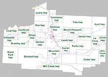
Townships in Arkansas are the divisions of a county. Each township includes unincorporated areas; some may have incorporated cities or towns within part of their boundaries. Arkansas townships have limited purposes in modern times. However, the United States Census does list Arkansas population based on townships (sometimes referred to as "county subdivisions" or "minor civil divisions"). Townships are also of value for historical purposes in terms of genealogical research. Each town or city is within one or more townships in an Arkansas county based on census maps and publications. The townships of Scott County are listed below; listed in parentheses are the cities, towns, and/or census-designated places that are fully or partially inside the township. [14][15]
See also
- List of lakes in Scott County, Arkansas
- National Register of Historic Places listings in Scott County, Arkansas
References
- "State & County QuickFacts". United States Census Bureau. Retrieved May 24, 2014.
- "Find a County". National Association of Counties. Retrieved 2011-06-07.
- Biographical and Historical Memoirs of Western Arkansas. Chicago, IL: Southern Publishing Company. 1891. p. 388. Retrieved 2012-05-12.
- McCutchen, Henry Grady (1922). History of Scott County, Arkansas. 22.
- "2010 Census Gazetteer Files". United States Census Bureau. August 22, 2012. Retrieved August 27, 2015.
- "Population and Housing Unit Estimates". Retrieved September 28, 2019.
- "U.S. Decennial Census". United States Census Bureau. Retrieved August 27, 2015.
- "Historical Census Browser". University of Virginia Library. Retrieved August 27, 2015.
- Forstall, Richard L., ed. (March 27, 1995). "Population of Counties by Decennial Census: 1900 to 1990". United States Census Bureau. Retrieved August 27, 2015.
- "Census 2000 PHC-T-4. Ranking Tables for Counties: 1990 and 2000" (PDF). United States Census Bureau. April 2, 2001. Retrieved August 27, 2015.
- Based on 2000 census data
- "U.S. Census website". United States Census Bureau. Retrieved 2011-05-14.
- "Dave Leip's Atlas of U.S. Presidential Elections". Retrieved November 18, 2016.
- 2011 Boundary and Annexation Survey (BAS): Scott County, AR (PDF) (Map). U. S. Census Bureau. Archived from the original (PDF) on 2012-10-19. Retrieved 2011-08-11.
- "Arkansas: 2010 Census Block Maps - County Subdivision". United States Census Bureau. Retrieved May 29, 2014.
External links
- Scott County, Arkansas entry on the Encyclopedia of Arkansas History & Culture
- Scott County official website
Places adjacent to Scott County, Arkansas | ||||||||||
|---|---|---|---|---|---|---|---|---|---|---|
| ||||||||||
Municipalities and communities of Scott County, Arkansas, United States | ||
|---|---|---|
| Cities | Map of Arkansas highlighting Scott County | |
| Unincorporated communities | ||
| Ghost towns | ||
| Footnotes | ‡This populated place also has portions in an adjacent county or counties | |

| Authority control |
|
|---|