Independence County, Arkansas
Independence County is a county located in the U.S. state of Arkansas. As of the 2010 census, the population was 36,647.[1] The county seat is Batesville.[2] Independence County is Arkansas's ninth county, formed on October 20, 1820, from a portion of Lawrence County and named in commemoration of the Declaration of Independence.[3] It is an alcohol prohibition or dry county.
Independence County | |
|---|---|
 | |
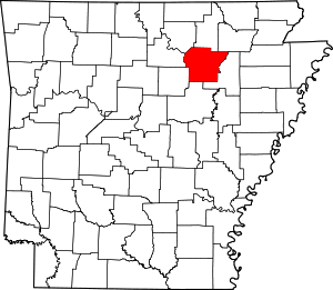 Location within the U.S. state of Arkansas | |
 Arkansas's location within the U.S. | |
| Coordinates: 35°43′23″N 91°31′14″W | |
| Country | |
| State | |
| Founded | October 20, 1820 |
| Named for | Declaration of Independence |
| Seat | Batesville |
| Largest city | Batesville |
| Area | |
| • Total | 772 sq mi (2,000 km2) |
| • Land | 764 sq mi (1,980 km2) |
| • Water | 7.6 sq mi (20 km2) 1.0%% |
| Population (2010) | |
| • Total | 36,647 |
| • Estimate (2019) | 37,825 |
| • Density | 47/sq mi (18/km2) |
| Time zone | UTC−6 (Central) |
| • Summer (DST) | UTC−5 (CDT) |
| Congressional district | 1st |
| Website | www |
The Batesville, AR Micropolitan Statistical Area includes all of Independence County.
Geography
According to the U.S. Census Bureau, the county has a total area of 772 square miles (2,000 km2), of which 764 square miles (1,980 km2) is land and 7.6 square miles (20 km2) (1.0%) is water.[4]
List of highways


Adjacent counties
- Sharp County (north)
- Lawrence County (northeast)
- Jackson County (east)
- White County (south)
- Cleburne County (southwest)
- Stone County (west)
- Izard County (northwest)
Demographics
| Historical population | |||
|---|---|---|---|
| Census | Pop. | %± | |
| 1830 | 2,031 | — | |
| 1840 | 3,669 | 80.6% | |
| 1850 | 7,767 | 111.7% | |
| 1860 | 14,307 | 84.2% | |
| 1870 | 14,566 | 1.8% | |
| 1880 | 18,086 | 24.2% | |
| 1890 | 21,961 | 21.4% | |
| 1900 | 22,557 | 2.7% | |
| 1910 | 24,776 | 9.8% | |
| 1920 | 23,976 | −3.2% | |
| 1930 | 24,225 | 1.0% | |
| 1940 | 25,643 | 5.9% | |
| 1950 | 23,488 | −8.4% | |
| 1960 | 20,048 | −14.6% | |
| 1970 | 22,723 | 13.3% | |
| 1980 | 30,147 | 32.7% | |
| 1990 | 31,192 | 3.5% | |
| 2000 | 34,233 | 9.7% | |
| 2010 | 36,647 | 7.1% | |
| Est. 2019 | 37,825 | [5] | 3.2% |
| U.S. Decennial Census[6] 1790–1960[7] 1900–1990[8] 1990–2000[9] 2010–2016[1] | |||

As of the 2000 census,[11] there were 34,233 people, 13,467 households, and 9,669 families residing in the county. The population density was 45 people per square mile (17/km²). There were 14,841 housing units at an average density of 19 per square mile (8/km²). The racial makeup of the county was 94.91% White, 2.04% Black or African American, 0.45% Native American, 0.65% Asian, 0.03% Pacific Islander, 0.64% from other races, and 1.28% from two or more races. 1.53% of the population were Hispanic or Latino of any race.
There were 13,467 households out of which 32.10% had children under the age of 18 living with them, 59.00% were married couples living together, 9.20% had a female householder with no husband present, and 28.20% were non-families. 25.50% of all households were made up of individuals and 11.70% had someone living alone who was 65 years of age or older. The average household size was 2.47 and the average family size was 2.95.
In the county, the population was spread out with 24.50% under the age of 18, 9.20% from 18 to 24, 27.70% from 25 to 44, 24.10% from 45 to 64, and 14.50% who were 65 years of age or older. The median age was 38 years. For every 100 females there were 96.30 males. For every 100 females age 18 and over, there were 92.60 males.
The median income for a household in the county was $31,920, and the median income for a family was $38,444. Males had a median income of $27,284 versus $20,086 for females. The per capita income for the county was $16,163. About 9.90% of families and 13.00% of the population were below the poverty line, including 16.10% of those under age 18 and 14.40% of those age 65 or over.
Government
Over The past few election cycles Independence county has trended heavily towards the GOP. The last democrat (as of 2016) to carry this county was Bill Clinton in 1996.
| Year | GOP | Dem | Others |
|---|---|---|---|
| 2016 | 72.98% 9,936 | 21.16% 2,881 | 5.86% 797 |
| 2012 | 70.40% 8,728 | 26.47% 3,281 | 3.13% 388 |
| 2008 | 67.12% 8,255 | 29.99% 3,688 | 2.89% 356 |
| 2004 | 57.11% 7,430 | 41.83% 5,443 | 1.06% 138 |
| 2000 | 53.00% 6,145 | 44.39% 5,146 | 2.61% 303 |
| 1996 | 34.58% 4,021 | 53.66% 6,240 | 11.75% 1,367 |
| 1992 | 32.96% 4,232 | 55.16% 7,083 | 11.88% 1,525 |
| 1988 | 59.22% 6,637 | 40.36% 4,523 | 0.43% 48 |
| 1984 | 62.36% 7,428 | 37.07% 4,415 | 0.57% 68 |
| 1980 | 45.63% 5,076 | 51.08% 5,683 | 3.29% 366 |
| 1976 | 28.79% 2,878 | 71.17% 7,116 | 0.04% 4 |
| 1972 | 65.74% 5,076 | 34.06% 2,630 | 0.19% 15 |
| 1968 | 35.48% 2,782 | 29.19% 2,289 | 35.33% 2,770 |
| 1964 | 35.49% 2,470 | 64.01% 4,455 | 0.50% 35 |
| 1960 | 49.90% 2,639 | 47.02% 2,487 | 3.08% 163 |
| 1956 | 49.82% 2,333 | 49.46% 2,316 | 0.73% 34 |
| 1952 | 49.95% 2,499 | 49.67% 2,485 | 0.38% 19 |
| 1948 | 24.15% 855 | 66.08% 2,340 | 9.77% 346 |
| 1944 | 40.00% 1,192 | 59.70% 1,779 | 0.30% 9 |
| 1940 | 28.82% 928 | 70.68% 2,276 | 0.50% 16 |
| 1936 | 24.53% 685 | 75.25% 2,101 | 0.21% 6 |
| 1932 | 13.20% 371 | 86.34% 2,427 | 0.46% 13 |
| 1928 | 43.10% 1,150 | 56.63% 1,511 | 0.26% 7 |
| 1924 | 26.15% 534 | 64.30% 1,313 | 9.55% 195 |
| 1920 | 39.74% 1,077 | 57.05% 1,546 | 3.21% 87 |
| 1916 | 27.72% 762 | 72.28% 1,987 | 0.00% 0 |
| 1912 | 18.73% 412 | 55.68% 1,225 | 25.59% 563 |
| 1908 | 35.72% 948 | 57.61% 1,529 | 6.67% 177 |
| 1904 | 39.85% 736 | 56.96% 1,052 | 3.19% 59 |
| 1900 | 32.72% 782 | 63.85% 1,526 | 3.43% 82 |
| 1896 | 21.19% 567 | 78.06% 2,089 | 0.75% 20 |
Communities
Cities
- Batesville (county seat)
- Cave City
- Cushman
- Newark
- Southside
Unincorporated communities
Townships
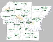
Townships in Arkansas are the divisions of a county. Each township includes unincorporated areas; some may have incorporated cities or towns within part of their boundaries. Arkansas townships have limited purposes in modern times. However, the United States Census does list Arkansas population based on townships (sometimes referred to as "county subdivisions" or "minor civil divisions"). Townships are also of value for historical purposes in terms of genealogical research. Each town or city is within one or more townships in an Arkansas county based on census maps and publications. The townships of Independence County are listed below; listed in parentheses are the cities, towns, and/or census-designated places that are fully or partially inside the township. [13][14]
- Ashley
- Barren (contains part of Cave City)
- Big Bottom-Wycough-Logan Township (contains Newark)
- Black River-Marshell
- Cushman-Union (contains Cushman)
- Departee
- Dota
- Fairview (contains Pleasant Plains)
- Gainsboro
- Greenbrier
- Hill
- Huff
- Jefferson
- Liberty
- McHue (contains part of Batesville)
- Magness (contains Magness)
- Moorefield (contains Moorefield, part of Batesville)
- Oil Trough (contains Oil Trough)
- Relief
- Rosie
- Ruddell (contains most of Batesville)
- Salado
- Washington
- White River (contains Sulphur Rock)
Source:[15]
See also
- List of lakes in Independence County, Arkansas
- James Sturch, state representative for Independence County
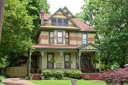
- National Register of Historic Places listings in Independence County, Arkansas
References
- "State & County QuickFacts". United States Census Bureau. Archived from the original on June 7, 2011. Retrieved May 21, 2014.
- "Find a County". National Association of Counties. Archived from the original on May 31, 2011. Retrieved 2011-06-07.
- Gannett, Henry (1905). The Origin of Certain Place Names in the United States. Govt. Print. Off. pp. 165.
- "2010 Census Gazetteer Files". United States Census Bureau. August 22, 2012. Retrieved August 26, 2015.
- "Population and Housing Unit Estimates". Retrieved September 28, 2019.
- "U.S. Decennial Census". United States Census Bureau. Retrieved August 26, 2015.
- "Historical Census Browser". University of Virginia Library. Retrieved August 26, 2015.
- Forstall, Richard L., ed. (March 27, 1995). "Population of Counties by Decennial Census: 1900 to 1990". United States Census Bureau. Retrieved August 26, 2015.
- "Census 2000 PHC-T-4. Ranking Tables for Counties: 1990 and 2000" (PDF). United States Census Bureau. April 2, 2001. Retrieved August 26, 2015.
- Based on 2000 census data
- "U.S. Census website". United States Census Bureau. Retrieved 2011-05-14.
- "Dave Leip's Atlas of U.S. Presidential Elections". Retrieved November 18, 2016.
- 2011 Boundary and Annexation Survey (BAS): Independence County, AR (PDF) (Map). U. S. Census Bureau. Archived from the original (PDF) on 2012-10-19. Retrieved 2011-08-10.
- "Arkansas: 2010 Census Block Maps - County Subdivision". United States Census Bureau. Archived from the original on May 28, 2014. Retrieved May 29, 2014.
-
"Summary Population and Housing Characteristics, CPH-1-5, Arkansas" (PDF). 2010 Census of Population and Housing. United States Census Bureau. September 2012. Retrieved May 31, 2014. External link in
|work=(help)
Places adjacent to Independence County, Arkansas | ||||||||||
|---|---|---|---|---|---|---|---|---|---|---|
| ||||||||||
Municipalities and communities of Independence County, Arkansas, United States | ||
|---|---|---|
| Cities | Map of Arkansas highlighting Independence County | |
| Towns | ||
| Unincorporated communities | ||
| Footnotes | ‡This populated place also has portions in an adjacent county or counties | |

| Authority control |
|
|---|