Dallas County, Arkansas
Dallas County is a county located in the U.S. state of Arkansas. As of the 2010 census, the population was 8,116,[1] making it the fourth-least populous county in Arkansas. The county seat is Fordyce.[2] Dallas County is Arkansas's 49th county, formed on January 1, 1845, and named for George M. Dallas, Vice President of the United States.
Dallas County | |
|---|---|
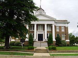 Courthouse in Fordyce | |
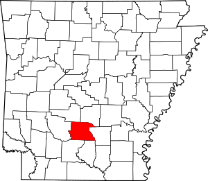 Location within the U.S. state of Arkansas | |
 Arkansas's location within the U.S. | |
| Coordinates: 33°58′37″N 92°40′23″W | |
| Country | |
| State | |
| Founded | January 1, 1845 |
| Named for | George M. Dallas |
| Seat | Fordyce |
| Largest city | Fordyce |
| Area | |
| • Total | 668 sq mi (1,730 km2) |
| • Land | 667 sq mi (1,730 km2) |
| • Water | 0.7 sq mi (2 km2) 0.1%% |
| Population (2010) | |
| • Total | 8,116 |
| • Estimate (2019) | 7,009 |
| • Density | 12/sq mi (4.7/km2) |
| Time zone | UTC−6 (Central) |
| • Summer (DST) | UTC−5 (CDT) |
| Congressional district | 4th |
Geography
According to the U.S. Census Bureau, the county has a total area of 668 square miles (1,730 km2), of which 667 square miles (1,730 km2) is land and 0.7 square miles (1.8 km2) (0.1%) is water.[3]
Major highways


Adjacent counties
- Grant County (northeast)
- Cleveland County (east)
- Calhoun County (southeast)
- Ouachita County (southwest)
- Clark County (west)
- Hot Spring County (northwest)
Demographics
| Historical population | |||
|---|---|---|---|
| Census | Pop. | %± | |
| 1850 | 6,877 | — | |
| 1860 | 8,283 | 20.4% | |
| 1870 | 5,707 | −31.1% | |
| 1880 | 6,505 | 14.0% | |
| 1890 | 9,296 | 42.9% | |
| 1900 | 11,518 | 23.9% | |
| 1910 | 12,621 | 9.6% | |
| 1920 | 14,424 | 14.3% | |
| 1930 | 14,671 | 1.7% | |
| 1940 | 14,471 | −1.4% | |
| 1950 | 12,416 | −14.2% | |
| 1960 | 10,522 | −15.3% | |
| 1970 | 10,022 | −4.8% | |
| 1980 | 10,515 | 4.9% | |
| 1990 | 9,614 | −8.6% | |
| 2000 | 9,210 | −4.2% | |
| 2010 | 8,116 | −11.9% | |
| Est. 2019 | 7,009 | [4] | −13.6% |
| U.S. Decennial Census[5] 1790–1960[6] 1900–1990[7] 1990–2000[8] 2010–2016[1] | |||
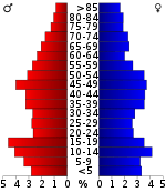
As of the 2000 census,[10] there were 9,210 people, 3,519 households, and 2,431 families residing in the county. The population density was 14 people per square mile (5/km²). There were 4,401 housing units at an average density of 7 per square mile (3/km²). The racial makeup of the county was 56.96% White, 40.98% Black or African American, 0.24% Native American, 0.23% Asian, 1.01% from other races, and 0.59% from two or more races. 1.92% of the population were Hispanic or Latino of any race.
There were 3,519 households out of which 29.60% had children under the age of 18 living with them, 51.00% were married couples living together, 13.80% had a female householder with no husband present, and 30.90% were non-families. 28.30% of all households were made up of individuals and 13.90% had someone living alone who was 65 years of age or older. The average household size was 2.48 and the average family size was 3.03.
In the county, the population was spread out with 26.20% under the age of 18, 8.30% from 18 to 24, 24.50% from 25 to 44, 24.10% from 45 to 64, and 17.00% who were 65 years of age or older. The median age was 38 years. For every 100 females there were 94.30 males. For every 100 females age 18 and over, there were 91.90 males.
The median income for a household in the county was $26,608, and the median income for a family was $32,630. Males had a median income of $28,538 versus $17,884 for females. The per capita income for the county was $14,610. About 13.30% of families and 18.90% of the population were below the poverty line, including 23.80% of those under age 18 and 20.00% of those age 65 or over.
Government
Over The past few election cycles Dallas county has trended heavily towards the GOP. The last democrat (as of 2016) to carry this county was Al Gore in 2000.
| Year | GOP | Dem | Others |
|---|---|---|---|
| 2016 | 54.46% 1,509 | 42.04% 1,165 | 3.50% 97 |
| 2012 | 53.99% 1,665 | 43.35% 1,337 | 2.66% 82 |
| 2008 | 52.95% 1,757 | 44.33% 1,471 | 2.71% 90 |
| 2004 | 50.18% 1,700 | 49.32% 1,671 | 0.50% 17 |
| 2000 | 47.25% 1,571 | 51.43% 1,710 | 1.32% 44 |
| 1996 | 30.31% 1,041 | 61.66% 2,118 | 8.03% 276 |
| 1992 | 37.15% 1,458 | 53.68% 2,107 | 9.17% 360 |
| 1988 | 49.19% 1,947 | 50.28% 1,990 | 0.53% 21 |
| 1984 | 52.80% 2,361 | 45.51% 2,035 | 1.70% 76 |
| 1980 | 35.16% 1,596 | 62.52% 2,838 | 2.31% 105 |
| 1976 | 23.61% 1,012 | 76.20% 3,266 | 0.19% 8 |
| 1972 | 60.55% 2,152 | 39.45% 1,402 | 0.00% 0 |
| 1968 | 18.43% 672 | 34.36% 1,253 | 47.22% 1,722 |
| 1964 | 47.14% 1,625 | 51.61% 1,779 | 1.25% 43 |
| 1960 | 25.20% 659 | 62.68% 1,639 | 12.12% 317 |
| 1956 | 35.63% 984 | 62.49% 1,726 | 1.88% 52 |
| 1952 | 25.03% 737 | 74.80% 2,202 | 0.17% 5 |
| 1948 | 8.93% 152 | 68.98% 1,174 | 22.09% 376 |
| 1944 | 17.65% 266 | 82.15% 1,238 | 0.20% 3 |
| 1940 | 8.04% 118 | 88.28% 1,295 | 3.68% 54 |
| 1936 | 6.71% 103 | 93.29% 1,433 | 0.00% 0 |
| 1932 | 6.53% 150 | 93.16% 2,139 | 0.30% 7 |
| 1928 | 32.73% 503 | 67.01% 1,030 | 0.26% 4 |
| 1924 | 26.68% 401 | 71.06% 1,068 | 2.26% 34 |
| 1920 | 36.19% 659 | 62.60% 1,140 | 1.21% 22 |
| 1916 | 31.43% 527 | 68.57% 1,150 | 0.00% 0 |
| 1912 | 17.33% 228 | 49.70% 654 | 32.98% 434 |
| 1908 | 44.26% 636 | 50.17% 721 | 5.57% 80 |
| 1904 | 43.06% 496 | 52.43% 604 | 4.51% 52 |
| 1900 | 40.35% 514 | 58.56% 746 | 1.10% 14 |
| 1896 | 31.55% 479 | 67.98% 1,032 | 0.46% 7 |
Communities
Townships
Townships in Arkansas are the divisions of a county. Each township includes unincorporated areas; some may have incorporated cities or towns within part of their boundaries. Arkansas townships have limited purposes in modern times. However, the United States Census does list Arkansas population based on townships (sometimes referred to as "county subdivisions" or "minor civil divisions"). Townships are also of value for historical purposes in terms of genealogical research. Each town or city is within one or more townships in an Arkansas county based on census maps and publications. The townships of Dallas County are listed below; listed in parentheses are the cities, towns, and/or census-designated places that are fully or partially inside the township. [12][13]
Notable people
Mollie Burdett Banks Curry Gray (1862-1958), a native of Tulip in Dallas County, was a great-great-grand-niece of George Washington. When she died in 1958 in Shreveport, Louisiana, she was listed as the oldest descendant of President Washington. Mollie's first husband, Robert Houston Curry, was from 1888 to 1892 a member of the Louisiana House of Representatives from Bossier Parish. He was wounded in the Second Battle of Manassas of the American Civil War.[14][15]
References
- "State & County QuickFacts". United States Census Bureau. Archived from the original on June 7, 2011. Retrieved May 20, 2014.
- "Find a County". National Association of Counties. Archived from the original on May 31, 2011. Retrieved 2011-06-07.
- "2010 Census Gazetteer Files". United States Census Bureau. August 22, 2012. Retrieved August 26, 2015.
- "Population and Housing Unit Estimates". Retrieved September 28, 2019.
- "U.S. Decennial Census". United States Census Bureau. Retrieved August 26, 2015.
- "Historical Census Browser". University of Virginia Library. Retrieved August 26, 2015.
- Forstall, Richard L., ed. (March 27, 1995). "Population of Counties by Decennial Census: 1900 to 1990". United States Census Bureau. Retrieved August 26, 2015.
- "Census 2000 PHC-T-4. Ranking Tables for Counties: 1990 and 2000" (PDF). United States Census Bureau. April 2, 2001. Retrieved August 26, 2015.
- Based on 2000 census data
- "U.S. Census website". United States Census Bureau. Retrieved 2011-05-14.
- "Dave Leip's Atlas of U.S. Presidential Elections". Retrieved November 18, 2016.
- 2011 Boundary and Annexation Survey (BAS): Dallas County, AR (PDF) (Map). U. S. Census Bureau. Archived from the original (PDF) on 2012-10-19. Retrieved 2011-08-23.
- "Arkansas: 2010 Census Block Maps - County Subdivision". United States Census Bureau. Retrieved May 28, 2014.
- "Oldest Descendant Of First President Succumbs At 93". The Monroe News-Star. Monroe, Louisiana. May 19, 1958. p. 7. Retrieved July 24, 2015.
- "Curry, Robert H." The Political Graveyard. Retrieved July 24, 2015.
Places adjacent to Dallas County, Arkansas | ||||||||||
|---|---|---|---|---|---|---|---|---|---|---|
| ||||||||||
Municipalities and communities of Dallas County, Arkansas, United States | ||
|---|---|---|
| Cities | Map of Arkansas highlighting Dallas County | |
| Unincorporated communities | ||

| Authority control |
|
|---|