Faulkner County, Arkansas
Faulkner County is a county located in the Central Arkansas region of the U.S. state of Arkansas. As of the 2010 census, the population was 113,237, making it the fifth most populous of Arkansas's seventy-five counties.[1] The county seat and largest city is Conway.[2] Faulkner County was created on April 12, 1873, one of nine counties formed during Reconstruction, and is named for Arkansas Militia Colonel Sandy Faulkner, a popular figure in the state at the time.
Faulkner County | |
|---|---|
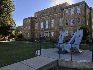 Faulkner County Courthouse | |
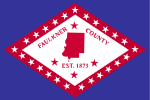 Flag  Seal | |
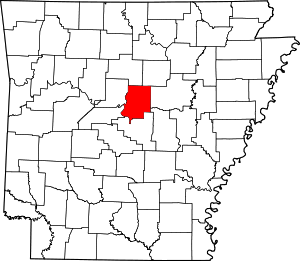 Location within the U.S. state of Arkansas | |
 Arkansas's location within the U.S. | |
| Coordinates: 35°09′36″N 92°18′49″W | |
| Country | |
| State | |
| Founded | April 12, 1873 |
| Named for | Sanford Faulkner |
| Seat | Conway |
| Largest city | Conway |
| Area | |
| • Total | 664 sq mi (1,720 km2) |
| • Land | 648 sq mi (1,680 km2) |
| • Water | 16 sq mi (40 km2) 2.4%% |
| Population (2010) | |
| • Total | 113,237 |
| • Estimate (2019) | 126,007 |
| • Density | 170/sq mi (66/km2) |
| Time zone | UTC−6 (Central) |
| • Summer (DST) | UTC−5 (CDT) |
| Congressional district | 2nd |
| Website | www |
Located at the intersection of the Ozarks and Arkansas River Valley, the county was sparsely populated for much of its early years. Largely a county of rural settlements, growth came slowly following the Civil War and Reconstruction. The college known today as University of Central Arkansas was established in 1907, but population continued to grow slowly. The growth of Little Rock and the construction of Interstate 40 have made Conway and other parts of Faulkner County into bedroom communities for the state capitol. Today Faulkner County is included in the Central Arkansas metro area, with Conway as a principal city.
History
Eponym
Faulkner County was formed from parts of Conway and Pulaski counties on April 12, 1873, and is named after Colonel Sanford C. 'Sandy' Faulkner[3] who was the composer of the popular fiddle tune "The Arkansas Traveler".
Geography
According to the U.S. Census Bureau, the county has a total area of 664 square miles (1,720 km2), of which 648 square miles (1,680 km2) is land and 16 square miles (41 km2) (2.4%) is water.[4]
Major highways
.svg.png)


Adjacent counties
- Cleburne County (northeast)
- White County (east)
- Lonoke County (southeast)
- Pulaski County (south)
- Perry County (southwest)
- Conway County (west)
- Van Buren County (northwest)
Demographics
| Historical population | |||
|---|---|---|---|
| Census | Pop. | %± | |
| 1880 | 12,786 | — | |
| 1890 | 18,342 | 43.5% | |
| 1900 | 20,780 | 13.3% | |
| 1910 | 23,708 | 14.1% | |
| 1920 | 27,681 | 16.8% | |
| 1930 | 28,381 | 2.5% | |
| 1940 | 25,880 | −8.8% | |
| 1950 | 25,289 | −2.3% | |
| 1960 | 24,303 | −3.9% | |
| 1970 | 31,572 | 29.9% | |
| 1980 | 46,192 | 46.3% | |
| 1990 | 60,006 | 29.9% | |
| 2000 | 86,014 | 43.3% | |
| 2010 | 113,237 | 31.6% | |
| Est. 2019 | 126,007 | [5] | 11.3% |
| U.S. Decennial Census[6] 1790–1960[7] 1900–1990[8] 1990–2000[9] 2010–2016[1] | |||
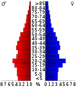
As of the 2000 United States Census,[11] there were 86,014 people, 31,882 households, and 22,444 families residing in the county. The population density was 133 people per square mile (51/km²). There were 34,546 housing units at an average density of 53 per square mile (21/km²). The racial makeup of the county was 88.33% White, 8.48% Black or African American, 0.52% Native American, 0.72% Asian, 0.03% Pacific Islander, 0.68% from other races, and 1.23% from two or more races. 1.75% of the population were Hispanic or Latino of any race.
There were 31,882 households out of which 35.70% had children under the age of 18 living with them, 56.70% were married couples living together, 10.20% had a female householder with no husband present, and 29.60% were non-families. 22.50% of all households were made up of individuals and 6.90% had someone living alone who was 65 years of age or older. The average household size was 2.57 and the average family size was 3.04.
In the county, the population was spread out with 25.60% under the age of 18, 15.30% from 18 to 24, 30.10% from 25 to 44, 19.50% from 45 to 64, and 9.50% who were 65 years of age or older. The median age was 31 years. For every 100 females, there were 95.50 males. For every 100 females age 18 and over, there were 92.30 males.
The median income for a household in the county was $38,204, and the median income for a family was $45,946. Males had a median income of $32,288 versus $24,428 for females. The per capita income for the county was $35,159.[12] About 7.90% of families and 12.50% of the population were below the poverty line, including 12.90% of those under age 18 and 12.00% of those age 65 or over.
Government
Over The past few election cycles Faulkner county has trended heavily towards the GOP. The last democrat (as of 2016) to carry this county was Bill Clinton in 1996.
| Year | GOP | DEM | Others |
|---|---|---|---|
| 2016 | 61.75% 29,346 | 30.78% 14,629 | 7.47% 3,552 |
| 2012 | 64.45% 26,722 | 32.85% 13,621 | 2.69% 1,117 |
| 2008 | 61.59% 25,362 | 36.32% 14,955 | 2.09% 862 |
| 2004 | 58.64% 21,514 | 39.63% 14,538 | 1.73% 634 |
| 2000 | 54.95% 16,055 | 40.90% 11,950 | 4.15% 1,211 |
| 1996 | 42.19% 10,178 | 49.88% 12,032 | 7.93% 1,913 |
| 1992 | 37.64% 9,491 | 51.56% 13,000 | 10.80% 2,724 |
| 1988 | 58.42% 10,678 | 39.95% 7,302 | 1.64% 299 |
| 1984 | 60.89% 11,595 | 37.65% 7,169 | 1.47% 279 |
| 1980 | 44.19% 7,544 | 49.95% 8,528 | 5.86% 1,001 |
| 1976 | 25.44% 3,904 | 74.45% 11,423 | 0.10% 16 |
| 1972 | 59.44% 6,746 | 40.56% 4,604 | 0.00% 0 |
| 1968 | 25.55% 2,791 | 34.39% 3,756 | 40.06% 4,375 |
| 1964 | 34.61% 3,259 | 64.95% 6,116 | 0.45% 42 |
| 1960 | 36.71% 2,426 | 57.80% 3,820 | 5.49% 363 |
| 1956 | 40.94% 2,399 | 58.50% 3,428 | 0.56% 33 |
| 1952 | 36.47% 1,995 | 63.27% 3,461 | 0.26% 14 |
| 1948 | 17.40% 626 | 73.76% 2,653 | 8.84% 318 |
| 1944 | 27.69% 897 | 72.00% 2,332 | 0.31% 10 |
| 1940 | 16.93% 519 | 82.68% 2,535 | 0.39% 12 |
| 1936 | 16.79% 511 | 82.82% 2,521 | 0.39% 12 |
| 1932 | 13.48% 437 | 84.77% 2,749 | 1.76% 57 |
| 1928 | 27.07% 992 | 72.57% 2,659 | 0.35% 13 |
| 1924 | 25.14% 536 | 67.35% 1,436 | 7.50% 160 |
| 1920 | 35.31% 1,148 | 60.63% 1,971 | 4.06% 132 |
| 1916 | 28.69% 817 | 71.31% 2,031 | 0.00% 0 |
| 1912 | 20.20% 402 | 66.13% 1,316 | 13.67% 272 |
| 1908 | 28.00% 740 | 67.01% 1,771 | 4.99% 132 |
| 1904 | 40.06% 764 | 56.27% 1,073 | 3.67% 70 |
| 1900 | 35.69% 682 | 62.32% 1,191 | 1.99% 38 |
| 1896 | 21.27% 556 | 78.19% 2,044 | 0.54% 14 |
Education
Public education
Publicly funded education for elementary and secondary school students is provided by:
- Conway School District, which includes Conway High School, Conway
- Greenbrier School District, which includes Greenbrier High School, Greenbrier
- Guy–Perkins School District, which includes Guy–Perkins High School, Guy
- Mayflower School District, which includes Mayflower High School, Mayflower
- Mount Vernon–Enola School District, which includes Mount Vernon–Enola High School, Mount Vernon
- Vilonia School District, which includes Vilonia High School, Vilonia
Private education
Privately funded education for elementary and secondary school students is provided by:
- St. Joseph High School, Conway
- Conway Christian School (Conway, Arkansas)
Communities
Towns
- Damascus (partly in Van Buren County)
- Enola
- Mount Vernon
- Twin Groves
- Wooster
Townships
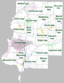
Townships in Arkansas are the divisions of a county. Each township includes unincorporated areas; some may have incorporated cities or towns within part of their boundaries. Arkansas townships have limited purposes in modern times. However, the United States Census does list Arkansas population based on townships (sometimes referred to as "county subdivisions" or "minor civil divisions"). Townships are also of value for historical purposes in terms of genealogical research. Each town or city is within one or more townships in an Arkansas county based on census maps and publications. The townships of Faulkner County are listed below; listed in parentheses are the cities, towns, and/or census-designated places that are fully or partially inside the township. [14][15]
- Beaverfork
- Benedict (contains part of Conway)
- Benton (contains part of Quitman)
- Bristol
- Cadron (contains most of Conway and part of Mayflower)
- California (contains most of Guy, part of Twin Groves)
- Clifton (contains Wooster)
- Cypress (contains most of Vilonia)
- Danley (contains most of Mayflower)
- Eagle (contains part of Holland and Vilonia)
- East Fork
- Enola (contains most of Enola)
- Hardin (contains Greenbrier and part of Holland)
- Harve (contains most of Holland, part of Enola)
- Liberty
- Matthews
- Mountain
- Mount Vernon (contains Mount Vernon)
- Newton
- Palarm (contains part of Vilonia)
- Pine Mountain (contains part of Conway and Mayflower)
- Union (contains part of Twin Groves)
- Walker (contains most of Twin Groves, part of Damascus and Guy)
- Wilson
Source:[16]
See also
- Faulconer County
- List of lakes in Faulkner County, Arkansas
- National Register of Historic Places listings in Faulkner County, Arkansas
- David J. Sanders, state senator who represents part of Faulkner County
- David Meeks and Stephen Meeks, Republican brothers from Faulkner County who represent Districts 70 and 67, respectively in the Arkansas House of Representatives
References
- "State & County QuickFacts". United States Census Bureau. Archived from the original on June 7, 2011. Retrieved May 20, 2014.
- "Find a County". National Association of Counties. Archived from the original on 2011-05-31. Retrieved 2011-06-07.
- Gannett, Henry (1905). The Origin of Certain Place Names in the United States. Govt. Print. Off. p. 124.
- "2010 Census Gazetteer Files". United States Census Bureau. August 22, 2012. Retrieved August 26, 2015.
- "Population and Housing Unit Estimates". Retrieved September 28, 2019.
- "U.S. Decennial Census". United States Census Bureau. Retrieved August 26, 2015.
- "Historical Census Browser". University of Virginia Library. Retrieved August 26, 2015.
- Forstall, Richard L., ed. (March 27, 1995). "Population of Counties by Decennial Census: 1900 to 1990". United States Census Bureau. Retrieved August 26, 2015.
- "Census 2000 PHC-T-4. Ranking Tables for Counties: 1990 and 2000" (PDF). United States Census Bureau. April 2, 2001. Retrieved August 26, 2015.
- Based on 2000 census data
- "U.S. Census website". United States Census Bureau. Retrieved 2011-05-14.
- "Local Area Personal Incomes". Bureau of Economic Analysis. Bureau of Economic Analysis. Retrieved 6 February 2018.
- "Dave Leip's Atlas of U.S. Presidential Elections". Retrieved November 18, 2016.
- 2011 Boundary and Annexation Survey (BAS): Faulkner County, AR (PDF) (Map). U. S. Census Bureau. Archived from the original (PDF) on 2012-10-19. Retrieved 2011-08-04.
- "Arkansas: 2010 Census Block Maps - County Subdivision". United States Census Bureau. Retrieved May 28, 2014.
- "Summary Population and Housing Characteristics, CPH-1-5, Arkansas" (PDF). 2010 Census of Population and Housing. United States Census Bureau. September 2012. Retrieved May 31, 2014.
External links
- 10th Arkansas Infantry, Local Regiment During the Civil War
- Independent Living Services provides support for over 200 people with developmental disabilities in central Arkansas.
- Arkansas Shakespeare Theatre, based in Conway, is the state's only professional Shakespeare company.
Places adjacent to Faulkner County, Arkansas | ||||||||||
|---|---|---|---|---|---|---|---|---|---|---|
| ||||||||||
Municipalities and communities of Faulkner County, Arkansas, United States | ||
|---|---|---|
| Cities | Map of Arkansas highlighting Faulkner County | |
| Towns | ||
| Unincorporated communities | ||
| Footnotes | ‡This populated place also has portions in an adjacent county or counties | |

| Authority control |
|
|---|