Marion County, Arkansas
Marion County is located in the Ozark Mountains in the U.S. state of Arkansas. The county is named for Francis Marion, the famous "Swamp Fox" of the Revolutionary War. Created as Arkansas's 35th county in 1836, Marion County is home to one incorporated town and four incorporated cities, including Yellville, the county seat. The county is also the site of numerous unincorporated communities and ghost towns. The county included part of what is now Searcy County, Arkansas, with many opposing to dividing them, which helped fueled the bloody Tutt-Everett War between 1844 and 1850.
Marion County | |
|---|---|
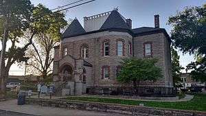 Marion County courthouse in Yellville | |
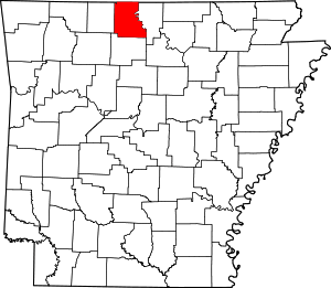 Location within the U.S. state of Arkansas | |
 Arkansas's location within the U.S. | |
| Coordinates: 36°16′47″N 92°42′57″W | |
| Country | |
| State | |
| Founded | September 25, 1836 |
| Named for | Francis Marion[1] |
| Seat | Yellville |
| Largest city | Bull Shoals |
| Area | |
| • Total | 640 sq mi (1,700 km2) |
| • Land | 597 sq mi (1,550 km2) |
| • Water | 43 sq mi (110 km2) 6.8%% |
| Population (2010) | |
| • Total | 16,653 |
| • Estimate (2019) | 16,694 |
| • Density | 26/sq mi (10/km2) |
| Time zone | UTC−6 (Central) |
| • Summer (DST) | UTC−5 (CDT) |
| Congressional district | 3rd |
| Website | marioncounty |
Occupying 640 square miles (170,000 ha), Marion County is the 33rd smallest county in Arkansas. As of the 2010 Census, the county's population is 16,653 people in 3,531 households.[2] Based on population, the county is the twenty-seventh smallest county of the 75 in Arkansas.[3] Located in the Ozarks, the county is largely covered with rugged terrain and waterways, with the exception of King's Prairie in the southwestern portion. It is drained by the White River, Buffalo River, Crooked Creek, and the Little North Fork of White River. Protected areas of the county include Bull Shoals-White River State Park, Ozark National Forest, the Buffalo National River and four wildlife management areas (WMAs).
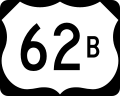
Although no Interstate highways are located in Marion County, two United States highways (U.S. Route 62 [US 62] and US 412) and eight Arkansas state highways run in the county.[4]
History
Prior to white settlement, the Ozark Plateau was inhabited by the Osage Indians for centuries.[5] Present-day Arkansas was under French rule from 1682 until the Spanish took over in 1762. The territory was returned to France in 1800 and then sold to the United States as part of the Louisiana Purchase in 1803. In 1812, the Territory of Missouri was formed, containing all of the Louisiana Purchase except the modern state of Louisiana. To manage this expansive and sparsely populated territory, counties were formed. New Madrid County, Missouri covered much of southeastern Missouri and the northern part of Arkansas. This county was eventually subdivided into Lawrence County, which was later subdivided into Izard County.[6]
Marion County was formerly home to a large zinc mining industry. The ruins of the Rush Creek mining district are preserved as the Rush Historic District, which is listed on the National Register of Historic Places.
Geography
According to the U.S. Census Bureau, the county has a total area of 640 square miles (1,700 km2), of which 597 square miles (1,550 km2) is land and 43 square miles (110 km2) (6.8%) is water.[7]
Adjacent counties
- Ozark County, Missouri (north)
- Baxter County (east)
- Searcy County (south)
- Boone County (west)
- Taney County, Missouri (northwest)
National protected areas
- Buffalo National River (part)
- Buffalo National River Wilderness
- Ozark National Forest (part)
Demographics
| Historical population | |||
|---|---|---|---|
| Census | Pop. | %± | |
| 1840 | 1,325 | — | |
| 1850 | 2,308 | 74.2% | |
| 1860 | 6,192 | 168.3% | |
| 1870 | 3,979 | −35.7% | |
| 1880 | 7,907 | 98.7% | |
| 1890 | 10,390 | 31.4% | |
| 1900 | 11,377 | 9.5% | |
| 1910 | 10,203 | −10.3% | |
| 1920 | 10,154 | −0.5% | |
| 1930 | 8,876 | −12.6% | |
| 1940 | 9,464 | 6.6% | |
| 1950 | 8,609 | −9.0% | |
| 1960 | 6,041 | −29.8% | |
| 1970 | 7,000 | 15.9% | |
| 1980 | 11,334 | 61.9% | |
| 1990 | 12,001 | 5.9% | |
| 2000 | 16,140 | 34.5% | |
| 2010 | 16,653 | 3.2% | |
| Est. 2019 | 16,694 | [8] | 0.2% |
| U.S. Decennial Census[9] 1790–1960[10] 1900–1990[11] 1990–2000[12] 2010–2016[2] | |||
As of the 2000 census,[14] there were 16,140 people, 6,776 households, and 4,871 families residing in the county. The population density was 27 people per square mile (10/km²). There were 8,235 housing units at an average density of 14 per square mile (5/km²). The racial makeup of the county was 97.52% White, 0.12% Black or African American, 0.76% Native American, 0.20% Asian, 0.05% Pacific Islander, 0.13% from other races, and 1.22% from two or more races. 0.76% of the population were Hispanic or Latino of any race.
There were 6,776 households out of which 26.00% had children under the age of 18 living with them, 61.30% were married couples living together, 7.40% had a female householder with no husband present, and 28.10% were non-families. 24.90% of all households were made up of individuals and 12.40% had someone living alone who was 65 years of age or older. The average household size was 2.36 and the average family size was 2.79.
In the county, the population was spread out with 22.10% under the age of 18, 6.00% from 18 to 24, 23.30% from 25 to 44, 28.50% from 45 to 64, and 20.00% who were 65 years of age or older. The median age was 44 years. For every 100 females there were 97.90 males. For every 100 females age 18 and over, there were 94.80 males. The median income for a household in the county was $26,737, and the median income for a family was $32,181. Males had a median income of $22,877 versus $17,729 for females. The per capita income for the county was $14,588. About 11.50% of families and 15.20% of the population were below the poverty line, including 23.50% of those under age 18 and 14.40% of those age 65 or over.
Government
The county government is a constitutional body granted specific powers by the Constitution of Arkansas and the Arkansas Code. The quorum court is the legislative branch of the county government and controls all spending and revenue collection. Representatives are called justices of the peace and are elected from county districts every even-numbered year. The number of districts in a county vary from nine to fifteen, and district boundaries are drawn by the county election commission. The Marion County Quorum Court has nine members. Presiding over quorum court meetings is the county judge, who serves as the chief operating officer of the county. The county judge is elected at-large and does not vote in quorum court business, although capable of vetoing quorum court decisions.[15][16]
Politics
Over The past few election cycles Marion County has trended heavily towards the GOP. The last democrat (as of 2016) to carry this county was Bill Clinton in 1996.
| Year | GOP | Dem | Others |
|---|---|---|---|
| 2016 | 75.08% 5,336 | 20.18% 1,434 | 4.74% 337 |
| 2012 | 67.71% 4,774 | 28.89% 2,037 | 3.40% 240 |
| 2008 | 63.17% 4,524 | 33.29% 2,384 | 3.55% 254 |
| 2004 | 60.10% 4,127 | 37.89% 2,602 | 2.01% 138 |
| 2000 | 56.56% 3,402 | 37.12% 2,233 | 6.32% 380 |
| 1996 | 37.75% 2,312 | 44.65% 2,735 | 17.60% 1,078 |
| 1992 | 32.39% 2,023 | 44.15% 2,757 | 23.46% 1,465 |
| 1988 | 57.80% 2,993 | 39.26% 2,033 | 2.94% 152 |
| 1984 | 64.17% 3,545 | 35.21% 1,945 | 0.62% 34 |
| 1980 | 57.11% 3,059 | 38.20% 2,046 | 4.69% 251 |
| 1976 | 40.70% 2,045 | 59.30% 2,979 | |
| 1972 | 66.66% 2,331 | 31.68% 1,108 | 1.66% 58 |
| 1968 | 42.59% 1,385 | 30.44% 990 | 26.97% 877 |
| 1964 | 39.43% 1,088 | 60.20% 1,661 | 0.36% 10 |
| 1960 | 50.60% 1,016 | 48.21% 968 | 1.20% 24 |
| 1956 | 44.59% 857 | 55.20% 1,061 | 0.21% 4 |
| 1952 | 43.06% 844 | 56.07% 1,099 | 0.87% 17 |
| 1948 | 24.41% 381 | 72.58% 1,133 | 3.01% 47 |
| 1944 | 32.65% 414 | 66.40% 842 | 0.95% 12 |
| 1940 | 26.64% 320 | 71.94% 864 | 1.42% 17 |
| 1936 | 30.21% 435 | 68.68% 989 | 1.11% 16 |
| 1932 | 14.70% 235 | 80.18% 1,282 | 5.13% 82 |
| 1928 | 37.17% 436 | 62.32% 731 | 0.51% 6 |
| 1924 | 21.56% 282 | 63.07% 825 | 15.37% 201 |
| 1920 | 28.60% 371 | 57.36% 744 | 14.03% 182 |
| 1916 | 25.97% 274 | 74.03% 781 | 0.00% 0 |
| 1912 | 16.02% 160 | 53.75% 537 | 30.23% 302 |
| 1908 | 31.92% 370 | 60.83% 705 | 7.25% 84 |
| 1904 | 37.39% 356 | 60.92% 580 | 1.68% 16 |
| 1900 | 29.16% 375 | 70.37% 905 | 0.47% 6 |
| 1896 | 21.32% 336 | 76.90% 1,212 | 1.78% 28 |
Taxation
Property tax is assessed by the Marion County Assessor annually based upon the fair market value of the property and determining which tax rate, commonly called a millage in Arkansas, will apply. The rate depends upon the property's location with respect to city limits, school district, and special tax increment financing (TIF) districts. This tax is collected by the Marion County Collector between the first business day of March of each year through October 15th without penalty. The Marion County Treasurer disburses tax revenues to various government agencies, such as cities, county road departments, fire departments, libraries, and police departments in accordance with the budget set by the quorum court.
Sales and use taxes in Arkansas are voter approved and collected by the Arkansas Department of Finance and Administration. Arkansas's statewide sales and use tax has been 6.5% since July 1, 2013.[18] Marion County has an additional sales and use tax of 1.75%, which has been in effect since April 1, 2017. Within Marion County, the five municipalities each also have additional sales and use tax: Bull Shoals and Yellville levy an additional 2%, Flippin and Summit 1%, and Pyatt 0.5%.[19] The Arkansas State Treasurer disburses state tax revenue to counties/cities in accordance with tax rules.
Communities
Cities
- Bull Shoals
- Flippin
- Summit
- Yellville (county seat)
Town
Townships
Note: Unlike most Arkansas counties, Marion County only has one single township (named "Marion County"). That township encompasses the entire county.
Townships in Arkansas are the divisions of a county. Each township includes unincorporated areas; some may have incorporated cities or towns within part of their boundaries. Arkansas townships have limited purposes in modern times. However, the United States Census does list Arkansas population based on townships (sometimes referred to as "county subdivisions" or "minor civil divisions"). Townships are also of value for historical purposes in terms of genealogical research. Each town or city is within one or more townships in an Arkansas county based on census maps and publications. The townships of Marion County are listed below; listed in parentheses are the cities, towns, and/or census-designated places that are fully or partially inside the township. [20][21]
- Marion County
Infrastructure
Major highways
.svg.png)


.svg.png)
See also
- List of lakes in Marion County, Arkansas
- National Register of Historic Places listings in Marion County, Arkansas
References
- Gannett, Henry (1905). The Origin of Certain Place Names in the United States. U.S. Government Printing Office. p. 200.
- "State & County QuickFacts". United States Census Bureau. Archived from the original on June 7, 2011. Retrieved May 23, 2014.
- "Find a County". National Association of Counties. Retrieved 2011-06-07.
- General Highway Map - Marion County, Arkansas (PDF) (Map) (2008-04-15 ed.). Arkansas State Highway and Transportation Department. Retrieved 2016-06-06.
- Berry, Earl, ed. (1977). History of Marion County. Yellville: Marion County Historical Association. p. 1. LCCN 77-73201. OCLC 53220751.CS1 maint: ref=harv (link)
- History (1977), p. 1.
- "2010 Census Gazetteer Files". United States Census Bureau. August 22, 2012. Retrieved August 27, 2015.
- "Population and Housing Unit Estimates". Retrieved September 28, 2019.
- "U.S. Decennial Census". United States Census Bureau. Retrieved August 27, 2015.
- "Historical Census Browser". University of Virginia Library. Retrieved August 27, 2015.
- Forstall, Richard L., ed. (March 27, 1995). "Population of Counties by Decennial Census: 1900 to 1990". United States Census Bureau. Retrieved August 27, 2015.
- "Census 2000 PHC-T-4. Ranking Tables for Counties: 1990 and 2000" (PDF). United States Census Bureau. April 2, 2001. Retrieved August 27, 2015.
- Based on 2000 census data
- "U.S. Census website". United States Census Bureau. Retrieved 2011-05-14.
- Teske, Steven (March 24, 2014). "Quorum Courts". Encyclopedia of Arkansas History and Culture. Butler Center for Arkansas Studies at the Central Arkansas Library System. Retrieved January 23, 2016.
- Goss, Kay C. (August 28, 2015). "Office of County Judge". Encyclopedia of Arkansas History and Culture. Butler Center for Arkansas Studies at the Central Arkansas Library System. Retrieved January 23, 2016.
- "Dave Leip's Atlas of U.S. Presidential Elections". Retrieved November 18, 2016.
- "State Tax Rates". Arkansas Department of Finance and Administration. Retrieved December 29, 2018.
- "List of Cities and Counties with Local Sales and Use Tax" (PDF). Arkansas Department of Finance and Administration. October–December 2018. Retrieved March 3, 2019.
- 2011 Boundary and Annexation Survey (BAS): Marion County, AR (PDF) (Map). U. S. Census Bureau. Archived from the original (PDF) on 2012-10-19. Retrieved 2011-08-23.
- "Arkansas: 2010 Census Block Maps - County Subdivision". United States Census Bureau. Retrieved May 29, 2014.
External links
Places adjacent to Marion County, Arkansas | ||||||||||
|---|---|---|---|---|---|---|---|---|---|---|
| ||||||||||
Municipalities and communities of Marion County, Arkansas, United States | ||
|---|---|---|
| Cities | Map of Arkansas highlighting Marion County | |
| Town | ||
| Unincorporated communities | ||

| Authority control |
|
|---|