Saline County, Arkansas
Saline County is a county located in the U.S. state of Arkansas. As of the 2010 census, the population was 107,118.[1] at the 2010 census. Its county seat and largest city is Benton.[2] Saline County was formed on November 2, 1835, and named for the salt water (brine) springs in the area, however, it is pronounced "suh-LEAN" instead of the typical pronunciation, "SAY-lean". Until November 2014, it was an alcohol prohibition or dry county.
Saline County | |
|---|---|
.jpg) Saline County Courthouse in Benton | |
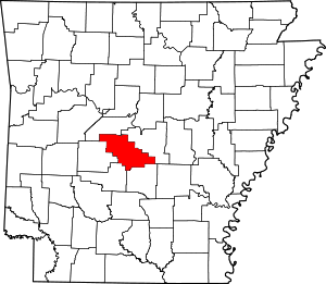 Location within the U.S. state of Arkansas | |
 Arkansas's location within the U.S. | |
| Coordinates: 34°39′04″N 92°40′54″W | |
| Country | |
| State | |
| Founded | November 2, 1835 |
| Seat | Benton |
| Largest city | Benton |
| Area | |
| • Total | 730 sq mi (1,900 km2) |
| • Land | 724 sq mi (1,880 km2) |
| • Water | 6.9 sq mi (18 km2) 0.9%% |
| Population (2010) | |
| • Total | 107,118 |
| • Estimate (2019) | 122,437 |
| • Density | 150/sq mi (57/km2) |
| Time zone | UTC−6 (Central) |
| • Summer (DST) | UTC−5 (CDT) |
| Congressional district | 2nd |
| Website | www |
Saline County is included in the Little Rock–North Little Rock–Conway, AR Metropolitan Statistical Area.
Geography
According to the U.S. Census Bureau, the county has a total area of 730 square miles (1,900 km2), of which 724 square miles (1,880 km2) is land and 6.9 square miles (18 km2) (0.9%) is water.[3]
Major highways
.svg.png)

.svg.png)


Adjacent counties
- Perry County (northwest)
- Pulaski County (northeast)
- Grant County (southeast)
- Hot Spring County (southwest)
- Garland County (west)
National protected area
- Ouachita National Forest (part)
Demographics
| Historical population | |||
|---|---|---|---|
| Census | Pop. | %± | |
| 1840 | 2,061 | — | |
| 1850 | 3,903 | 89.4% | |
| 1860 | 6,640 | 70.1% | |
| 1870 | 3,911 | −41.1% | |
| 1880 | 8,953 | 128.9% | |
| 1890 | 11,311 | 26.3% | |
| 1900 | 13,122 | 16.0% | |
| 1910 | 16,657 | 26.9% | |
| 1920 | 16,781 | 0.7% | |
| 1930 | 15,660 | −6.7% | |
| 1940 | 19,163 | 22.4% | |
| 1950 | 23,816 | 24.3% | |
| 1960 | 28,956 | 21.6% | |
| 1970 | 36,107 | 24.7% | |
| 1980 | 53,161 | 47.2% | |
| 1990 | 64,183 | 20.7% | |
| 2000 | 83,529 | 30.1% | |
| 2010 | 107,118 | 28.2% | |
| Est. 2019 | 122,437 | [4] | 14.3% |
| U.S. Decennial Census[5] 1790–1960[6] 1900–1990[7] 1990–2000[8] 2010–2016[1] | |||
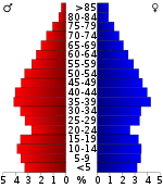
As of the 2000 United States Census,[10] there were 83,529 people, 31,778 households, and 24,500 families residing in the county. The population density was 116 people per square mile (45/km²). There were 33,825 housing units at an average density of 47 per square mile (18/km²). The racial makeup of the county was 95.27% White, 2.20% Black or African American, 0.49% Native American, 0.57% Asian, 0.03% Pacific Islander, 0.45% from other races, and 1.00% from two or more races. 1.30% of the population were Hispanic or Latino of any race.
There were 31,778 households out of which 35.40% had children under the age of 18 living with them, 63.80% were married couples living together, 9.70% had a female householder with no husband present, and 22.90% were non-families. 19.60% of all households were made up of individuals and 7.50% had someone living alone who was 65 years of age or older. The average household size was 2.57 and the average family size was 2.94.
In the county, the population was spread out with 25.50% under the age of 18, 7.70% from 18 to 24, 30.20% from 25 to 44, 24.20% from 45 to 64, and 12.50% who were 65 years of age or older. The median age was 37 years. For every 100 females, there were 98.10 males. For every 100 females age 18 and over, there were 95.30 males.
The median income for a household in the county was $42,569, and the median income for a family was $48,717. Males had a median income of $32,052 versus $23,294 for females. The per capita income for the county was $19,214. About 5.00% of families and 7.20% of the population were below the poverty line, including 8.80% of those under age 18 and 7.30% of those age 65 or over.
Media
The area is served online and in print by The Saline Courier.[11]
Government
Over The past few election cycles Saline County has trended heavily towards the GOP. The last democrat (as of 2016) to carry this county was Bill Clinton in 1996.
| Year | GOP | DEM | Others |
|---|---|---|---|
| 2016 | 68.83% 35,863 | 25.44% 13,256 | 5.73% 2,981 |
| 2012 | 70.04% 32,963 | 27.34% 12,869 | 2.61% 1,230 |
| 2008 | 69.38% 30,981 | 28.43% 12,695 | 2.19% 977 |
| 2004 | 63.15% 24,864 | 35.94% 14,153 | 0.91% 359 |
| 2000 | 57.48% 18,617 | 39.21% 12,700 | 3.32% 1,074 |
| 1996 | 40.77% 11,695 | 48.90% 14,027 | 10.33% 2,963 |
| 1992 | 39.38% 10,105 | 49.38% 12,671 | 11.24% 2,885 |
| 1988 | 58.89% 12,353 | 40.22% 8,436 | 0.90% 188 |
| 1984 | 60.68% 11,709 | 36.16% 6,977 | 3.17% 611 |
| 1980 | 42.60% 8,330 | 53.02% 10,368 | 4.38% 857 |
| 1976 | 25.55% 4,123 | 74.41% 12,008 | 0.04% 7 |
| 1972 | 63.64% 7,972 | 35.95% 4,503 | 0.42% 52 |
| 1968 | 23.15% 2,614 | 27.55% 3,111 | 49.31% 5,569 |
| 1964 | 38.96% 3,628 | 60.18% 5,605 | 0.86% 80 |
| 1960 | 32.32% 2,195 | 57.40% 3,898 | 10.28% 698 |
| 1956 | 40.81% 2,603 | 58.09% 3,705 | 1.10% 70 |
| 1952 | 30.12% 1,766 | 68.99% 4,045 | 0.89% 52 |
| 1948 | 13.60% 390 | 72.18% 2,070 | 14.23% 408 |
| 1944 | 19.99% 643 | 79.45% 2,556 | 0.56% 18 |
| 1940 | 12.17% 274 | 87.21% 1,963 | 0.62% 14 |
| 1936 | 18.86% 359 | 79.87% 1,520 | 1.26% 24 |
| 1932 | 5.03% 107 | 93.47% 1,990 | 1.50% 32 |
| 1928 | 29.12% 520 | 70.60% 1,261 | 0.28% 5 |
| 1924 | 13.65% 144 | 72.99% 770 | 13.36% 141 |
| 1920 | 24.13% 403 | 72.22% 1,206 | 3.65% 61 |
| 1916 | 12.85% 231 | 87.15% 1,567 | 0.00% 0 |
| 1912 | 13.86% 164 | 68.81% 814 | 17.32% 205 |
| 1908 | 27.48% 369 | 66.94% 899 | 5.58% 75 |
| 1904 | 38.04% 391 | 57.20% 588 | 4.77% 49 |
| 1900 | 29.01% 342 | 68.79% 811 | 2.21% 26 |
| 1896 | 15.89% 268 | 84.00% 1,417 | 0.12% 2 |
Communities
Town
Census-designated places
Townships
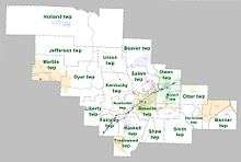
Townships in Arkansas are the divisions of a county. Each township includes unincorporated areas; some may have incorporated cities or towns within part of their boundaries. Arkansas townships have limited purposes in modern times. However, the United States Census does list Arkansas population based on townships (sometimes referred to as "county subdivisions" or "minor civil divisions"). Townships are also of value for historical purposes in terms of genealogical research. Each town or city is within one or more townships in an Arkansas county based on census maps and publications. The townships of Saline County are listed below; listed in parentheses are the cities, towns, and/or census-designated places that are fully or partially inside the township. [13][14]
- Banner (contains most of East End)
- Bauxite (contains Bauxite, most of Benton)
- Beaver (contains Avilla, part of Bryant)
- Bryant (contains most of Alexander and Bryant, small parts of Benton and Shannon Hills)
- Dyer (contains part of Hot Springs Village)
- Fairplay
- Haskell (contains Haskell)
- Holland
- Hurricane (contains small part of East End)
- Jefferson
- Kentucky
- Liberty
- Marble (contains part of Hot Springs Village)
- Newcomb
- Otter (contains most of Shannon Hills, small parts of Alexander and East End)
- Owen (contains some of Bryant, small part of Alexander)
- Salem (contains Salem, small part of Bryant)
- Shaw
- Smith
- Traskwood (contains Traskwood)
- Union
Source:[15]
See also
- List of lakes in Saline County, Arkansas
- National Register of Historic Places listings in Saline County, Arkansas
- Lanny Fite
References
- "State & County QuickFacts". United States Census Bureau. Retrieved May 19, 2014.
- "Find a County". National Association of Counties. Retrieved 2011-06-07.
- "2010 Census Gazetteer Files". United States Census Bureau. August 22, 2012. Retrieved August 27, 2015.
- "Population and Housing Unit Estimates". Retrieved September 28, 2019.
- "U.S. Decennial Census". United States Census Bureau. Retrieved August 27, 2015.
- "Historical Census Browser". University of Virginia Library. Retrieved August 27, 2015.
- Forstall, Richard L., ed. (March 27, 1995). "Population of Counties by Decennial Census: 1900 to 1990". United States Census Bureau. Retrieved August 27, 2015.
- "Census 2000 PHC-T-4. Ranking Tables for Counties: 1990 and 2000" (PDF). United States Census Bureau. April 2, 2001. Retrieved August 27, 2015.
- Based on 2000 census data
- "U.S. Census website". United States Census Bureau. Retrieved 2011-05-14.
- "Contact | The Saline Courier". www.bentoncourier.com. Retrieved 2018-05-28.
- "Dave Leip's Atlas of U.S. Presidential Elections". Retrieved November 18, 2016.
- 2011 Boundary and Annexation Survey (BAS): Saline County, AR (PDF) (Map). U. S. Census Bureau. Archived from the original (PDF) on 2012-10-19. Retrieved 2011-08-16.
- "Arkansas: 2010 Census Block Maps - County Subdivision". United States Census Bureau. Retrieved May 29, 2014.
-
"Summary Population and Housing Characteristics, CPH-1-5, Arkansas" (PDF). 2010 Census of Population and Housing. United States Census Bureau. September 2012. Retrieved May 31, 2014. External link in
|work=(help)
External links
- Government
- General information

- Saline County, Arkansas at ARGenWeb (argenweb.net)
- Saline County at Encyclopedia of Arkansas History & Culture
- Saline County in the Civil War at The Historical Marker Database (HMdb.org)
- Saline County Library
Places adjacent to Saline County, Arkansas | ||||||||||
|---|---|---|---|---|---|---|---|---|---|---|
| ||||||||||
Municipalities and communities of Saline County, Arkansas, United States | ||
|---|---|---|
| Cities | Map of Arkansas highlighting Saline County | |
| Towns | ||
| CDPs | ||
| Unincorporated communities | ||
| Footnotes | ‡This populated place also has portions in an adjacent county or counties | |

| Authority control |
|
|---|