Crittenden County, Arkansas
Crittenden County is a county located in the U.S. state of Arkansas. As of the 2010 census, the population was 50,902.[1] The county seat is Marion,[2] and the largest city is West Memphis. Crittenden County is Arkansas's 12th county, formed October 22, 1825, and named for Robert Crittenden,[3] the first Secretary of the Arkansas Territory.
Crittenden County | |
|---|---|
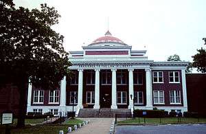 Crittenden County Courthouse in Marion | |
 Location within the U.S. state of Arkansas | |
 Arkansas's location within the U.S. | |
| Coordinates: 35°14′N 90°18′W | |
| Country | |
| State | |
| Founded | October 22, 1825 |
| Named for | Robert Crittenden |
| Seat | Marion |
| Largest city | West Memphis |
| Area | |
| • Total | 636 sq mi (1,650 km2) |
| • Land | 610 sq mi (1,600 km2) |
| • Water | 27 sq mi (70 km2) 4.2%% |
| Population (2010) | |
| • Total | 50,902 |
| • Estimate (2019) | 47,955 |
| • Density | 80/sq mi (31/km2) |
| Time zone | UTC−6 (Central) |
| • Summer (DST) | UTC−5 (CDT) |
| Congressional district | 1st |
| Website | http://crittenden.ark.org/ |

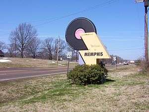
Crittenden County is part of the Memphis, TN-MS-AR Metropolitan Statistical Area. Most of the county's media comes from Memphis, although some Little Rock TV (Arkansas Educational Television Network, KATV) is imported by Comcast Cable. It lies within Arkansas's 1st congressional district.
Geography
According to the U.S. Census Bureau, the county has a total area of 636 square miles (1,650 km2), of which 610 square miles (1,600 km2) is land and 27 square miles (70 km2) (4.2%) is water.[4]
Adjacent counties
- Mississippi County (northeast)
- Tipton County, Tennessee (east)
- Shelby County, Tennessee (east)
- DeSoto County, Mississippi (southeast)
- Tunica County, Mississippi (south)
- Lee County (southwest)
- St. Francis County (west)
- Cross County (west)
- Poinsett County (northwest)
National protected area
Demographics
| Historical population | |||
|---|---|---|---|
| Census | Pop. | %± | |
| 1830 | 1,272 | — | |
| 1840 | 1,561 | 22.7% | |
| 1850 | 2,648 | 69.6% | |
| 1860 | 4,920 | 85.8% | |
| 1870 | 3,831 | −22.1% | |
| 1880 | 9,415 | 145.8% | |
| 1890 | 13,940 | 48.1% | |
| 1900 | 14,529 | 4.2% | |
| 1910 | 22,447 | 54.5% | |
| 1920 | 29,309 | 30.6% | |
| 1930 | 39,717 | 35.5% | |
| 1940 | 42,473 | 6.9% | |
| 1950 | 47,184 | 11.1% | |
| 1960 | 47,564 | 0.8% | |
| 1970 | 48,106 | 1.1% | |
| 1980 | 49,499 | 2.9% | |
| 1990 | 49,939 | 0.9% | |
| 2000 | 50,866 | 1.9% | |
| 2010 | 50,902 | 0.1% | |
| Est. 2019 | 47,955 | [5] | −5.8% |
| U.S. Decennial Census[6] 1790–1960[7] 1900–1990[8] 1990–2000[9] 2010–2016[1] | |||
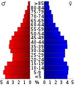
As of the 2010 census, there were 50,902 people living in the county. 51.2% were Black or African American, 46.1% White, 0.6% Asian, 0.3% Native American, 0.8% of some other race and 1.1% of two or more races. 2.0% were Hispanic or Latino (of any race).
As of the 2000 census,[11] there were 50,866 people, 18,471 households, and 13,373 families living in the county. The population density was 83 people per square mile (32/km²). There were 20,507 housing units at an average density of 34 per square mile (13/km²). The racial makeup of the county was 50.91% White, 47.05% Black or African American, 0.24% Native American, 0.47% Asian, 0.02% Pacific Islander, 0.66% from other races, and 0.64% from two or more races. 1.42% of the population were Hispanic or Latino of any race.
There were 18,471 households out of which 37.40% had children under the age of 18 living with them, 45.80% were married couples living together, 21.30% had a female householder with no husband present, and 27.60% were non-families. 23.70% of all households were made up of individuals and 8.00% had someone living alone who was 65 years of age or older. The average household size was 2.72 and the average family size was 3.23.
In the county, the population was spread out with 31.10% under the age of 18, 9.40% from 18 to 24, 29.10% from 25 to 44, 20.50% from 45 to 64, and 9.90% who were 65 years of age or older. The median age was 32 years. For every 100 females there were 91.00 males. For every 100 females age 18 and over, there were 85.00 males.
The median income for a household in the county was $30,109, and the median income for a family was $34,982. Males had a median income of $31,299 versus $21,783 for females. The per capita income for the county was $14,424. About 21.00% of families and 25.30% of the population were below the poverty line, including 35.30% of those under age 18 and 23.70% of those age 65 or over.
Education
Elementary and secondary education
Public education for elementary and secondary school students is available from Marion School District, West Memphis School District Earle School District, which leads to graduation from Earle High School. The Old Earle High School is listed on the National Register of Historic Places. Is also available in West Memphis and Marion.
Postsecondary education
Crittenden County is served by Arkansas State University Mid-South in West Memphis. The college offers bachelor's and master's degree programs in conjunction with Arkansas State University, The University of Arkansas, The University of Central Arkansas, Arkansas Tech University and Franklin University.[12]
Healthcare
Crittenden County was served by 152 Bed Crittenden Regional Hospital in West Memphis until late August 2014.[13] The hospital operated a number of outpatient clinics in Marion and West Memphis and a Pediatric Dental Clinic in cooperation with the UT Dental School.[14] Crittenden Regional Hospital has closed the ER and will permanently close on 7 September 2014.[15]
The nearest hospitals are located in Memphis, Tennessee.
The Arkansas Department of Health operates a clinic in West Memphis.[16]
A number of private clinics also operate in Marion and West Memphis.[17]
Government
Crittenden County in the nineteenth century was largely dominated by black Republicans, who carried the county in most elections from Reconstruction until the “Redeemers” disfranchised essentially all blacks in Arkansas between 1900 and 1960. From 1910 until 1944 it was overwhelmingly Democratic as only whites voted, and when faced with a national Civil Rights plank Crittenden was one of three Arkansas counties to vote for Strom Thurmond over Harry S. Truman in 1948. Since the re-enfranchisement of black residents began in the 1950s, Crittenden has been generally Democratic-voting, despite a large-scale shift of white residents to the GOP, reversing the nineteenth century party alignment. The last Republican to win the county was George Bush senior in 1988.
| Year | GOP | Dem | Others |
|---|---|---|---|
| 2016 | 43.66% 6,964 | 52.72% 8,410 | 3.63% 578 |
| 2012 | 41.86% 6,998 | 56.75% 9,487 | 1.38% 231 |
| 2008 | 41.91% 7,650 | 56.59% 10,330 | 1.51% 275 |
| 2004 | 45.29% 6,930 | 54.10% 8,277 | 0.61% 93 |
| 2000 | 44.26% 5,857 | 54.59% 7,224 | 1.15% 153 |
| 1996 | 32.83% 4,673 | 59.11% 8,415 | 8.06% 1,148 |
| 1992 | 34.55% 5,910 | 56.60% 9,683 | 8.86% 1,515 |
| 1988 | 51.73% 7,441 | 46.59% 6,702 | 1.68% 241 |
| 1984 | 47.82% 6,663 | 46.79% 6,520 | 5.39% 751 |
| 1980 | 45.20% 6,248 | 50.80% 7,022 | 4.00% 553 |
| 1976 | 38.63% 5,202 | 61.26% 8,249 | 0.10% 14 |
| 1972 | 71.06% 7,971 | 28.94% 3,246 | 0.00% 0 |
| 1968 | 23.18% 2,454 | 32.83% 3,475 | 43.99% 4,657 |
| 1964 | 48.96% 4,065 | 50.20% 4,168 | 0.83% 69 |
| 1960 | 43.56% 2,234 | 52.24% 2,679 | 4.19% 215 |
| 1956 | 50.81% 2,476 | 43.51% 2,120 | 5.68% 277 |
| 1952 | 38.34% 1,865 | 61.31% 2,982 | 0.35% 17 |
| 1948 | 5.73% 137 | 24.83% 594 | 69.44% 1,661 |
| 1944 | 19.38% 372 | 80.63% 1,548 | 0.00% 0 |
| 1940 | 3.53% 72 | 96.37% 1,966 | 0.10% 2 |
| 1936 | 1.17% 22 | 98.83% 1,858 | 0.00% 0 |
| 1932 | 1.51% 37 | 98.25% 2,411 | 0.24% 6 |
| 1928 | 15.68% 304 | 84.32% 1,635 | 0.00% 0 |
| 1924 | 8.81% 77 | 88.90% 777 | 2.29% 20 |
| 1920 | 15.46% 167 | 83.80% 905 | 0.74% 8 |
| 1916 | 13.91% 91 | 86.09% 563 | 0.00% 0 |
| 1912 | 11.17% 89 | 53.07% 423 | 35.76% 285 |
| 1908 | 46.59% 382 | 52.20% 428 | 1.22% 10 |
| 1904 | 54.14% 412 | 45.20% 344 | 0.66% 5 |
| 1900 | 53.21% 381 | 45.67% 327 | 1.12% 8 |
| 1896 | 28.89% 258 | 69.99% 625 | 1.12% 10 |
Transportation
Major highways
_Metric.svg.png)
_Metric.svg.png)
.svg.png)
.svg.png)
.svg.png)
.svg.png)
.svg.png)


Airports
Crittenden County is served by the West Memphis Municipal Airport (KAWM),[19] a General Aviation facility with a Control Tower and Instrument Landing capabilities.[20] General DeWitt Spain Airport is a civil aviation airport just north of downtown Memphis.
The Memphis International Airport is nearby and provides commercial aviation through numerous carriers and is the international cargo hub for FedEx.
Rail
Union Pacific operates a 600 Acre intermodal facility west of Marion, Arkansas.[21] BNSF Railway also operates a yard in Marion.
Limited Passenger Rail is available on Amtrak at Memphis Central Station in nearby Memphis. The City of New Orleans runs twice daily on a north–south route from Chicago to New Orleans.[22]
Water
Crittenden County and West Memphis jointly operate a port on the Mississippi River.[23] The International Port of Memphis lies just across the Mississippi River via ![]()
Communities
Cities
- Earle
- Marion (county seat)
- Turrell
- West Memphis
Towns
Townships

Townships in Arkansas are the divisions of a county. Each township includes unincorporated areas; some may have incorporated cities or towns within part of their boundaries. Arkansas townships have limited purposes in modern times. However, the United States Census does list Arkansas population based on townships (sometimes referred to as "county subdivisions" or "minor civil divisions"). Townships are also of value for historical purposes in terms of genealogical research. Each town or city is within one or more townships in an Arkansas county based on census maps and publications. The townships of Crittenden County are listed below; listed in parentheses are the cities, towns, and/or census-designated places that are fully or partially inside the township. [25][26]
- Black Oak
- Bob Ward (Anthonyville, Edmondson, small part of Jennette)
- Fogleman (Gilmore, Turrell)
- Jackson (Crawfordsville, part of Marion, part of West Memphis small part of Jennette)
- Jasper (Sunset, most of Marion, part of West Memphis, small part of Clarkedale)
- Lucas (Horseshoe Lake)
- Mississippi (most of West Memphis, part of Marion)
- Mound City (part of Marion, part of West Memphis, small part of Clarkedale)
- Proctor (part of West Memphis)
- Tyronza (Earle, most of Jennette)
- Wappanocca (Jericho, most of Clarkedale)
See also
- List of lakes in Crittenden County, Arkansas
References
| Wikimedia Commons has media related to Crittenden County, Arkansas. |
- "State & County QuickFacts". United States Census Bureau. Archived from the original on December 22, 2015. Retrieved May 20, 2014.
- "Find a County". National Association of Counties. Archived from the original on May 31, 2011. Retrieved 2011-06-07.
- Gannett, Henry (1905). The Origin of Certain Place Names in the United States. Govt. Print. Off. p. 96.
- "2010 Census Gazetteer Files". United States Census Bureau. August 22, 2012. Retrieved August 25, 2015.
- "Population and Housing Unit Estimates". Retrieved September 28, 2019.
- "U.S. Decennial Census". United States Census Bureau. Retrieved August 25, 2015.
- "Historical Census Browser". University of Virginia Library. Retrieved August 25, 2015.
- Forstall, Richard L., ed. (March 27, 1995). "Population of Counties by Decennial Census: 1900 to 1990". United States Census Bureau. Retrieved August 25, 2015.
- "Census 2000 PHC-T-4. Ranking Tables for Counties: 1990 and 2000" (PDF). United States Census Bureau. April 2, 2001. Retrieved August 25, 2015.
- Based on 2000 census data
- "U.S. Census website". United States Census Bureau. Retrieved 2011-05-14.
- "ASU Mid-South | West Memphis, Arkansas |". ASU Mid-South | West Memphis, Arkansas. Retrieved Jun 15, 2020.
- "Crittenden Online Income Blog". Crittenden Online Income Blog. Retrieved Jun 15, 2020.
- "Archived copy". Archived from the original on 2012-03-10. Retrieved 2012-02-21.CS1 maint: archived copy as title (link)
- "Archived copy". Archived from the original on 2014-08-30. Retrieved 2014-09-01.CS1 maint: archived copy as title (link)
- "Archived copy". Archived from the original on 2012-03-22. Retrieved 2012-02-21.CS1 maint: archived copy as title (link)
- http://www.arkmed.org/cgi-bin/cgiwrap/arkmed/htmlos.cgi/001366.7.385675122412990438%5B%5D
- "Dave Leip's Atlas of U.S. Presidential Elections". Retrieved November 18, 2016.
- "Archived copy". Archived from the original on 2012-05-09. Retrieved 2012-02-21.CS1 maint: archived copy as title (link)
- "AirNav: KAWM - West Memphis Municipal Airport". www.airnav.com. Retrieved Jun 15, 2020.
- "Archived copy" (PDF). Archived from the original (PDF) on 2012-04-17. Retrieved 2012-02-21.CS1 maint: archived copy as title (link)
- http://www.amtrak.com/servlet/ContentServer?c=AM_Route_C&pagename=am%2FLayout&cid=1241245653236
- http://westmemphis.com/industrial-sites/better-access/river
- "Archived copy". Archived from the original on 2010-03-07. Retrieved 2010-07-02.CS1 maint: archived copy as title (link)
- 2011 Boundary and Annexation Survey (BAS): Crittenden County, AR (PDF) (Map). U. S. Census Bureau. Archived from the original (PDF) on 2012-10-19. Retrieved 2011-08-20.
- "Arkansas: 2010 Census Block Maps - County Subdivision". United States Census Bureau. Retrieved May 27, 2014.
Places adjacent to Crittenden County, Arkansas | ||||||||||
|---|---|---|---|---|---|---|---|---|---|---|
| ||||||||||
Municipalities and communities of Crittenden County, Arkansas, United States | ||
|---|---|---|
| Cities | Map of Arkansas highlighting Crittenden County | |
| Towns | ||
| Unincorporated communities | ||


| Authority control |
|
|---|