Clark County, Arkansas
Clark County is a county located in the south-central part of the U.S. state of Arkansas. As of the 2010 census, the population was 22,995.[1] The county seat is Arkadelphia.[2] The Arkadelphia, AR Micropolitan Statistical Area includes all of Clark County.
Clark County | |
|---|---|
_001.jpg) Clark County Courthouse in Arkadelphia | |
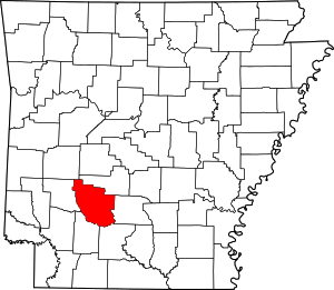 Location within the U.S. state of Arkansas | |
 Arkansas's location within the U.S. | |
| Coordinates: 34°05′20″N 93°09′50″W | |
| Country | |
| State | |
| Founded | December 15, 1818 |
| Named for | William Clark |
| Seat | Arkadelphia |
| Largest city | Arkadelphia |
| Area | |
| • Total | 883 sq mi (2,290 km2) |
| • Land | 866 sq mi (2,240 km2) |
| • Water | 17 sq mi (40 km2) 1.9%% |
| Population (2010) | |
| • Total | 22,995 |
| • Estimate (2019) | 22,320 |
| • Density | 26/sq mi (10/km2) |
| Time zone | UTC−6 (Central) |
| • Summer (DST) | UTC−5 (CDT) |
| Congressional district | 4th |
| Website | www |
History
Ancient Indigenous peoples occupied areas along the waterways for thousands of years prior to European exploration. Among the various cultures was the Caddoan Mississippian culture, which developed by 1000CE and occupied certain sites in Arkansas at different times. This was the westernmost expression of the Mississippian culture, which developed a vast network and numerous centers of development throughout the Mississippi Valley and its tributaries. The Caddoans constructed substantial earthwork mounds in the areas of Arkansas and Texas; the largest in Arkansas is Battle Mound Site, built from 1200-1400 CE in what is present-day Lafayette County. Archeological evidence has established there was unbroken continuity from the Caddoan Mississippian people to the historic Caddo people and related Caddo-language speakers who encountered the first Europeans. Their descendants formed the modern Caddo Nation of Oklahoma.[3]
19th century
Settlers in the 19th century found earthwork mounds, ten to 15 feet in height, in areas around what developed as Arkadelphia, Arkansas. Some were excavated for pottery and other grave goods.[4]
At the time of European-American settlement after the United States acquired this territory in the Louisiana Purchase of 1803, the pioneers encountered three major Native American tribes: the Caddo, who lived along the banks of the Caddo River; the Quapaw on the Ouachita River, for several miles below what is now Arkadelphia; and the Lenape (known then as Delaware, who were driven to this area by European pressure from the mid-Atlantic East Coast) along the lower Ouachita to below present-day Camden. (This site had been named as Écore à Fabre, after a colonial French trader Fabre.)[4]
Clark County was the third county formed by Americans in Arkansas, on December 15, 1818, together with Hempstead and Pulaski counties. The county is named after William Clark, then Governor of the Missouri Territory, which included present-day Arkansas. On November 1, 1833, the Arkansas territorial legislature created Pike County from western Clark County and part of northern Hempstead County. It was named after US explorer Zebulon Pike.
Arkadelphia was designated as the county seat in 1842. It became increasingly important as a hub after railroads were constructed to here that connected with numerous markets. Timber harvesting became important by the end of the century. By 1890, forest products were ranked next to agriculture in economic importance. In the 20th century, continued modern technological developments established the industry's continued importance in the county's economy.
Three of the six lynchings recorded in Clark County from 1877 to 1950[5] took place in a mass event in late January 1879. An African-American man, Ben Daniels, and three of his four sons (ranging in age from 22 to 18) were arrested as suspects in an alleged robbery and assault of a white man and held in the county jail. Daniels and two of his sons were forcibly taken out of the jail by a white mob and lynched by hanging from trees in the courthouse square, without trial. One son, believed to be Charles Daniels (22), survived for trial. He was convicted and served in prison until about 1886 or 1887.[6]
20th century to present
From 1920 to 1960, the county population declined, as may be seen on the table below. The cotton culture had been affected by the invasion of the boll weevil, which attacked the plants; and mechanization of agriculture, reducing the need for workers. In this period, many African-American families, who still constituted most of the farm workers, also left Arkansas and other parts of the rural South to escape Jim Crow oppression and seek better employment in Northern and Midwestern cities in the Great Migration. In the latter part of this period, some migrated to the West Coast, where the defense industry developed during and after World War II offered higher paying jobs.
At the same time, the lumber industry declined, also causing a loss of jobs. Several companies had operated sawmills and related businesses in Clark County in the early part of the century. The founders of the lumber town Graysonia, Arkansas moved to Springfield, Oregon, renaming their company as Roseboro Lumber. While manufacturing industries had entered the county, several had a downturn in the 1980s.
In the 1970s, the DeGray Dam and Lake were completed along the Caddo River, providing new areas in the county for tourism and recreation, which have become major components of the economy.
Geography
According to the U.S. Census Bureau, the county has a total area of 883 square miles (2,290 km2), of which 866 square miles (2,240 km2) is land and 17 square miles (44 km2) (1.9%) is water.[7]
Major highways
.svg.png)


Adjacent counties
- Hot Spring County (northeast)
- Dallas County (east)
- Ouachita County (southeast)
- Nevada County (southwest)
- Pike County (west)
- Montgomery County (northwest)
Demographics
| Historical population | |||
|---|---|---|---|
| Census | Pop. | %± | |
| 1830 | 1,369 | — | |
| 1840 | 2,309 | 68.7% | |
| 1850 | 4,070 | 76.3% | |
| 1860 | 9,735 | 139.2% | |
| 1870 | 11,953 | 22.8% | |
| 1880 | 15,771 | 31.9% | |
| 1890 | 20,997 | 33.1% | |
| 1900 | 21,289 | 1.4% | |
| 1910 | 23,686 | 11.3% | |
| 1920 | 25,632 | 8.2% | |
| 1930 | 24,932 | −2.7% | |
| 1940 | 24,402 | −2.1% | |
| 1950 | 22,998 | −5.8% | |
| 1960 | 20,950 | −8.9% | |
| 1970 | 21,537 | 2.8% | |
| 1980 | 23,326 | 8.3% | |
| 1990 | 21,437 | −8.1% | |
| 2000 | 23,546 | 9.8% | |
| 2010 | 22,995 | −2.3% | |
| Est. 2019 | 22,320 | [8] | −2.9% |
| U.S. Decennial Census[9] 1790–1960[10] 1900–1990[11] 1990–2000[12] 2010–2016[1] | |||
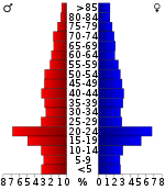
As of the 2000 census,[14] there were 23,546 people, 8,912 households, and 5,819 families residing in the county. The population density was 27 people per square mile (10/km²). There were 10,166 housing units at an average density of 12 per square mile (5/km²). The racial makeup of the county was 74.28% White, 22.02% Black or African American, 0.46% Native American, 0.62% Asian, 0.04% Pacific Islander, 1.37% from other races, and 1.20% from two or more races. 2.40% of the population were Hispanic or Latino of any race.
There were 8,912 households out of which 29.80% had children under the age of 18 living with them, 49.80% were married couples living together, 12.20% had a female householder with no husband present, and 34.70% were non-families. 27.60% of all households were made up of individuals and 12.40% had someone living alone who was 65 years of age or older. The average household size was 2.38 and the average family size was 2.91.
In the county, the population was spread out with 21.70% under the age of 18, 20.00% from 18 to 24, 23.80% from 25 to 44, 19.90% from 45 to 64, and 14.60% who were 65 years of age or older. The median age was 32 years. For every 100 females there were 92.70 males. For every 100 females age 18 and over, there were 88.90 males.
The median income for a household in the county was $28,845, and the median income for a family was $37,092. Males had a median income of $28,692 versus $19,886 for females. The per capita income for the county was $14,533. About 13.50% of families and 19.10% of the population were below the poverty line, including 20.90% of those under age 18 and 18.40% of those age 65 or over.
Government
Over the past few election cycles Clark County has trended towards the GOP. The last Democrat (as of 2016) to carry this county was John Kerry in 2004.
| Year | GOP | Dem | Others |
|---|---|---|---|
| 2016 | 51.65% 4,404 | 42.46% 3,620 | 5.88% 502 |
| 2012 | 51.65% 4,343 | 45.32% 3,811 | 3.03% 255 |
| 2008 | 50.67% 4,608 | 46.92% 4,267 | 2.41% 219 |
| 2004 | 44.99% 4,144 | 54.17% 4,990 | 0.84% 77 |
| 2000 | 43.77% 3,776 | 54.03% 4,661 | 2.19% 189 |
| 1996 | 26.00% 2,112 | 65.02% 5,281 | 8.97% 729 |
| 1992 | 26.93% 2,403 | 64.64% 5,767 | 8.43% 752 |
| 1988 | 41.69% 3,389 | 57.50% 4,675 | 0.81% 66 |
| 1984 | 47.27% 4,185 | 52.39% 4,638 | 0.34% 30 |
| 1980 | 29.97% 2,743 | 66.89% 6,122 | 3.15% 288 |
| 1976 | 21.42% 1,816 | 78.32% 6,641 | 0.26% 22 |
| 1972 | 59.96% 4,173 | 39.38% 2,741 | 0.66% 46 |
| 1968 | 22.96% 1,642 | 38.22% 2,733 | 38.82% 2,776 |
| 1964 | 31.21% 1,884 | 68.36% 4,127 | 0.43% 26 |
| 1960 | 26.70% 1,357 | 64.82% 3,295 | 8.48% 431 |
| 1956 | 40.76% 1,973 | 58.04% 2,809 | 1.20% 58 |
| 1952 | 36.13% 1,679 | 63.76% 2,963 | 0.11% 5 |
| 1948 | 15.27% 383 | 69.75% 1,750 | 14.99% 376 |
| 1944 | 24.30% 637 | 75.58% 1,981 | 0.11% 3 |
| 1940 | 13.36% 311 | 86.29% 2,008 | 0.34% 8 |
| 1936 | 8.92% 193 | 90.71% 1,962 | 0.37% 8 |
| 1932 | 5.66% 183 | 93.88% 3,037 | 0.46% 15 |
| 1928 | 33.37% 913 | 66.41% 1,817 | 0.22% 6 |
| 1924 | 25.29% 483 | 64.03% 1,223 | 10.68% 204 |
| 1920 | 40.06% 1,020 | 59.19% 1,507 | 0.75% 19 |
| 1916 | 25.56% 678 | 74.44% 1,975 | 0.00% 0 |
| 1912 | 21.78% 376 | 60.89% 1,051 | 17.33% 299 |
| 1908 | 43.48% 1,007 | 52.07% 1,206 | 4.45% 103 |
| 1904 | 44.74% 732 | 44.13% 722 | 11.12% 182 |
| 1900 | 35.54% 753 | 58.14% 1,232 | 6.32% 134 |
| 1896 | 29.49% 833 | 67.61% 1,910 | 2.90% 82 |
Communities
Cities
- Amity
- Arkadelphia (county seat)
- Gurdon
Townships
Note: Unlike most Arkansas counties, Clark County has only one township. That township encompasses the entire county.
Townships in Arkansas are the divisions of a county. Each township includes unincorporated areas; some may have incorporated cities or towns within part of their boundaries. Arkansas townships have limited purposes in modern times. However, the United States Census does list Arkansas population based on townships (sometimes referred to as "county subdivisions" or "minor civil divisions"). Townships are also of value for historical purposes in terms of genealogical research. Each town or city is within one or more townships in an Arkansas county based on census maps and publications. The townships of Clark County are listed below; listed in parentheses are the cities, towns, and/or census-designated places that are fully or partially inside the township. [16][17]
- Caddo
Notable residents
- Daniel Davis, actor, best known for playing "Niles the butler" in the television series The Nanny, was born in Gurdon.
- Jody Evans, singer of country music, started his music career in Clark County, and works for the Arkadelphia Police Department.
- Cliff Harris, football player, Dallas Cowboys NFL, played college football for the Ouachita Baptist University football team.
- Bob C. Riley, politician, was born and raised in Arkadelphia. The Democrat served as Lieutenant Governor from 1971–1975.
- Jerry Thomasson, politician and state representative, was born and raised in Arkadelphia. He switched to the Republican Party in 1966 and ran unsuccessfully for state attorney general in 1966 and 1968.
- Billy Bob Thornton, film actor, grew up in Alpine.
See also
- List of lakes in Clark County, Arkansas
- National Register of Historic Places listings in Clark County, Arkansas
References
- "State & County QuickFacts". United States Census Bureau. Archived from the original on July 8, 2011. Retrieved May 20, 2014.
- "Find a County". National Association of Counties. Archived from the original on 2011-05-31. Retrieved 2011-06-07.
- "Tejas-Caddo Fundamentals-Caddoan Languages and Peoples". Archived from the original on 2010-03-10. Retrieved 2010-02-04.
- Laura Scott Butler, "History of Clark County" Archived 2016-09-15 at the Wayback Machine, Publications of The Arkansas Historical Association; Edited by John Hugh Reynolds; Vol. 1; 1906
- "Summary: Lynching in America, 3rd edition, 2015" (PDF). Archived from the original (PDF) on 2017-10-23. Retrieved 2017-10-22.
- Nancy Snell Griffith, "Arkadelphia Lynching of 1879/ aka: Lynching of Daniels Family" Archived 2017-10-23 at the Wayback Machine, Arkansas Encyclopedia of History and Culture, 11 February 2016; accessed 22 October 2017
- "2010 Census Gazetteer Files". United States Census Bureau. August 22, 2012. Archived from the original on September 4, 2015. Retrieved August 25, 2015.
- "Population and Housing Unit Estimates". Archived from the original on May 29, 2017. Retrieved September 28, 2019.
- "U.S. Decennial Census". United States Census Bureau. Retrieved August 25, 2015.
- "Historical Census Browser". University of Virginia Library. Archived from the original on August 11, 2012. Retrieved August 25, 2015.
- Forstall, Richard L., ed. (March 27, 1995). "Population of Counties by Decennial Census: 1900 to 1990". United States Census Bureau. Archived from the original on September 24, 2015. Retrieved August 25, 2015.
- "Census 2000 PHC-T-4. Ranking Tables for Counties: 1990 and 2000" (PDF). United States Census Bureau. April 2, 2001. Archived (PDF) from the original on December 18, 2014. Retrieved August 25, 2015.
- Based on 2000 census data
- "U.S. Census website". United States Census Bureau. Retrieved 2011-05-14.
- "Dave Leip's Atlas of U.S. Presidential Elections". Archived from the original on July 9, 2018. Retrieved November 18, 2016.
- 2011 Boundary and Annexation Survey (BAS): Clark County, AR (PDF) (Map). U. S. Census Bureau. Archived from the original (PDF) on 2012-10-19. Retrieved 2011-08-23.
- "Arkansas: 2010 Census Block Maps - County Subdivision". United States Census Bureau. Archived from the original on May 28, 2014. Retrieved May 27, 2014.
External links
- 1st Arkansas Infantry Regiment, CSA, Company B
- Lt. Andrew J. Pitner and Pvt. Charles Trickett, CSA Medal of Honor
- Stanford-Sellers murder, 1893
- Clark County Sheriff's Office
Places adjacent to Clark County, Arkansas | ||||||||||
|---|---|---|---|---|---|---|---|---|---|---|
| ||||||||||
Municipalities and communities of Clark County, Arkansas, United States | ||
|---|---|---|
| Cities | Map of Arkansas highlighting Clark County | |
| Towns | ||
| Unincorporated communities | ||

| Authority control |
|
|---|