Paragould, Arkansas
Paragould is the county seat of Greene County, and the 19th-largest city in Arkansas, in the United States. The city is located in northeastern Arkansas on the eastern edge of Crowley's Ridge, a geologic anomaly contained within the Arkansas delta.
Paragould, Arkansas | |
|---|---|
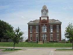
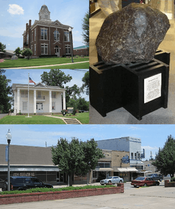 Clockwise from center: Paragould meteorite, Paragould Downtown Commercial Historic District, Greene County Museum, Historic Greene County Courthouse | |
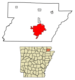 Location of Paragould in Greene County, Arkansas. | |
 Paragould, Arkansas Location in the United States | |
| Coordinates: 36°3′25″N 90°30′11″W | |
| Country | United States |
| State | Arkansas |
| County | Greene |
| Area | |
| • Total | 32.02 sq mi (82.93 km2) |
| • Land | 31.86 sq mi (82.51 km2) |
| • Water | 0.16 sq mi (0.42 km2) |
| Elevation | 299 ft (91 m) |
| Population (2010) | |
| • Total | 26,113 |
| • Estimate (2019)[2] | 28,986 |
| • Density | 909.88/sq mi (351.31/km2) |
| Time zone | UTC−6 (Central (CST)) |
| • Summer (DST) | UTC−5 (CDT) |
| ZIP codes | 72450-72451 |
| Area code(s) | 870 |
| FIPS code | 05-53390 |
| GNIS feature ID | 0077948 |
| Website | Official website |
Paragould is the principal city of the Paragould, Arkansas Micropolitan Statistical Area and is also a part of the Jonesboro-Paragould Combined Statistical Area. The Paragould micropolitan area's population was 42,090 at the 2010 census,[3] and the Jonesboro-Paragould Combined Statistical Area's population was 163,116.[4]
The city had a population of 26,113 at the 2010 census[5] and an estimated population of 28,986 in 2019.[6]
History
The city's name is a blend combining the last names of competing railroad magnates J. W. Paramore and Jay Gould. Paramore's Texas & St. Louis Railway (later the Cotton Belt) and Gould's St. Louis, Iron Mountain and Southern Railway (later the Missouri Pacific) intersected here in 1882. A group of citizens chose the name, and it is believed to be the only city in the world with this name. Gould objected to his name's being second and refused to list the new town on his schedules.[7]
Geography
Paragould is located southeast of the center of Greene County. U.S. Routes 412 and 49 intersect in the city west of downtown. US 412 leads east 9 miles (14 km) to the Missouri state line at the St. Francis River, and a further 23 miles (37 km) northeast to Kennett, Missouri; to the west US 412 leads 26 miles (42 km) to Walnut Ridge. US 49 leads northeast 32 miles (51 km) to Piggott and southwest 20 miles (32 km) to Jonesboro. The closest major city is Memphis, Tennessee, 82 miles (132 km) to the southeast.
According to the United States Census Bureau, the city has a total area of 31.4 square miles (81.2 km2), of which 31.2 square miles (80.8 km2) is land and 0.2 square miles (0.4 km2), or 0.52%, is water.[5]
Climate
Paragould has a humid subtropical climate (Köppen climate classification Cfa).
| Climate data for Paragould | |||||||||||||
|---|---|---|---|---|---|---|---|---|---|---|---|---|---|
| Month | Jan | Feb | Mar | Apr | May | Jun | Jul | Aug | Sep | Oct | Nov | Dec | Year |
| Record high °F (°C) | 73 (23) |
78 (26) |
89 (32) |
93 (34) |
94 (34) |
101 (38) |
106 (41) |
105 (41) |
100 (38) |
92 (33) |
82 (28) |
77 (25) |
106 (41) |
| Average high °F (°C) | 44 (7) |
51 (11) |
60 (16) |
70 (21) |
79 (26) |
88 (31) |
92 (33) |
90 (32) |
84 (29) |
74 (23) |
59 (15) |
49 (9) |
70 (21) |
| Average low °F (°C) | 26 (−3) |
31 (−1) |
41 (5) |
50 (10) |
60 (16) |
68 (20) |
72 (22) |
70 (21) |
63 (17) |
50 (10) |
40 (4) |
32 (0) |
50 (10) |
| Record low °F (°C) | −14 (−26) |
−1 (−18) |
5 (−15) |
19 (−7) |
40 (4) |
50 (10) |
54 (12) |
50 (10) |
36 (2) |
28 (−2) |
16 (−9) |
−6 (−21) |
−14 (−26) |
| Average precipitation inches (mm) | 3.49 (89) |
3.52 (89) |
4.93 (125) |
5.10 (130) |
4.96 (126) |
3.93 (100) |
3.09 (78) |
2.68 (68) |
3.11 (79) |
4.00 (102) |
5.35 (136) |
4.87 (124) |
48.23 (1,225) |
| Source: [8] | |||||||||||||
Demographics
| Historical population | |||
|---|---|---|---|
| Census | Pop. | %± | |
| 1890 | 1,666 | — | |
| 1900 | 3,324 | 99.5% | |
| 1910 | 5,248 | 57.9% | |
| 1920 | 6,306 | 20.2% | |
| 1930 | 5,966 | −5.4% | |
| 1940 | 7,079 | 18.7% | |
| 1950 | 9,668 | 36.6% | |
| 1960 | 9,947 | 2.9% | |
| 1970 | 10,639 | 7.0% | |
| 1980 | 15,248 | 43.3% | |
| 1990 | 18,540 | 21.6% | |
| 2000 | 22,017 | 18.8% | |
| 2010 | 26,113 | 18.6% | |
| Est. 2019 | 28,986 | [2] | 11.0% |
| U.S. Decennial Census[9] | |||
As of the 2010 United States Census, there were 26,113 people living in the city. The racial makeup of the city was 94.4% White, 0.8% Black, 0.4% Native American, 0.3% Asian, <0.1% Pacific Islander, <0.1% from some other race and 1.2% from two or more races. 2.8% were Hispanic or Latino of any race.
As of the census[10] of 2000, there were 22,017 people, 8,941 households, and 6,133 families living in the city. The population density was 714.6 people per square mile (275.9/km2). There were 9,789 housing units at an average density of 317.7 per square mile (122.7/km2). The racial makeup of the city was 97.87% White, 0.04% Black or African American, 0.42% Native American, 0.22% Asian, 0.02% Pacific Islander, 0.56% from other races, and 0.86% from two or more races. 1.33% of the population were Hispanic or Latino of any race.
There were 8,941 households, out of which 31.9% had children under the age of 18 living with them, 53.7% were married couples living together, 11.4% had a female householder with no husband present, and 31.4% were non-families. 27.5% of all households were made up of individuals, and 13.0% had someone living alone who was 65 years of age or older. The average household size was 2.40 and the average family size was 2.92.
In the city, the population was spread out, with 24.8% under the age of 18, 9.6% from 18 to 24, 28.0% from 25 to 44, 21.7% from 45 to 64, and 15.8% who were 65 years of age or older. The median age was 36 years. For every 100 females, there were 90.7 males. For every 100 females age 18 and over, there were 86.9 males.
The median income for a household in the city was $30,815, and the median income for a family was $39,431. Males had a median income of $28,103 versus $20,623 for females. The per capita income for the city was $18,076. About 8.4% of families and 12.0% of the population were below the poverty line, including 12.1% of those under age 18 and 12.1% of those age 65 or over.
Education
Paragould is home to the Arkansas State University Paragould campus, Crowley's Ridge College, and a campus of Black River Technical College. Paragould has two public school districts, the Greene County Tech School District and the Paragould School District, as well as Crowley's Ridge Academy and St. Mary's Catholic School private school systems.
The Northeast Arkansas School District was formed on July 1, 1985 by the merger of the former Paragould School District with the Oak Grove School District.[11] By 1997 the name of the new district became the Paragould School District.[12]
Infrastructure
Transportation
Highways
.svg.png)


Health care
Arkansas Methodist Medical Center is Paragould's only hospital. The 127-bed acute-care hospital's campus includes a professional office building with a community wellness center.
Law enforcement
On December 15, 2012, it was announced that "beginning in 2013, the department would deploy a new street crimes unit to high crime areas on foot to take back the streets."[13] The remaining town hall meetings to inform the public of the new plan were cancelled due to the volume of threats received as a result of national media exposure. This was done for public safety, as continuing to hold the meetings may have posed a danger to attendees. It is unknown at this time if the plan will still be put into effect.[14]
Notable people
- Weldon Bowlin, Major League Baseball player
- Jeanne Carmen, actress, glamour girl and famed trick-shot golfer
- Iris DeMent, singer-songwriter[15]
- Jimmie Lou Fisher, Arkansas State Treasurer, 2002 Democratic nominee for governor of Arkansas
- Junius Marion Futrell, governor of Arkansas, 1933–1937
- Trice Harvey, California politician
- Homer Lenderman, former state representative for Craighead and Greene counties
- Sam O'Steen, Academy Award-nominated editor.
- Mathew Pitsch, member of the Arkansas House of Representatives
- Lee Purcell, Emmy Award-nominated actress
- Marlin Stuart, Major League Baseball player
- George Taylor, Medal of Honor awardee for his actions during the Civil War
- Richard Travis, actor from 1940s films
- James Wayne Wood, former aeronautical engineer, U.S. Air Force officer, test pilot and astronaut in the X-20 Dyna-Soar program
References
- "2019 U.S. Gazetteer Files". United States Census Bureau. Retrieved June 30, 2020.
- "Population and Housing Unit Estimates". United States Census Bureau. May 24, 2020. Retrieved May 27, 2020.
- "Geographic Identifiers: 2010 Demographic Profile Data (G001): Paragould, AR Micro Area". American Factfinder. U.S. Census Bureau. Archived from the original on February 13, 2020. Retrieved November 14, 2016.
- "Geographic Identifiers: 2010 Demographic Profile Data (G001): Jonesboro-Paragould, AR CSA". American Factfinder. U.S. Census Bureau. Archived from the original on February 13, 2020. Retrieved November 14, 2016.
- "Geographic Identifiers: 2010 Demographic Profile Data (G001): Paragould city, Arkansas". American Factfinder. U.S. Census Bureau. Retrieved November 14, 2016.
- "Population and Housing Unit Estimates". Retrieved May 21, 2020.
- Temple, Robert D. Edge Effects: The Border-Name Places (2nd edition, 2009), iUniverse, ISBN 978-0-595-47758-6, page 320.
- "Average weather for Paragould, Arkansas". Weather.com. Retrieved December 21, 2008.
- "Census of Population and Housing". Census.gov. Retrieved June 4, 2015.
- "U.S. Census website". United States Census Bureau. Retrieved 2008-01-31.
- "ConsolidationAnnex_from_1983.xls." Arkansas Department of Education. Retrieved on October 13, 2017.
- Home. Paragould School District. February 11, 1997. Retrieved on October 14, 2017. "Paragould School District is a consolidated district comprising the former districts of Oak Grove, Stanford, and Paragould."
- "Armed task force to patrol streets". Archived from the original on January 31, 2013.
- "PPD cancels town hall events". Archived from the original on January 31, 2013.
- Iris DeMent profile, artistdirect.com; accessed April 8, 2015.
External links
Municipalities and communities of Greene County, Arkansas, United States | ||
|---|---|---|
| Cities | 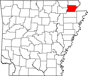 Map of Arkansas highlighting Greene County | |
| Towns | ||
| Unincorporated communities | ||
| Authority control |
|
|---|