Pope County, Arkansas
Pope County is a county in the U.S. state of Arkansas. As of the 2010 census, the population was 61,754.[1] The county seat is Russellville.[2] The county was formed on November 2, 1829, from a portion of Crawford County and named for John Pope, the third governor of the Arkansas Territory. It is an alcohol prohibition or dry county.
Pope County | |
|---|---|
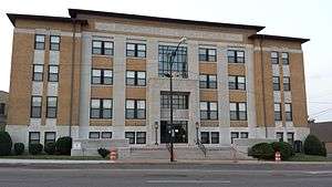 Pope County Courthouse | |
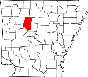 Location within the U.S. state of Arkansas | |
 Arkansas's location within the U.S. | |
| Coordinates: 35°25′35″N 93°01′55″W | |
| Country | |
| State | |
| Founded | November 2, 1829 |
| Named for | John Pope |
| Seat | Russellville |
| Largest city | Russellville |
| Area | |
| • Total | 831 sq mi (2,150 km2) |
| • Land | 813 sq mi (2,110 km2) |
| • Water | 18 sq mi (50 km2) 2.2%% |
| Population (2010) | |
| • Total | 61,754 |
| • Estimate (2019) | 64,072 |
| • Density | 74/sq mi (29/km2) |
| Time zone | UTC−6 (Central) |
| • Summer (DST) | UTC−5 (CDT) |
| Congressional district | 3rd |
| Website | www |
Pope County is part of the Russellville, AR Micropolitan Statistical Area.
History
Civil War and Reconstruction
A large Democratic majority was ardently split into a "town or country" dichotomy at the local level. Further, the county was split between Union and Confederate sympathizers, with deep grudges held by both sides for grievances committed during the opposite's rule during the war. After the war, Republicans controlled local government and the Democrats controlled the county economy. The political situation and cultural differences kept tensions high between the groups, occasionally resulting in violence. The most violent episode came to be known as the Pope County Militia War, a six-month drama involving robbery, plundering and murder. The state-controlled militia eventually arrived to enforce martial law in the county, making the local Democrats who were providing armed resistance to Governor Powell Clayton's Republican army heroes to Confederate sympathizers around the state.[3]
Geography
According to the U.S. Census Bureau, the county has a total area of 831 square miles (2,150 km2), of which 813 square miles (2,110 km2) is land and 18 square miles (47 km2) (2.2%) is water.[4]
Major highways
.svg.png)


.svg.png)
Adjacent counties
- Newton County (northwest)
- Searcy County (northeast)
- Van Buren County (northeast)
- Conway County (southeast)
- Yell County (south)
- Logan County (southwest)
- Johnson County (west)
National protected areas
- Holla Bend National Wildlife Refuge (part)
- Ozark National Forest (part)
- Centerville Dragway
Demographics
| Historical population | |||
|---|---|---|---|
| Census | Pop. | %± | |
| 1830 | 1,483 | — | |
| 1840 | 2,850 | 92.2% | |
| 1850 | 4,710 | 65.3% | |
| 1860 | 7,883 | 67.4% | |
| 1870 | 8,386 | 6.4% | |
| 1880 | 14,322 | 70.8% | |
| 1890 | 19,458 | 35.9% | |
| 1900 | 21,715 | 11.6% | |
| 1910 | 24,527 | 12.9% | |
| 1920 | 27,153 | 10.7% | |
| 1930 | 26,547 | −2.2% | |
| 1940 | 25,682 | −3.3% | |
| 1950 | 23,291 | −9.3% | |
| 1960 | 21,177 | −9.1% | |
| 1970 | 28,607 | 35.1% | |
| 1980 | 39,021 | 36.4% | |
| 1990 | 45,883 | 17.6% | |
| 2000 | 54,469 | 18.7% | |
| 2010 | 61,754 | 13.4% | |
| Est. 2019 | 64,072 | [5] | 3.8% |
| U.S. Decennial Census[6] 1790–1960[7] 1900–1990[8] 1990–2000[9] 2010–2017[10] | |||
As of the 2000 census,[12] there were 54,469 people, 20,701 households, and 15,008 families residing in the county. The population density was 67 people per square mile (26/km²). There were 22,851 housing units at an average density of 28 per square mile (11/km²). The racial makeup of the county was 93.73% White, 2.61% Black or African American, 0.68% Native American, 0.64% Asian, 0.03% Pacific Islander, 0.93% from other races, and 1.39% from two or more races. 2.06% of the population were Hispanic or Latino of any race.
There were 20,701 households out of which 34.30% had children under the age of 18 living with them, 58.60% were married couples living together, 10.20% had a female householder with no husband present, and 27.50% were non-families. 23.00% of all households were made up of individuals and 9.10% had someone living alone who was 65 years of age or older. The average household size was 2.55 and the average family size was 3.00.
In the county, the population was spread out with 25.50% under the age of 18, 11.60% from 18 to 24, 28.20% from 25 to 44, 21.90% from 45 to 64, and 12.70% who were 65 years of age or older. The median age was 35 years. For every 100 females, there were 96.40 males. For every 100 females age 18 and over, there were 94.10 males.
The median income for a household in the county was $32,069, and the median income for a family was $39,055. Males had a median income of $29,914 versus $19,307 for females. The per capita income for the county was $15,918. About 11.60% of families and 15.20% of the population were below the poverty line, including 18.80% of those under age 18 and 14.00% of those age 65 or over.
Government
Over The past few election cycles Pope County has trended heavily towards the GOP. The last democrat (as of 2016) to carry this county was Bill Clinton in 1996.
| Year | GOP | Dem | Others |
|---|---|---|---|
| 2016 | 72.03% 16,256 | 22.15% 5,000 | 5.82% 1,313 |
| 2012 | 72.23% 14,763 | 25.08% 5,126 | 2.69% 550 |
| 2008 | 70.51% 15,568 | 27.18% 6,002 | 2.31% 509 |
| 2004 | 65.13% 13,614 | 33.97% 7,100 | 0.90% 188 |
| 2000 | 61.04% 11,244 | 36.20% 6,669 | 2.77% 509 |
| 1996 | 43.75% 8,243 | 44.76% 8,433 | 11.49% 2,164 |
| 1992 | 45.10% 8,056 | 43.13% 7,704 | 11.77% 2,102 |
| 1988 | 66.68% 10,084 | 32.67% 4,941 | 0.65% 98 |
| 1984 | 67.28% 10,667 | 32.05% 5,082 | 0.67% 106 |
| 1980 | 50.72% 7,217 | 44.72% 6,364 | 4.56% 649 |
| 1976 | 34.15% 4,348 | 65.62% 8,355 | 0.23% 29 |
| 1972 | 67.52% 6,917 | 32.23% 3,302 | 0.24% 25 |
| 1968 | 38.30% 3,319 | 29.75% 2,578 | 31.95% 2,769 |
| 1964 | 34.07% 2,651 | 63.91% 4,972 | 2.02% 157 |
| 1960 | 46.04% 2,573 | 49.38% 2,760 | 4.58% 256 |
| 1956 | 44.94% 2,267 | 54.57% 2,753 | 0.50% 25 |
| 1952 | 42.27% 2,226 | 57.65% 3,036 | 0.08% 4 |
| 1948 | 20.56% 764 | 67.95% 2,525 | 11.49% 427 |
| 1944 | 28.14% 805 | 71.58% 2,048 | 0.28% 8 |
| 1940 | 16.88% 770 | 82.55% 3,765 | 0.57% 26 |
| 1936 | 11.49% 348 | 88.38% 2,678 | 0.13% 4 |
| 1932 | 10.36% 280 | 88.49% 2,391 | 1.15% 31 |
| 1928 | 36.11% 1,559 | 63.35% 2,735 | 0.53% 23 |
| 1924 | 21.23% 479 | 70.08% 1,581 | 8.69% 196 |
| 1920 | 34.24% 1,120 | 63.65% 2,082 | 2.11% 69 |
| 1916 | 26.71% 783 | 73.29% 2,148 | 0.00% 0 |
| 1912 | 13.14% 334 | 59.70% 1,517 | 27.15% 690 |
| 1908 | 31.56% 811 | 64.75% 1,664 | 3.70% 95 |
| 1904 | 36.64% 850 | 61.38% 1,424 | 1.98% 46 |
| 1900 | 30.68% 835 | 68.74% 1,871 | 0.59% 16 |
| 1896 | 24.60% 762 | 74.75% 2,315 | 0.65% 20 |
Townships
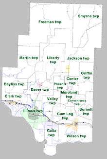
Townships in Arkansas are the divisions of a county. Each township includes unincorporated areas; some may have incorporated cities or towns within part of their boundaries. Arkansas townships have limited purposes in modern times. However, the United States Census does list Arkansas population based on townships (sometimes referred to as "county subdivisions" or "minor civil divisions"). Townships are also of value for historical purposes in terms of genealogical research. Each town or city is within one or more townships in an Arkansas county based on census maps and publications. The townships of Pope County are listed below; listed in parentheses are the cities, towns, and/or census-designated places that are fully or partially inside the township. [14][15]
Pope County formerly included 10 more townships. Allen Township was moved into Hogan Township around 1910, and Hill Township, Galla Creek Township, Independence Township, Lee Township, North Fork Township, Sand Spring Township, and Sulphur Township were also formerly active townships in Pope County. Holla Bend Township, containing the Holla Bend National Wildlife Refuge, has also been disbanded.
| Township | FIPS code | ANSI code (GNIS ID) |
Population center(s) |
Pop. (2010) |
Pop. density (/mi²) |
Pop. density (/km²) |
Land area (mi²) |
Land area (km²) |
Water area (mi²) |
Water area (km²) |
Geographic coordinates |
|---|---|---|---|---|---|---|---|---|---|---|---|
| Bayliss | 05-90159 | 69697 | 708 | 24.6 | 9.5 | 28.81 | 74.62 | 0.0979 | 0.2536 | 35°24′10″N 93°14′06″W | |
| Burnett | 05-90558 | 69698 | 452 | 20.9 | 8.1 | 21.65 | 56.07 | 0.1051 | 0.2722 | 35°19′10″N 92°52′33″W | |
| Center | 05-90735 | 69699 | 515 | 36.8 | 14.2 | 13.99 | 36.23 | 0.0339 | 0.0878 | 35°24′20″N 92°57′16″W | |
| Clark | 05-90813 | 69700 | London | 2969 | 115.3 | 44.6 | 25.73 | 66.64 | 6.0444 | 15.6549 | 35°19′45″N 93°14′46″W |
| Convenience | 05-90921 | 69701 | 933 | 50.4 | 19.4 | 18.53 | 47.99 | 0.0942 | 0.2440 | 35°20′00″N 92°56′41″W | |
| Dover | 05-91134 | 69702 | Dover | 5277 | 119.1 | 46.0 | 44.29 | 114.7 | 0.3637 | 0.9420 | 35°23′30″N 93°07′01″W |
| Freeman | 05-91377 | 69703 | 98 | 0.8 | 0.3 | 119.78 | 310.2 | 0.0000 | 0.0000 | 35°39′10″N 93°04′06″W | |
| Galla | 05-91407 | 69704 | Pottsville | 3523 | 88.7 | 34.3 | 39.71 | 102.8 | 1.8410 | 4.7682 | 35°13′15″N 93°02′46″W |
| Griffin | 05-91536 | 69705 | 901 | 26.5 | 10.2 | 33.96 | 87.96 | 0.1106 | 0.2865 | 35°25′30″N 92°52′36″W | |
| Gum Log | 05-91560 | 69706 | 1420 | 71.6 | 27.6 | 19.84 | 51.39 | 0.0142 | 0.0368 | 35°16′30″N 92°59′51″W | |
| Illinois | 05-91812 | 69707 | Russellville | 25841 | 540.9 | 208.9 | 47.77 | 123.7 | 6.6022 | 17.0996 | 35°17′00″N 93°07′46″W |
| Jackson | 05-91875 | 69708 | Hector | 1191 | 11.5 | 4.4 | 103.72 | 268.6 | 0.0505 | 0.1308 | 35°29′20″N 92°57′01″W |
| Liberty | 05-92181 | 69709 | 805 | 14.2 | 5.5 | 56.64 | 146.7 | 0.0028 | 0.0073 | 35°29′40″N 93°03′16″W | |
| Martin | 05-92415 | 69710 | 1482 | 23.7 | 9.2 | 62.46 | 161.8 | 0.3931 | 1.0181 | 35°28′25″N 93°10′06″W | |
| Moreland | 05-92553 | 69711 | 700 | 52.2 | 20.2 | 13.40 | 34.71 | 0.0683 | 0.1769 | 35°21′30″N 92°59′46″W | |
| Phoenix | 05-92871 | 69712 | 334 | 26.7 | 10.3 | 12.51 | 32.40 | 0.0000 | 0.0000 | 35°24′30″N 93°00′31″W | |
| Smyrna | 05-93420 | 69713 | 173 | 2.4 | 0.9 | 70.69 | 183.1 | 0.0218 | 0.0565 | 35°38′10″N 92°53′46″W | |
| Valley | 05-93765 | 69714 | 2776 | 125.7 | 48.5 | 22.09 | 57.21 | 0.0144 | 0.0373 | 35°20′05″N 93°02′46″W | |
| Wilson | 05-94089 | 69715 | Atkins | 4371 | 77.6 | 30.0 | 56.32 | 145.9 | 3.0305 | 7.8490 | 35°13′30″N 92°55′01″W |
| Source: "Census 2000 U.S. Gazetteer Files". U.S. Census Bureau, Geography Division. | |||||||||||
See also
- List of lakes in Pope County, Arkansas
- National Register of Historic Places listings in Pope County, Arkansas
Notes
- "State & County QuickFacts". United States Census Bureau. Archived from the original on September 5, 2015. Retrieved May 19, 2014.
- "Find a County". National Association of Counties. Retrieved 2011-06-07.
- Arsenault 1988, p. 29.
- "2010 Census Gazetteer Files". United States Census Bureau. August 22, 2012. Retrieved August 27, 2015.
- "U.S. Census website". United States Census Bureau. Retrieved September 28, 2019.
- "U.S. Decennial Census". United States Census Bureau. Retrieved August 27, 2015.
- "Historical Census Browser". University of Virginia Library. Retrieved August 27, 2015.
- Forstall, Richard L., ed. (March 27, 1995). "Population of Counties by Decennial Census: 1900 to 1990". United States Census Bureau. Retrieved August 27, 2015.
- "Census 2000 PHC-T-4. Ranking Tables for Counties: 1990 and 2000" (PDF). United States Census Bureau. April 2, 2001. Retrieved August 27, 2015.
- "U.S. Census website". United States Census Bureau. Retrieved November 8, 2018.
- Based on 2000 census data
- "U.S. Census website". United States Census Bureau. Retrieved 2011-05-14.
- "Dave Leip's Atlas of U.S. Presidential Elections". Retrieved November 18, 2016.
- 2011 Boundary and Annexation Survey (BAS): Pope County, AR (PDF) (Map). U. S. Census Bureau. Archived from the original (PDF) on 2012-10-19. Retrieved 2011-08-18.
- "Arkansas: 2010 Census Block Maps - County Subdivision". United States Census Bureau. Retrieved June 28, 2014.
References
- Arsenault, Raymond (1988) [1984]. The Wild Ass of the Ozarks (2nd ed.). Knoxville, Tennessee: University of Tennessee Press in arrangement with Temple University Press (original publisher). ISBN 0-87049-569-0. OCLC 16684346.
External links
- Pope County, Arkansas entry on the Encyclopedia of Arkansas History & Culture
Places adjacent to Pope County, Arkansas | ||||||||||
|---|---|---|---|---|---|---|---|---|---|---|
| ||||||||||
Municipalities and communities of Pope County, Arkansas, United States | ||
|---|---|---|
| Cities | Map of Arkansas highlighting Pope County | |
| Town | ||
| Unincorporated communities |
| |
| Townships | ||

| Authority control |
|
|---|