Johnson County, Arkansas
Johnson County is a county located in the U.S. state of Arkansas. As of the 2010 census, the population was 25,540.[1] The county seat is Clarksville.[2] Johnson County is Arkansas's 30th county, formed on November 16, 1833, from a portion of Pope County and named for Benjamin Johnson,[3] a Territorial Judge. It is an alcohol prohibition or dry county.
Johnson County | |
|---|---|
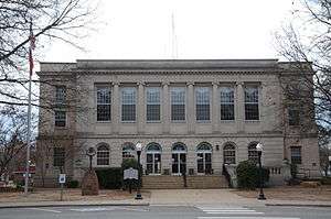 Courthouse in Clarksville | |
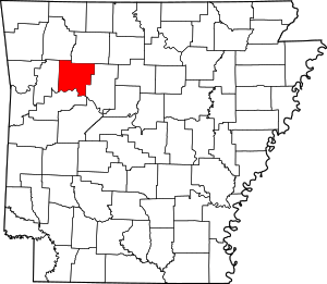 Location within the U.S. state of Arkansas | |
 Arkansas's location within the U.S. | |
| Coordinates: 35°33′00″N 93°28′00″W | |
| Country | |
| State | |
| Founded | November 16, 1833 |
| Seat | Clarksville |
| Largest city | Clarksville |
| Area | |
| • Total | 683 sq mi (1,770 km2) |
| • Land | 660 sq mi (1,700 km2) |
| • Water | 23 sq mi (60 km2) 3.4%% |
| Population (2010) | |
| • Total | 25,540 |
| • Estimate (2019) | 26,578 |
| • Density | 37/sq mi (14/km2) |
| Time zone | UTC−6 (Central) |
| • Summer (DST) | UTC−5 (CDT) |
| Congressional district | 4th |
| Website | johnsoncounty |
The Ada Mills Bridge links the Arkansas River between Johnson and Logan counties. It is named for Ada Mills, a former Republican political activist who lobbied for the structure for forty years before its completion.[4]
The notorious bandit Bill Doolin, the founder of the Wild Bunch, was born in Johnson County in 1858 and shot to death on capture in Oklahoma in 1896.
Geography
According to the U.S. Census Bureau, the county has a total area of 683 square miles (1,770 km2), of which 660 square miles (1,700 km2) is land and 23 square miles (60 km2) (3.4%) is water.[5]
Major highways
.svg.png)


Adjacent counties
- Newton County (north)
- Pope County (east)
- Logan County (south)
- Franklin County (west)
- Madison County (northwest)
National protected area
- Ozark National Forest (part)
Demographics
| Historical population | |||
|---|---|---|---|
| Census | Pop. | %± | |
| 1840 | 3,433 | — | |
| 1850 | 5,227 | 52.3% | |
| 1860 | 7,612 | 45.6% | |
| 1870 | 9,152 | 20.2% | |
| 1880 | 11,565 | 26.4% | |
| 1890 | 16,758 | 44.9% | |
| 1900 | 17,448 | 4.1% | |
| 1910 | 19,698 | 12.9% | |
| 1920 | 21,062 | 6.9% | |
| 1930 | 19,289 | −8.4% | |
| 1940 | 18,795 | −2.6% | |
| 1950 | 16,138 | −14.1% | |
| 1960 | 12,421 | −23.0% | |
| 1970 | 13,630 | 9.7% | |
| 1980 | 17,423 | 27.8% | |
| 1990 | 18,221 | 4.6% | |
| 2000 | 22,781 | 25.0% | |
| 2010 | 25,540 | 12.1% | |
| Est. 2019 | 26,578 | [6] | 4.1% |
| U.S. Decennial Census[7] 1790–1960[8] 1900–1990[9] 1990–2000[10] 2010–2016[1] | |||

As of the 2000 census,[12] there were 22,781 people, 8,738 households, and 6,238 families residing in the county. The population density was 34 people per square mile (13/km²). There were 9,926 housing units at an average density of 15 per square mile (6/km²). The racial makeup of the county was 93.69% White, 1.37% Black or African American, 0.62% Native American, 0.25% Asian, 0.01% Pacific Islander, 2.62% from other races, and 1.43% from two or more races. 6.70% of the population were Hispanic or Latino of any race.
There were 8,738 households out of which 32.40% had children under the age of 18 living with them, 58.10% were married couples living together, 9.50% had a female householder with no husband present, and 28.60% were non-families. 24.60% of all households were made up of individuals and 11.60% had someone living alone who was 65 years of age or older. The average household size was 2.54 and the average family size was 3.01.
In the county, the population was spread out with 25.20% under the age of 18, 9.70% from 18 to 24, 27.60% from 25 to 44, 22.70% from 45 to 64, and 14.80% who were 65 years of age or older. The median age was 36 years. For every 100 females there were 99.00 males. For every 100 females age 18 and over, there were 95.40 males.
The median income for a household in the county was $27,910, and the median income for a family was $33,630. Males had a median income of $25,779 versus $19,924 for females. The per capita income for the county was $15,097. About 12.90% of families and 16.40% of the population were below the poverty line, including 19.60% of those under age 18 and 15.30% of those age 65 or over.
Government
Politics
Over the past few election cycles Johnson County has trended heavily towards the GOP. The last Democrat to carry this county was Arkansas native Bill Clinton in 1996.
| Year | GOP | Dem | Others |
|---|---|---|---|
| 2016 | 66.85% 6,091 | 26.64% 2,427 | 6.52% 594 |
| 2012 | 62.53% 5,064 | 34.56% 2,799 | 2.90% 235 |
| 2008 | 60.17% 4,922 | 37.09% 3,034 | 2.74% 224 |
| 2004 | 53.59% 4,311 | 45.03% 3,622 | 1.38% 111 |
| 2000 | 51.07% 3,657 | 45.66% 3,270 | 3.27% 234 |
| 1996 | 34.64% 2,367 | 52.47% 3,585 | 12.89% 881 |
| 1992 | 33.82% 2,563 | 52.14% 3,951 | 14.04% 1,064 |
| 1988 | 58.29% 4,046 | 40.60% 2,818 | 1.11% 77 |
| 1984 | 60.30% 4,720 | 39.04% 3,056 | 0.65% 51 |
| 1980 | 47.39% 3,619 | 48.57% 3,709 | 4.03% 308 |
| 1976 | 30.11% 2,173 | 69.89% 5,044 | |
| 1972 | 66.76% 4,107 | 33.24% 2,045 | 0.00% 0 |
| 1968 | 32.64% 1,667 | 34.21% 1,747 | 33.15% 1,693 |
| 1964 | 32.78% 1,535 | 66.77% 3,127 | 0.45% 21 |
| 1960 | 42.29% 1,490 | 55.01% 1,938 | 2.70% 95 |
| 1956 | 46.84% 1,520 | 52.30% 1,697 | 0.86% 28 |
| 1952 | 45.90% 1,728 | 53.68% 2,021 | 0.42% 16 |
| 1948 | 23.25% 523 | 69.59% 1,565 | 7.16% 161 |
| 1944 | 31.03% 593 | 68.60% 1,311 | 0.37% 7 |
| 1940 | 18.11% 318 | 81.38% 1,429 | 0.51% 9 |
| 1936 | 17.95% 318 | 80.81% 1,432 | 1.24% 22 |
| 1932 | 14.88% 284 | 81.60% 1,557 | 3.51% 67 |
| 1928 | 36.93% 766 | 62.30% 1,292 | 0.77% 16 |
| 1924 | 19.78% 311 | 65.46% 1,029 | 14.76% 232 |
| 1920 | 36.15% 996 | 57.31% 1,579 | 6.53% 180 |
| 1916 | 27.85% 571 | 72.15% 1,479 | 0.00% 0 |
| 1912 | 12.57% 189 | 61.64% 927 | 25.80% 388 |
| 1908 | 29.14% 544 | 62.35% 1,164 | 8.52% 159 |
| 1904 | 31.30% 507 | 64.63% 1,047 | 4.07% 66 |
| 1900 | 29.30% 552 | 69.90% 1,317 | 0.80% 15 |
| 1896 | 21.06% 491 | 78.55% 1,831 | 0.39% 9 |
Cities
- Clarksville (county seat)
- Coal Hill
- Hartman
- Knoxville
- Lamar
Unincorporated communities
Census-designated place
Townships
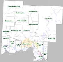
Townships in Arkansas are the divisions of a county. Each township includes unincorporated areas; some may have incorporated cities or towns within part of their boundaries. Arkansas townships have limited purposes in modern times. However, the United States Census does list Arkansas population based on townships (sometimes referred to as "county subdivisions" or "minor civil divisions"). Townships are also of value for historical purposes in terms of genealogical research. Each town or city is within one or more townships in an Arkansas county based on census maps and publications. The townships of Johnson County are listed below; listed in parentheses are the cities, towns, and/or census-designated places that are fully or partially inside the township. [14][15]
- Batson
- Dickerson-Hill
- Grant (Coal Hill)
- Hickey
- Horsehead
- Howell (most of Knoxville)
- Lee
- Low Gap
- McKennon
- Mulberry
- Perry (CDP Hagarville)
- Pittsburg (most of Lamar, small part of Knoxville)
- Prairie (small part of Clarksville)
- Red Lick
- Sherman
- Spadra (most of Clarksville, small part of Lamar)
- Stonewall
- Ward (Hartman)
See also
- List of lakes in Johnson County, Arkansas
- National Register of Historic Places listings in Johnson County, Arkansas
References
- "State & County QuickFacts". United States Census Bureau. Archived from the original on June 7, 2011. Retrieved May 22, 2014.
- "Find a County". National Association of Counties. Archived from the original on 2015-05-09. Retrieved 2011-06-07.
- Gannett, Henry (1905). The Origin of Certain Place Names in the United States. Govt. Print. Off. pp. 169.
- "Ada Mills". The Johnson County (Arkansas) Graphic, October 2001. Archived from the original on December 1, 2010. Retrieved September 8, 2010.
- "2010 Census Gazetteer Files". United States Census Bureau. August 22, 2012. Retrieved August 26, 2015.
- "Population and Housing Unit Estimates". Retrieved September 28, 2019.
- "U.S. Decennial Census". United States Census Bureau. Retrieved August 26, 2015.
- "Historical Census Browser". University of Virginia Library. Retrieved August 26, 2015.
- Forstall, Richard L., ed. (March 27, 1995). "Population of Counties by Decennial Census: 1900 to 1990". United States Census Bureau. Retrieved August 26, 2015.
- "Census 2000 PHC-T-4. Ranking Tables for Counties: 1990 and 2000" (PDF). United States Census Bureau. April 2, 2001. Retrieved August 26, 2015.
- Based on 2000 census data
- "U.S. Census website". United States Census Bureau. Retrieved 2011-05-14.
- "Dave Leip's Atlas of U.S. Presidential Elections". Retrieved November 18, 2016.
- 2011 Boundary and Annexation Survey (BAS): Johnson County, AR (PDF) (Map). U. S. Census Bureau. Archived from the original (PDF) on 2012-10-19. Retrieved 2011-08-18.
- "Arkansas: 2010 Census Block Maps - County Subdivision". United States Census Bureau. Archived from the original on May 28, 2014. Retrieved May 29, 2014.
Places adjacent to Johnson County, Arkansas | ||||||||||
|---|---|---|---|---|---|---|---|---|---|---|
| ||||||||||
Municipalities and communities of Johnson County, Arkansas, United States | ||
|---|---|---|
| Cities | Map of Arkansas highlighting Johnson County | |
| Town | ||
| CDP | ||
| Unincorporated communities | ||

| Authority control |
|
|---|