Clay County, Arkansas
Clay County is a county located in the U.S. state of Arkansas. As of the 2010 census, the population was 16,083.[1] The county has two county seats, Corning and Piggott.[2] It is a dry county, in which the sale of alcoholic beverages is restricted or prohibited.
Clay County | |
|---|---|
 | |
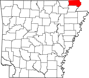 Location within the U.S. state of Arkansas | |
 Arkansas's location within the U.S. | |
| Coordinates: 36°22′39″N 90°26′07″W | |
| Country | |
| State | |
| Founded | March 24, 1873 |
| Seat | Corning (western district); Piggott (eastern district) |
| Largest city | Piggott |
| Area | |
| • Total | 641 sq mi (1,660 km2) |
| • Land | 639 sq mi (1,660 km2) |
| • Water | 2.0 sq mi (5 km2) 0.3%% |
| Population (2010) | |
| • Total | 16,083 |
| • Estimate (2019) | 14,551 |
| • Density | 25/sq mi (9.7/km2) |
| Time zone | UTC−6 (Central) |
| • Summer (DST) | UTC−5 (CDT) |
| Congressional district | 1st |
| Website | claycounty |
History
When Clay County was created as Arkansas's 67th county on March 24, 1873 (along with Baxter County), it was named Clayton County, after John M. Clayton, then a member of the Arkansas Senate and a brother of then-U.S. Senator Powell Clayton,[3] though some sources suggest it may have been named for Powell Clayton instead.[4]
Two years later on December 6, 1875,[5] the county's name was shortened to "Clay" by the Arkansas General Assembly. Some claim it was renamed for the statesman Henry Clay,[3][4] while others say John M. Clayton remained its official namesake.[6] The name change apparently was inspired by lingering distrust of Powell Clayton, as he had declared martial law and suspended elections in the county in 1868 when he was Governor of Arkansas and it was still part of Greene County.[3]
The first county seat was Corning,[7] established in 1873, with the arrival of the St. Louis, Iron Mountain and Southern Railway, as the first incorporated town in the county. The county seat was moved to Boydsville in 1877, in what was known as “Old Bradshaw Field”, because people living east of the Black and Cache Rivers had difficulty getting to Corning during the flood season. However, this caused problems for those living west of the rivers, and in 1881 Corning was re-established as the seat of the Western District, with Boydsville remaining the seat for the Eastern District. With the arrival of the St. Louis, Arkansas and Texas Railroad in 1882, other towns such as Greenway, Rector and Piggott experienced growth. In 1887, the Eastern District seat was moved to Piggott, and the dual county seat system remains in place today.[8] Important county functions (such as the Quorum Court) alternate between Piggott and Corning as their venues.
In the early 20th century, Clay, Greene, and Craighead counties had sundown town policies forbidding African Americans from living in the area.[9]
On April 6, 1972, Sheriff Douglas Batey and deputies Glen Ray Archer and Troy Key were shot and killed while trying to serve a warrant on Bert Grissom. Grissom opened fire as soon as the men stepped out of their car. He later surrendered without resistance to another deputy, and was tried, convicted, and sentenced to life in prison. William Thomas Pond became sheriff, but he died in an automobile accident on June 8, 1973. Four of the five police officers who have lost their lives serving the Clay County Sheriff's Office died in these two incidents.
Geography
According to the U.S. Census Bureau, the county has a total area of 641 square miles (1,660 km2), of which 639 square miles (1,660 km2) is land and 2.0 square miles (5.2 km2) (0.3%) is water.[10]
Major highways
.svg.png)
.svg.png)
.svg.png)
.svg.png)


Adjacent counties
- Butler County, Missouri (north)
- Dunklin County, Missouri (east)
- Greene County (south)
- Randolph County (west)
- Ripley County, Missouri (northwest)
Demographics
| Historical population | |||
|---|---|---|---|
| Census | Pop. | %± | |
| 1880 | 7,213 | — | |
| 1890 | 12,200 | 69.1% | |
| 1900 | 15,886 | 30.2% | |
| 1910 | 23,690 | 49.1% | |
| 1920 | 27,276 | 15.1% | |
| 1930 | 27,278 | 0.0% | |
| 1940 | 28,386 | 4.1% | |
| 1950 | 26,674 | −6.0% | |
| 1960 | 21,258 | −20.3% | |
| 1970 | 18,771 | −11.7% | |
| 1980 | 20,616 | 9.8% | |
| 1990 | 18,107 | −12.2% | |
| 2000 | 17,609 | −2.8% | |
| 2010 | 16,083 | −8.7% | |
| Est. 2019 | 14,551 | [11] | −9.5% |
| U.S. Decennial Census[12] 1790–1960[13] 1900–1990[14] 1990–2000[15] 2010–2016[1] | |||
As of the 2000 census,[17] there were 17,609 people, 7,417 households, and 5,073 families residing in the county. The population density was 28 people per square mile (11/km²). There were 8,498 housing units at an average density of 13 per square mile (5/km²). The racial makeup of the county was 98.08% White, 0.19% Black or African American, 0.69% Native American, 0.08% Asian, 0.15% from other races, and 0.81% from two or more races. 0.80% of the population were Hispanic or Latino of any race.
There were 7,417 households out of which 28.30% had children under the age of 18 living with them, 56.60% were married couples living together, 8.60% had a female householder with no husband present, and 31.60% were non-families. 28.40% of all households were made up of individuals and 16.70% had someone living alone who was 65 years of age or older. The average household size was 2.35 and the average family size was 2.87.
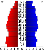
In the county, the population was spread out with 23.10% under the age of 18, 7.70% from 18 to 24, 25.30% from 25 to 44, 24.60% from 45 to 64, and 19.40% who were 65 years of age or older. The median age was 40 years. For every 100 females there were 93.50 males. For every 100 females age 18 and over, there were 88.30 males.
The median income for a household in the county was $25,345, and the median income for a family was $32,558. Males had a median income of $24,375 versus $17,146 for females. The per capita income for the county was $14,512. About 13.40% of families and 17.50% of the population were below the poverty line, including 21.20% of those under age 18 and 22.70% of those age 65 or over.
Government
County officials
- County Judge: Mike Patterson
- County Clerk: Pat Poole
- Sheriff & Collector: Terry Miller
- Circuit Clerk: Janet Kilbreath
- County Treasurer: Carolyn Morrisett
- District Judge: David Copelin
- Quorum Court Justices: David Cagle, Greg Ahrendt, Doyne Holifield, Joey Henderson, David Hatcher, Dennis Haynes, Mark Watson, & Burton Eddington, Jeff Douglas.
Politics
Over The past few election cycles Clay County has trended heavily towards the GOP. The last democrat (as of 2016) to carry this county was John Kerry in 2004.
| Year | GOP | Dem | Others |
|---|---|---|---|
| 2016 | 72.71% 3,781 | 23.06% 1,199 | 4.23% 220 |
| 2012 | 63.11% 3,225 | 34.01% 1,738 | 2.88% 147 |
| 2008 | 55.02% 3,032 | 40.72% 2,244 | 4.26% 235 |
| 2004 | 45.26% 2,759 | 53.54% 3,264 | 1.20% 73 |
| 2000 | 38.20% 2,254 | 59.78% 3,527 | 2.02% 119 |
| 1996 | 25.79% 1,512 | 65.63% 3,848 | 8.58% 503 |
| 1992 | 23.26% 1,647 | 68.47% 4,848 | 8.26% 585 |
| 1988 | 44.33% 2,766 | 55.16% 3,442 | 0.51% 32 |
| 1984 | 53.02% 3,767 | 46.15% 3,279 | 0.83% 59 |
| 1980 | 42.17% 3,091 | 54.37% 3,985 | 3.46% 254 |
| 1976 | 25.05% 1,893 | 74.95% 5,664 | |
| 1972 | 69.39% 4,381 | 30.61% 1,933 | 0.00% 0 |
| 1968 | 37.91% 2,410 | 26.16% 1,663 | 35.94% 2,285 |
| 1964 | 37.57% 1,999 | 61.64% 3,280 | 0.79% 42 |
| 1960 | 55.67% 2,543 | 41.77% 1,908 | 2.56% 117 |
| 1956 | 41.60% 1,711 | 57.57% 2,368 | 0.83% 34 |
| 1952 | 47.75% 2,105 | 51.66% 2,277 | 0.59% 26 |
| 1948 | 28.41% 878 | 66.94% 2,069 | 4.66% 144 |
| 1944 | 42.31% 1,422 | 57.54% 1,934 | 0.15% 5 |
| 1940 | 37.03% 1,029 | 60.31% 1,676 | 2.66% 74 |
| 1936 | 30.83% 795 | 68.94% 1,778 | 0.23% 6 |
| 1932 | 17.22% 397 | 82.00% 1,891 | 0.78% 18 |
| 1928 | 46.31% 1,254 | 52.99% 1,435 | 0.70% 19 |
| 1924 | 39.85% 1,084 | 52.54% 1,429 | 7.61% 207 |
| 1920 | 43.99% 1,536 | 50.83% 1,775 | 5.18% 181 |
| 1916 | 33.29% 973 | 66.71% 1,950 | 0.00% 0 |
| 1912 | 24.91% 622 | 52.02% 1,299 | 23.07% 576 |
| 1908 | 38.08% 1,009 | 57.62% 1,527 | 4.30% 114 |
| 1904 | 42.03% 752 | 54.11% 968 | 3.86% 69 |
| 1900 | 34.15% 627 | 65.09% 1,195 | 0.76% 14 |
| 1896 | 23.35% 475 | 75.57% 1,537 | 1.08% 22 |
Economy
Agriculture is the cornerstone of Clay County's economy. Farmers throughout the county grow a wide variety of crops. Rice is the dominant crop, but significant amounts of cotton, soybeans, corn, hay, and milo are also grown. Industry is limited to a handful of factories located in the cities of Piggott, Corning, and Rector.
Education
Public education of elementary and secondary school students is provided by:
Communities
Cities
- Corning (county seat)
- Greenway
- Knobel
- Peach Orchard
- Piggott (county seat)
- Pollard
- Rector
- St. Francis
Unincorporated community
Townships
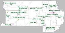
Townships in Arkansas are the divisions of a county. Each township includes unincorporated areas; some may have incorporated cities or towns within part of their boundaries. Arkansas townships have limited purposes in modern times. However, the United States Census does list Arkansas population based on townships (sometimes referred to as "county subdivisions" or "minor civil divisions"). Townships are also of value for historical purposes in terms of genealogical research. Each town or city is within one or more townships in an Arkansas county based on census maps and publications. The townships of Clay County are listed below; listed in parentheses are the cities, towns, and/or census-designated places that are fully or partially inside the township. [20][21]
- Bennett-Lemmons (McDougal)
- Bradshaw-Haywood (Greenway)
- Brown-Carpenter (Success)
- Cache-Wilson (Knobel)
- Chalk Bluff-Liddell (part of St. Francis)
- Clark (Peach Orchard)
- Cleveland-North Kilgore (part of Corning)
- East Oak Bluff-Blue Cane (part of Rector)
- Gleghorn-South Kilgore (part of Corning)
- Johnson
- Knob
- Nelson (Datto)
- North St. Francis (part of Piggott)
- Payne-Swain (Nimmons)
- Pollard (Pollard)
- South St. Francis (part of Piggott)
- West Oak Bluff (part of Rector)
See also
- Battle of Chalk Bluff
- List of lakes in Clay County, Arkansas
- National Register of Historic Places listings in Clay County, Arkansas
References
- "State & County & pie QuickFacts". United States Census Bureau. Archived from the original on July 8, 2011. Retrieved May 20, 2014.
- "Find a County". National Association of Counties. Archived from the original on 2011-05-31. Retrieved 2011-06-07.
- Clay County (Encyclopedia of Arkansas)
- Brief History of Clay County, Arkansas (CouchGenWeb.com) Archived 2010-10-28 at the Wayback Machine
- Stout, Scot (2012-03-07). "Early History of the County Seats and Courthouses of Clay County, Arkansas". ARGenWeb: Arkansas Genealogy Resources Online. The ARGenWeb Project. Retrieved 2012-05-08.
- Clay County (Local.Arkansas.gov) ("Senator James M. Clayton", probably referring to John M. Clayton)
- http://www.argenweb.net/clay/
- Rector Waterworks Building. "Archived copy". Archived from the original on 2014-07-28. Retrieved 2013-05-23.CS1 maint: archived copy as title (link), Retrieved on May 23, 2013.
- Neville, A. W. (March 2, 1945). "Backward Glances". The Paris News. Paris, Texas. p. 4 – via Newspapers.com.
On the survey from Bird's Point, Mo., to Jonesboro, Ark., I had a Negro cook. As Negroes were not allowed to live in Clay, Greene and Craighead Counties, Ark., my cook was a curiosity to the children. The women used to bring the children to camp to see him.
- "2010 Census Gazetteer Files". United States Census Bureau. August 22, 2012. Retrieved August 25, 2015.
- "Population and Housing Unit Estimates". Retrieved September 28, 2019.
- "U.S. Decennial Census". United States Census Bureau. Retrieved August 25, 2015.
- "Historical Census Browser". University of Virginia Library. Retrieved August 25, 2015.
- Forstall, Richard L., ed. (March 27, 1995). "Population of Counties by Decennial Census: 1900 to 1990". United States Census Bureau. Retrieved August 25, 2015.
- "Census 2000 PHC-T-4. Ranking Tables for Counties: 1990 and 2000" (PDF). United States Census Bureau. April 2, 2001. Retrieved August 25, 2015.
- Based on 2000 census data
- "U.S. Census website". United States Census Bureau. Retrieved 2011-05-14.
- "Dave Leip's Atlas of U.S. Presidential Elections". Retrieved November 18, 2016.
- https://ualr.edu/aedi/census-state-data-center/arkansas-census-data/
- 2011 Boundary and Annexation Survey (BAS): Clay County, AR (PDF) (Map). U. S. Census Bureau. Archived from the original (PDF) on 2012-10-19. Retrieved 2011-08-06.
- "Arkansas: 2010 Census Block Maps - County Subdivision". United States Census Bureau. Retrieved May 27, 2014.
Places adjacent to Clay County, Arkansas | ||||||||||
|---|---|---|---|---|---|---|---|---|---|---|
| ||||||||||
Municipalities and communities of Clay County, Arkansas, United States | ||
|---|---|---|
| Cities | Map of Arkansas highlighting Clay County | |
| Towns | ||
| Unincorporated communities | ||
| Ghost town | ||
| Footnotes | ‡This populated place also has portions in an adjacent county or counties | |

| Authority control |
|
|---|