Lonoke County, Arkansas
Lonoke County is a county located in the Central Arkansas region of the U.S. state of Arkansas. As of the 2010 census, the population was 68,356, making it the eleventh-most populous of Arkansas's seventy-five counties.[1] The county seat is Lonoke and largest city is Cabot.[2] Lonoke County was formed on April 16, 1873 from Pulaski County and Prairie County, and was named as a corruption of "lone oak", after a large red oak in the area that had been used by a surveyor to lay out the Memphis and Little Rock Railroad.
Lonoke County | |
|---|---|
| County of Lonoke | |
 | |
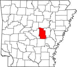 Location within the U.S. state of Arkansas | |
 Arkansas's location within the U.S. | |
| Coordinates: 34°46′41″N 91°52′18″W | |
| Country | |
| State | |
| Founded | April 16, 1874 |
| Seat | Lonoke |
| Largest city | Cabot |
| Area | |
| • Total | 803 sq mi (2,080 km2) |
| • Land | 771 sq mi (2,000 km2) |
| • Water | 32 sq mi (80 km2) 4.0%% |
| Population (2010) | |
| • Total | 68,356 |
| • Estimate (2019) | 73,309 |
| • Density | 85/sq mi (33/km2) |
| Time zone | UTC−6 (Central) |
| • Summer (DST) | UTC−5 (CDT) |
| Congressional district | 1st |
Located within Central Arkansas, the county's varied geography can be roughly broken into thirds horizontally. The top third has rolling hills at the edge of the Ozarks, including the Cabot area. The middle third, including the Lonoke area, contains portions of the Grand Prairie, a flat native grassland today known for rice farming, an important part of the culture, economy and history of Lonoke County. The southern third, including the Scott area, is home to the alluvial soils of the Arkansas Delta. Historically, a military road and a railroad brought settlers to the area, and cotton cultivation was very profitable. In 1904, a demonstration that rice could grow well on the same land coupled with sinking cotton prices drove the area into rice cultivation. During World War I, a United States Army World War I Flight Training airfield, Eberts Field, was constructed.
Lonoke County is included in the Central Arkansas metro area, with Little Rock as the principal city. In addition to agriculture, the county's economy sees tourists at the Camp Nelson Confederate Cemetery, Joe Hogan Fish Hatchery and Toltec Mounds State Park, Lonoke County is an alcohol prohibition or dry county.
Geography
According to the U.S. Census Bureau, the county has a total area of 803 square miles (2,080 km2), of which 771 square miles (2,000 km2) is land and 32 square miles (83 km2) (4.0%) is water.[3]
State Nature
Toltec Mounds Plantation Agri. Mus. State Park Bayou Meto
Major highways
.svg.png)
.svg.png)


Adjacent counties
- White County (north)
- Prairie County (east)
- Arkansas County (southeast)
- Jefferson County (south)
- Pulaski County (west)
- Faulkner County (northwest)
Demographics
| Historical population | |||
|---|---|---|---|
| Census | Pop. | %± | |
| 1880 | 12,146 | — | |
| 1890 | 19,263 | 58.6% | |
| 1900 | 22,544 | 17.0% | |
| 1910 | 27,983 | 24.1% | |
| 1920 | 33,400 | 19.4% | |
| 1930 | 33,759 | 1.1% | |
| 1940 | 29,802 | −11.7% | |
| 1950 | 27,278 | −8.5% | |
| 1960 | 24,551 | −10.0% | |
| 1970 | 26,249 | 6.9% | |
| 1980 | 34,518 | 31.5% | |
| 1990 | 39,268 | 13.8% | |
| 2000 | 52,828 | 34.5% | |
| 2010 | 68,356 | 29.4% | |
| Est. 2019 | 73,309 | [4] | 7.2% |
| U.S. Decennial Census[5] 1790–1960[6] 1900–1990[7] 1990–2000[8] 2010–2016[1] | |||
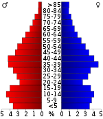
As of the 2000 census,[10] there were 52,828 people, 19,262 households, and 15,024 families residing in the county. The population density was 69 people per square mile (27/km2). There were 20,749 housing units at an average density of 27 per square mile (10/km2). The racial makeup of the county was 91.03% White, 6.44% Black or African American, 0.49% Native American, 0.42% Asian, 0.03% Pacific Islander, 0.51% from other races, and 1.08% from two or more races. 1.75% of the population were Hispanic or Latino of any race.
There were 19,262 households, out of which 40.30% had children under the age of 18 living with them, 63.30% were married couples living together, 10.60% had a female householder with no husband present, and 22.00% were non-families. 19.00% of all households were made up of individuals, and 7.60% had someone living alone who was 65 years of age or older. The average household size was 2.71 and the average family size was 3.09.
In the county, the population was spread out, with 28.70% under the age of 18, 8.00% from 18 to 24, 30.90% from 25 to 44, 21.90% from 45 to 64, and 10.40% who were 65 years of age or older. The median age was 35 years. For every 100 females, there were 96.80 males. For every 100 females age 18 and over, there were 93.50 males.
The median income for a household in the county was $40,314, and the median income for a family was $46,173. Males had a median income of $32,451 versus $22,897 for females. The per capita income for the county was $17,397. About 8.10% of families and 10.50% of the population were below the poverty line, including 12.20% of those under age 18 and 13.60% of those age 65 or over.
Government
Over the past few election cycles, Lonoke County has trended heavily towards the Republican party. The last Democrat (as of 2016) to carry the county was Bill Clinton in 1996.
| Year | GOP | Dem | Others |
|---|---|---|---|
| 2016 | 73.65% 19,958 | 20.90% 5,664 | 5.46% 1,478 |
| 2012 | 74.15% 17,880 | 23.33% 5,625 | 2.53% 609 |
| 2008 | 72.63% 17,242 | 25.14% 5,968 | 2.24% 531 |
| 2004 | 65.36% 14,398 | 33.84% 7,454 | 0.81% 178 |
| 2000 | 59.11% 10,606 | 38.18% 6,851 | 2.71% 486 |
| 1996 | 39.95% 6,414 | 50.13% 8,049 | 9.93% 1,593 |
| 1992 | 39.52% 6,253 | 50.32% 7,963 | 10.16% 1,608 |
| 1988 | 59.68% 7,215 | 39.59% 4,786 | 0.74% 89 |
| 1984 | 64.11% 8,425 | 35.28% 4,636 | 0.62% 81 |
| 1980 | 48.50% 5,619 | 48.38% 5,605 | 3.11% 361 |
| 1976 | 24.49% 2,522 | 75.36% 7,761 | 0.16% 16 |
| 1972 | 67.62% 5,298 | 31.96% 2,504 | 0.42% 33 |
| 1968 | 21.80% 1,677 | 26.18% 2,014 | 52.02% 4,002 |
| 1964 | 48.63% 3,636 | 51.06% 3,818 | 0.31% 23 |
| 1960 | 29.17% 1,560 | 55.93% 2,991 | 14.90% 797 |
| 1956 | 36.21% 1,932 | 60.61% 3,234 | 3.19% 170 |
| 1952 | 30.82% 1,570 | 69.04% 3,517 | 0.14% 7 |
| 1948 | 12.81% 383 | 69.04% 2,065 | 18.16% 543 |
| 1944 | 25.23% 697 | 74.70% 2,064 | 0.07% 2 |
| 1940 | 14.52% 323 | 85.35% 1,899 | 0.13% 3 |
| 1936 | 10.17% 310 | 89.76% 2,735 | 0.07% 2 |
| 1932 | 5.58% 175 | 94.04% 2,951 | 0.38% 12 |
| 1928 | 26.66% 676 | 73.23% 1,857 | 0.12% 3 |
| 1924 | 23.87% 321 | 71.52% 962 | 4.61% 62 |
| 1920 | 28.09% 697 | 68.96% 1,711 | 2.94% 73 |
| 1916 | 19.11% 515 | 80.89% 2,180 | 0.00% 0 |
| 1912 | 13.52% 254 | 60.09% 1,129 | 26.40% 496 |
| 1908 | 28.78% 592 | 67.33% 1,385 | 3.89% 80 |
| 1904 | 39.22% 775 | 59.62% 1,178 | 1.16% 23 |
| 1900 | 33.15% 679 | 65.28% 1,337 | 1.56% 32 |
| 1896 | 15.82% 437 | 83.27% 2,300 | 0.91% 25 |
Communities
Census-designated place
Townships
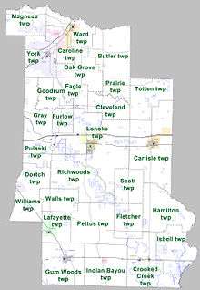
Townships in Arkansas are the divisions of a county. Each township includes unincorporated areas; some may have incorporated cities or towns within part of their boundaries. Arkansas townships have limited purposes in modern times. However, the United States Census does list Arkansas population based on townships (sometimes referred to as "county subdivisions" or "minor civil divisions"). Townships are also of value for historical purposes in terms of genealogical research. Each town or city is within one or more townships in an Arkansas county based on census maps and publications. The townships of Lonoke County are listed below; listed in parentheses are the cities, towns, and/or census-designated places that are fully or partially inside the township. [12][13]
- Butler
- Carlisle (Carlisle)
- Caroline (Austin, small part of Cabot, part of Ward)
- Cleveland
- Crooked Creek (Allport, Humnoke)
- Dortch (CDP Scott)
- Eagle
- Fletcher
- Furlow
- Goodrum
- Gray
- Gum Woods (England)
- Hamilton
- Indian Bayou (Coy)
- Isbell
- Lafayette (Keo)
- Lonoke (Lonoke)
- Magness (part of Cabot)
- Oak Grove (small part of Cabot)
- Pettus
- Prairie
- Pulaski
- Richwoods
- Scott
- Totten
- Walls
- Ward (part of Ward)
- Williams
- York (most of Cabot)
See also
- List of dry counties in Arkansas
- List of counties in Arkansas
- List of lakes in Lonoke County, Arkansas
- National Register of Historic Places listings in Lonoke County, Arkansas
References
- "State & County QuickFacts". United States Census Bureau. Archived from the original on June 7, 2011. Retrieved May 20, 2014.
- "Find a County". National Association of Counties. Retrieved 2011-06-07.
- "2010 Census Gazetteer Files". United States Census Bureau. August 22, 2012. Retrieved August 27, 2015.
- "Population and Housing Unit Estimates". Retrieved September 28, 2019.
- "U.S. Decennial Census". United States Census Bureau. Retrieved August 27, 2015.
- "Historical Census Browser". University of Virginia Library. Retrieved August 27, 2015.
- Forstall, Richard L., ed. (March 27, 1995). "Population of Counties by Decennial Census: 1900 to 1990". United States Census Bureau. Retrieved August 27, 2015.
- "Census 2000 PHC-T-4. Ranking Tables for Counties: 1990 and 2000" (PDF). United States Census Bureau. April 2, 2001. Retrieved August 27, 2015.
- Based on 2000 census data
- "U.S. Census website". United States Census Bureau. Retrieved 2011-05-14.
- "Dave Leip's Atlas of U.S. Presidential Elections". Retrieved November 18, 2016.
- 2011 Boundary and Annexation Survey (BAS): Lonoke County, AR (PDF) (Map). U. S. Census Bureau. Archived from the original (PDF) on 2012-10-19. Retrieved 2011-08-15.
- "Arkansas: 2010 Census Block Maps - County Subdivision". United States Census Bureau. Retrieved May 29, 2014.
External links
| Wikimedia Commons has media related to Lonoke County, Arkansas. |
Places adjacent to Lonoke County, Arkansas | ||||||||||
|---|---|---|---|---|---|---|---|---|---|---|
| ||||||||||
Municipalities and communities of Lonoke County, Arkansas, United States | ||
|---|---|---|
| Cities | Map of Arkansas highlighting Lonoke County | |
| Towns | ||
| CDP | ||
| Townships |
| |
| Unincorporated communities | ||
| Footnotes | ‡This populated place also has portions in an adjacent county or counties | |

| Authority control |
|
|---|