Sebastian County, Arkansas
Sebastian County is a county located in the U.S. state of Arkansas. As of the 2010 census, the population was 125,744,[1] making it the fourth-most populous county in Arkansas. The county has two county seats, Greenwood and Fort Smith.[2]
Sebastian County | |
|---|---|
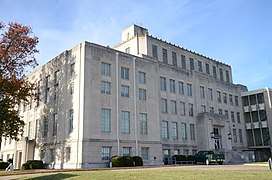 The Sebastian County Courthouse in Ft. Smith | |
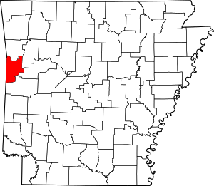 Location within the U.S. state of Arkansas | |
 Arkansas's location within the U.S. | |
| Coordinates: 35°35′39″N 94°15′29″W | |
| Country | |
| State | |
| Founded | January 6, 1851 |
| Named for | William K. Sebastian |
| Seat | Fort Smith (northern district); Greenwood (southern district) |
| Largest city | Fort Smith |
| Area | |
| • Total | 546 sq mi (1,410 km2) |
| • Land | 532 sq mi (1,380 km2) |
| • Water | 14 sq mi (40 km2) 2.6%% |
| Population (2010) | |
| • Total | 125,744 |
| • Estimate (2019) | 127,827 |
| • Density | 230/sq mi (89/km2) |
| Time zone | UTC−6 (Central) |
| • Summer (DST) | UTC−5 (CDT) |
| Congressional districts | 3rd, 4th |
| Website | www |
Sebastian County is part of the Fort Smith, AR-OK Metropolitan Statistical Area.
History
Sebastian County is Arkansas's 56th county, formed on January 6, 1851, and named for William K. Sebastian, United States Senator from Arkansas.[3]
Geography
According to the U.S. Census Bureau, the county has a total area of 546 square miles (1,410 km2), of which 532 square miles (1,380 km2) is land and 14 square miles (36 km2) (2.6%) is water.[4] It is the second-smallest county by area in Arkansas.
Major highways
_Metric.svg.png)
_Metric.svg.png)
.svg.png)
.svg.png)
.svg.png)


Adjacent counties
- Crawford County (north)
- Franklin County (east)
- Logan County (southeast)
- Scott County (south)
- Le Flore County, Oklahoma (southwest)
- Sequoyah County, Oklahoma (northwest)
National protected areas
- Fort Smith National Historic Site (part)
- Ouachita National Forest (part)
Demographics
| Historical population | |||
|---|---|---|---|
| Census | Pop. | %± | |
| 1860 | 9,238 | — | |
| 1870 | 12,940 | 40.1% | |
| 1880 | 19,560 | 51.2% | |
| 1890 | 33,200 | 69.7% | |
| 1900 | 36,935 | 11.3% | |
| 1910 | 52,278 | 41.5% | |
| 1920 | 56,739 | 8.5% | |
| 1930 | 54,426 | −4.1% | |
| 1940 | 62,809 | 15.4% | |
| 1950 | 64,202 | 2.2% | |
| 1960 | 66,685 | 3.9% | |
| 1970 | 79,237 | 18.8% | |
| 1980 | 95,172 | 20.1% | |
| 1990 | 99,590 | 4.6% | |
| 2000 | 115,071 | 15.5% | |
| 2010 | 125,744 | 9.3% | |
| Est. 2019 | 127,827 | [5] | 1.7% |
| U.S. Decennial Census[6] 1790–1960[7] 1900–1990[8] 1990–2000[9] 2010–2016[1] | |||
As of the 2000 United States Census,[11] there were 115,071 people, 45,300 households, and 30,713 families residing in the county. The population density was 215 people per square mile (83/km²). There were 49,311 housing units at an average density of 92 per square mile (36/km²). The racial makeup of the county was 82.34% White, 6.16% Black or African American, 1.57% Native American, 3.51% Asian, 0.05% Pacific Islander, 3.71% from other races, and 2.67% from two or more races. 6.70% of the population were Hispanic or Latino of any race. 19.6% were of American, 12.6% German, 11.0% Irish and 9.0% English ancestry according to Census 2000. 5.49% reported speaking Spanish at home, while 1.47% speak Vietnamese and 0.97% Lao.[12]
In 2000 there were 45,300 households out of which 32.80% had children under the age of 18 living with them, 52.40% were married couples living together, 11.30% had a female householder with no husband present, and 32.20% were non-families. 27.50% of all households were made up of individuals and 10.00% had someone living alone who was 65 years of age or older. The average household size was 2.49 and the average family size was 3.04.
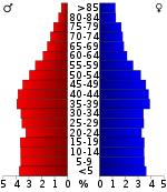
In the county, the population was spread out with 26.00% under the age of 18, 9.20% from 18 to 24, 29.50% from 25 to 44, 22.30% from 45 to 64, and 13.00% who were 65 years of age or older. The median age was 36 years. For every 100 females, there were 95.30 males. For every 100 females age 18 and over, there were 92.10 males.
The median income for a household in the county was $33,889, and the median income for a family was $41,303. Males had a median income of $30,056 versus $22,191 for females. The per capita income for the county was $18,424. About 10.40% of families and 13.60% of the population were below the poverty line, including 18.60% of those under age 18 and 10.00% of those age 65 or over.
As of 2010 census the population of Sebastian County was 125,744. The racial makeup of the county was 72.83% Non-Hispanic white, 6.24% Non-Hispanic black, 1.88% Native American, 4.06% Asian, 0.09% Pacific Islander, 0.07% Non-Hispanics of some other race, 2.78% Non-Hispanics reporting two or more races and 12.82% Hispanics.
Government
Politics
Whereas most of Arkansas was overwhelmingly blue up to the mid-2000s, Sebastian has been a solidly Republican county since Dwight Eisenhower won it in 1952. Since that election, no Democrat has ever again carried this county, though native son Bill Clinton came less than 300 votes of doing so in 1992.
| Year | GOP | Dem | Others |
|---|---|---|---|
| 2016 | 65.25% 29,127 | 27.56% 12,300 | 7.19% 3,210 |
| 2012 | 67.27% 29,169 | 30.19% 13,092 | 2.54% 1,101 |
| 2008 | 66.27% 28,637 | 31.64% 13,673 | 2.09% 902 |
| 2004 | 61.76% 27,303 | 37.27% 16,479 | 0.97% 429 |
| 2000 | 58.48% 23,483 | 38.73% 15,555 | 2.79% 1,121 |
| 1996 | 46.63% 16,482 | 43.89% 15,514 | 9.48% 3,350 |
| 1992 | 42.40% 16,817 | 41.78% 16,570 | 15.82% 6,272 |
| 1988 | 70.94% 24,426 | 28.13% 9,684 | 0.94% 322 |
| 1984 | 74.95% 27,595 | 23.60% 8,688 | 1.45% 534 |
| 1980 | 63.46% 23,403 | 27.50% 10,141 | 9.04% 3,335 |
| 1976 | 52.79% 17,671 | 47.11% 15,768 | 0.10% 34 |
| 1972 | 81.23% 25,219 | 18.58% 5,770 | 0.19% 58 |
| 1968 | 44.65% 12,073 | 23.37% 6,320 | 31.98% 8,649 |
| 1964 | 55.80% 13,110 | 43.84% 10,299 | 0.36% 84 |
| 1960 | 56.75% 11,744 | 42.16% 8,726 | 1.09% 226 |
| 1956 | 57.36% 10,234 | 41.98% 7,489 | 0.66% 118 |
| 1952 | 56.36% 10,114 | 43.48% 7,802 | 0.16% 28 |
| 1948 | 33.09% 2,928 | 57.36% 5,075 | 9.55% 845 |
| 1944 | 36.46% 3,452 | 63.46% 6,008 | 0.07% 7 |
| 1940 | 27.16% 1,968 | 72.44% 5,249 | 0.40% 29 |
| 1936 | 20.30% 1,161 | 79.35% 4,539 | 0.35% 20 |
| 1932 | 20.26% 1,268 | 78.87% 4,937 | 0.88% 55 |
| 1928 | 51.84% 3,465 | 47.67% 3,186 | 0.49% 33 |
| 1924 | 33.13% 1,985 | 52.54% 3,148 | 14.34% 859 |
| 1920 | 46.03% 3,492 | 50.78% 3,852 | 3.19% 242 |
| 1916 | 26.86% 1,366 | 73.14% 3,719 | 0.00% 0 |
| 1912 | 12.53% 514 | 58.40% 2,396 | 29.08% 1,193 |
| 1908 | 35.73% 2,050 | 52.90% 3,035 | 11.36% 652 |
| 1904 | 38.16% 1,254 | 50.06% 1,645 | 11.78% 387 |
| 1900 | 31.21% 964 | 67.79% 2,094 | 1.00% 31 |
| 1896 | 27.57% 1,009 | 71.64% 2,622 | 0.79% 29 |
Education
Public education is provided by several school districts (listed below from largest to smallest):
Communities
Cities
- Barling
- Bonanza
- Fort Smith (county seat)
- Greenwood (county seat)
- Hackett
- Hartford
- Huntington
- Lavaca
- Mansfield
Towns
Townships
Townships in Arkansas are the divisions of a county. Each township includes unincorporated areas; some may have incorporated cities or towns within part of their boundaries. Arkansas townships have limited purposes in modern times. However, the United States Census does list Arkansas population based on townships (sometimes referred to as "county subdivisions" or "minor civil divisions"). Townships are also of value for historical purposes in terms of genealogical research. Each town or city is within one or more townships in an Arkansas county based on census maps and publications. The townships of Sebastian County are listed below; listed in parentheses are the cities, towns, and/or census-designated places that are fully or partially inside the township. [14][15]
- Bass Little (some of Greenwood)
- Big Creek (Lavaca)
- Beverly
- Bloomer
- Center (most of Greenwood)
- Cole (Hackett)
- Dayton
- Diamond (Huntington)
- Fort Chafee UT (part of Barling, part of Fort Smith)
- Hartford (Hartford)
- Island
- Jim Fork (Midland)
- Lon Norris (part of Fort Smith)
- Marion (Bonanza, small part of Fort Smith)
- Mississippi
- Mont Sandels (Central City, most of Barling)
- Prairie
- Rogers
- Sugarloaf (part of Mansfield)
- Upper (most of Fort Smith)
- Washburn
- White Oak
Notable people
- John Sebastian Little, member of the United States House of Representatives and the 21st Governor of the U.S. state of Arkansas[16]
- Mathew Pitsch, Republican member of the Arkansas House of Representatives for Sebastian County[17]
See also
- List of lakes in Sebastian County, Arkansas
- National Register of Historic Places listings in Sebastian County, Arkansas
References
- "State & County QuickFacts". United States Census Bureau. Retrieved May 19, 2014.
- "Find a County". National Association of Counties. Retrieved 2011-06-07.
- "Profile for Sebastian County, Arkansas, AR". ePodunk. Retrieved August 17, 2012.
- "2010 Census Gazetteer Files". United States Census Bureau. August 22, 2012. Retrieved August 27, 2015.
- "County Population Totals and Components of Change: 2010-2018". United States Census Bureau. Retrieved June 2, 2019.
- "U.S. Decennial Census". United States Census Bureau. Retrieved August 27, 2015.
- "Historical Census Browser". University of Virginia Library. Retrieved August 27, 2015.
- Forstall, Richard L., ed. (March 27, 1995). "Population of Counties by Decennial Census: 1900 to 1990". United States Census Bureau. Retrieved August 27, 2015.
- "Census 2000 PHC-T-4. Ranking Tables for Counties: 1990 and 2000" (PDF). United States Census Bureau. April 2, 2001. Retrieved August 27, 2015.
- Based on 2000 census data
- "U.S. Census website". United States Census Bureau. Retrieved 2011-05-14.
- "Language Map Data Center". Mla.org. 2007-07-17. Retrieved 2012-11-15.
- "Dave Leip's Atlas of U.S. Presidential Elections". Retrieved November 18, 2016.
- 2011 Boundary and Annexation Survey (BAS): Sebastian County, AR (PDF) (Map). U. S. Census Bureau. Archived from the original (PDF) on 2012-10-19. Retrieved 2011-08-25.
- "Arkansas: 2010 Census Block Maps - County Subdivision". United States Census Bureau. Retrieved May 29, 2014.
- "Arkansas Governor John Sebastian Little". National Governors Association. Retrieved August 17, 2012.
- "Mathew W. Pitsch". arkansashouse.org. Retrieved April 10, 2015.
External links
- Sebastian County, Arkansas entry on the Encyclopedia of Arkansas History & Culture
- Sebastian County official website
Places adjacent to Sebastian County, Arkansas | ||||||||||
|---|---|---|---|---|---|---|---|---|---|---|
| ||||||||||
Municipalities and communities of Sebastian County, Arkansas, United States | ||
|---|---|---|
| Cities | Map of Arkansas highlighting Sebastian County | |
| Towns | ||
| Unincorporated communities | ||
| Footnotes | ‡This populated place also has portions in an adjacent county or counties | |

| Authority control |
|
|---|