Jackson County, Arkansas
Jackson County is located in the Arkansas Delta in the U.S. state of Arkansas. The county is named for Andrew Jackson, a national hero during the War of 1812. By the county's formation in 1829, Jackson had become the seventh President of the United States. Jackson County is home to seven incorporated towns and four incorporated cities, including Newport, the largest city and county seat. The county is also the site of numerous unincorporated communities and ghost towns. Occupying 633.94 square miles (164,190 ha), Jackson County is the 41st largest county of the 75 in Arkansas. As of the 2010 Census, the county's population is 17,997 people in 7,601 households.[1] Based on population, the county is the 40th-largest county in Arkansas.[2] Although terrain rises in the west, most of Jackson County is within the Arkansas Delta, characterized by largely flat terrain with fertile soils. Historically covered in forest, bayous and swamps, the area was cleared for agriculture by early settlers. It is drained by the White River.
Jackson County | |
|---|---|
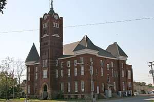 Jackson County Courthouse | |
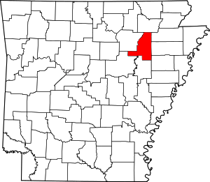 Location within the U.S. state of Arkansas | |
 Arkansas's location within the U.S. | |
| Coordinates: 35°35′38″N 91°11′37″W | |
| Country | |
| State | |
| Founded | November 5, 1829 |
| Named for | Andrew Jackson |
| Seat | Newport |
| Largest city | Newport |
| Area | |
| • Total | 642 sq mi (1,660 km2) |
| • Land | 634 sq mi (1,640 km2) |
| • Water | 7.6 sq mi (20 km2) 1.2%% |
| Population (2010) | |
| • Total | 17,997 |
| • Estimate (2019) | 16,719 |
| • Density | 28/sq mi (11/km2) |
| Time zone | UTC−6 (Central) |
| • Summer (DST) | UTC−5 (CDT) |
| Congressional district | 1st |
| Website | www |
Although no Interstate highways are located in Jackson County, two United States highways (U.S. Route 67 (US 67) and US 167) and fifteen Arkansas state highways run in the county. A Union Pacific Railroad line also crosses the county.[3]
Geography
According to the U.S. Census Bureau, the county has a total area of 642 square miles (1,660 km2), of which 634 square miles (1,640 km2) is land and 7.6 square miles (20 km2) (1.2%) is water.[4]
Major highways
.svg.png)
.svg.png)


.svg.png)
Adjacent counties
- Lawrence County (north)
- Craighead County (northeast)
- Poinsett County (east)
- Cross County (southeast)
- Woodruff County (south)
- White County (southwest)
- Independence County (west)
National protected area
Demographics
| Historical population | |||
|---|---|---|---|
| Census | Pop. | %± | |
| 1830 | 333 | — | |
| 1840 | 1,540 | 362.5% | |
| 1850 | 3,086 | 100.4% | |
| 1860 | 10,493 | 240.0% | |
| 1870 | 7,268 | −30.7% | |
| 1880 | 10,877 | 49.7% | |
| 1890 | 15,179 | 39.6% | |
| 1900 | 18,383 | 21.1% | |
| 1910 | 23,501 | 27.8% | |
| 1920 | 25,446 | 8.3% | |
| 1930 | 27,943 | 9.8% | |
| 1940 | 26,427 | −5.4% | |
| 1950 | 25,912 | −1.9% | |
| 1960 | 22,843 | −11.8% | |
| 1970 | 20,452 | −10.5% | |
| 1980 | 21,646 | 5.8% | |
| 1990 | 18,944 | −12.5% | |
| 2000 | 18,418 | −2.8% | |
| 2010 | 17,997 | −2.3% | |
| Est. 2019 | 16,719 | [5] | −7.1% |
| U.S. Decennial Census[6] 1790–1960[7] 1900–1990[8] 1990–2000[9] 2010–2016[10] | |||
As of the 2000 census,[12] there were 18,418 people, 6,971 households, and 4,830 families residing in the county. The population density was 29 people per square mile (11/km²). There were 7,956 housing units at an average density of 13 per square mile (5/km²). The racial makeup of the county was 80.57% White, 17.56% Black or African American, 0.33% Native American, 0.18% Asian, 0.01% Pacific Islander, 0.40% from other races, and 0.95% from two or more races. 1.27% of the population were Hispanic or Latino of any race.
There were 6,971 households out of which 27.70% had children under the age of 18 living with them, 52.20% were married couples living together, 13.10% had a female householder with no husband present, and 30.70% were non-families. 27.90% of all households were made up of individuals and 14.40% had someone living alone who was 65 years of age or older. The average household size was 2.40 and the average family size was 2.92.
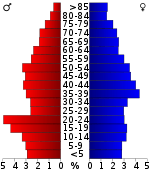
In the county, the population was spread out with 22.20% under the age of 18, 11.50% from 18 to 24, 26.00% from 25 to 44, 23.80% from 45 to 64, and 16.50% who were 65 years of age or older. The median age was 38 years. For every 100 females there were 91.20 males. For every 100 females age 18 and over, there were 87.80 males.
The median income for a household in the county was $25,081, and the median income for a family was $32,661. Males had a median income of $26,744 versus $17,830 for females. The per capita income for the county was $14,564. About 13.20% of families and 17.40% of the population were below the poverty line, including 25.00% of those under age 18 and 16.70% of those age 65 or over.
Government and infrastructure
The Grimes Unit and the McPherson Unit, prisons of the Arkansas Department of Correction, are located in Newport, off of Arkansas Highway 384, 4 miles (6.4 km) east of central Newport.[13] The prison houses the state’s death row for women.[14] The Jackson County Sheriff's Office is the primary county-wide law enforcement agency.
Politics
Over The past few election cycles Jackson county has trended heavily towards the GOP. The last democrat (as of 2016) to carry this county was John Kerry in 2004.
| Year | GOP | Dem | Others |
|---|---|---|---|
| 2016 | 63.36% 3,267 | 30.70% 1,583 | 5.93% 306 |
| 2012 | 57.45% 3,072 | 39.18% 2,095 | 3.37% 180 |
| 2008 | 55.86% 3,118 | 39.54% 2,207 | 4.60% 257 |
| 2004 | 42.19% 2,624 | 56.52% 3,515 | 1.29% 80 |
| 2000 | 37.55% 2,280 | 60.13% 3,651 | 2.32% 141 |
| 1996 | 23.46% 1,525 | 66.22% 4,304 | 10.32% 671 |
| 1992 | 24.77% 1,864 | 65.71% 4,944 | 9.51% 716 |
| 1988 | 41.90% 3,049 | 57.71% 4,199 | 0.38% 28 |
| 1984 | 48.88% 3,901 | 50.60% 4,038 | 0.53% 42 |
| 1980 | 39.49% 3,191 | 57.55% 4,651 | 2.95% 239 |
| 1976 | 21.64% 1,783 | 78.36% 6,456 | |
| 1972 | 66.73% 4,196 | 33.27% 2,092 | 0.00% 0 |
| 1968 | 19.56% 1,356 | 29.59% 2,051 | 50.85% 3,525 |
| 1964 | 31.36% 2,141 | 68.12% 4,651 | 0.53% 36 |
| 1960 | 38.50% 1,986 | 55.44% 2,860 | 6.07% 313 |
| 1956 | 26.14% 1,323 | 73.09% 3,699 | 0.77% 39 |
| 1952 | 25.62% 1,516 | 74.38% 4,401 | 0.00% 0 |
| 1948 | 10.34% 338 | 82.45% 2,696 | 7.22% 236 |
| 1944 | 15.15% 414 | 84.85% 2,318 | 0.00% 0 |
| 1940 | 14.54% 382 | 84.59% 2,223 | 0.88% 23 |
| 1936 | 13.19% 327 | 86.77% 2,151 | 0.04% 1 |
| 1932 | 7.09% 193 | 92.58% 2,521 | 0.33% 9 |
| 1928 | 31.24% 698 | 68.35% 1,527 | 0.40% 9 |
| 1924 | 25.44% 392 | 69.37% 1,069 | 5.19% 80 |
| 1920 | 40.34% 1,131 | 56.17% 1,575 | 3.50% 98 |
| 1916 | 26.05% 476 | 73.95% 1,351 | 0.00% 0 |
| 1912 | 31.94% 543 | 49.24% 837 | 18.82% 320 |
| 1908 | 42.39% 864 | 51.77% 1,055 | 5.84% 119 |
| 1904 | 47.28% 677 | 52.09% 746 | 0.63% 9 |
| 1900 | 36.05% 598 | 63.29% 1,050 | 0.66% 11 |
| 1896 | 26.95% 588 | 72.64% 1,585 | 0.41% 9 |
Communities
Towns
Unincorporated Communities
- Balch
- Centerville
- Denmark
- Heffington
- Kenyon
- Macks
- Midway
- Olyphant
- Possum Grape
Ghost towns
- Colerain
- Estico
- Mt. Pinson
- Myrickville
- Sneed
Townships
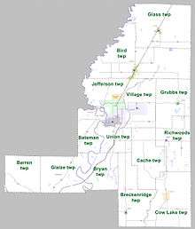
Townships in Arkansas are the divisions of a county. Each township includes unincorporated areas; some may have incorporated cities or towns within part of their boundaries. Arkansas townships have limited purposes in modern times. However, the United States Census does list Arkansas population based on townships (sometimes referred to as "county subdivisions" or "minor civil divisions"). Townships are also of value for historical purposes in terms of genealogical research. Each town or city is within one or more townships in an Arkansas county based on census maps and publications. The townships of Jackson County are listed below; listed in parentheses are the cities, towns, and/or census-designated places that are fully or partially inside the township. [16][17]
- Barren
- Bateman (contains part of Newport)
- Bird (contains most of Tuckerman)
- Breckinridge (contains Tupelo and Weldon)
- Bryan
- Cache
- Cow Lake (contains Beedeville)
- Glaize
- Glass (contains Swifton)
- Grubbs (contains Grubbs)
- Jefferson (contains Campbell Station and Jacksonport, part of Diaz and Tuckerman)
- Richwoods (contains Amagon)
- Union (contains most of Diaz and Newport)
- Village (contains part of Diaz and Newport)
Source:[18]
Government and politics
Jackson County is represented in the Arkansas State Senate by the Republican Ronald R. Caldwell, a real estate businessman from Wynne in Cross County.
See also
- List of lakes in Jackson County, Arkansas
- National Register of Historic Places listings in Jackson County, Arkansas
References
- "Arkansas: 2010 Population and Housing Unit Counts" (PDF). 2010 Census of Population and Housing. United States Census Bureau. August 2012. p. III-6. Retrieved February 14, 2016.
- "Find a County". National Association of Counties. Archived from the original on May 31, 2011. Retrieved 2011-06-07.
- General Highway Map - Jackson County, Arkansas (PDF) (Map) (December 28, 2011 ed.). Arkansas State Highway and Transportation Department. Retrieved January 22, 2016.
- "2010 Census Gazetteer Files". United States Census Bureau. August 22, 2012. Retrieved August 26, 2015.
- "Population and Housing Unit Estimates". Retrieved September 28, 2019.
- "U.S. Decennial Census". United States Census Bureau. Retrieved August 26, 2015.
- "Historical Census Browser". University of Virginia Library. Retrieved August 26, 2015.
- Forstall, Richard L., ed. (March 27, 1995). "Population of Counties by Decennial Census: 1900 to 1990". United States Census Bureau. Retrieved August 26, 2015.
- "Census 2000 PHC-T-4. Ranking Tables for Counties: 1990 and 2000" (PDF). United States Census Bureau. April 2, 2001. Retrieved August 26, 2015.
- "QuickFacts". United States Census Bureau. April 23, 2016. Retrieved April 23, 2016.
- Based on 2000 census data
- "U.S. Census website". United States Census Bureau. Retrieved 2011-05-14.
- "Grimes Unit/McPherson Unit." Arkansas Department of Correction. Retrieved on November 22, 2010.
- Haddigan, Michael. "They Kill Women, Don't They?" Arkansas Times. April 9, 1999. Retrieved on August 15, 2010.
- "Dave Leip's Atlas of U.S. Presidential Elections". Retrieved November 18, 2016.
- 2011 Boundary and Annexation Survey (BAS): Jackson County, AR (PDF) (Map). U. S. Census Bureau. Archived from the original (PDF) on 2012-10-19. Retrieved 2011-08-18.
- "Arkansas: 2010 Census Block Maps - County Subdivision". United States Census Bureau. Archived from the original on May 28, 2014. Retrieved May 29, 2014.
-
"Summary Population and Housing Characteristics, CPH-1-5, Arkansas" (PDF). 2010 Census of Population and Housing. United States Census Bureau. September 2012. Retrieved May 31, 2014. External link in
|work=(help)
External links
Places adjacent to Jackson County, Arkansas | ||||||||||
|---|---|---|---|---|---|---|---|---|---|---|
| ||||||||||
Municipalities and communities of Jackson County, Arkansas, United States | ||
|---|---|---|
| Cities | Map of Arkansas highlighting Jackson County | |
| Towns | ||
| Unincorporated communities |
| |
| Ghost town | ||

| Authority control |
|
|---|