Sharp County, Arkansas
Sharp County is a county located in the U.S. state of Arkansas. As of the 2010 census, the population was 17,264.[1] The county seat is Ash Flat.[2] The county was formed on July 18, 1868, and named for Ephraim Sharp, a state legislator from the area.
Sharp County | |
|---|---|
 | |
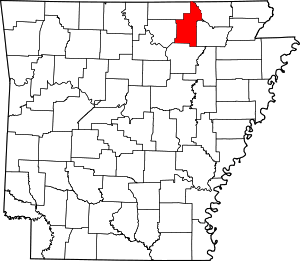 Location within the U.S. state of Arkansas | |
 Arkansas's location within the U.S. | |
| Coordinates: 36°09′21″N 91°30′18″W | |
| Country | |
| State | |
| Founded | July 18, 1868 |
| Named for | Ephraim Sharp |
| Seat | Ash Flat |
| Largest city | Cherokee Village |
| Area | |
| • Total | 606 sq mi (1,570 km2) |
| • Land | 604 sq mi (1,560 km2) |
| • Water | 2.0 sq mi (5 km2) 0.3%% |
| Population (2010) | |
| • Total | 17,264 |
| • Estimate (2019) | 17,442 |
| • Density | 28/sq mi (11/km2) |
| Time zone | UTC−6 (Central) |
| • Summer (DST) | UTC−5 (CDT) |
| Congressional district | 1st |
| Website | sharpcounty |
Sharp County was featured on the PBS program Independent Lens for its 1906 "banishment" of all of its Black residents. A local newspaper at the time was quoted as saying that "The community is better off without them."[3]
Geography
According to the U.S. Census Bureau, the county has a total area of 606 square miles (1,570 km2), of which 604 square miles (1,560 km2) is land and 2.0 square miles (5.2 km2) (0.3%) is water.[4]
Major highways


Adjacent counties
- Oregon County, Missouri (north)
- Randolph County (northeast)
- Lawrence County (southeast)
- Independence County (south)
- Izard County (southwest)
- Fulton County (northwest)
Demographics
| Historical population | |||
|---|---|---|---|
| Census | Pop. | %± | |
| 1870 | 5,400 | — | |
| 1880 | 9,047 | 67.5% | |
| 1890 | 10,418 | 15.2% | |
| 1900 | 12,199 | 17.1% | |
| 1910 | 11,688 | −4.2% | |
| 1920 | 11,132 | −4.8% | |
| 1930 | 10,715 | −3.7% | |
| 1940 | 11,497 | 7.3% | |
| 1950 | 8,999 | −21.7% | |
| 1960 | 6,319 | −29.8% | |
| 1970 | 8,233 | 30.3% | |
| 1980 | 14,607 | 77.4% | |
| 1990 | 14,109 | −3.4% | |
| 2000 | 17,119 | 21.3% | |
| 2010 | 17,264 | 0.8% | |
| Est. 2019 | 17,442 | [5] | 1.0% |
| U.S. Decennial Census[6] 1790–1960[7] 1900–1990[8] 1990–2000[9] 2010–2016[1] | |||
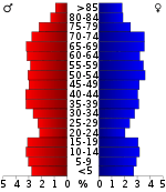
As of the 2000 census,[11] there were 17,119 people, 7,211 households, and 5,141 families residing in the county. The population density was 28 people per square mile (11/km²). There were 9,342 housing units at an average density of 16 per square mile (6/km²). The racial makeup of the county was 97.14% White, 0.49% Black or African American, 0.68% Native American, 0.12% Asian, 0.02% Pacific Islander, 0.16% from other races, and 1.39% from two or more races. 0.98% of the population were Hispanic or Latino of any race.
There were 7,211 households out of which 25.80% had children under the age of 18 living with them, 59.90% were married couples living together, 8.10% had a female householder with no husband present, and 28.70% were non-families. 25.60% of all households were made up of individuals and 14.40% had someone living alone who was 65 years of age or older. The average household size was 2.34 and the average family size was 2.79.
In the county, the population was spread out with 21.90% under the age of 18, 6.30% from 18 to 24, 22.80% from 25 to 44, 25.50% from 45 to 64, and 23.60% who were 65 years of age or older. The median age was 44 years. For every 100 females there were 92.40 males. For every 100 females age 18 and over, there were 90.20 males.
The median income for a household in the county was $25,152, and the median income for a family was $29,691. Males had a median income of $23,329 versus $16,884 for females. The per capita income for the county was $14,143. About 13.20% of families and 18.20% of the population were below the poverty line, including 25.40% of those under age 18 and 13.20% of those age 65 or over.
Government
Over The past few election cycles Sharp County has trended heavily towards the GOP. The last democrat (as of 2016) to carry this county was Bill Clinton in 1996.
| Year | GOP | Dem | Others |
|---|---|---|---|
| 2016 | 74.59% 5,407 | 20.31% 1,472 | 5.10% 370 |
| 2012 | 67.57% 4,921 | 28.72% 2,092 | 3.71% 270 |
| 2008 | 62.53% 4,535 | 33.59% 2,436 | 3.87% 281 |
| 2004 | 54.85% 4,097 | 43.71% 3,265 | 1.45% 108 |
| 2000 | 51.89% 3,698 | 45.41% 3,236 | 2.69% 192 |
| 1996 | 37.80% 2,635 | 51.26% 3,573 | 10.94% 762 |
| 1992 | 34.55% 2,486 | 52.27% 3,761 | 13.19% 949 |
| 1988 | 54.79% 3,623 | 44.69% 2,955 | 0.51% 34 |
| 1984 | 63.38% 4,392 | 35.96% 2,492 | 0.66% 46 |
| 1980 | 53.30% 3,420 | 43.24% 2,774 | 3.46% 222 |
| 1976 | 37.85% 2,151 | 62.15% 3,532 | |
| 1972 | 69.71% 2,677 | 30.05% 1,154 | 0.23% 9 |
| 1968 | 32.83% 1,136 | 29.62% 1,025 | 37.54% 1,299 |
| 1964 | 39.88% 1,215 | 59.40% 1,810 | 0.72% 22 |
| 1960 | 51.01% 911 | 45.18% 807 | 3.81% 68 |
| 1956 | 40.31% 645 | 57.94% 927 | 1.75% 28 |
| 1952 | 38.60% 655 | 61.23% 1,039 | 0.18% 3 |
| 1948 | 20.30% 295 | 74.19% 1,078 | 5.51% 80 |
| 1944 | 35.08% 664 | 64.29% 1,217 | 0.63% 12 |
| 1940 | 28.17% 433 | 71.50% 1,099 | 0.33% 5 |
| 1936 | 23.40% 289 | 75.63% 934 | 0.97% 12 |
| 1932 | 9.57% 142 | 89.89% 1,334 | 0.54% 8 |
| 1928 | 38.24% 501 | 61.68% 808 | 0.08% 1 |
| 1924 | 21.11% 210 | 73.27% 729 | 5.63% 56 |
| 1920 | 26.42% 400 | 65.72% 995 | 7.86% 119 |
| 1916 | 20.52% 251 | 79.48% 972 | 0.00% 0 |
| 1912 | 10.75% 114 | 64.25% 681 | 25.00% 265 |
| 1908 | 23.05% 317 | 70.55% 970 | 6.40% 88 |
| 1904 | 28.29% 288 | 65.91% 671 | 5.80% 59 |
| 1900 | 26.84% 394 | 72.14% 1,059 | 1.02% 15 |
| 1896 | 14.23% 230 | 85.58% 1,383 | 0.19% 3 |
Communities
Cities
- Ash Flat (county seat)
- Cave City
- Cherokee Village
- Hardy
- Highland
- Horseshoe Bend
Towns
Unincorporated communities
Townships
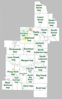
Townships in Arkansas are the divisions of a county. Each township includes unincorporated areas; some may have incorporated cities or towns within part of their boundaries. Arkansas townships have limited purposes in modern times. However, the United States Census does list Arkansas population based on townships (sometimes referred to as "county subdivisions" or "minor civil divisions"). Townships are also of value for historical purposes in terms of genealogical research. Each town or city is within one or more townships in an Arkansas county based on census maps and publications. The townships of Sharp County are listed below; listed in parentheses are the cities, towns, and/or census-designated places that are fully or partially inside the township. [13][14]
- Big Creek
- Cave (Cave City)
- Cherokee (most of Cherokee Village, small part of Highland)
- Davidson
- East Sullivan
- Hardy (most of Hardy)
- Highland (most of Highland)
- Jackson (Williford)
- Lave Creek
- Lower North
- Morgan
- North Big Rock
- North Lebanon
- Ozark
- Piney Fork (Evening Shade)
- Richwoods (part of Ash Flat, small part of Horseshoe Bend)
- Scott
- South Big Rock
- South Union
- Strawberry
- Upper North
- Washington
- West Sullivan (most of Sideny)
See also
- List of lakes in Sharp County, Arkansas
- National Register of Historic Places listings in Sharp County, Arkansas
References
- "State & County QuickFacts". United States Census Bureau. Retrieved May 19, 2014.
- "Find a County". National Association of Counties. Retrieved 2011-06-07.
- https://www.pbs.org/independentlens/banished/map.html
- "2010 Census Gazetteer Files". United States Census Bureau. August 22, 2012. Retrieved August 27, 2015.
- "Population and Housing Unit Estimates". Retrieved September 28, 2019.
- "U.S. Decennial Census". United States Census Bureau. Retrieved August 27, 2015.
- "Historical Census Browser". University of Virginia Library. Retrieved August 27, 2015.
- Forstall, Richard L., ed. (March 27, 1995). "Population of Counties by Decennial Census: 1900 to 1990". United States Census Bureau. Retrieved August 27, 2015.
- "Census 2000 PHC-T-4. Ranking Tables for Counties: 1990 and 2000" (PDF). United States Census Bureau. April 2, 2001. Retrieved August 27, 2015.
- Based on 2000 census data
- "U.S. Census website". United States Census Bureau. Retrieved 2011-05-14.
- "Dave Leip's Atlas of U.S. Presidential Elections". Retrieved November 18, 2016.
- 2011 Boundary and Annexation Survey (BAS): Sharp County, AR (PDF) (Map). U. S. Census Bureau. Archived from the original (PDF) on 2012-10-19. Retrieved 2011-08-04.
- "Arkansas: 2010 Census Block Maps - County Subdivision". United States Census Bureau. Retrieved May 29, 2014.
External links
- Sharp County, Arkansas entry on the Encyclopedia of Arkansas History & Culture
- Sharp County official website
- Ozark Acres Weather
Places adjacent to Sharp County, Arkansas | ||||||||||
|---|---|---|---|---|---|---|---|---|---|---|
| ||||||||||
Municipalities and communities of Sharp County, Arkansas, United States | ||
|---|---|---|
| Cities | Map of Arkansas highlighting Sharp County | |
| Towns | ||
| Unincorporated communities |
| |
| Footnotes | ‡This populated place also has portions in an adjacent county or counties | |

| Authority control |
|
|---|