Lee County, Arkansas
Lee County is a county located in the U.S. state of Arkansas. With its eastern border formed by the Mississippi River, it is considered to be part of the Arkansas Delta. As of the 2010 census, the population was 10,424.[1] The county seat is Marianna.[2]
Lee County | |
|---|---|
| County of Lee | |
 Main façade of the Lee County Courthouse, 2014 | |
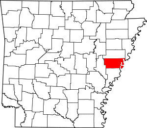 Location within the U.S. state of Arkansas | |
 Arkansas's location within the U.S. | |
| Coordinates: 34°46′32″N 90°46′29″W | |
| Country | |
| State | |
| Founded | April 17, 1873 |
| Named for | General Robert E. Lee |
| Seat | Marianna |
| Area | |
| • Total | 620 sq mi (1,600 km2) |
| • Land | 603 sq mi (1,560 km2) |
| • Water | 17 sq mi (40 km2) 2.7%% |
| Population (2010) | |
| • Total | 10,424 |
| • Estimate (2019) | 8,857 |
| • Density | 17/sq mi (6.5/km2) |
| Time zone | UTC−6 (Central) |
| • Summer (DST) | UTC−5 (CDT) |
| Congressional district | 1st |
| Website | leecounty |
The county was established on April 17, 1873, during the Reconstruction era. It was named for General Robert E. Lee, who served as General in Chief of the Armies of the Confederate States in 1865.[3][4] The area of the Delta was developed largely for cotton as a commodity crop before the Civil War, based on the labor of enslaved African Americans. It continued as an important crop into the 20th century, when it was worked by African-American sharecroppers and tenant farmers.
History
In the post-Reconstruction era, whites struggled to re-establish white supremacy, by violence and intimidation of black Republican voters in this area and throughout the South. At the turn of the century, the state legislature passed measures that effectively disenfranchised most blacks for decades. The Equal Justice Initiative reported in 2015 that the county had 15 lynchings of African Americans from 1877 to 1950,[5] most in the decades near the turn of the 20th century. This was the third-highest of any county in the state.[5] To escape the violence, thousands of African Americans left the state in the Great Migration to northern and western cities, especially after 1940.
Mechanization of farming and industrial-scale agriculture have decreased the need for workers. The rural county has continued to lose population because of the lack of work opportunities. There has been a decrease in population every decade since 1940.
Geography
According to the U.S. Census Bureau, the county has a total area of 620 square miles (1,600 km2), of which 603 square miles (1,560 km2) is land and 17 square miles (44 km2) (2.7%) is water.[6]
Major highways


- AR HWY 261
Adjacent counties
- St. Francis County (north)
- Crittenden County (northeast)
- Tunica County, Mississippi (east)
- Phillips County (south)
- Monroe County (west)
National protected area
- St. Francis National Forest (part)
Demographics
| Historical population | |||
|---|---|---|---|
| Census | Pop. | %± | |
| 1880 | 13,288 | — | |
| 1890 | 18,886 | 42.1% | |
| 1900 | 19,409 | 2.8% | |
| 1910 | 24,252 | 25.0% | |
| 1920 | 28,852 | 19.0% | |
| 1930 | 26,637 | −7.7% | |
| 1940 | 26,810 | 0.6% | |
| 1950 | 24,322 | −9.3% | |
| 1960 | 21,001 | −13.7% | |
| 1970 | 18,884 | −10.1% | |
| 1980 | 15,539 | −17.7% | |
| 1990 | 13,053 | −16.0% | |
| 2000 | 12,580 | −3.6% | |
| 2010 | 10,424 | −17.1% | |
| Est. 2019 | 8,857 | [7] | −15.0% |
| U.S. Decennial Census[8] 1790–1960[9] 1900–1990[10] 1990–2000[11] 2010–2016[1] | |||
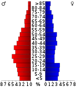
As of the 2010 United States Census, there were 10,424 people living in the county. 55.3% were Black or African American, 42.0% White, 0.5% Native American, 1.6% were Hispanic or Latino (of any race), 0.4% Asian, 0.7% of some other race and 1.2% of two or more races.
As of the 2000 United States Census,[13] there were 12,580 people, 4,182 households, and 2,960 families living in the county. The population density was 21 people per square mile (8/km2). There were 4,768 housing units at an average density of 8 per square mile (3/km2). The racial makeup of the county was 57.24% Black or African American, 41.41% White, 2.19% Hispanic or Latino of any race, 0.27% Asian, 0.16% Native American, 0.52% from other races, and 0.40% from two or more races.
There were 4,182 households, out of which 31.20% had children under the age of 18 living with them, 43.20% were married couples living together, 23.10% had a female householder with no husband present, and 29.20% were non-families. 27.20% of all households were made up of individuals, and 13.80% had someone living alone who was 65 years of age or older. The average household size was 2.59 and the average family size was 3.14.
In the county, the population was spread out, with 26.00% under the age of 18, 10.20% from 18 to 24, 28.70% from 25 to 44, 21.10% from 45 to 64, and 14.00% who were 65 years of age or older. The median age was 35 years. For every 100 females there were 111.40 males. For every 100 females age 18 and over, there were 118.40 males.
The median income for a household in the county was $20,510, and the median income for a family was $25,846. Males had a median income of $26,900 versus $19,505 for females. The per capita income for the county was $10,983. About 24.70% of families and 29.90% of the population were below the poverty line, including 38.80% of those under age 18 and 27.60% of those age 65 or over.
Government and infrastructure
The East Arkansas Regional Unit of the Arkansas Department of Correction is in Lee County.[14]
The Lee County Courthouse in located in the town of Marianna,[15] which is the county seat.[3]
Since World War II, Lee County has voted for the Democratic presidential candidate in all but two elections: 1948, when it voted for third-party Strom Thurmond rather than for Harry Truman, and in 1972, when formerly Democratic voters crossed party lines and voted for Republican Richard Nixon. The latter was the last year that white conservatives dominated county politics. Following passage and enforcement of the Voting Rights Act of 1965, newly registered African Americans began to support Democratic Party candidates. They have largely maintained this affiliation. Most whites have shifted into the Republican Party since the 1970s.
| Year | GOP | Dem | Others |
|---|---|---|---|
| 2016 | 40.61% 1,229 | 57.34% 1,735 | 2.05% 62 |
| 2012 | 37.38% 1,280 | 61.54% 2,107 | 1.08% 37 |
| 2008 | 38.64% 1,454 | 60.14% 2,263 | 1.22% 46 |
| 2004 | 36.57% 1,492 | 62.45% 2,548 | 0.98% 40 |
| 2000 | 32.78% 1,351 | 66.17% 2,727 | 1.05% 43 |
| 1996 | 22.25% 1,013 | 71.75% 3,267 | 5.99% 273 |
| 1992 | 25.52% 1,293 | 67.82% 3,436 | 6.65% 337 |
| 1988 | 38.72% 1,863 | 59.81% 2,878 | 1.48% 71 |
| 1984 | 44.54% 2,101 | 53.87% 2,541 | 1.59% 75 |
| 1980 | 35.09% 1,711 | 63.64% 3,103 | 1.27% 62 |
| 1976 | 31.24% 1,574 | 68.74% 3,463 | 0.02% 1 |
| 1972 | 64.59% 3,540 | 34.79% 1,907 | 0.62% 34 |
| 1968 | 17.10% 834 | 43.79% 2,135 | 39.11% 1,907 |
| 1964 | 41.59% 1,668 | 58.21% 2,335 | 0.20% 8 |
| 1960 | 38.28% 1,034 | 52.17% 1,409 | 9.55% 258 |
| 1956 | 34.61% 974 | 61.09% 1,719 | 4.30% 121 |
| 1952 | 35.27% 1,054 | 64.36% 1,923 | 0.37% 11 |
| 1948 | 6.37% 95 | 35.41% 528 | 58.21% 868 |
| 1944 | 19.70% 275 | 80.09% 1,118 | 0.21% 3 |
| 1940 | 8.99% 109 | 90.76% 1,100 | 0.25% 3 |
| 1936 | 4.98% 66 | 94.87% 1,257 | 0.15% 2 |
| 1932 | 2.32% 39 | 97.44% 1,635 | 0.24% 4 |
| 1928 | 12.47% 149 | 87.53% 1,046 | 0.00% 0 |
| 1924 | 35.00% 596 | 64.77% 1,103 | 0.23% 4 |
| 1920 | 23.60% 354 | 73.87% 1,108 | 2.53% 38 |
| 1916 | 29.39% 353 | 70.61% 848 | 0.00% 0 |
| 1912 | 36.10% 665 | 52.55% 968 | 11.34% 209 |
| 1908 | 22.56% 354 | 75.33% 1,182 | 2.10% 33 |
| 1904 | 48.26% 1,569 | 51.74% 1,682 | 0.00% 0 |
| 1900 | 31.26% 1,296 | 68.74% 2,850 | 0.00% 0 |
| 1896 | 9.68% 213 | 88.41% 1,946 | 1.91% 42 |
Communities
Unincorporated communities
Townships
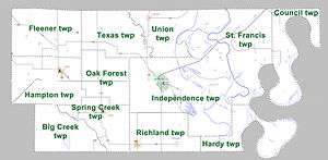
Townships in Arkansas are the divisions of a county. Each township includes unincorporated areas; some may have incorporated cities or towns within part of their boundaries. Arkansas townships have limited purposes in modern times. However, the United States Census does list Arkansas population based on townships (sometimes referred to as "county subdivisions" or "minor civil divisions"). Townships are also of value for historical purposes in terms of genealogical research. Each town or city is within one or more townships in an Arkansas county based on census maps and publications. The townships of Lee County are listed below; listed in parentheses are the cities, towns, and/or census-designated places that are fully or partially inside the township. [17][18]
See also
- Jones Bar-B-Q Diner, Arkansas' only James Beard Award-winning restaurant
- List of counties in Arkansas
- List of lakes in Lee County, Arkansas
- List of memorials to Robert E. Lee
- National Register of Historic Places listings in Lee County, Arkansas
References
- "State & County QuickFacts". United States Census Bureau. Archived from the original on June 7, 2011. Retrieved May 23, 2014.
- "Find a County". National Association of Counties. Retrieved 2011-06-07.
- "Lee County". Local.Arkansas.gov: County and Municipal Information & Services. Retrieved 29 November 2012.
- Gannett, Henry (1905). The Origin of Certain Place Names in the United States (Report). U.S. Geological survey. Bulletin no. 258 (2nd ed.). Washington: Government Printing Office. p. 184. LCCN 05000751. OCLC 1156805 – via United States Geological Survey.
- Lynching in America/ Supplement: Lynchings by County: Arkansas - Lee County, 3rd Edition, 2015, p. 2
- "2010 Census Gazetteer Files". United States Census Bureau. August 22, 2012. Retrieved August 27, 2015.
- "Population and Housing Unit Estimates". Retrieved September 28, 2019.
- "U.S. Decennial Census". United States Census Bureau. Retrieved August 27, 2015.
- "Historical Census Browser". University of Virginia Library. Retrieved August 27, 2015.
- Forstall, Richard L., ed. (March 27, 1995). "Population of Counties by Decennial Census: 1900 to 1990". United States Census Bureau. Retrieved August 27, 2015.
- "Census 2000 PHC-T-4. Ranking Tables for Counties: 1990 and 2000" (PDF). United States Census Bureau. April 2, 2001. Retrieved August 27, 2015.
- Based on 2000 census data
- "U.S. Census website". United States Census Bureau. Retrieved 2011-05-14.
- "Facilities: East Arkansas Regional Unit". Arkansas Department of Correction. Archived from the original on June 28, 2011. Retrieved March 8, 2011.
- "Lee County Arkansas Courthouse". County Criminal Records. Retrieved 29 November 2012.
- "Dave Leip's Atlas of U.S. Presidential Elections". Retrieved November 18, 2016.
- 2011 Boundary and Annexation Survey (BAS): Lee County, AR (PDF) (Map). U. S. Census Bureau. Archived from the original (PDF) on 2012-10-19. Retrieved 2011-08-09.
- "Arkansas: 2010 Census Block Maps - County Subdivision". United States Census Bureau. Archived from the original on May 28, 2014. Retrieved May 29, 2014.
External links
| Wikimedia Commons has media related to Lee County, Arkansas. |
Places adjacent to Lee County, Arkansas | ||||||||||
|---|---|---|---|---|---|---|---|---|---|---|
| ||||||||||
Municipalities and communities of Lee County, Arkansas, United States | ||
|---|---|---|
| City | Map of Arkansas highlighting Lee County | |
| Towns | ||
| Unincorporated communities | ||
| Footnotes | ‡This populated place also has portions in an adjacent county or counties | |

| Authority control |
|
|---|