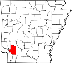
Hempstead County, Arkansas
Hempstead County is a county located in the U.S. state of Arkansas. As of the 2010 census, the population was 22,609.[1] The county seat is Hope.[2] Hempstead County is Arkansas's fourth county, formed on December 15, 1818, alongside Clark and Pulaski counties. The county is named for Edward Hempstead, a delegate to the U.S. Congress from the Missouri Territory, which included present-day Arkansas at the time.[3] It is an alcohol prohibition or dry county.
Hempstead County | |
|---|---|
County | |
| County of Hempstead | |
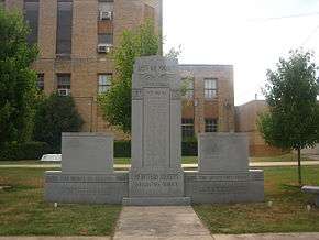
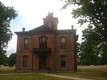
.jpg) .jpg) .jpg) 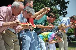 Clockwise from top: Hempstead County Courthouse in Hope, Bill Clinton Birthplace, Politicians at the Hope Watermelon Festival, the former Hempstead County Courthouse) | |
 Location within the U.S. state of Arkansas | |
 Arkansas's location within the U.S. | |
| Coordinates: 33°44′37″N 93°39′49″W | |
| Country | |
| State | |
| Founded | December 15, 1818 |
| Named for | Edward Hempstead |
| Seat | Hope |
| Largest city | Hope |
| Area | |
| • Total | 741 sq mi (1,920 km2) |
| • Land | 728 sq mi (1,890 km2) |
| • Water | 14 sq mi (40 km2) 1.8%% |
| Population (2010) | |
| • Total | 22,609 |
| • Estimate (2019) | 21,532 |
| • Density | 31/sq mi (12/km2) |
| Time zone | UTC−6 (Central) |
| • Summer (DST) | UTC−5 (CDT) |
| Congressional district | 4th |
| Website | www |
Historic Washington State Park is located in Hempstead County some nine miles northwest of Hope in the historic village of Washington, Arkansas. The state park opened in 1973 as "Old Washington Historic State Park", but the "Old" was dropped from the name in 2006. The park offers walking tours of the historic village, which contains more than a dozen historic structures from the 19th and early 20th centuries.
Geography
According to the U.S. Census Bureau, the county has a total area of 741 square miles (1,920 km2), of which 728 square miles (1,890 km2) is land and 14 square miles (36 km2) (1.8%) is water.[4] Hempstead County is alternately considered as part of the greater regions of South Arkansas or Southwest Arkansas.
Major highways
.svg.png)


Adjacent counties
- Pike County (north)
- Nevada County (east)
- Lafayette County (south)
- Miller County (southwest)
- Little River County (west)
- Howard County (northwest)
Demographics
| Historical population | |||
|---|---|---|---|
| Census | Pop. | %± | |
| 1830 | 2,512 | — | |
| 1840 | 4,921 | 95.9% | |
| 1850 | 7,672 | 55.9% | |
| 1860 | 13,989 | 82.3% | |
| 1870 | 13,768 | −1.6% | |
| 1880 | 19,015 | 38.1% | |
| 1890 | 22,796 | 19.9% | |
| 1900 | 24,101 | 5.7% | |
| 1910 | 28,285 | 17.4% | |
| 1920 | 31,602 | 11.7% | |
| 1930 | 30,847 | −2.4% | |
| 1940 | 32,770 | 6.2% | |
| 1950 | 25,080 | −23.5% | |
| 1960 | 19,661 | −21.6% | |
| 1970 | 19,308 | −1.8% | |
| 1980 | 23,635 | 22.4% | |
| 1990 | 21,621 | −8.5% | |
| 2000 | 23,587 | 9.1% | |
| 2010 | 22,609 | −4.1% | |
| Est. 2019 | 21,532 | [5] | −4.8% |
| U.S. Decennial Census[6] 1790–1960[7] 1900–1990[8] 1990–2000[9] 2010–2016[1] | |||
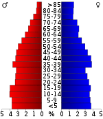
As of the 2000 census,[11] there were 23,587 people, 8,959 households, and 6,378 families residing in the county. The population density was 32 people per square mile (12/km2). There were 10,178 housing units at an average density of 14 per square mile (5/km2). The racial makeup of the county was 63.28% White, 30.36% Black or African American, 0.42% Native American, 0.17% Asian, 0.02% Pacific Islander, 4.17% from other races, and 1.59% from two or more races. 8.25% of the population were Hispanic or Latino of any race.
There were 8,959 households, out of which 33.40% had children under the age of 18 living with them, 51.40% were married couples living together, 15.30% had a female householder with no husband present, and 28.80% were non-families. 25.50% of all households were made up of individuals, and 11.70% had someone living alone who was 65 years of age or older. The average household size was 2.60 and the average family size was 3.09.
In the county, the population was spread out, with 27.30% under the age of 18, 9.60% from 18 to 24, 27.20% from 25 to 44, 21.70% from 45 to 64, and 14.10% who were 65 years of age or older. The median age was 35 years. For every 100 females, there were 93.70 males. For every 100 females age 18 and over, there were 89.70 males.
The median income for a household in the county was $28,622, and the median income for a family was $34,082. Males had a median income of $25,830 versus $17,383 for females. The per capita income for the county was $14,103. About 16.00% of families and 20.30% of the population were below the poverty line, including 29.20% of those under age 18 and 16.70% of those age 65 or over.
Government
Although historically Democratic, Hempstead County has trended Republican in the last two decades. John Kerry was the last Democrat to carry the county.
| Year | GOP | DEM | Others |
|---|---|---|---|
| 2016 | 62.43% 4,401 | 33.72% 2,377 | 3.84% 271 |
| 2012 | 61.90% 4,284 | 35.66% 2,468 | 2.44% 169 |
| 2008 | 58.14% 4,273 | 39.04% 2,869 | 2.82% 207 |
| 2004 | 48.04% 3,580 | 51.22% 3,817 | 0.74% 55 |
| 2000 | 44.68% 3,257 | 54.01% 3,937 | 1.31% 95 |
| 1996 | 26.76% 2,021 | 65.99% 4,983 | 7.24% 547 |
| 1992 | 26.75% 2,387 | 61.38% 5,476 | 11.86% 1,059 |
| 1988 | 50.49% 3,938 | 49.25% 3,841 | 0.26% 20 |
| 1984 | 59.31% 4,904 | 40.24% 3,327 | 0.45% 37 |
| 1980 | 44.65% 3,852 | 54.14% 4,671 | 1.21% 105 |
| 1976 | 34.63% 2,859 | 65.37% 5,397 | |
| 1972 | 70.80% 4,963 | 29.20% 2,047 | 0.00% 0 |
| 1968 | 24.62% 1,783 | 32.07% 2,322 | 43.31% 3,136 |
| 1964 | 42.32% 2,493 | 56.95% 3,355 | 0.73% 43 |
| 1960 | 40.93% 1,948 | 54.55% 2,596 | 4.52% 215 |
| 1956 | 44.57% 2,227 | 53.91% 2,694 | 1.52% 76 |
| 1952 | 43.28% 2,115 | 56.70% 2,771 | 0.02% 1 |
| 1948 | 12.58% 386 | 54.84% 1,683 | 32.59% 1,000 |
| 1944 | 22.37% 624 | 77.34% 2,157 | 0.29% 8 |
| 1940 | 12.85% 415 | 87.15% 2,814 | 0.00% 0 |
| 1936 | 7.24% 190 | 92.68% 2,431 | 0.08% 2 |
| 1932 | 10.03% 317 | 89.90% 2,840 | 0.06% 2 |
| 1928 | 30.25% 886 | 69.58% 2,038 | 0.17% 5 |
| 1924 | 30.37% 715 | 61.98% 1,459 | 7.65% 180 |
| 1920 | 43.65% 1,754 | 55.72% 2,239 | 0.62% 25 |
| 1916 | 37.05% 1,238 | 62.95% 2,103 | 0.00% 0 |
| 1912 | 31.63% 836 | 47.18% 1,247 | 21.19% 560 |
| 1908 | 41.68% 1,346 | 55.09% 1,779 | 3.22% 104 |
| 1904 | 49.41% 1,477 | 47.17% 1,410 | 3.41% 102 |
| 1900 | 49.11% 1,330 | 49.93% 1,352 | 0.96% 26 |
| 1896 | 39.26% 1,203 | 59.79% 1,832 | 0.95% 29 |
Communities
Cities
- Blevins
- Hope (county seat)
- Washington
Townships
Townships in Arkansas are the divisions of a county. Each township includes unincorporated areas; some may have incorporated cities or towns within part of their boundaries. Arkansas townships have limited purposes in modern times. However, the United States Census does list Arkansas population based on townships (sometimes referred to as "county subdivisions" or "minor civil divisions"). Townships are also of value for historical purposes in terms of genealogical research. Each town or city is within one or more townships in an Arkansas county based on census maps and publications. The townships of Hempstead County are listed below; listed in parentheses are the cities, towns, and/or census-designated places that are fully or partially inside the township. [13][14]
See also
- List of lakes in Hempstead County, Arkansas
- National Register of Historic Places listings in Hempstead County, Arkansas
References
- "State & County QuickFacts". United States Census Bureau. Archived from the original on June 7, 2011. Retrieved May 21, 2014.
- "Find a County". National Association of Counties. Archived from the original on 2011-05-31. Retrieved 2011-06-07.
- Gannett, Henry (1905). The Origin of Certain Place Names in the United States. Govt. Print. Off. pp. 154.
- "2010 Census Gazetteer Files". United States Census Bureau. August 22, 2012. Retrieved August 26, 2015.
- "Population and Housing Unit Estimates". Retrieved September 28, 2019.
- "U.S. Decennial Census". United States Census Bureau. Retrieved August 26, 2015.
- "Historical Census Browser". University of Virginia Library. Retrieved August 26, 2015.
- Forstall, Richard L., ed. (March 27, 1995). "Population of Counties by Decennial Census: 1900 to 1990". United States Census Bureau. Retrieved August 26, 2015.
- "Census 2000 PHC-T-4. Ranking Tables for Counties: 1990 and 2000" (PDF). United States Census Bureau. April 2, 2001. Retrieved August 26, 2015.
- Based on 2000 census data
- "U.S. Census website". United States Census Bureau. Retrieved 2011-05-14.
- "Dave Leip's Atlas of U.S. Presidential Elections". Retrieved November 18, 2016.
- 2011 Boundary and Annexation Survey (BAS): Hempstead County, AR (PDF) (Map). U. S. Census Bureau. Archived from the original (PDF) on 2012-10-19. Retrieved 2011-08-24.
- "Arkansas: 2010 Census Block Maps - County Subdivision". United States Census Bureau. Retrieved May 28, 2014.
External links
Places adjacent to Hempstead County, Arkansas | ||||||||||
|---|---|---|---|---|---|---|---|---|---|---|
| ||||||||||
Municipalities and communities of Hempstead County, Arkansas, United States | ||
|---|---|---|
| Cities | Map of Arkansas highlighting Hempstead County | |
| Towns | ||
| Unincorporated communities | ||
| Footnotes | ‡This populated place also has portions in an adjacent county or counties | |

| Authority control |
|
|---|