White County, Arkansas
White County is a county located in the U.S. state of Arkansas. As of the 2010 census, the population was 77,076.[1] The county seat is Searcy.[2] White County is Arkansas's 31st county, formed on October 23, 1835, from portions of Independence, Jackson, and Pulaski counties and named for Hugh Lawson White, a Whig candidate for President of the United States. It is an alcohol prohibition or dry county, though a few private establishments (such as the Searcy Country Club, and Veterans of Foreign Wars posts in Searcy and Beebe) can serve alcohol.
White County | |
|---|---|
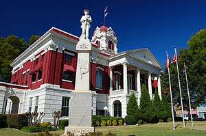 White County Courthouse and Confederate monument in Searcy | |
 Flag  Seal | |
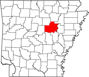 Location within the U.S. state of Arkansas | |
 Arkansas's location within the U.S. | |
| Coordinates: 35°15′21″N 91°44′05″W | |
| Country | |
| State | |
| Founded | October 23, 1835 |
| Named for | Hugh Lawson White |
| Seat | Searcy |
| Largest city | Searcy |
| Area | |
| • Total | 1,042 sq mi (2,700 km2) |
| • Land | 1,035 sq mi (2,680 km2) |
| • Water | 7.1 sq mi (18 km2) 0.7%% |
| Population (2010) | |
| • Total | 77,076 |
| • Estimate (2019) | 78,753 |
| • Density | 74/sq mi (29/km2) |
| Time zone | UTC−6 (Central) |
| • Summer (DST) | UTC−5 (CDT) |
| Congressional district | 2nd |
| Website | www |
White County comprises the Searcy, AR Micropolitan Statistical Area, which is also included in the Little Rock-North Little Rock, AR Combined Statistical Area.
The 45th and current White County Judge is Michael Lincoln of Searcy, who assumed office in January 2007.
History
On May 17, 1862, White County was the site of the Little Red Skirmish between Union Major General Samuel J Curtis and a force of about 100 loosely-organized rebels, followed by the Action at Whitney Lane in June.[3] also known as The Skirmish at Searcy Landing.[4]
In 1958, Odell Pollard, a retired attorney from Searcy, exposed corrupt election practices at Bald Knob, a small city in White County. Election workers cast "absentee ballots" for some 30 pipeline construction workers and their spouses. However, the workers were outside of Arkansas at the time of the election, which had a prohibition measure on the ballot. The voters never cast absentee votes, according to their affidavits presented by Pollard to the White County prosecutor. No action was taken until after the statute of limitations had expired, when the charges were moot. Pollard said the fraud case made him to switch his partisan affiliation from Democrat to Republican. From 1966 to 1970, Pollard was the state party chairman, and from 1973 to 1976, he was the Arkansas Republican National Committeeman.[5]
In 1988, White County elected virtually an entire slate of Republicans to county offices. Though such Republican sweeps had frequently occurred in northern and northwestern Arkansas, White County was the first in the Little Rock area to turn to Republican as the party steadily made inroads toward a two-party system.[6]
A portion of White County is represented in the Arkansas State Senate by the Republican Ronald R. Caldwell, a real estate businessman from Wynne in Cross County.
Geography
According to the U.S. Census Bureau, the county has a total area of 1,042 square miles (2,700 km2), of which 1,035 square miles (2,680 km2) is land and 7.1 square miles (18 km2) (0.7%) is water.[7] It is the second-largest county by area in Arkansas.
Major highways
.svg.png)


Adjacent counties
- Independence County (north)
- Jackson County (northeast)
- Woodruff County (east)
- Prairie County (southeast)
- Lonoke County (southwest)
- Faulkner County (west)
- Cleburne County (northwest)
National and state protected areas
- Bald Knob National Wildlife Refuge
- Henry Gray / Hurricane Lake Wildlife Management Area[8]
Demographics
| Historical population | |||
|---|---|---|---|
| Census | Pop. | %± | |
| 1840 | 929 | — | |
| 1850 | 2,619 | 181.9% | |
| 1860 | 8,316 | 217.5% | |
| 1870 | 10,347 | 24.4% | |
| 1880 | 17,794 | 72.0% | |
| 1890 | 22,946 | 29.0% | |
| 1900 | 24,864 | 8.4% | |
| 1910 | 28,574 | 14.9% | |
| 1920 | 34,603 | 21.1% | |
| 1930 | 38,269 | 10.6% | |
| 1940 | 37,176 | −2.9% | |
| 1950 | 38,040 | 2.3% | |
| 1960 | 32,745 | −13.9% | |
| 1970 | 39,253 | 19.9% | |
| 1980 | 50,835 | 29.5% | |
| 1990 | 54,676 | 7.6% | |
| 2000 | 67,165 | 22.8% | |
| 2010 | 77,076 | 14.8% | |
| Est. 2019 | 78,753 | [9] | 2.2% |
| U.S. Decennial Census[10] 1790–1960[11] 1900–1990[12] 1990–2000[13] 2010–2016[1] | |||
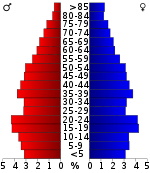
As of the 2000 United States Census,[15] there were 67,165 people, 25,148 households, and 18,408 families residing in the county. The population density was 65 people per square mile (25/km²). There were 27,613 housing units at an average density of 27 per square mile (10/km²). The racial makeup of the county was 93.52% White, 3.56% Black or African American, 0.43% Native American, 0.32% Asian, 0.03% Pacific Islander, 0.82% from other races, and 1.31% from two or more races. 1.88% of the population were Hispanic or Latino of any race.
There were 25,148 households out of which 33.00% had children under the age of 18 living with them, 59.90% were married couples living together, 9.50% had a female householder with no husband present, and 26.80% were non-families. 23.40% of all households were made up of individuals and 10.50% had someone living alone who was 65 years of age or older. The average household size was 2.53 and the average family size was 2.98.
In the county, the population was spread out with 24.40% under the age of 18, 12.80% from 18 to 24, 27.20% from 25 to 44, 21.90% from 45 to 64, and 13.80% who were 65 years of age or older. The median age was 35 years. For every 100 females, there were 95.20 males. For every 100 females age 18 and over, there were 92.90 males.
The median income for a household in the county was $32,203, and the median income for a family was $38,782. Males had a median income of $29,884 versus $20,323 for females. The per capita income for the county was $15,890. About 10.40% of families and 14.00% of the population were below the poverty line, including 18.10% of those under age 18 and 14.30% of those age 65 or over.
Government
Over The past few election cycles White County has trended heavily towards the GOP. The last democrat (as of 2016) to carry this county was Bill Clinton in 1996.
| Year | GOP | Dem | Others |
|---|---|---|---|
| 2016 | 75.28% 21,077 | 18.46% 5,170 | 6.26% 1,752 |
| 2012 | 75.47% 20,011 | 21.74% 5,765 | 2.78% 738 |
| 2008 | 72.22% 19,467 | 24.97% 6,732 | 2.80% 756 |
| 2004 | 64.34% 17,001 | 34.55% 9,129 | 1.12% 295 |
| 2000 | 59.46% 13,170 | 37.66% 8,342 | 2.88% 638 |
| 1996 | 41.25% 8,659 | 48.61% 10,204 | 10.14% 2,128 |
| 1992 | 39.60% 8,538 | 48.67% 10,494 | 11.74% 2,531 |
| 1988 | 60.84% 11,094 | 38.15% 6,957 | 1.00% 183 |
| 1984 | 64.66% 12,566 | 33.97% 6,603 | 1.37% 266 |
| 1980 | 46.66% 8,079 | 50.54% 8,750 | 2.79% 484 |
| 1976 | 29.42% 4,756 | 70.58% 11,412 | |
| 1972 | 67.24% 8,701 | 32.15% 4,161 | 0.61% 79 |
| 1968 | 32.02% 3,887 | 26.34% 3,198 | 41.63% 5,054 |
| 1964 | 42.99% 5,023 | 56.20% 6,566 | 0.81% 95 |
| 1960 | 40.52% 3,985 | 53.33% 5,244 | 6.15% 605 |
| 1956 | 43.58% 3,813 | 55.94% 4,895 | 0.48% 42 |
| 1952 | 40.79% 2,884 | 59.11% 4,179 | 0.10% 7 |
| 1948 | 18.01% 833 | 69.04% 3,193 | 12.95% 599 |
| 1944 | 34.71% 1,346 | 65.29% 2,532 | 0.00% 0 |
| 1940 | 20.64% 876 | 78.80% 3,345 | 0.57% 24 |
| 1936 | 17.57% 535 | 82.20% 2,503 | 0.23% 7 |
| 1932 | 11.61% 430 | 87.75% 3,251 | 0.65% 24 |
| 1928 | 45.73% 1,957 | 53.73% 2,299 | 0.54% 23 |
| 1924 | 27.69% 679 | 60.69% 1,488 | 11.62% 285 |
| 1920 | 37.82% 1,359 | 58.06% 2,086 | 4.12% 148 |
| 1916 | 19.25% 673 | 80.75% 2,823 | 0.00% 0 |
| 1912 | 15.10% 380 | 57.53% 1,448 | 27.37% 689 |
| 1908 | 29.20% 887 | 58.85% 1,788 | 11.95% 363 |
| 1904 | 31.40% 676 | 57.50% 1,238 | 11.10% 239 |
| 1900 | 30.26% 811 | 63.21% 1,694 | 6.53% 175 |
| 1896 | 16.16% 559 | 83.12% 2,876 | 0.72% 25 |
Economy
One of the state's largest banks, First Security Bank, was established in Searcy in 1932 as Security Bank. First Security now has over $4 billion in assets and 70 locations in Arkansas.
Regional ice cream producer and distributor Yarnell Ice Cream Co. has its headquarters in the Searcy's downtown area.
Latina Imports and Latina Nursery are also located in Searcy and is one of the largest female, Hispanic-owned companies in Arkansas.
The first Wal-Mart distribution center away from the corporate headquarters in Bentonville was established in Searcy.
Education
Public education
Public education is provided by several public school districts including:
|
|
Private education
|
|
Colleges and universities
- Arkansas State University-Beebe Public, established in 1927 as The Junior Agricultural School of Central Arkansas.
- Arkansas State University-Searcy A technical branch of Arkansas State University
- Harding University Private, Churches of Christ enrollment over 6000.
Communities
Unincorporated communities
- Albion — north-central White County, between Four Mile Hill or "Boothill" and Pangburn, and north of Letona, along Arkansas Highway 16 and surrounding county roads
- Antioch — western White County, north of Beebe, along Arkansas Highways 31 and 267 and surrounding county roads
- Andrews
- Bare Stone
- Barrentine Corner
- Bee Rock
- Belcher
- Center Hill — central White County, approximately 8 miles west of Searcy, situated along Arkansas Highway 36 and 305 and surrounding county roads
- Clay
- Conant
- Crosby
- Dewey
- Dogwood
- Doniphan
- El Paso — southwestern White County, situated along Arkansas Highway 5 and U.S. Highway 64 West
- Enright
- Essex
- Floyd — western White County, approximately 8 miles southeast of Romance, along Arkansas Highways 31 and 305 and surrounding county roads
- Four Mile Hill or "Boot Hill" — central White County, northwest of Searcy and southeast of Albion, along Arkansas Highway 16 and surrounding county roads
- Georgia Ridge – home community of Arkansas State Representative Charlotte Douglas of District 75 in Crawford County
- Gravel Hill — western White County, northwest of Floyd and south of Joy, situated between Arkansas Highways 31 and 36 along Gravel Hill Road and surrounding county roads
- Hammondsville – western White County, between Romance and El Paso, primarily situated along Hammons Chapel Road (connecting Highway 5 and El Paso Road)
- Happy
- Harmony — central White County, southwest of Center Hill, situated along Arkansas Highway 305 and surrounding county roads
- Hart
- Hickory Flat
- Holly Springs
- Joy — central White County, between Rose Bud and Center Hill, situated along Arkansas Highway 36 and surrounding county roads
- Keeler Corner
- Liberty Valley — eastern White County, between Bald Knob and the White River, along U.S. Highway 64 East and surrounding county roads
- Little Red
- Midway
- Mitchell Corner
- Morning Sun — annexed to Higginson in 2008
- Nimmo
- Opal — southwestern White County, between El Paso and Beebe, along U.S. Highway 64 West and Opal Road and surrounding county roads
- Pickens — north-central White County, between Sidon and Letona, along Arkansas Highway 310 (Pickens Chapel Road) and Pickens Road and surrounding county roads
- Plainview — northeastern White County, north of Judsonia, along Arkansas Highways 157 and 385 and surrounding county roads
- Pryor
- Providence — northeastern White County, north of Judsonia and northwest of Bald Knob, along Arkansas Highways 157 and 258 and surrounding county roads; site of White County Central Schools
- Rio Vista
- Romance — western White County, between Rose Bud and El Paso, along Arkansas Highways 5 and 31 and surrounding county roads
- Showalter's Corner
- Sidon — north-central White County, west of Pickens and north of Joy, along Arkansas Highway 310 and surrounding county roads
- Smyrna
- Steprock
- Sunnydale
- Twentythree
- Velvet Ridge — northeastern White County, north of Bald Knob, along U.S. Highway 167 and surrounding county roads
- Vinity Corner — south-central White County, south of Garner and southeast of McRae, along West Vinity Road, North Vinity Road, and other county roads southeast of Arkansas Highway 367
- Walker — southeastern White County, south of Higginson and west of Griffithville, along Arkansas Highway 11 (Walker Road) and surrounding county roads
- Worden
- Wright's Corner
Historic towns
- Beeler Ferry
- Bethel Grove
- Denmark
- Jasmine
- Mount Pisgah
- Old Stoney Point
- Roosevelt
- Russell
- Union Hill
Townships
Townships in Arkansas are the divisions of a county. Each township includes unincorporated areas; some may have incorporated cities or towns within part of their boundaries. Arkansas townships have limited purposes in modern times. However, the United States Census does list Arkansas population based on townships (sometimes referred to as "county subdivisions" or "minor civil divisions"). Townships are also of value for historical purposes in terms of genealogical research. Each town or city is within one or more townships in an Arkansas county based on census maps and publications. The townships of White County are listed below; listed in parentheses are the cities, towns, and/or census-designated places that are fully or partially inside the township. [17][18]
- Albion
- Antioch
- Bald Knob (Bald Knob)
- Big Creek (Pangburn)
- Cadron
- Cane
- Chrisp
- Clay
- Cleveland
- Coffey
- Coldwell
- Crosby
- Cypert
- Denmark
- Des Arc
- Dogwood (Griffithville)
- El Paso
- Francure (Georgetown)
- Garner (Garner)
- Gravel Hill
- Gray (most of Searcy, part of Kensett)
- Gum Springs (part of Searcy)
- Guthrie
- Harrison (most of Judsonia, part of Searcy)
- Hartsell Township
- Higginson Township (Higginson, part of Searcy)
- Jackson
- Jefferson
- Joy
- Kensett (most of Kensett, small part of Searcy)
- Kentucky (Rose Bud)
- Liberty (Bradford)
- McRae (McRae)
- Marion (Letona)
- Marshall
- Mount Pisgah
- Red River (West Point, part of Judsonia)
- Royal
- Russell (Russell)
- Union (Beebe)
- Velvet Ridge
- Walker
Source:[19]
See also
- Crow Lake (Arkansas)
- List of lakes in White County, Arkansas
- National Register of Historic Places listings in White County, Arkansas
References
- "State & County QuickFacts". United States Census Bureau. Retrieved May 19, 2014.
- "Find a County". National Association of Counties. Retrieved 2011-06-07.
- "Skirmish at Little Red River (May 17, 1862)". Encyclopedia of Arkansas. 2011-09-13. Retrieved 2018-11-30.
- "Action at Whitney's Lane". Encyclopedia of Arkansas. Retrieved 2018-11-30.
- Statement of Odell Pollard, Searcy attorney, December 30, 2009
- Osro Cobb, Osro Cobb of Arkansas: Memoirs of Historical Significance, Carol Griffee, ed. (Little Rock, Arkansas: Rose Publishing Company, 1989), p. 114
- "2010 Census Gazetteer Files". United States Census Bureau. August 22, 2012. Retrieved August 27, 2015.
- "Wildlife Management Areas". AGFC. Archived from the original on 2010-02-01. Retrieved 2013-07-10.
- "Population and Housing Unit Estimates". Retrieved September 28, 2019.
- "U.S. Decennial Census". United States Census Bureau. Retrieved August 27, 2015.
- "Historical Census Browser". University of Virginia Library. Retrieved August 27, 2015.
- Forstall, Richard L., ed. (March 27, 1995). "Population of Counties by Decennial Census: 1900 to 1990". United States Census Bureau. Retrieved August 27, 2015.
- "Census 2000 PHC-T-4. Ranking Tables for Counties: 1990 and 2000" (PDF). United States Census Bureau. April 2, 2001. Retrieved August 27, 2015.
- Based on 2000 census data
- "U.S. Census website". United States Census Bureau. Retrieved 2011-05-14.
- "Dave Leip's Atlas of U.S. Presidential Elections". Retrieved November 18, 2016.
- 2011 Boundary and Annexation Survey (BAS): White County, AR (PDF) (Map). U. S. Census Bureau. Archived from the original (PDF) on 2012-10-19. Retrieved 2011-08-24.
- "Arkansas: 2010 Census Block Maps – County Subdivision". United States Census Bureau. Retrieved May 29, 2014.
- "Summary Population and Housing Characteristics, CPH-1-5, Arkansas" (PDF). 2010 Census of Population and Housing. United States Census Bureau. September 2012. Retrieved May 31, 2014.
External links
- White County, Arkansas entry on the Encyclopedia of Arkansas History & Culture
- White County Historical Society
- White County official website
Places adjacent to White County, Arkansas | ||||||||||
|---|---|---|---|---|---|---|---|---|---|---|
| ||||||||||
Municipalities and communities of White County, Arkansas, United States | ||
|---|---|---|
| Cities | Map of Arkansas highlighting White County | |
| Towns | ||
| Unincorporated communities |
| |

| Authority control |
|
|---|