Logan County, Arkansas
Logan County (formerly Sarber County) is a county located in the U.S. state of Arkansas. As of the 2010 census, the population was 22,353.[1] Its two county seats are Booneville and Paris.[2]
Logan County | |
|---|---|
%2C_Paris%2C_AR_002.jpg) Logan County Courthouse, Paris | |
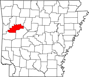 Location within the U.S. state of Arkansas | |
 Arkansas's location within the U.S. | |
| Coordinates: 35°13′29″N 93°44′26″W | |
| Country | |
| State | |
| Founded | March 22, 1871 |
| Named for | James Logan |
| Seat | Paris (northern district); Booneville (southern district) |
| Largest city | Booneville |
| Area | |
| • Total | 732 sq mi (1,900 km2) |
| • Land | 708 sq mi (1,830 km2) |
| • Water | 23 sq mi (60 km2) 3.2%% |
| Population (2010) | |
| • Total | 22,353 |
| • Estimate (2019) | 21,466 |
| • Density | 31/sq mi (12/km2) |
| Time zone | UTC−6 (Central) |
| • Summer (DST) | UTC−5 (CDT) |
| Congressional district | 4th |
History
The Arkansas General Assembly defined the state's 64th county on March 22, 1871, and named it Sarber County for John N. Sarber, the Republican state senator from Yell County, who had introduced the resolution. The senator was viewed as a carpetbagger, and after the Reconstruction-era state government was replaced, the county was renamed for James Logan, an early settler in the area, on December 14, 1875.[3]
Geography
According to the U.S. Census Bureau, the county has a total area of 732 square miles (1,900 km2), of which 708 square miles (1,830 km2) are land and 23 square miles (60 km2) (3.2%) are water.[4] The highest natural point in Arkansas, Magazine Mountain at 2,753 feet (839 m), is located in Logan County.
Major highways


Adjacent counties
- Johnson County (north)
- Pope County (northeast)
- Yell County (southeast)
- Scott County (south)
- Sebastian County (west)
- Franklin County (northwest)
Demographics
| Historical population | |||
|---|---|---|---|
| Census | Pop. | %± | |
| 1880 | 14,885 | — | |
| 1890 | 20,774 | 39.6% | |
| 1900 | 20,563 | −1.0% | |
| 1910 | 26,350 | 28.1% | |
| 1920 | 25,866 | −1.8% | |
| 1930 | 24,110 | −6.8% | |
| 1940 | 25,967 | 7.7% | |
| 1950 | 20,260 | −22.0% | |
| 1960 | 15,957 | −21.2% | |
| 1970 | 16,789 | 5.2% | |
| 1980 | 20,144 | 20.0% | |
| 1990 | 20,557 | 2.1% | |
| 2000 | 22,486 | 9.4% | |
| 2010 | 22,353 | −0.6% | |
| Est. 2019 | 21,466 | [5] | −4.0% |
| U.S. Decennial Census[6] 1790–1960[7] 1900–1990[8] 1990–2000[9] 2010–2016[1] | |||
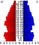
As of the 2000 census,[11] there were 22,486 people, 8,693 households, and 6,302 families residing in the county. The population density was 32 people per square mile (12/km²). There were 9,942 housing units at an average density of 14 per square mile (5/km²). The racial makeup of the county was 96.46% White, 1.05% Black or African American, 0.65% Native American, 0.15% Asian, 0.02% Pacific Islander, 0.39% from other races, and 1.28% from two or more races. 1.21% of the population were Hispanic or Latino of any race.
There were 8,693 households out of which 32.90% had children under the age of 18 living with them, 58.70% were married couples living together, 10.10% had a female householder with no husband present, and 27.50% were non-families. 24.40% of all households were made up of individuals and 12.50% had someone living alone who was 65 years of age or older. The average household size was 2.53 and the average family size was 3.00.
In the county, the population was spread out with 25.90% under the age of 18, 7.50% from 18 to 24, 26.70% from 25 to 44, 23.90% from 45 to 64, and 16.00% who were 65 years of age or older. The median age was 38 years. For every 100 females there were 98.40 males. For every 100 females age 18 and over, there were 94.20 males.
The median income for a household in the county was $28,344, and the median income for a family was $33,732. Males had a median income of $24,472 versus $18,681 for females. The per capita income for the county was $14,527. About 11.40% of families and 15.40% of the population were below the poverty line, including 18.20% of those under age 18 and 19.60% of those age 65 or over.
Government
Over the past few election cycles, Logan County has trended heavily towards the GOP. The last Democrat (as of 2016) to carry this county was Bill Clinton in 1996.
| Year | GOP | Dem | Others |
|---|---|---|---|
| 2016 | 72.54% 5,746 | 21.65% 1,715 | 5.80% 460 |
| 2012 | 69.28% 5,079 | 27.40% 2,009 | 3.31% 243 |
| 2008 | 67.66% 5,350 | 28.91% 2,286 | 3.43% 271 |
| 2004 | 59.36% 5,076 | 39.31% 3,361 | 1.33% 114 |
| 2000 | 55.42% 4,487 | 40.55% 3,283 | 4.03% 326 |
| 1996 | 37.07% 2,966 | 47.89% 3,832 | 15.05% 1,204 |
| 1992 | 39.23% 3,408 | 45.99% 3,995 | 14.78% 1,284 |
| 1988 | 62.87% 2,203 | 35.79% 1,254 | 1.34% 47 |
| 1984 | 63.14% 5,663 | 35.75% 3,206 | 1.11% 100 |
| 1980 | 50.61% 4,511 | 45.98% 4,098 | 3.41% 304 |
| 1976 | 35.07% 2,909 | 64.06% 5,313 | 0.87% 72 |
| 1972 | 71.42% 4,964 | 28.14% 1,956 | 0.43% 30 |
| 1968 | 36.02% 2,341 | 30.74% 1,998 | 33.24% 2,160 |
| 1964 | 38.42% 2,265 | 61.13% 3,604 | 0.46% 27 |
| 1960 | 42.28% 2,014 | 55.33% 2,636 | 2.39% 114 |
| 1956 | 47.17% 2,081 | 52.29% 2,307 | 0.54% 24 |
| 1952 | 44.85% 2,103 | 54.75% 2,567 | 0.41% 19 |
| 1948 | 28.26% 902 | 66.73% 2,130 | 5.01% 160 |
| 1944 | 35.98% 1,279 | 63.83% 2,269 | 0.20% 7 |
| 1940 | 27.34% 1,065 | 72.66% 2,831 | 0.00% 0 |
| 1936 | 22.38% 770 | 77.41% 2,663 | 0.20% 7 |
| 1932 | 20.32% 645 | 78.54% 2,493 | 1.13% 36 |
| 1928 | 42.42% 1,455 | 57.35% 1,967 | 0.23% 8 |
| 1924 | 32.06% 937 | 49.85% 1,457 | 18.10% 529 |
| 1920 | 49.51% 1,871 | 48.69% 1,840 | 1.80% 68 |
| 1916 | 36.96% 1,183 | 63.04% 2,018 | 0.00% 0 |
| 1912 | 12.98% 333 | 51.40% 1,319 | 35.62% 914 |
| 1908 | 38.65% 1,151 | 57.62% 1,716 | 3.73% 111 |
| 1904 | 43.92% 1,007 | 53.95% 1,237 | 2.14% 49 |
| 1900 | 34.88% 848 | 64.05% 1,557 | 1.07% 26 |
| 1896 | 34.51% 946 | 65.16% 1,786 | 0.33% 9 |
Communities
Cities
- Booneville (county seat)
- Magazine
- Paris (county seat)
- Ratcliff
- Scranton
Census-designated place
Unincorporated communities
Townships
Townships in Arkansas are the divisions of a county. Each township includes unincorporated areas; some may have incorporated cities or towns within part of their boundaries. Arkansas townships have limited purposes in modern times. However, the United States Census does list Arkansas population based on townships (sometimes referred to as "county subdivisions" or "minor civil divisions"). Townships are also of value for historical purposes in terms of genealogical research. Each town or city is within one or more townships in an Arkansas county based on census maps and publications. The townships of Logan County are listed below; listed in parentheses are the cities, towns, and/or census-designated places that are fully or partially inside the township. [13][14]
- Barber
- Blue Mountain (Blue Mountain)
- Boone (Booneville)
- Cane Creek
- Cauthron
- Clark (Subiaco)
- Delaware
- Driggs
- Ellsworth
- Johnson
- Logan
- Mountain
- Petit Jean
- Reveilee (Magazine)
- River (Morrison Bluff, Scranton)
- Roseville
- Shoal Creek (CDP New Blaine)
- Short Mountain (Paris)
- Six Mile (Caulksville, Ratcliff)
- Sugar Creek
- Tomlinson
- Washburn
Notable residents
- Katharine Anthony, American biographer
- James Bridges, born in Paris, Arkansas, screenwriter and film director
- Dizzy Dean, born in Lucas, Arkansas, major league baseball player[15]
- Paul Dean, born in Lucas, Arkansas, brother of Dizzy Dean and major league baseball player[15]
- Jon Eubanks, Republican member of the Arkansas House of Representatives from Paris, Arkansas; a farmer and Certified Public Accountant
- Tom Greenway, actor
- General John P. McConnell, Chief of Staff, USAF
- Robert Johnson, lived in Lucas, Arkansas, at the time of the 1920 census. Renowned Bluesman.
See also
- List of lakes in Logan County, Arkansas
- National Register of Historic Places listings in Logan County, Arkansas
References
- "State & County QuickFacts". United States Census Bureau. Archived from the original on June 7, 2011. Retrieved May 23, 2014.
- "Find a County". National Association of Counties. Retrieved 2011-06-07.
- Acts, Resolutions and Memorials of the General Assembly of the State of Arkansas (Session from November 1 to December 15, 1875 ed.). Little Rock, AR: P.A. Ladue. 1876. pp. 129–131. Retrieved 2012-05-08.
- "2010 Census Gazetteer Files". United States Census Bureau. August 22, 2012. Retrieved August 27, 2015.
- "Population and Housing Unit Estimates". Retrieved September 28, 2019.
- "U.S. Decennial Census". United States Census Bureau. Retrieved August 27, 2015.
- "Historical Census Browser". University of Virginia Library. Retrieved August 27, 2015.
- Forstall, Richard L., ed. (March 27, 1995). "Population of Counties by Decennial Census: 1900 to 1990". United States Census Bureau. Retrieved August 27, 2015.
- "Census 2000 PHC-T-4. Ranking Tables for Counties: 1990 and 2000" (PDF). United States Census Bureau. April 2, 2001. Retrieved August 27, 2015.
- Based on 2000 census data
- "U.S. Census website". United States Census Bureau. Retrieved 2011-05-14.
- "Dave Leip's Atlas of U.S. Presidential Elections". Retrieved November 18, 2016.
- 2011 Boundary and Annexation Survey (BAS): Logan County, AR (PDF) (Map). U. S. Census Bureau. Archived from the original (PDF) on 2012-10-19. Retrieved 2011-08-24.
- "Arkansas: 2010 Census Block Maps - County Subdivision". United States Census Bureau. Retrieved May 29, 2014.
- Reichler, Joseph L., ed. (1979) [1969]. The Baseball Encyclopedia (4th ed.). New York: Macmillan Publishing. ISBN 0-02-578970-8.
Places adjacent to Logan County, Arkansas | ||||||||||
|---|---|---|---|---|---|---|---|---|---|---|
| ||||||||||
Municipalities and communities of Logan County, Arkansas, United States | ||
|---|---|---|
| Cities | Map of Arkansas highlighting Logan County | |
| Towns | ||
| CDP | ||
| Unincorporated communities | ||

| Authority control |
|
|---|