Cross County, Arkansas
Cross County is a county located in the U.S. state of Arkansas. As of the 2010 census, the population was 17,870.[1] The county seat is Wynne.[2] Cross County is Arkansas's 53rd county, formed on 15 November 1862 and named for Confederate Colonel David C. Cross, a political leader in the area.
Cross County | |
|---|---|
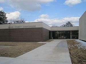 Courthouse in Wynne | |
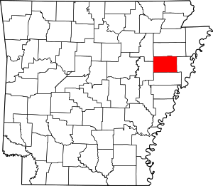 Location within the U.S. state of Arkansas | |
 Arkansas's location within the U.S. | |
| Coordinates: 35°17′30″N 90°46′24″W | |
| Country | |
| State | |
| Founded | November 15, 1862 |
| Named for | David C. Cross |
| Seat | Wynne |
| Largest city | Wynne |
| Area | |
| • Total | 622 sq mi (1,610 km2) |
| • Land | 616 sq mi (1,600 km2) |
| • Water | 5.9 sq mi (15 km2) 1.0%% |
| Population (2010) | |
| • Total | 17,870 |
| • Estimate (2019) | 16,419 |
| • Density | 29/sq mi (11/km2) |
| Time zone | UTC−6 (Central) |
| • Summer (DST) | UTC−5 (CDT) |
| Congressional district | 1st |
| Website | crosscountyar |
Geography
According to the U.S. Census Bureau, the county has a total area of 622 square miles (1,610 km2), of which 616 square miles (1,600 km2) is land and 5.9 square miles (15 km2) (1.0%) is water.[3]
Major highways


Adjacent counties
- Poinsett County (north)
- Crittenden County (east)
- St. Francis County (south)
- Woodruff County (west)
- Jackson County (northwest)
Demographics
| Historical population | |||
|---|---|---|---|
| Census | Pop. | %± | |
| 1870 | 3,915 | — | |
| 1880 | 5,050 | 29.0% | |
| 1890 | 7,693 | 52.3% | |
| 1900 | 11,051 | 43.7% | |
| 1910 | 14,042 | 27.1% | |
| 1920 | 18,579 | 32.3% | |
| 1930 | 25,723 | 38.5% | |
| 1940 | 26,046 | 1.3% | |
| 1950 | 24,757 | −4.9% | |
| 1960 | 19,551 | −21.0% | |
| 1970 | 19,783 | 1.2% | |
| 1980 | 20,434 | 3.3% | |
| 1990 | 19,225 | −5.9% | |
| 2000 | 19,526 | 1.6% | |
| 2010 | 17,870 | −8.5% | |
| Est. 2019 | 16,419 | [4] | −8.1% |
| U.S. Decennial Census[5] 1790–1960[6] 1900–1990[7] 1990–2000[8] 2010–2016[1] | |||
At the 2000 census,[10] there were 19,526 people, 7,391 household, and 5,447 families residing in the county. The population density was 32 per square mile (12/km²). There were 8,030 housing units at an average density of 13 per square mile (5/km²). The racial makeup of the county was 74.80% White, 23.70% Black or African American, 0.23% Native American, 0.31% Asian, 0.01% Pacific Islander, 0.21% from other races, and 0.74% from two or more races. 0.93% of the population were Hispanic or Latino of any race.
There were 7,391 households of which 34.70% had children under the age of 18 living with them, 55.20% were married couples living together, 14.10% had a female householder with no husband present, and 26.30% were non-families. 23.50% of all households were made up of individuals and 11.10% had someone living alone who was 65 years of age or older. The average household size was 2.60 and the average family size was 3.07.
27.80% of the population were under the age of 18, 8.50% from 18 to 24, 27.40% from 25 to 44, 22.60% from 45 to 64, and 13.70% who were 65 years of age or older. The median age was 36 years. For every 100 females there were 94.00 males. For every 100 females age 18 and over, there were 89.40 males.
The median household income was $29,362 and the median family income was $34,044. Males had a median income of $27,880 and females $20,133. The per capita income for the county was $15,726. About 16.40% of families and 19.90% of the population were below the poverty line, including 27.90% of those under age 18 and 17.50% of those age 65 or over.
Government
Formerly a strongly Democratic county, it has voted Republican by increasing margins in every election since 2004.
| Year | GOP | Dem | Others |
|---|---|---|---|
| 2016 | 66.69% 4,584 | 29.08% 1,999 | 4.24% 291 |
| 2012 | 63.90% 4,269 | 34.11% 2,279 | 1.99% 133 |
| 2008 | 61.61% 4,393 | 36.19% 2,580 | 2.20% 157 |
| 2004 | 54.62% 3,864 | 44.32% 3,135 | 1.06% 75 |
| 2000 | 48.80% 3,033 | 49.81% 3,096 | 1.38% 86 |
| 1996 | 32.47% 2,000 | 58.94% 3,631 | 8.58% 529 |
| 1992 | 32.97% 2,303 | 58.09% 4,058 | 8.95% 625 |
| 1988 | 51.29% 3,186 | 48.12% 2,989 | 0.60% 37 |
| 1984 | 59.04% 3,917 | 40.71% 2,701 | 0.26% 17 |
| 1980 | 44.59% 2,895 | 53.47% 3,471 | 1.94% 126 |
| 1976 | 31.11% 1,909 | 68.40% 4,198 | 0.49% 30 |
| 1972 | 72.78% 3,743 | 23.74% 1,221 | 3.48% 179 |
| 1968 | 19.16% 1,093 | 27.26% 1,555 | 53.58% 3,056 |
| 1964 | 46.88% 2,147 | 52.86% 2,421 | 0.26% 12 |
| 1960 | 35.60% 1,287 | 57.76% 2,088 | 6.64% 240 |
| 1956 | 34.42% 1,176 | 63.36% 2,165 | 2.22% 76 |
| 1952 | 38.28% 1,461 | 61.41% 2,344 | 0.31% 12 |
| 1948 | 9.40% 213 | 48.57% 1,100 | 42.03% 952 |
| 1944 | 20.71% 452 | 79.01% 1,724 | 0.27% 6 |
| 1940 | 14.00% 285 | 85.80% 1,746 | 0.20% 4 |
| 1936 | 7.40% 133 | 91.49% 1,644 | 1.11% 20 |
| 1932 | 4.02% 87 | 95.47% 2,066 | 0.51% 11 |
| 1928 | 20.12% 324 | 79.63% 1,282 | 0.25% 4 |
| 1924 | 21.08% 192 | 68.61% 625 | 10.32% 94 |
| 1920 | 34.00% 457 | 62.87% 845 | 3.13% 42 |
| 1916 | 21.37% 252 | 78.63% 927 | 0.00% 0 |
| 1912 | 26.71% 293 | 44.76% 491 | 28.53% 313 |
| 1908 | 39.83% 507 | 55.38% 705 | 4.79% 61 |
| 1904 | 32.79% 321 | 64.35% 630 | 2.86% 28 |
| 1900 | 32.74% 312 | 66.95% 638 | 0.31% 3 |
| 1896 | 19.77% 224 | 80.14% 908 | 0.09% 1 |
Communities
Cities
- Cherry Valley
- Hickory Ridge
- Parkin
- Wynne (county seat)
Townships
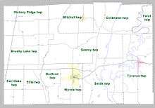
Townships in Arkansas are the divisions of a county. Each township includes unincorporated areas; some may have incorporated cities or towns within part of their boundaries. Arkansas townships have limited purposes in modern times. However, the United States Census does list Arkansas population based on townships (sometimes referred to as "county subdivisions" or "minor civil divisions"). Townships are also of value for historical purposes in terms of genealogical research. Each town or city is within one or more townships in an Arkansas county based on census maps and publications. The townships of Cross County are listed below; listed in parentheses are the cities, towns, and/or census-designated places that are fully or partially inside the township. [12][13]
- Bedford (small part of Wynne)
- Birdeye
- Brushy Lake
- Coldwater
- Ellis
- Fair Oaks
- Hickory Ridge (Hickory Ridge)
- Mitchell (Cherry Valley)
- Searcy
- Smith
- Smithdale
- Twist
- Tyronza (Parkin)
- Wynne (most of Wynne)
See also
- List of lakes in Cross County, Arkansas
- National Register of Historic Places listings in Cross County, Arkansas
References
| Wikimedia Commons has media related to Cross County, Arkansas. |
- "State & County QuickFacts". United States Census Bureau. Archived from the original on July 9, 2011. Retrieved May 20, 2014.
- "Find a County". National Association of Counties. Archived from the original on May 31, 2011. Retrieved June 7, 2011.
- "2010 Census Gazetteer Files". United States Census Bureau. August 22, 2012. Retrieved August 25, 2015.
- "Population and Housing Unit Estimates". Retrieved September 28, 2019.
- "U.S. Decennial Census". United States Census Bureau. Retrieved August 25, 2015.
- "Historical Census Browser". University of Virginia Library. Retrieved August 25, 2015.
- Forstall, Richard L., ed. (March 27, 1995). "Population of Counties by Decennial Census: 1900 to 1990". United States Census Bureau. Retrieved August 25, 2015.
- "Census 2000 PHC-T-4. Ranking Tables for Counties: 1990 and 2000" (PDF). United States Census Bureau. April 2, 2001. Retrieved August 25, 2015.
- Based on 2000 census data
- "U.S. Census website". United States Census Bureau. Retrieved May 14, 2011.
- "Dave Leip's Atlas of U.S. Presidential Elections". Retrieved November 18, 2016.
- 2011 Boundary and Annexation Survey (BAS): Cross County, AR (PDF) (Map). U. S. Census Bureau. Archived from the original (PDF) on October 19, 2012. Retrieved August 6, 2011.
- "Arkansas: 2010 Census Block Maps - County Subdivision". United States Census Bureau. Retrieved May 28, 2014.
External links
Places adjacent to Cross County, Arkansas | ||||||||||
|---|---|---|---|---|---|---|---|---|---|---|
| ||||||||||
Municipalities and communities of Cross County, Arkansas, United States | ||
|---|---|---|
| Cities | Map of Arkansas highlighting Cross County | |
| Unincorporated communities | ||

| Authority control |
|
|---|