St. Francis County, Arkansas
St. Francis County is a county located in the U.S. state of Arkansas. As of the 2010 census, the population was 28,258.[1] The county seat is Forrest City.[2]
Saint Francis County | |
|---|---|
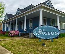 St. Francis County Museum in Forrest City, Arkansas. | |
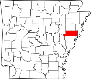 Location within the U.S. state of Arkansas | |
 Arkansas's location within the U.S. | |
| Coordinates: 35°01′36″N 90°42′15″W | |
| Country | |
| State | |
| Founded | October 13, 1827 |
| Named for | St. Francis River |
| Seat | Forrest City |
| Largest city | Forrest City |
| Area | |
| • Total | 643 sq mi (1,670 km2) |
| • Land | 635 sq mi (1,640 km2) |
| • Water | 7.7 sq mi (20 km2) 1.2%% |
| Population (2010) | |
| • Total | 28,258 |
| • Estimate (2019) | 24,994 |
| • Density | 44/sq mi (17/km2) |
| Time zone | UTC−6 (Central) |
| • Summer (DST) | UTC−5 (CDT) |
| Congressional district | 1st |
St. Francis County comprises the Forrest City, AR Micropolitan Statistical Area, which is also included in the Memphis-Forrest City, TN-MS-AR Combined Statistical Area.
A portion of St. Francis County is represented in the Arkansas State Senate by the Republican Ronald R. Caldwell
History
The county was formed on October 13, 1827, and named for the St. Francis River.
Geography
According to the U.S. Census Bureau, the county has a total area of 643 square miles (1,670 km2), of which 635 square miles (1,640 km2) is land and 7.7 square miles (20 km2) (1.2%) is water.[3]
Major highways
.svg.png)


Adjacent counties
- Cross County (north)
- Crittenden County (east)
- Lee County (south)
- Monroe County (southwest)
- Woodruff County (northwest)
Demographics
| Historical population | |||
|---|---|---|---|
| Census | Pop. | %± | |
| 1830 | 1,505 | — | |
| 1840 | 2,499 | 66.0% | |
| 1850 | 4,479 | 79.2% | |
| 1860 | 8,672 | 93.6% | |
| 1870 | 6,714 | −22.6% | |
| 1880 | 8,389 | 24.9% | |
| 1890 | 13,543 | 61.4% | |
| 1900 | 17,157 | 26.7% | |
| 1910 | 22,548 | 31.4% | |
| 1920 | 28,385 | 25.9% | |
| 1930 | 33,394 | 17.6% | |
| 1940 | 36,043 | 7.9% | |
| 1950 | 36,841 | 2.2% | |
| 1960 | 33,303 | −9.6% | |
| 1970 | 30,799 | −7.5% | |
| 1980 | 30,858 | 0.2% | |
| 1990 | 28,497 | −7.7% | |
| 2000 | 29,329 | 2.9% | |
| 2010 | 28,258 | −3.7% | |
| Est. 2019 | 24,994 | [4] | −11.6% |
| U.S. Decennial Census[5] 1790–1960[6] 1900–1990[7] 1990–2000[8] 2010–2016[1] | |||
As of the 2010 census, there were 28,258 people living in the county. 51.9% were Black or African American, 44.2% White, 0.5% Native American, 0.5% Asian, 1.4% of some other race and 1.5% of two or more races. 4.1% were Hispanic or Latino (of any race).
As of the 2000 census,[10] there were 29,329 people, 10,043 households, and 7,230 families living in the county. The population density was 18/km² (46/mi²). There were 11,242 housing units at an average density of 7/km² (18/mi²). The racial makeup of the county was 48.36% White, 49.01% Black or African American, 0.25% Native American, 0.56% Asian, 0.02% Pacific Islander, 0.40% from other races, and 1.40% from two or more races. 4.88% of the population were Hispanic or Latino of any race.
There were 10,043 households out of which 35.30% had children under the age of 18 living with them, 46.90% were married couples living together, 20.80% had a female householder with no husband present, and 28.00% were non-families. 25.10% of all households were made up of individuals and 10.80% had someone living alone who was 65 years of age or older. The average household size was 2.65 and the average family size was 3.17.
In the county, the population was spread out with 27.90% under the age of 18, 9.90% from 18 to 24, 29.10% from 25 to 44, 21.20% from 45 to 64, and 11.90% who were 65 years of age or older. The median age was 34 years. For every 100 females there were 105.60 males. For every 100 females age 18 and over, there were 105.40 males.
The median income for a household in the county was $26,146, and the median income for a family was $30,324. Males had a median income of $28,389 versus $20,578 for females. The per capita income for the county was $12,483. About 23.10% of families and 27.50% of the population were below the poverty line, including 38.70% of those under age 18 and 23.10% of those age 65 or over.
Government and infrastructure
The Federal Bureau of Prisons Federal Correctional Complex, Forrest City is in Forrest City.[11][12]
In presidential elections, St. Francis County generally votes Democratic. It has voted Democratic in every election since 1912, other than 1968, 1972, and 1984.
| Year | GOP | Dem | Others |
|---|---|---|---|
| 2016 | 43.00% 3,195 | 54.25% 4,031 | 2.74% 204 |
| 2012 | 40.28% 3,368 | 58.72% 4,910 | 1.00% 84 |
| 2008 | 41.21% 3,917 | 57.72% 5,486 | 1.07% 102 |
| 2004 | 39.79% 3,815 | 59.28% 5,684 | 0.93% 89 |
| 2000 | 40.18% 3,414 | 58.69% 4,986 | 1.13% 96 |
| 1996 | 29.19% 2,523 | 64.35% 5,562 | 6.46% 559 |
| 1992 | 30.93% 3,289 | 61.57% 6,548 | 7.50% 798 |
| 1988 | 47.86% 4,298 | 51.85% 4,656 | 0.29% 26 |
| 1984 | 52.10% 5,378 | 47.14% 4,866 | 0.76% 78 |
| 1980 | 42.77% 4,485 | 55.46% 5,816 | 1.77% 186 |
| 1976 | 34.59% 3,639 | 65.12% 6,851 | 0.29% 30 |
| 1972 | 65.95% 5,692 | 30.98% 2,674 | 3.07% 265 |
| 1968 | 17.58% 1,608 | 35.91% 3,284 | 46.51% 4,254 |
| 1964 | 47.98% 3,377 | 51.88% 3,651 | 0.14% 10 |
| 1960 | 39.53% 1,786 | 53.83% 2,432 | 6.64% 300 |
| 1956 | 44.87% 1,884 | 50.35% 2,114 | 4.79% 201 |
| 1952 | 42.08% 1,792 | 57.90% 2,466 | 0.02% 1 |
| 1948 | 8.26% 178 | 46.91% 1,011 | 44.83% 966 |
| 1944 | 21.16% 446 | 78.46% 1,654 | 0.38% 8 |
| 1940 | 10.14% 192 | 88.23% 1,671 | 1.64% 31 |
| 1936 | 4.59% 94 | 94.72% 1,938 | 0.68% 14 |
| 1932 | 5.49% 130 | 92.56% 2,191 | 1.94% 46 |
| 1928 | 30.82% 617 | 68.73% 1,376 | 0.45% 9 |
| 1924 | 29.52% 433 | 66.26% 972 | 4.23% 62 |
| 1920 | 40.82% 903 | 56.60% 1,252 | 2.58% 57 |
| 1916 | 29.15% 395 | 70.85% 960 | 0.00% 0 |
| 1912 | 29.19% 296 | 55.52% 563 | 15.29% 155 |
| 1908 | 51.12% 755 | 41.91% 619 | 6.97% 103 |
| 1904 | 43.29% 577 | 55.29% 737 | 1.43% 19 |
| 1900 | 51.84% 703 | 46.76% 634 | 1.40% 19 |
| 1896 | 29.35% 455 | 70.13% 1,087 | 0.52% 8 |
Communities
Cities
- Forrest City (county seat)
- Madison
Townships
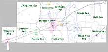
Townships in Arkansas are the divisions of a county. Each township includes unincorporated areas; some may have incorporated cities or towns within part of their boundaries. Arkansas townships have limited purposes in modern times. However, the United States Census does list Arkansas population based on townships (sometimes referred to as "county subdivisions" or "minor civil divisions"). Townships are also of value for historical purposes in terms of genealogical research. Each town or city is within one or more townships in an Arkansas county based on census maps and publications. The townships of St. Francis County are listed below; listed in parentheses are the cities, towns, and/or census-designated places that are fully or partially inside the township. [14][15]
- Black Fish
- Franks (small part of Forrest City)
- Garland (Hughes)
- Goodwin
- Griggs (Widener)
- Heth
- Johnson
- L'Anguille
- Madison (most of Forrest City, Madison
- Prairie (Palestine
- Telico (Caldwell, Colt, small part of Forrest City)
- Wheatley (most of Wheatley)
Notable people
- Al Green, American singer, was born in Forrest City, St. Francis County.
- Charlie Rich, American country singer, was born in Colt, in St. Francis County.
- Sonny Liston, World heavyweight boxing champion, was born in Johnson Township, St. Francis County.
- Mark R. Martin, current Secretary of State of Arkansas, was raised near Blackfish Lake and graduated from Hughes High School in 1986.
See also
- List of lakes in St. Francis County, Arkansas
- National Register of Historic Places listings in St. Francis County, Arkansas
References
- "State & County QuickFacts". United States Census Bureau. Retrieved May 19, 2014.
- "Find a County". National Association of Counties. Retrieved 2011-06-07.
- "2010 Census Gazetteer Files". United States Census Bureau. August 22, 2012. Retrieved August 27, 2015.
- "Population and Housing Unit Estimates". Retrieved September 28, 2019.
- "U.S. Decennial Census". United States Census Bureau. Retrieved August 27, 2015.
- "Historical Census Browser". University of Virginia Library. Retrieved August 27, 2015.
- Forstall, Richard L., ed. (March 27, 1995). "Population of Counties by Decennial Census: 1900 to 1990". United States Census Bureau. Retrieved August 27, 2015.
- "Census 2000 PHC-T-4. Ranking Tables for Counties: 1990 and 2000" (PDF). United States Census Bureau. April 2, 2001. Retrieved August 27, 2015.
- Based on 2000 census data
- "U.S. Census website". United States Census Bureau. Retrieved 2011-05-14.
- "Forrest City city, Arkansas." U.S. Census Bureau. Retrieved on May 1, 2011.
- "FCI Forrest City Medium Contact Information." Federal Bureau of Prisons. Retrieved on May 1, 2011. "FCI FORREST CITY MEDIUM FEDERAL CORRECTIONAL INSTITUTION 1400 DALE BUMPERS ROAD FORREST CITY, AR 72335"
- "Dave Leip's Atlas of U.S. Presidential Elections". Retrieved November 18, 2016.
- 2011 Boundary and Annexation Survey (BAS): St. Francis County, AR (PDF) (Map). U. S. Census Bureau. Archived from the original (PDF) on 2012-10-19. Retrieved 2011-08-06.
- "Arkansas: 2010 Census Block Maps - County Subdivision". United States Census Bureau. Retrieved May 29, 2014.
External links
- St. Francis county official website
- St. Francis, Arkansas entry on the Encyclopedia of Arkansas History & Culture
Places adjacent to St. Francis County, Arkansas | ||||||||||
|---|---|---|---|---|---|---|---|---|---|---|
| ||||||||||
Municipalities and communities of St. Francis County, Arkansas, United States | ||
|---|---|---|
| Cities | Map of Arkansas highlighting St. Francis County | |
| Towns | ||
| Unincorporated communities | ||
| Footnotes | ‡This populated place also has portions in an adjacent county or counties | |

| Authority control |
|
|---|