Fulton County, Arkansas
Fulton County is a county located in the U.S. state of Arkansas. As of the 2010 census, the population was 12,245.[1] The county seat is Salem.[2] Fulton County was formed on December 21, 1842, and named for William Fulton,[3] the last governor of the Arkansas Territory. It is an alcohol prohibition or dry county.
Fulton County | |
|---|---|
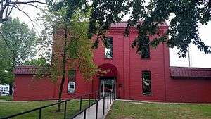 Fulton County Courthouse in Salem | |
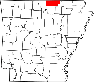 Location within the U.S. state of Arkansas | |
 Arkansas's location within the U.S. | |
| Coordinates: 36°23′19″N 91°48′52″W | |
| Country | |
| State | |
| Founded | December 21, 1842 |
| Named for | William Fulton |
| Seat | Salem |
| Largest city | Salem |
| Area | |
| • Total | 620 sq mi (1,600 km2) |
| • Land | 618 sq mi (1,600 km2) |
| • Water | 2.1 sq mi (5 km2) 0.3%% |
| Population (2010) | |
| • Total | 12,245 |
| • Estimate (2019) | 12,477 |
| • Density | 20/sq mi (7.6/km2) |
| Time zone | UTC−6 (Central) |
| • Summer (DST) | UTC−5 (CDT) |
| Congressional district | 1st |
| Website | fulton |
Geography
According to the U.S. Census Bureau, the county has a total area of 620 square miles (1,600 km2), of which 618 square miles (1,600 km2) is land and 2.1 square miles (5.4 km2) (0.3%) is water.[4]
Major highways
Adjacent counties
- Ozark County, Missouri (northwest)
- Howell County, Missouri (north)
- Oregon County, Missouri (northeast)
- Sharp County (east)
- Izard County (south)
- Baxter County (west)
Demographics
| Historical population | |||
|---|---|---|---|
| Census | Pop. | %± | |
| 1850 | 1,819 | — | |
| 1860 | 4,024 | 121.2% | |
| 1870 | 4,843 | 20.4% | |
| 1880 | 6,720 | 38.8% | |
| 1890 | 10,984 | 63.5% | |
| 1900 | 12,917 | 17.6% | |
| 1910 | 12,193 | −5.6% | |
| 1920 | 11,182 | −8.3% | |
| 1930 | 10,834 | −3.1% | |
| 1940 | 10,253 | −5.4% | |
| 1950 | 9,187 | −10.4% | |
| 1960 | 6,657 | −27.5% | |
| 1970 | 7,699 | 15.7% | |
| 1980 | 9,975 | 29.6% | |
| 1990 | 10,037 | 0.6% | |
| 2000 | 11,642 | 16.0% | |
| 2010 | 12,245 | 5.2% | |
| Est. 2019 | 12,477 | [5] | 1.9% |
| U.S. Decennial Census[6] 1790–1960[7] 1900–1990[8] 1990–2000[9] 2010–2016[1] 2018[10] | |||
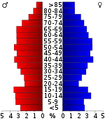
As of the 2000 census,[12] there were 11,642 people, 4,810 households, and 3,511 families residing in the county. The population density was 19 people per square mile (7/km²). There were 5,973 housing units at an average density of 10 per square mile (4/km²). The racial makeup of the county was 97.67% White, 0.20% Black or African American, 0.67% Native American, 0.21% Asian, 0.06% from other races, and 1.19% from two or more races. 0.53% of the population were Hispanic or Latino of any race.
There were 4,810 households out of which 27.40% had children under the age of 18 living with them, 62.40% were married couples living together, 7.80% had a female householder with no husband present, and 27.00% were non-families. 24.40% of all households were made up of individuals and 12.80% had someone living alone who was 65 years of age or older. The average household size was 2.39 and the average family size was 2.83.
In the county, the population was spread out with 22.80% under the age of 18, 6.40% from 18 to 24, 23.70% from 25 to 44, 27.00% from 45 to 64, and 20.20% who were 65 years of age or older. The median age was 43 years. For every 100 females there were 96.00 males. For every 100 females age 18 and over, there were 93.10 males.
The median income for a household in the county was $25,529, and the median income for a family was $29,952. Males had a median income of $22,213 versus $18,066 for females. The per capita income for the county was $15,712. About 12.70% of families and 16.30% of the population were below the poverty line, including 20.10% of those under age 18 and 12.70% of those age 65 or over.
Government
Over the past few election cycles Fulton county has trended heavily towards the GOP. The last Democrat (as of 2016) to carry the county was Bill Clinton, in 1996.
| Year | GOP | Dem | Others |
|---|---|---|---|
| 2016 | 72.74% 3,471 | 22.36% 1,067 | 4.91% 234 |
| 2012 | 65.21% 2,949 | 32.11% 1,452 | 2.68% 121 |
| 2008 | 57.78% 2,702 | 38.90% 1,819 | 3.31% 155 |
| 2004 | 50.90% 2,522 | 47.83% 2,370 | 1.27% 63 |
| 2000 | 49.56% 2,036 | 48.10% 1,976 | 2.34% 96 |
| 1996 | 31.99% 1,351 | 55.91% 2,361 | 12.10% 511 |
| 1992 | 26.56% 1,258 | 59.69% 2,827 | 13.74% 651 |
| 1988 | 48.47% 1,918 | 51.00% 2,018 | 0.53% 21 |
| 1984 | 55.15% 2,329 | 44.14% 1,864 | 0.71% 30 |
| 1980 | 49.35% 2,101 | 47.85% 2,037 | 2.80% 119 |
| 1976 | 27.94% 1,038 | 71.87% 2,670 | 0.19% 7 |
| 1972 | 67.89% 2,030 | 32.11% 960 | 0.00% 0 |
| 1968 | 36.34% 1,198 | 30.91% 1,019 | 32.76% 1,080 |
| 1964 | 33.09% 846 | 66.64% 1,704 | 0.27% 7 |
| 1960 | 60.95% 1,127 | 38.02% 703 | 1.03% 19 |
| 1956 | 45.12% 799 | 54.09% 958 | 0.79% 14 |
| 1952 | 45.92% 890 | 54.08% 1,048 | 0.00% 0 |
| 1948 | 27.63% 339 | 69.27% 850 | 3.10% 38 |
| 1944 | 44.23% 525 | 55.60% 660 | 0.17% 2 |
| 1940 | 28.15% 333 | 70.84% 838 | 1.01% 12 |
| 1936 | 31.53% 437 | 68.25% 946 | 0.22% 3 |
| 1932 | 16.09% 237 | 83.84% 1,235 | 0.07% 1 |
| 1928 | 42.29% 686 | 57.58% 934 | 0.12% 2 |
| 1924 | 29.00% 292 | 67.33% 678 | 3.67% 37 |
| 1920 | 39.13% 502 | 59.47% 763 | 1.40% 18 |
| 1916 | 26.34% 392 | 73.66% 1,096 | 0.00% 0 |
| 1912 | 34.24% 453 | 44.60% 590 | 21.16% 280 |
| 1908 | 30.96% 366 | 62.69% 741 | 6.35% 75 |
| 1904 | 40.11% 359 | 53.74% 481 | 6.15% 55 |
| 1900 | 28.54% 397 | 70.74% 984 | 0.72% 10 |
| 1896 | 20.88% 333 | 78.93% 1,259 | 0.19% 3 |
Education
Fulton County is the home to several public school districts:
- Mammoth Spring School District, including Mammoth Spring High School.
- Salem School District, including Salem High School.
- Viola School District, including Viola High School.
Communities
Cities
- Ash Flat
- Cherokee Village
- Hardy
- Horseshoe Bend
- Mammoth Spring
- Salem (county seat)
Town
Unincorporated communities
Townships
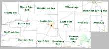
Townships in Arkansas are the divisions of a county. Each township includes unincorporated areas; some may have incorporated cities or towns within part of their boundaries. Arkansas townships have limited purposes in modern times. However, the United States Census does list Arkansas population based on townships (sometimes referred to as "county subdivisions" or "minor civil divisions"). Townships are also of value for historical purposes in terms of genealogical research. Each town or city is within one or more townships in an Arkansas county based on census maps and publications. The townships of Fulton County are listed below; listed in parentheses are the cities, towns, and/or census-designated places that are fully or partially inside the township. [14][15]
| Township | FIPS code | ANSI code (GNIS ID) |
Population center(s) |
Pop. (2010) |
Pop. density (/mi²) |
Pop. density (/km²) |
Total area (mi²) |
Total area (km²) |
Land area (mi²) |
Land area (km²) |
Water area (mi²) |
Water area (km²) |
Geographic coordinates |
|---|---|---|---|---|---|---|---|---|---|---|---|---|---|
| Afton | 05-90006 | 00066571 | part of Hardy | 650 | 17.45 | 6.74 | 37.587 | 97.35 | 37.252 | 96.48 | 0.335 | 0.8676 | 36.379508°N 91.504051°W |
| Benton | 05-90243 | 00066573 | Salem | 2,564 | 43.10 | 16.64 | 59.552 | 154.2 | 59.493 | 154.1 | 0.059 | 0.1528 | 36.372416°N 91.848591°W |
| Big Creek | 05-90258 | 00066574 | 428 | 12.82 | 4.95 | 34.167 | 88.49 | 33.398 | 86.50 | 0.769 | 1.992 | 36.333345°N 92.111645°W | |
| Cleveland | 05-90855 | 00066575 | 514 | 9.44 | 3.65 | 54.677 | 141.6 | 54.450 | 141.0 | 0.227 | 0.5879 | 36.301335°N 92.014618°W | |
| Fulton | 05-91392 | 00066576 | Viola | 1,049 | 22.82 | 8.81 | 46.115 | 119.4 | 45.968 | 119.1 | 0.147 | 0.3807 | 36.388875°N 91.995757°W |
| Mammoth Spring | 05-92361 | 00066577 | Mammoth Spring | 2,035 | 40.35 | 15.58 | 50.584 | 131.0 | 50.430 | 130.6 | 0.154 | 0.3989 | 36.461887°N 91.538778°W |
| Mount Calm | 05-92619 | 00066578 | 207 | 7.78 | 3.0 | 26.627 | 68.96 | 26.611 | 68.92 | 0.016 | 0.04144 | 36.475816°N 91.987814°W | |
| Myatt | 05-92658 | 00066579 | 191 | 5.34 | 2.06 | 35.792 | 92.70 | 35.766 | 92.63 | 0.026 | 0.06734 | 36.377891°N 91.626355°W | |
| Pleasant Ridge | 05-92922 | 00066580 | half of Cherokee Village, small part of Ash Flat | 1,926 | 35.42 | 13.68 | 54.721 | 141.7 | 54.381 | 140.8 | 0.340 | 0.8806 | 36.283387°N 91.642620°W |
| South Fork | 05-93429 | 00066581 | 485 | 11.33 | 4.37 | 42.819 | 110.9 | 42.805 | 110.9 | 0.014 | 0.03626 | 36.397657°N 91.725885°W | |
| Strawberry | 05-93498 | 00066582 | small part of Horseshoe Bend | 742 | 24.28 | 9.38 | 30.591 | 79.23 | 30.558 | 79.14 | 0.033 | 0.08547 | 36.302524°N 91.784817°W |
| Union | 05-93681 | 00066583 | 303 | 13.08 | 5.05 | 23.158 | 59.98 | 23.158 | 59.98 | 0 | 0.000 | 36.290424°N 91.882059°W | |
| Vidette | 05-93798 | 00066584 | 467 | 9.70 | 3.74 | 48.143 | 124.7 | 48.143 | 124.7 | 0 | 0.000 | 36.445552°N 92.100286°W | |
| Washington | 05-93909 | 00066585 | 406 | 10.05 | 3.88 | 40.408 | 104.7 | 40.394 | 104.6 | 0.014 | 0.03626 | 36.463799°N 91.865792°W | |
| Wilson | 05-94086 | 00066587 | 278 | 7.86 | 3.03 | 35.387 | 91.65 | 35.387 | 91.65 | 0 | 0.000 | 36.471176°N 91.699477°W | |
| Source: "Census 2010 U.S. Gazetteer Files: County Subdivisions in Arkansas". U.S. Census Bureau, Geography Division. Archived from the original on 2014-05-28.
Source: "Census 2010 U.S. Gazetteer Files". U.S. Census Bureau, Geography Division. | |||||||||||||
See also
- List of lakes in Fulton County, Arkansas
- National Register of Historic Places listings in Fulton County, Arkansas
References
- "State & County QuickFacts". United States Census Bureau. Retrieved May 20, 2014.
- "Find a County". National Association of Counties. Archived from the original on 2011-05-31. Retrieved 2011-06-07.
- Gannett, Henry (1905). The Origin of Certain Place Names in the United States. Govt. Print. Off. pp. 133.
- "2010 Census Gazetteer Files". United States Census Bureau. August 22, 2012. Retrieved August 26, 2015.
- "Population and Housing Unit Estimates". Retrieved September 28, 2019.
- "U.S. Decennial Census". United States Census Bureau. Retrieved August 26, 2015.
- "Historical Census Browser". University of Virginia Library. Retrieved August 26, 2015.
- Forstall, Richard L., ed. (March 27, 1995). "Population of Counties by Decennial Census: 1900 to 1990". United States Census Bureau. Retrieved August 26, 2015.
- "Census 2000 PHC-T-4. Ranking Tables for Counties: 1990 and 2000" (PDF). United States Census Bureau. April 2, 2001. Retrieved August 26, 2015.
- "Fulton County, Arkansas". United States Census Bureau. Retrieved August 9, 2019.
- Based on 2000 census data
- "U.S. Census website". United States Census Bureau. Retrieved 2011-05-14.
- "Dave Leip's Atlas of U.S. Presidential Elections". Retrieved November 18, 2016.
- 2011 Boundary and Annexation Survey (BAS): Fulton County, AR (PDF) (Map). U. S. Census Bureau. Archived from the original (PDF) on 2012-10-19. Retrieved 2011-08-05.
- "Arkansas: 2010 Census Block Maps - County Subdivision". United States Census Bureau. Retrieved June 28, 2014.
Places adjacent to Fulton County, Arkansas | ||||||||||
|---|---|---|---|---|---|---|---|---|---|---|
| ||||||||||
Municipalities and communities of Fulton County, Arkansas, United States | ||
|---|---|---|
| Cities | Map of Arkansas highlighting Fulton County | |
| Town | ||
| Unincorporated communities | ||
| Footnotes | ‡This populated place also has portions in an adjacent county or counties | |

| Authority control |
|
|---|