Arkansas Highway 113
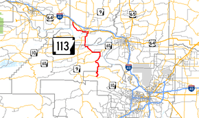
Arkansas Highway 113 (AR 113 and Hwy. 113) is a north–south state highway that runs in Central Arkansas. The route runs 29.48 miles (47.44 km) from Arkansas Highway 10 to Morrilton.[1] This also gives access to some rural areas west of Morrilton. It runs through Pulaski, Perry, and Conway Counties. It contains no spur of business routes.[1]
| ||||
|---|---|---|---|---|
 | ||||
| Route information | ||||
| Maintained by AHTD | ||||
| Length | 29.48 mi[1] (47.44 km) | |||
| Existed | 1926–present | |||
| Major junctions | ||||
| South end | ||||
| North end | ||||
| Location | ||||
| Counties | Pulaski, Perry, Conway | |||
| Highway system | ||||
| ||||

Route description
AR 113 begins near Lake Maumelle west of Little Rock.[2] It runs north 5.8 miles (9.3 km) to Wye where AR 300 forms a concurrency. The route then continues heading north for 3.2 miles (5.1 km) to Pleasant Valley where AR 300 continues west. AR 113 continues heading north and heads through Bigelow, Arkansas and then joins with AR 60 west to Houston.[3]
In Houston, AR 113 departs AR 60 and heads north again to where it meets AR 9 south of the Arkansas River. It crosses the Arkansas River into Morrilton. There, it joins US 64 for a short time then departs west to run on its own course parallel to that highway. It joins back up with US 64 near Blackwell.[4]
History
Arkansas Highway 113 was designated as part of the original 1926 state highways a route from Leola to Poyen. By 1928, a second segment was created from AR 10 to Bigelow and this segment was labeled 'impassable'.[5] Between 1943 and 1945, the highway was extended to Morrilton.[6] In 1957, the segment from Leola to Poyen was renumbered to AR 229. The segment along US 64 was added in 1963.[7]
Major intersections
| County | Location | mi[2][3][4] | km | Destinations | Notes |
|---|---|---|---|---|---|
| Pulaski | | 0.0 | 0.0 | Southern terminus | |
| Wye | 5.8 | 9.3 | |||
| Perry | Pleasant Valley | 9.0 | 14.5 | ||
| | 13.9 | 22.4 | |||
| Houston | 0.0 | 0.0 | |||
| Conway | Oppelo | 6.3 | 10.1 | Eastern terminus of AR 154 | |
| 7.8 | 12.6 | ||||
| Morrilton | 0.0 | 0.0 | |||
| Blackwell | 7.8 | 12.6 | Northern terminus | ||
| 1.000 mi = 1.609 km; 1.000 km = 0.621 mi | |||||
See also
References
- "[Arkansas] State Highways 2009 (Database)." April 2010. AHTD: Planning and Research Division. Database. Archived 2011-07-07 at the Wayback Machine Retrieved March 20, 2011.
- General Highway Map - Pulaski County, Arkansas (PDF) (Map) (8-1-2009 ed.). Arkansas State Highway and Transportation Department. Retrieved March 20, 2011.
- General Highway Map - Perry County, Arkansas (PDF) (Map) (1-4-2008 ed.). Arkansas State Highway and Transportation Department. Retrieved March 20, 2011.
- General Highway Map - Conway County, Arkansas (PDF) (Map) (1-2-2008 ed.). Arkansas State Highway and Transportation Department. Retrieved March 20, 2011.
- Map of State of Arkansas showing System of State Highways (Map) (September 1, 1928 ed.). [Arkansas] State Highway Department. Archived from the original on October 13, 2011. Retrieved March 20, 2011.
- Highway Map of Arkansas (Map). Arkansas State Highway Department. Archived from the original on July 7, 2011. Retrieved March 20, 2011.
- Map of State Highway System of Arkansas (Map). Arkansas State Highway Commission. Archived from the original on March 28, 2012. Retrieved March 20, 2011.
External links
![]()