Greene County, Arkansas
Greene County is a county located in the U.S. state of Arkansas. As of the 2010 census, the population was 42,090.[1] The county seat is Paragould,[2] which sits atop Crowley's Ridge.
Greene County | |
|---|---|
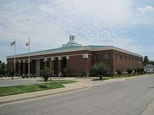 Courthouse in Paragould | |
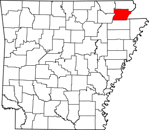 Location within the U.S. state of Arkansas | |
 Arkansas's location within the U.S. | |
| Coordinates: 36°06′21″N 90°33′41″W | |
| Country | |
| State | |
| Founded | November 5, 1833 |
| Named for | Nathanael Greene |
| Seat | Paragould |
| Largest city | Paragould |
| Area | |
| • Total | 580 sq mi (1,500 km2) |
| • Land | 578 sq mi (1,500 km2) |
| • Water | 1.9 sq mi (5 km2) 0.3%% |
| Time zone | UTC−6 (Central) |
| • Summer (DST) | UTC−5 (CDT) |
| Congressional district | 1st |
| Website | county |
Greene County comprises the Paragould, AR Micropolitan Statistical Area, which is also included in the Jonesboro–Paragould, AR Combined Statistical Area.
History
The first settler in the area was Benjamin Crowley, who arrived from Kentucky in 1821 and made his home about 12 miles (19 km) west of Paragould.
Greene County was formed on 5 November 1833 out of portions of Lawrence County and originally contained parts of present Clay and Craighead counties. The county was named for Revolutionary War hero Nathanael Greene. The first county seat was in Benjamin Crowley's home. By 1836, when Arkansas became a state, the county seat was located in a settlement called "Paris" (not to be confused with present-day Paris, Arkansas).
In 1848 a national highway was made through the area, and the county seat was moved to Gainesville, which had a reputation as rather lawless. The seat remained there until 1883, when it was transferred to the new town of Paragould. The people in Gainesville opposed the move, and shots reportedly were fired, since tempers were high. The courthouse was built in 1888 and survives in downtown Paragould.
In the early 20th century, Clay, Greene, and Craighead counties had policies forbidding African Americans from living in the area.[3]
Geography
According to the U.S. Census Bureau, the county has a total area of 580 square miles (1,500 km2), of which 578 square miles (1,500 km2) is land and 1.9 square miles (4.9 km2) (0.3%) is water.[4]
Major highways


Adjacent counties
- Clay County (north)
- Dunklin County, Missouri (east)
- Craighead County (south)
- Lawrence County (southwest)
- Randolph County (northwest)
Demographics
| Historical population | |||
|---|---|---|---|
| Census | Pop. | %± | |
| 1840 | 1,586 | — | |
| 1850 | 2,593 | 63.5% | |
| 1860 | 5,843 | 125.3% | |
| 1870 | 7,573 | 29.6% | |
| 1880 | 7,480 | −1.2% | |
| 1890 | 12,908 | 72.6% | |
| 1900 | 16,979 | 31.5% | |
| 1910 | 23,852 | 40.5% | |
| 1920 | 26,105 | 9.4% | |
| 1930 | 26,127 | 0.1% | |
| 1940 | 30,204 | 15.6% | |
| 1950 | 29,149 | −3.5% | |
| 1960 | 25,198 | −13.6% | |
| 1970 | 24,765 | −1.7% | |
| 1980 | 30,744 | 24.1% | |
| 1990 | 31,804 | 3.4% | |
| 2000 | 37,331 | 17.4% | |
| 2010 | 42,090 | 12.7% | |
| Est. 2019 | 45,325 | [5] | 7.7% |
| U.S. Decennial Census[6] 1790–1960[7] 1900–1990[8] 1990–2000[9] 2010–2016[1] | |||
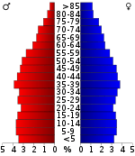
As of the 2010 census, there were 42,090 people living in the county. The racial makeup of the county was 95.4% White, 0.6% Black, 0.5% Native American, 0.3% Asian, <0.1% Pacific Islander, <0.1% from some other race and 1.1% from two or more races. 2.1% were Hispanic or Latino of any race.
As of the 2000 census,[11] there were 37,331 people, 14,750 households, and 10,708 families living in the county. The population density was 65 people per square mile (25/km²). There were 16,161 housing units at an average density of 28 per square mile (11/km²). The racial makeup of the county was 97.45% White, 0.13% Black or African American, 0.42% Native American, 0.17% Asian, 0.02% Pacific Islander, 0.47% from other races, and 1.34% from two or more races. 1.16% of the population were Hispanic or Latino of any race.
There were 14,750 households out of which 33.10% had children under the age of 18 living with them, 59.20% were married couples living together, 9.70% had a female householder with no husband present, and 27.40% were non-families. 24.00% of all households were made up of individuals and 11.00% had someone living alone who was 65 years of age or older. The average household size was 2.49 and the average family size was 2.95.
In the county, the population was spread out with 25.20% under the age of 18, 9.10% from 18 to 24, 28.70% from 25 to 44, 23.10% from 45 to 64, and 13.90% who were 65 years of age or older. The median age was 36 years. For every 100 females, there were 95.30 males. For every 100 females age 18 and over, there were 91.90 males.
The median income for a household in the county was $30,828, and the median income for a family was $37,316. Males had a median income of $27,535 versus $20,375 for females. The per capita income for the county was $16,403. About 9.90% of families and 13.30% of the population were below the poverty line, including 15.40% of those under age 18 and 12.80% of those age 65 or over.
Government
Over The past few election cycles Greene county has trended heavily towards the GOP. The last democrat (as of 2016) to carry this county was Al Gore in 2000.
| Year | GOP | Dem | Others |
|---|---|---|---|
| 2016 | 73.42% 10,720 | 21.03% 3,071 | 5.55% 809 |
| 2012 | 65.92% 9,071 | 29.07% 4,000 | 5.01% 690 |
| 2008 | 63.02% 8,578 | 33.36% 4,541 | 3.62% 493 |
| 2004 | 51.86% 7,237 | 47.04% 6,564 | 1.10% 154 |
| 2000 | 46.71% 5,831 | 50.62% 6,319 | 2.67% 334 |
| 1996 | 32.68% 3,757 | 57.61% 6,622 | 9.71% 1,116 |
| 1992 | 28.49% 3,510 | 61.20% 7,541 | 10.31% 1,271 |
| 1988 | 50.06% 5,161 | 49.13% 5,065 | 0.81% 84 |
| 1984 | 56.17% 6,179 | 43.00% 4,730 | 0.83% 91 |
| 1980 | 41.64% 4,514 | 55.31% 5,996 | 3.05% 331 |
| 1976 | 26.39% 2,690 | 73.54% 7,495 | 0.07% 7 |
| 1972 | 73.03% 6,128 | 26.97% 2,263 | 0.00% 0 |
| 1968 | 35.40% 2,859 | 27.20% 2,197 | 37.40% 3,021 |
| 1964 | 32.27% 2,271 | 67.39% 4,742 | 0.34% 24 |
| 1960 | 47.73% 2,658 | 49.81% 2,774 | 2.46% 137 |
| 1956 | 35.22% 1,898 | 64.09% 3,454 | 0.69% 37 |
| 1952 | 34.35% 1,875 | 65.43% 3,571 | 0.22% 12 |
| 1948 | 14.81% 502 | 78.38% 2,657 | 6.82% 231 |
| 1944 | 26.51% 928 | 73.26% 2,565 | 0.23% 8 |
| 1940 | 18.65% 510 | 81.17% 2,220 | 0.18% 5 |
| 1936 | 18.48% 412 | 81.25% 1,811 | 0.27% 6 |
| 1932 | 7.65% 274 | 91.43% 3,277 | 0.92% 33 |
| 1928 | 41.27% 1,011 | 58.20% 1,426 | 0.53% 13 |
| 1924 | 23.57% 456 | 59.33% 1,148 | 17.11% 331 |
| 1920 | 35.53% 1,072 | 61.82% 1,865 | 2.65% 80 |
| 1916 | 18.87% 533 | 81.13% 2,292 | 0.00% 0 |
| 1912 | 14.05% 286 | 61.47% 1,251 | 24.47% 498 |
| 1908 | 24.48% 549 | 71.60% 1,606 | 3.92% 88 |
| 1904 | 29.45% 409 | 66.38% 922 | 4.18% 58 |
| 1900 | 27.44% 419 | 71.45% 1,091 | 1.11% 17 |
| 1896 | 13.79% 262 | 85.63% 1,627 | 0.58% 11 |
Communities
Towns
Unincorporated communities
Townships
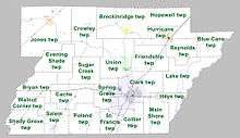
Townships in Arkansas are the divisions of a county. Each township includes unincorporated areas; some may have incorporated cities or towns within part of their boundaries. Arkansas townships have limited purposes in modern times. However, the United States Census does list Arkansas population based on townships (sometimes referred to as "county subdivisions" or "minor civil divisions"). Townships are also of value for historical purposes in terms of genealogical research. Each town or city is within one or more townships in an Arkansas county based on census maps and publications. The townships of Greene County are listed below; listed in parentheses are the cities, towns, and/or census-designated places that are fully or partially inside the township. [13][14]
- Blue Cane
- Breckenridge (Lafe)
- Bryan
- Cache
- Clark (most of Paragould)
- Collier
- Crowley
- Evening Shade
- Friendship
- Hays
- Hopewell
- Hurricane (Marmaduke)
- Jones (Delaplaine)
- Lake
- Main Shore
- Poland
- Reynolds
- St. Francis (small part of Paragould)
- Salem
- Shady Grove
- Spring Grove (part of Paragould)
- Sugar Creek
- Union (Oak Grove Heights)
- Walnut Corner
See also
- Lake Frierson State Park
- List of lakes in Greene County, Arkansas
- National Register of Historic Places listings in Greene County, Arkansas
References
- "State & County QuickFacts". United States Census Bureau. Archived from the original on June 7, 2011. Retrieved May 21, 2014.
- "Find a County". National Association of Counties. Archived from the original on 2011-05-31. Retrieved 2011-06-07.
- Neville, A. W. (March 2, 1945). "Backward Glances". The Paris News. Paris, Texas. p. 4 – via Newspapers.com.
On the survey from Bird's Point, Mo., to Jonesboro, Ark., I had a Negro cook. As Negroes were not allowed to live in Clay, Greene and Craighead Counties, Ark., my cook was a curiosity to the children. The women used to bring the children to camp to see him.
- "2010 Census Gazetteer Files". United States Census Bureau. August 22, 2012. Retrieved August 26, 2015.
- "Population and Housing Unit Estimates". Retrieved September 28, 2019.
- "U.S. Decennial Census". United States Census Bureau. Retrieved August 26, 2015.
- "Historical Census Browser". University of Virginia Library. Retrieved August 26, 2015.
- Forstall, Richard L., ed. (March 27, 1995). "Population of Counties by Decennial Census: 1900 to 1990". United States Census Bureau. Retrieved August 26, 2015.
- "Census 2000 PHC-T-4. Ranking Tables for Counties: 1990 and 2000" (PDF). United States Census Bureau. April 2, 2001. Retrieved August 26, 2015.
- Based on 2000 census data
- "U.S. Census website". United States Census Bureau. Retrieved 2011-05-14.
- "Dave Leip's Atlas of U.S. Presidential Elections". Retrieved November 18, 2016.
- 2011 Boundary and Annexation Survey (BAS): Greene County, AR (PDF) (Map). U. S. Census Bureau. Archived from the original (PDF) on 2012-10-19. Retrieved 2011-08-09.
- "Arkansas: 2010 Census Block Maps - County Subdivision". United States Census Bureau. Retrieved May 28, 2014.
External links
| Wikimedia Commons has media related to Greene County, Arkansas. |
Places adjacent to Greene County, Arkansas | ||||||||||
|---|---|---|---|---|---|---|---|---|---|---|
| ||||||||||
Municipalities and communities of Greene County, Arkansas, United States | ||
|---|---|---|
| Cities | Map of Arkansas highlighting Greene County | |
| Towns | ||
| Unincorporated communities | ||

| Authority control |
|
|---|