Cleburne County, Arkansas
Cleburne County is a county located in the U.S. state of Arkansas. As of the 2010 census, the population was 25,970.[1] The county seat and most populous city is Heber Springs.[2] The county was formed on February 20, 1883 as the last of Arkansas's 75 counties to be formed. It is named for Confederate General Patrick Cleburne.[3] Cleburne is an alcohol prohibition or dry county.
Cleburne County | |
|---|---|
 Cleburne County Courthouse in Heber Springs, Arkansas | |
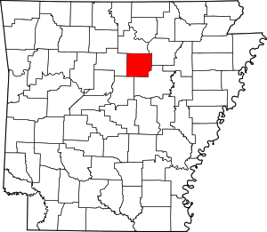 Location within the U.S. state of Arkansas | |
 Arkansas's location within the U.S. | |
| Coordinates: 35°32′06″N 92°00′46″W | |
| Country | |
| State | |
| Founded | February 20, 1883 |
| Named for | Patrick Cleburne |
| Seat | Heber Springs |
| Largest city | Heber Springs |
| Area | |
| • Total | 592 sq mi (1,530 km2) |
| • Land | 554 sq mi (1,430 km2) |
| • Water | 38 sq mi (100 km2) 6.5%% |
| Population (2010) | |
| • Total | 25,970 |
| • Estimate (2019) | 24,919 |
| • Density | 44/sq mi (17/km2) |
| Time zone | UTC−6 (Central) |
| • Summer (DST) | UTC−5 (CDT) |
| Congressional district | 1st |
| Website | www |
Geography
According to the U.S. Census Bureau, the county has a total area of 592 square miles (1,530 km2), of which 554 square miles (1,430 km2) is land and 38 square miles (98 km2) (6.5%) is water.[4] Much of the water area in the County includes Greers Ferry Lake, which extends westward into neighboring Van Buren County.
Major highways


Arkansas Highway 225
Adjacent counties
- Stone County (north)
- Independence County (northeast)
- White County (southeast)
- Faulkner County (southwest)
- Van Buren County (west)
Demographics
| Historical population | |||
|---|---|---|---|
| Census | Pop. | %± | |
| 1890 | 7,884 | — | |
| 1900 | 9,628 | 22.1% | |
| 1910 | 11,903 | 23.6% | |
| 1920 | 12,696 | 6.7% | |
| 1930 | 11,373 | −10.4% | |
| 1940 | 13,134 | 15.5% | |
| 1950 | 11,487 | −12.5% | |
| 1960 | 9,059 | −21.1% | |
| 1970 | 10,349 | 14.2% | |
| 1980 | 16,909 | 63.4% | |
| 1990 | 19,411 | 14.8% | |
| 2000 | 24,046 | 23.9% | |
| 2010 | 25,850 | 7.5% | |
| Est. 2019 | 24,919 | [5] | −3.6% |
| U.S. Decennial Census[6] 1790–1960[7] 1900–1990[8] 1990–2000[9] 2010–2016[1] | |||
As of the 2000 census,[11] there were 24,046 people, 10,190 households, and 7,408 families residing in the county. The population density was 44 people per square mile (17/km²). There were 13,732 housing units at an average density of 25 per square mile (10/km²). The racial makeup of the county was 98.20% White, 0.12% Black or African American, 0.47% Native American, 0.15% Asian, 0.02% Pacific Islander, 0.15% from other races, and 0.89% from two or more races. 1.17% of the population were Hispanic or Latino of any race.
There were 10,190 households out of which 26.30% had children under the age of 18 living with them, 61.70% were married couples living together, 7.90% had a female householder with no husband present, and 27.30% were non-families. 24.40% of all households were made up of individuals and 12.30% had someone living alone who was 65 years of age or older. The average household size was 2.33 and the average family size was 2.74.
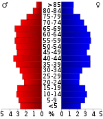
In the county, the population was spread out with 21.30% under the age of 18, 6.60% from 18 to 24, 24.10% from 25 to 44, 26.90% from 45 to 64, and 21.10% who were 65 years of age or older. The median age was 44 years. For every 100 females there were 93.90 males. For every 100 females age 18 and over, there were 92.50 males.
The median income for a household in the county was $31,531, and the median income for a family was $37,273. Males had a median income of $28,844 versus $19,672 for females. The per capita income for the county was $17,250. About 9.00% of families and 13.10% of the population were below the poverty line, including 17.10% of those under age 18 and 11.90% of those age 65 or over.
Government
| Year | GOP | Dem | Others |
|---|---|---|---|
| 2016 | 78.26% 9,458 | 17.39% 2,101 | 4.36% 526 |
| 2012 | 74.64% 8,693 | 22.50% 2,620 | 2.87% 334 |
| 2008 | 70.22% 7,962 | 26.03% 2,951 | 3.75% 425 |
| 2004 | 60.43% 7,107 | 38.41% 4,517 | 1.16% 137 |
| 2000 | 56.14% 5,730 | 40.36% 4,120 | 3.49% 357 |
| 1996 | 40.23% 3,807 | 47.28% 4,475 | 12.49% 1,182 |
| 1992 | 35.87% 3,580 | 51.00% 5,090 | 13.13% 1,310 |
| 1988 | 58.85% 4,932 | 40.62% 3,404 | 0.54% 45 |
| 1984 | 64.04% 5,769 | 35.21% 3,172 | 0.74% 67 |
| 1980 | 48.38% 4,042 | 48.13% 4,021 | 3.49% 292 |
| 1976 | 25.77% 1,992 | 74.07% 5,726 | 0.17% 13 |
| 1972 | 67.15% 2,870 | 32.76% 1,400 | 0.09% 4 |
| 1968 | 31.27% 1,301 | 28.89% 1,202 | 39.83% 1,657 |
| 1964 | 31.51% 1,221 | 68.26% 2,645 | 0.23% 9 |
| 1960 | 44.96% 1,026 | 50.13% 1,144 | 4.91% 112 |
| 1956 | 46.24% 947 | 53.42% 1,094 | 0.34% 7 |
| 1952 | 46.58% 918 | 53.02% 1,045 | 0.41% 8 |
| 1948 | 21.56% 312 | 73.32% 1,061 | 5.11% 74 |
| 1944 | 40.50% 582 | 58.39% 839 | 1.11% 16 |
| 1940 | 30.71% 374 | 68.47% 834 | 0.82% 10 |
| 1936 | 26.44% 336 | 72.93% 927 | 0.63% 8 |
| 1932 | 10.29% 204 | 88.29% 1,750 | 1.41% 28 |
| 1928 | 39.81% 574 | 59.36% 856 | 0.83% 12 |
| 1924 | 26.44% 238 | 63.22% 569 | 10.33% 93 |
| 1920 | 38.06% 459 | 56.22% 678 | 5.72% 69 |
| 1916 | 23.86% 271 | 76.14% 865 | 0.00% 0 |
| 1912 | 15.33% 138 | 57.44% 517 | 27.22% 245 |
| 1908 | 31.65% 294 | 54.47% 506 | 13.89% 129 |
| 1904 | 31.15% 214 | 57.35% 394 | 11.50% 79 |
| 1900 | 25.03% 205 | 63.49% 520 | 11.48% 94 |
| 1896 | 9.26% 108 | 89.79% 1,047 | 0.94% 11 |
Over The past few election cycles Cleburne county has trended heavily towards the GOP. The last democrat (as of 2016) to carry this county was Bill Clinton in 1996.
Communities
Cities
- Fairfield Bay (mostly in Van Buren County)
- Greers Ferry
- Heber Springs (county seat)
- Quitman (partly in Faulkner County)
Census-designated place
Other unincorporated communities
Townships
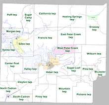
Townships in Arkansas are the divisions of a county. Each township includes unincorporated areas; some may have incorporated cities or towns within part of their boundaries. Arkansas townships have limited purposes in modern times. However, the United States Census does list Arkansas population based on townships (sometimes referred to as "county subdivisions" or "minor civil divisions"). Townships are also of value for historical purposes in terms of genealogical research. Each town or city is within one or more townships in an Arkansas county based on census maps and publications. The townships of Cleburne County are listed below; listed in parentheses are the cities, towns, and/or census-designated places that are fully or partially inside the township. [13][14]
- California
- Center Post
- Clayton
- East Peter Creek
- Francis
- Giles (Greers Ferry)
- Grassey (Concord)
- Healing Springs
- Heber (most of Heber Springs)
- McJester
- Morgan (part of Fairfield Bay)
- Mountain
- North Cadron (part of Quitman)
- Pickens
- Pine
- Piney
- Poff
- Saline (Higden)
- South Cadron (part of Quitman)
- Sugar Camp
- Sugar Loaf
- Valley (part of Heber Springs)
- West Peter Creek (Tumbling Shoals)
- Wilburn
See also
- List of lakes in Cleburne County, Arkansas
- National Register of Historic Places listings in Cleburne County, Arkansas
References
- "State & County QuickFacts". United States Census Bureau. Archived from the original on July 8, 2011. Retrieved May 20, 2014.
- "Find a County". National Association of Counties. Archived from the original on 2011-05-31. Retrieved 2011-06-07.
- Gannett, Henry (1905). The Origin of Certain Place Names in the United States. Govt. Print. Off. pp. 84.
- "2010 Census Gazetteer Files". United States Census Bureau. August 22, 2012. Retrieved August 25, 2015.
- "Population and Housing Unit Estimates". Retrieved September 28, 2019.
- "U.S. Decennial Census". United States Census Bureau. Retrieved August 25, 2015.
- "Historical Census Browser". University of Virginia Library. Retrieved August 25, 2015.
- Forstall, Richard L., ed. (March 27, 1995). "Population of Counties by Decennial Census: 1900 to 1990". United States Census Bureau. Retrieved August 25, 2015.
- "Census 2000 PHC-T-4. Ranking Tables for Counties: 1990 and 2000" (PDF). United States Census Bureau. April 2, 2001. Retrieved August 25, 2015.
- Based on 2000 census data
- "U.S. Census website". United States Census Bureau. Retrieved 2011-05-14.
- "Dave Leip's Atlas of U.S. Presidential Elections". Retrieved November 18, 2016.
- 2011 Boundary and Annexation Survey (BAS): Cleburne County, AR (PDF) (Map). U. S. Census Bureau. Archived from the original (PDF) on 2012-10-19. Retrieved 2011-08-07.
- "Arkansas: 2010 Census Block Maps - County Subdivision". United States Census Bureau. Retrieved May 27, 2014.
Places adjacent to Cleburne County, Arkansas | ||||||||||
|---|---|---|---|---|---|---|---|---|---|---|
| ||||||||||
Municipalities and communities of Cleburne County, Arkansas, United States | ||
|---|---|---|
| Cities | Map of Arkansas highlighting Cleburne County | |
| Towns | ||
| CDP | ||
| Unincorporated communities | ||
| Footnotes | ‡This populated place also has portions in an adjacent county or counties | |

| Authority control |
|
|---|