Arkansas Highway 367
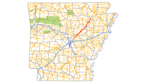
Arkansas Highway 367 (AR 367 or Hwy. 367) is a designation for two north–south state highways in Arkansas. A southern route of 15.03 miles (24.19 km) travels north from U.S. Route 167 (US 167) in East End north to US 70 in Little Rock.[2][3] A northern route of 81.52 miles (131.19 km) begins in Cabot at US 67/AR 5/AR 321 and travels northeast to US 412 in Walnut Ridge.[4][5]
| ||||
|---|---|---|---|---|
 | ||||
| Route information | ||||
| Maintained by ArDOT | ||||
| Section 1 | ||||
| Length | 15.03 mi[1] (24.19 km) | |||
| South end | ||||
| North end | ||||
| Section 2 | ||||
| Length | 81.52 mi[1] (131.19 km) | |||
| South end | ||||
| North end | ||||
| Highway system | ||||
| ||||

Route description
East End to Little Rock
The southern segment begins in Little Rock, Arkansas at an intersection with US 70 (Roosevelt Road) as part of Arch Street. Its southern terminus is at an intersection with US 167 south of East End, Arkansas. Traveling generally north to south, it is a former alignment of US 167. It is commonly known as "Arch Street" or "Arch Street Pike" after the Little Rock street.
Cabot to Walnut Ridge
The northern segment begins at an intersection with US 412 and AR 34 at Walnut Ridge; its southern terminus is in Cabot, Arkansas at an intersection with US 67, AR 5, and AR 321. Traveling mostly northeast to southwest, it is a former alignment of US 67.
Beebe spur
| |
|---|---|
| Location | Beebe, Arkansas |
| Length | 0.49 mi[1] (0.79 km) |
Highway 367 Spur (AR 367S, Hwy. 367S) is a spur route of 0.49 miles (0.79 km) in Beebe, Arkansas.[1]
The northern terminus is at an intersection with US 67 / US 167/ US 64 (Future I-57) north of Beebe. Arkansas. Its southern terminus is in Beebe at an intersection with AR 367. It continues south as N. Pecan St.
See also
References
- Planning and Research Division (2010). "Arkansas Road Log Database". Arkansas State Highway and Transportation Department. Archived from the original (Database) on 23 June 2011. Retrieved June 9, 2011.
- General Highway Map, Saline County, Arkansas (PDF) (Map). 1:62500. Cartography by Planning and Research Division. Arkansas State Highway and Transportation Department. 2010. Retrieved December 17, 2011.
- General Highway Map, Pulaski County, Arkansas (PDF) (Map). 1:62500. Cartography by Planning and Research Division. Arkansas State Highway and Transportation Department. 2007. Retrieved December 17, 2011.
- General Highway Map, Lonoke County, Arkansas (PDF) (Map). 1:62500. Cartography by Planning and Research Division. Arkansas State Highway and Transportation Department. 2010. Retrieved December 17, 2011.
- General Highway Map, Jackson County, Arkansas (PDF) (Map). 1:62500. Cartography by Planning and Research Division. Arkansas State Highway and Transportation Department. 2010. Retrieved December 17, 2011.