Scott, Arkansas
Scott is an unincorporated community and census-designated place (CDP) in Lonoke and Pulaski counties in the central part of the U.S. state of Arkansas. The population was 72 at the 2010 census.[2] It is part of the Little Rock–North Little Rock–Conway Metropolitan Statistical Area.
Scott, Arkansas | |
|---|---|
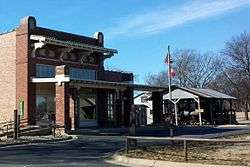 Plantation Agriculture Museum operated by the Arkansas Department of Parks and Tourism | |
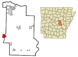 Location in Lonoke County and the state of Arkansas | |
 Scott, Arkansas Location in the United States | |
| Coordinates: 34°41′39″N 92°5′41″W | |
| Country | United States |
| State | Arkansas |
| Counties | Pulaski, Lonoke |
| Area | |
| • Total | 3.32 sq mi (8.59 km2) |
| • Land | 3.17 sq mi (8.21 km2) |
| • Water | 0.15 sq mi (0.38 km2) |
| Elevation | 249 ft (76 m) |
| Population (2010) | |
| • Total | 72 |
| • Density | 22.7/sq mi (8.77/km2) |
| Time zone | UTC-6 (Central (CST)) |
| • Summer (DST) | UTC-5 (CDT) |
| ZIP code | 72142 |
| Area code(s) | 501 |
| FIPS code | 05-62900 |
| GNIS feature ID | 0054634 |
Geography
Scott is located in western Lonoke County and eastern Pulaski County at 34°41′39″N 92°05′41″W.[3] It is bordered to the west by the city of North Little Rock. U.S. Route 165 passes through the community, leading northwest approximately 4 miles (6.4 km) to Interstate 440 and southeast 8 miles (13 km) to Keo. Downtown Little Rock is 12 miles (19 km) west of Scott. Arkansas Highway 161 runs concurrently with the Lonoke-Pulaski county line in the community, progressing northward to U.S. Route 70 and southeast to England, by way of farming areas in southeast Pulaski County.
According to the United States Census Bureau, the Scott CDP has a total area of 3.3 square miles (8.5 km2), of which 3.2 square miles (8.3 km2) are land and 0.15 square miles (0.39 km2) (4.52%) are water.[1] The CDP's portion in Pulaski County is bisected by Horseshoe Lake, an oxbow lake that was once a channel of the Arkansas River.
Demographics
| Historical population | |||
|---|---|---|---|
| Census | Pop. | %± | |
| U.S. Decennial Census[4] | |||
As of the census[5] of 2000, there were 94 people, 40 households, and 29 families residing in the CDP. The population density was 15.7 people per square mile (6.1/km2). There were 46 housing units at an average density of 7.7/sq mi (3.0/km2). The racial makeup of the CDP was 64.89% White, 34.04% Black or African American, and 1.06% from two or more races.
There were 40 households, out of which 30.0% had children under the age of 18 living with them, 50.0% were married couples living together, 20.0% had a female householder with no husband present, and 27.5% were non-families. 20.0% of all households were made up of individuals, and none had someone living alone who was 65 years of age or older. The average household size was 2.35 and the average family size was 2.76.
In the CDP, the population was spread out, with 25.5% under the age of 18, 6.4% from 18 to 24, 26.6% from 25 to 44, 37.2% from 45 to 64, and 4.3% who were 65 years of age or older. The median age was 43 years. For every 100 females, there were 84.3 males. For every 100 females age 18 and over, there were 89.2 males.
The median income for a household in the CDP was $24,821, and the median income for a family was $32,321. Males had a median income of $16,786 versus $19,464 for females. The per capita income for the CDP was $10,912. None of the population and none of the families were below the poverty line.
Education
Scott is served by the Pulaski County Special School District; however, it does not maintain a school in the area. Previously, the district operated an elementary and a high school in Scott. Since its PCSSD closure, the former Scott Elementary School has reopened as a charter school for students in kindergarten through sixth grade.[6]
Points of interest
The Arkansas Department of Parks & Tourism operates two facilities in the Scott area, one on the Pulaski County side and the other on the Lonoke County side, each with a focus on local history:
- Plantation Agriculture Museum, located on the Pulaski County side, displays artifacts from the area's history in large farming operations, particularly cotton cultivation. The museum is housed in a 1920s-era cotton gin, and chronicles the period from Arkansas's statehood in 1836 to the end of World War II.
- Toltec Mounds Archeological State Park, located on the Lonoke County side, focuses on the site of a Native American civilization that lived just east of present-day Scott nearly 1,000 years ago. Mounds at the park comprise one of the most significant remnants of Native American life in the state, and are listed on the National Register of Historic Places. The Arkansas Archeological Survey, part of the University of Arkansas system, maintains its Toltec Research Station and laboratory in the park's visitor center.
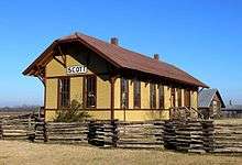
Additionally, the history of Scott can be found at three other sites around the community. Near the county line is the Scott Plantation Settlement, a grouping of relocated buildings, which includes the wooden Cotton Belt Railroad Depot that served Scott, representing an example of a plantation-era community (much in the same fashion as Little Rock's Historic Arkansas Museum). Marlsgate, the area's best known example of a plantation family home, was constructed by the Dortch family early in the 20th century and is a popular site for weddings and receptions today. The Chapel of All Souls Church Interdenominational is an architectural gem from the turn of the twentieth century, is listed on the National Register of Historic Places, and has been in continuous use by the church since 1906.
Prior to a fire that destroyed the structure in 2017, Cotham's Mercantile Store, a widely known community restaurant favored by former President Bill Clinton, was housed in a former general store building constructed in 1912, and displayed multiple antique farm implements.
Notable people
- Catherine Tharp Altvater lived in Scott for the last ten years of her life.
References
- "2016 U.S. Gazetteer Files". United States Census Bureau. Retrieved Jul 18, 2017.
- "U.S. Census website". U.S. Census Bureau. Retrieved 6 May 2011.
- "US Gazetteer files: 2010, 2000, and 1990". United States Census Bureau. 2011-02-12. Retrieved 2011-04-23.
- "Census of Population and Housing". Census.gov. Retrieved June 4, 2016.
- "U.S. Census website". United States Census Bureau. Retrieved 2008-01-31.
- "SCS". sites.google.com. Retrieved 2019-10-01.
External links
- Plantation Agriculture Museum
- Scenic highlights in Scott as provided by the Arkansas Department of Parks & Tourism
Municipalities and communities of Lonoke County, Arkansas, United States | ||
|---|---|---|
| Cities |  Map of Arkansas highlighting Lonoke County | |
| Towns | ||
| CDP | ||
| Townships |
| |
| Unincorporated communities | ||
| Footnotes | ‡This populated place also has portions in an adjacent county or counties | |
Municipalities and communities of Pulaski County, Arkansas, United States | ||
|---|---|---|
| Cities | 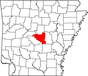 Map of Arkansas highlighting Pulaski County | |
| CDPs | ||
| Unincorporated communities | ||
| Footnotes | ‡This populated place also has portions in an adjacent county or counties | |