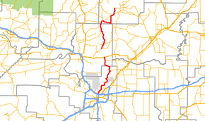
Arkansas Highway 107
Arkansas Highway 107 is the name of multiple state highways in Arkansas.[1][2][3]
| ||||
|---|---|---|---|---|
 | ||||
| Route information | ||||
| Maintained by ArDOT | ||||
| Section 1 | ||||
| Length | 33.2 mi (53.4 km) | |||
| South end | ||||
| North end | ||||
| Section 2 | ||||
| Length | 22.8 mi (36.7 km) | |||
| South end | ||||
| North end | ||||
| Highway system | ||||
| ||||

Section 1
Arkansas Highway 107 is a state highway of 33.2 miles (53.4 km) that runs in Faulkner and Cleburne counties.[1][2]
Route description
AR 107 begins at AR 36 near Holland. The route runs north to meet AR 25 and AR 225 before entering Quitman and Cleburne County. In Quitman, AR 25 also meets AR 124, which it follows east out of town. After breaking north, AR 107 reunites with AR 25 north to an area just south of Heber Springs. AR 107 ends at AR 110 in Heber Springs. AR 107 has 16.2 miles (26.1 km) in Faulkner County and 17.0 miles (27.4 km) in Cleburne County.[1][2]
Major intersections
| County | Location | mi[1][2] | km | Destinations | Notes |
|---|---|---|---|---|---|
| Cleburne | Holland | 0.0 | 0.0 | Southern terminus | |
| Enola | 2.9 | 4.7 | |||
| Enders | 11.9 | 19.2 | AR 225 concurrency begins | ||
| Quitman | 16.1 | 25.9 | AR 25 concurrency begins | ||
| Cleburne | 17.5 | 28.2 | AR 124 concurrency begins | ||
| 17.9 | 28.8 | AR 225 concurrency ends, AR 356 eastern terminus | |||
| 18.1 | 29.1 | AR 25 concurrency ends | |||
| 23.0 | 37.0 | AR 124 concurrency ends | |||
| Pearson | 27.3 | 43.9 | AR 25 concurrency begins | ||
| 28.3 | 45.5 | AR 16 concurrency begins | |||
| Heber Springs | 29.6 | 47.6 | AR 16/AR 25 concurrency ends | ||
| 33.2 | 53.4 | Northern terminus | |||
1.000 mi = 1.609 km; 1.000 km = 0.621 mi
| |||||
Section 2
Arkansas Highway 107 is a state highway of 18.7 miles (30.1 km) that runs in Pulaski and Faulkner counties.[2][3]
Route description
AR 107 begins at Interstate 40 in North Little Rock and runs through some suburbs until entering Faulkner County. The route runs north to terminate at US 64 in Vilonia. AR 107 has 16.4 miles (26.4 km) in Pulaski County and 6.4 miles (10.3 km) in Faulkner County.[2][3]
Major intersections
| County | Location | mi[2][3] | km | Destinations | Notes |
|---|---|---|---|---|---|
| Pulaski | North Little Rock | 0.0 | 0.0 | Southern terminus | |
| Sherwood | 4.6 | 7.4 | AR 176 western terminus | ||
| Zion Hill | 18.6 | 29.9 | AR 89 western terminus | ||
| Faulkner | Vilonia | 20.7 | 33.3 | AR 319 western terminus | |
| 22.8 | 36.7 | Northern terminus | |||
1.000 mi = 1.609 km; 1.000 km = 0.621 mi
| |||||
See also
References
- "Cleburne County, Arkansas." Arkansas State Highway and Transportation Department. AHTD Cleburne County map Retrieved on August 28, 2010.
- "Faulkner County, Arkansas." Arkansas State Highway and Transportation Department. AHTD Faulkner County map Retrieved on August 28, 2010.
- "Pulaski County, Arkansas." Arkansas State Highway and Transportation Department. AHTD Pulaski County map Retrieved on August 28, 2010.
External links
![]()