Arkansas Highway 310
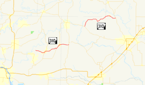
Highway 310 (AR 310, Ark. 310, and Hwy. 310) is a designation for two state highways in Central Arkansas. One route of 13.40 miles (21.57 km) begins at Highway 36 and runs east to Highway 16.[2] A second route of 11.01 miles (17.72 km) begins at Highway 5 and runs west to Faulkner County Route 310 (CR 310) Clinton Mountain Road west of Enola.[lower-alpha 1][2][4] All routes are maintained by the Arkansas Department of Transportation (ArDOT).
| ||||
|---|---|---|---|---|
 | ||||
| Route information | ||||
| Maintained by ArDOT | ||||
| Length | 13.40 mi (21.57 km) | |||
| Section 1 | ||||
| West end | ||||
| East end | ||||
| Section 2 | ||||
| Length | 11.01 mi[1] (17.72 km) | |||
| East end | ||||
| West end | ||||
| Location | ||||
| Counties | White, Cleburne Faulkner | |||
| Highway system | ||||
| ||||

History

Highway 310 was created between Highway 36 and Sidon by the Arkansas State Highway Commission (ASHC) on November 23, 1966.[5] The section between Highway 5 and the Faulkner County line was added to the state highway system by the ASHC on March 3, 1988.[6]
In 1992, following the consolidation of the Enola and Mount Vernon school districts, the ASHC authorized AHTD to study if adding a road between the two communities would be feasible.[7] The study resulted in adding the former White CR 67 between Enola and Mount Vernon to the state highway system as Highway 310. The resolution also authorized the decommissioning of a short segment of Highway 310 at Guy and Highway 287 near Greenbrier.[8]
Major intersections
| County | Location | mi | km | Destinations | Notes | |||
|---|---|---|---|---|---|---|---|---|
| White | | 0.00 | 0.00 | Western terminus | ||||
| Cleburne |
No major junctions | |||||||
| White | | 13.40 | 21.57 | Eastern terminus | ||||
| Gap in route | ||||||||
| | 0.00 | 0.00 | Eastern terminus | |||||
| Faulkner | Mount Vernon | 3.16– 0.00 | 5.09– 0.00 | |||||
| Enola | 3.9 | 6.3 | ||||||
| | 7.85 | 12.63 | Western terminus | |||||
1.000 mi = 1.609 km; 1.000 km = 0.621 mi
| ||||||||
Former route
| |
|---|---|
| Location | Guy - Greenbrier |
| Existed | ?–2004[8] |
See also
Notes
- Although Arkansas highways normally run from west to east, Highway 310 begins at Highway 5 and terminates at Clinton Mountain Road.[3]
References
- Planning and Research Division (March 28, 2012). "Arkansas Road Log Database". Little Rock: Arkansas State Highway and Transportation Department. Archived from the original (MBD) on June 23, 2011. Retrieved April 13, 2012.
- Planning and Research Division (July 14, 2015). General Highway Map, White County, Arkansas (PDF) (Map). Little Rock: Arkansas State Highway and Transportation Department. Retrieved May 22, 2016.
- Arkansas State Highway and Transportation Department. Route and Section Map (PDF) (Map) (Faulkner County ed.). Arkansas State Highway and Transportation Department. Retrieved May 22, 2016.
- Planning and Research Division (February 17, 2015). General Highway Map, Faulkner County, Arkansas (PDF) (Map). Little Rock: Arkansas State Highway and Transportation Department. Retrieved May 22, 2016.
- Arkansas State Highway Commission (November 23, 1966). "Minute Order 66-066" (PDF). Minutes of the Meeting. Little Rock: Arkansas State Highway Commission. p. 568. Retrieved May 22, 2016.
- Arkansas State Highway Commission (March 3, 1988). "Minute Order 88-087" (PDF). Minutes of the Meeting. Little Rock: Arkansas State Highway Commission. pp. 926–927. Retrieved May 22, 2016.
- Arkansas State Highway Commission (January 22, 1992). "Minute Order 92-022" (PDF). Minutes of the Meeting. Little Rock: Arkansas State Highway Commission. p. 200. Retrieved May 22, 2016.
- Arkansas State Highway Commission (November 21, 1995). "Minute Order 95-206" (PDF). Minutes of the Meeting. Little Rock: Arkansas State Highway Commission. p. 713. Retrieved May 22, 2016.
External links
