Horseshoe Bend, Arkansas
Horseshoe Bend is a city in Fulton, Izard, and Sharp counties in the U.S. state of Arkansas. The population was 2,184 at the 2010 census.[4] It is named for the large loop or horseshoe bend in the nearby Strawberry River.[5]
Horseshoe Bend, Arkansas | |
|---|---|
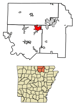 Location of Horseshoe Bend in Fulton County and Izard County and Sharp County, Arkansas. | |
| Coordinates: 36°13′28″N 91°44′40″W | |
| Country | United States |
| State | Arkansas |
| Counties | Izard, Fulton, Sharp |
| Area | |
| • Total | 14.59 sq mi (37.78 km2) |
| • Land | 13.29 sq mi (34.42 km2) |
| • Water | 1.30 sq mi (3.36 km2) |
| Elevation | 873 ft (266 m) |
| Population (2010) | |
| • Total | 2,184 |
| • Estimate (2019)[3] | 2,109 |
| • Density | 158.69/sq mi (61.27/km2) |
| Time zone | UTC-6 (Central (CST)) |
| • Summer (DST) | UTC-5 (CDT) |
| ZIP code | 72512 |
| Area code(s) | 870 |
| FIPS code | 05-33370 |
| GNIS feature ID | 0065874[2] |
| Website | cityofhorseshoebend |
Geography
Horseshoe Bend is located in northeast Izard County and extends into northeast Sharp and southern Fulton counties. The city is on the east banks of the Strawberry River. The city includes Crown Lake and Diamond Lake made by impounding the waters of Bens Creek and other small tributaries.[6]
According to the United States Census Bureau, the city has a total area of 14.6 square miles (38 km2), of which 13.4 square miles (35 km2) is land, and 1.2 square miles (3.1 km2) (8.50%) is water.
Demographics
| Historical population | |||
|---|---|---|---|
| Census | Pop. | %± | |
| 1970 | 321 | — | |
| 1980 | 1,909 | 494.7% | |
| 1990 | 2,239 | 17.3% | |
| 2000 | 2,278 | 1.7% | |
| 2010 | 2,184 | −4.1% | |
| Est. 2019 | 2,109 | [3] | −3.4% |
| U.S. Decennial Census[7] | |||
As of the census[8] of 2000, there were 2,278 people, 1,142 households, and 725 families residing in the city. The population density was 170.6 people per square mile (65.9/km2). There were 1,451 housing units at an average density of 108.7/sq mi (42.0/km2). The racial makeup of the city was 97.28% White, 0.22% Black or African American, 0.88% Native American, 0.13% Asian, 0.04% Pacific Islander, 0.40% from other races, and 1.05% from two or more races. 1.23% of the population were Hispanic or Latino of any race.
There were 1,142 households, out of which 11.6% had children under the age of 18 living with them, 56.7% were married couples living together, 4.6% had a female householder with no husband present, and 36.5% were non-families. 33.8% of all households were made up of individuals, and 24.3% had someone living alone who was 65 years of age or older. The average household size was 1.95 and the average family size was 2.42.
In the city, the population was spread out, with 12.8% under the age of 18, 3.4% from 18 to 24, 13.5% from 25 to 44, 24.6% from 45 to 64, and 45.7% who were 65 years of age or older. The median age was 63 years. For every 100 females, there were 86.9 males. For every 100 females age 18 and over, there were 84.2 males.
The median income for a household in the city was $26,714, and the median income for a family was $34,129. Males had a median income of $24,286 versus $17,688 for females. The per capita income for the city was $18,987. About 6.9% of families and 10.8% of the population were below the poverty line, including 26.7% of those under age 18 and 2.6% of those age 65 or over.
Government
City government
City government is a mayor-council government. It consists of a mayor and eight (8) council members representing four (4) wards.[9][10]
City Court
The City Court has jurisdiction over misdemeanor, criminal, traffic and municipal ordinance violations and cases that occur within the city.[11]
Municipal services
Police
The Horseshoe Bend Police Department was disbanded in 2013, its duties assumed by the Izard County Sherriffs office.
Fire
The Horseshoe Bend Volunteer Fire Department consists of 12 volunteers and covers 45 square miles of residential and commercial properties as well as wetlands. The Department is responsible for fire suppression, extrication assistance, HAZMAT, and rescue. Equipment includes one (1) engine / pumper, one (1) tanker, one (1) brush / quick-attack vehicle, and one (1) emergency rescue vehicle. The department currently has an Insurance Services Office, Inc. (ISO) Public Protection Classification (PPC™) Service rating of 6.[12]
Water / Sewer
Animal Control
Animal Control maintains a facility where lost dogs and cats are kept for adoption. It is staffed by employees and volunteers. A five-day waiting period is observed with the hopes that the pet will be reunited with its owner. Animals must be spayed / neutered and vaccinated prior to adoption. Assistance with these fees is available through the Friends of Horseshoe Bend Animals.[13]
Library
The Horseshoe Bend Library was created in 1974, evolving from bookmobile service from the White Country Regional Library in Batesville, Arkansas that began in 1970. The library was originally housed in the Municipal Building. In 2006, the Library relocated to its new facility on Club Rd. The Library serves the city and surrounding area with services such as audio / visual equipment, computer and Internet access, a media / meeting room, and traditional reading materials. The library is supported by Friends of the Library. Library grounds are maintained by Izard Country Master Gardeners.[14]
Transportation
Major highways
Airport
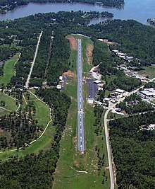
The Horseshoe Bend Airport, FAA identifier is 6M2, is owned and operated by the city. The runway is 4,524 ft. x 60 ft. and is paved.[15] It is located at 36°13′3″N 91°45′3″W (36.2213694, -91.7554833) at an elevation of 782 ft. / 238 m. Its variation is 03E.
See also
- List of cities in Arkansas
References
- "2019 U.S. Gazetteer Files". United States Census Bureau. Retrieved June 30, 2020.
- U.S. Geological Survey Geographic Names Information System: Horseshoe Bend, Arkansas
- "Population and Housing Unit Estimates". United States Census Bureau. May 24, 2020. Retrieved May 27, 2020.
- "Profile of General Population and Housing Characteristics: 2010 Demographic Profile Data (DP-1): Horseshoe Bend city, Arkansas". United States Census Bureau. Retrieved August 10, 2012.
- "About Us". Horseshoe Bend Chamber of Commerce. Retrieved 5 August 2013.
- Myron, AR and Franklin, AR, 7.5 Minute Topographic Quadrangles, US Topo, USGS, 2011
- "Census of Population and Housing". Census.gov. Retrieved June 4, 2015.
- "U.S. Census website". United States Census Bureau. Retrieved 2008-01-31.
- "Horseshoe Bend Community Services". City of Horseshoe Bend. Retrieved 5 August 2013.
- "Page 4". Horseshoe Bend Area Chamber of Commerce. Retrieved 5 August 2013.
- "Horseshoe Bend City Court". City of Horseshoe Bend. Retrieved 5 August 2013.
- "Horseshoe Bend Fire Department". City of Horseshoe Bend. Retrieved 5 August 2013.
- "Horseshoe Bend Animal Control". City of Horseshoe Bend. Retrieved 5 August 2013.
- "Horseshoe Bend Library". City of Horseshoe Bend. Retrieved 5 August 2013.
- "Horseshoe Bend Airport". City of Horseshoe Bend. Retrieved 5 August 2013.
External links
| Wikimedia Commons has media related to Horseshoe Bend, Arkansas. |
Municipalities and communities of Fulton County, Arkansas, United States | ||
|---|---|---|
| Cities |  Map of Arkansas highlighting Fulton County | |
| Town | ||
| Unincorporated communities | ||
| Footnotes | ‡This populated place also has portions in an adjacent county or counties | |
Municipalities and communities of Izard County, Arkansas, United States | ||
|---|---|---|
| Cities |  Map of Arkansas highlighting Izard County | |
| Towns | ||
| Unincorporated communities | ||
| Footnotes | ‡This populated place also has portions in an adjacent county or counties | |
Municipalities and communities of Sharp County, Arkansas, United States | ||
|---|---|---|
| Cities | 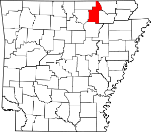 Map of Arkansas highlighting Sharp County | |
| Towns | ||
| Unincorporated communities |
| |
| Footnotes | ‡This populated place also has portions in an adjacent county or counties | |