National Register of Historic Places listings in Fulton County, Arkansas
This is a list of the National Register of Historic Places listings in Fulton County, Arkansas.
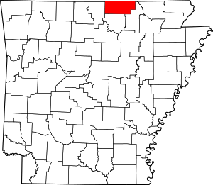
Location of Fulton County in Arkansas
This is intended to be a complete list of the properties on the National Register of Historic Places in Fulton County, Arkansas, United States. The locations of National Register properties for which the latitude and longitude coordinates are included below, may be seen in a map.[1]
There are 10 properties listed on the National Register in the county.
- This National Park Service list is complete through NPS recent listings posted August 14, 2020.[2]
Current listings
| [3] | Name on the Register[4] | Image | Date listed[5] | Location | City or town | Description |
|---|---|---|---|---|---|---|
| 1 | AR 289 Bridge Over English Creek | 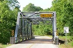 AR 289 Bridge Over English Creek |
January 22, 2009 (#08001338) |
Highway 289 over English Creek 36°26′48″N 91°34′01″W |
Mammoth Spring | |
| 2 | Camp Methodist Church | 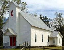 Camp Methodist Church |
May 9, 1997 (#97000402) |
Highway 9, approximately 6 miles east of Salem 36°24′44″N 91°44′16″W |
Camp | |
| 3 | County Line School and Lodge | 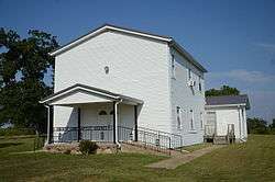 County Line School and Lodge |
March 27, 1975 (#75000386) |
Northwest of Gepp on the eastern side of the Baxter-Fulton county line, 2 miles south of the state line 36°29′13″N 92°09′00″W |
Gepp | |
| 4 | Green Valley Homestead | January 26, 2018 (#100001994) |
2605 Sturkie Rd. 36°24′20″N 91°50′37″W |
Salem vicinity | ||
| 5 | Kansas City, Fort Scott and Memphis Railroad Depot | 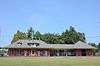 Kansas City, Fort Scott and Memphis Railroad Depot |
June 11, 1992 (#92000617) |
Southeast of the BNSF railroad tracks on an access road for Mammoth Spring State Park 36°29′45″N 91°31′54″W |
Mammoth Spring | |
| 6 | Mammoth Spring Dam and Lake | 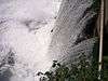 Mammoth Spring Dam and Lake |
July 15, 2009 (#09000512) |
17 U.S. Route 63, N. 36°29′43″N 91°32′12″W |
Mammoth Spring | |
| 7 | T.H. Morris House | 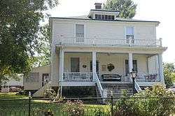 T.H. Morris House |
September 13, 1990 (#90001462) |
Junction of 6th and Bethel Sts. 36°29′41″N 91°32′37″W |
Mammoth Spring | |
| 8 | Saddle Store | 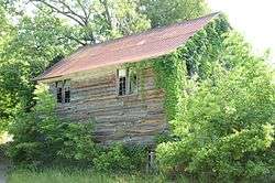 Saddle Store |
November 15, 2000 (#00001366) |
Highway 289 36°21′19″N 91°38′14″W |
Saddle | |
| 9 | Saint Andrew's Episcopal Church | 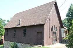 Saint Andrew's Episcopal Church |
November 26, 1986 (#86002944) |
Highway 9 36°29′42″N 91°31′58″W |
Mammoth Spring | |
| 10 | Spring River Bridge | 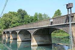 Spring River Bridge |
January 22, 2014 (#13001104) |
Riverview Dr. over Spring River 36°28′38″N 91°31′28″W |
Mammoth Spring |
See also
| Wikimedia Commons has media related to National Register of Historic Places in Fulton County, Arkansas. |
References
- The latitude and longitude information provided in this table was derived originally from the National Register Information System, which has been found to be fairly accurate for about 99% of listings. Some locations in this table may have been corrected to current GPS standards.
- "National Register of Historic Places: Weekly List Actions". National Park Service, United States Department of the Interior. Retrieved on August 14, 2020.
- Numbers represent an ordering by significant words. Various colorings, defined here, differentiate National Historic Landmarks and historic districts from other NRHP buildings, structures, sites or objects.
- "National Register Information System". National Register of Historic Places. National Park Service. March 13, 2009.
- The eight-digit number below each date is the number assigned to each location in the National Register Information System database, which can be viewed by clicking the number.
| Topics | |
|---|---|
| Lists by state |
|
| Lists by insular areas | |
| Lists by associated state | |
| Other areas | |
| Related | |
| |
Municipalities and communities of Fulton County, Arkansas, United States | ||
|---|---|---|
| Cities | Map of Arkansas highlighting Fulton County | |
| Town | ||
| Unincorporated communities | ||
| Footnotes | ‡This populated place also has portions in an adjacent county or counties | |
This article is issued from Wikipedia. The text is licensed under Creative Commons - Attribution - Sharealike. Additional terms may apply for the media files.