Walls, Mississippi
Walls is a town located in northern DeSoto County, Mississippi, United States, near the Mississippi River, part of the larger region known as "The Delta", and known for its rich, dark soil. As it is in the upper northwest corner of Mississippi, it is in the Memphis, Tennessee metropolitan area. Its ZIP code is 38680.[3] As of the 2010 census it had a population of 1,162,[4] with an estimated population of 1,463 in 2018.[5]
Walls, Mississippi | |
|---|---|
| Nickname(s): Where the Delta Meets the Bluff | |
 Location of Walls in Mississippi | |
 Walls, Mississippi Location in the United States | |
| Coordinates: 34.96°N 90.15°W | |
| Country | United States |
| State | Mississippi |
| County | DeSoto |
| Town | 2003 |
| Government | |
| • Mayor | Patty Denison |
| Area | |
| • Total | 11.96 sq mi (30.98 km2) |
| • Land | 11.84 sq mi (30.66 km2) |
| • Water | 0.13 sq mi (0.33 km2) |
| Elevation | 211 ft (64 m) |
| Population (2010) | |
| • Total | 1,162 |
| • Estimate (2019)[2] | 1,420 |
| • Density | 119.96/sq mi (46.32/km2) |
| Time zone | UTC-6 (CST) |
| • Summer (DST) | UTC-5 (CDT) |
| FIPS code | 28-77400 |
| Website | www |
History
A relatively young community, Walls was originally named "Alpika", an old Chickasaw Indian word. The name was changed to Walls in 1906.
Walls was named after Captain June Walls, who served in the Civil War. Captain Walls was an early settler and merchant of the region in the 1880s.
A Mississippian culture village site near Walls, the Walls Site, gives its name to the Walls Phase, the last prehistoric cultural expression before European contact.[6] The historic trail of Hernando de Soto leads through DeSoto County to near Walls.
Today, Walls is a community rich in agriculture. Cotton, soybeans, rice and corn are planted each spring. The railroad played a vital part in the growth of the area in the early to mid 1900s. The mechanical revolution of the 1950s and 1960s changed Walls, as well as many other Delta communities.
A significant part of the community is the Sacred Heart League, operator of the Sacred Heart School in Walls. The league raised funds through the sale of a famous statue of Jesus Christ. In the 1960s, the statue could be found on the dashboards of vehicles across America.
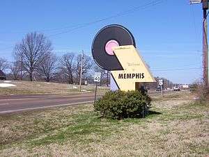
The town of Walls, which has been a community since the early 1900s, was connected to the tiny village of Memphis which was incorporated in the early 1970s and was located just south of the Walls community. In 2003/2004, the village of Memphis was annexed, thereby giving the town of Walls the official status of a municipality.
Geography
Average temperatures: January = 39.4 F July = 81.1 F
Subdivisions (in the city limits)
- Kaitlin Ridge
- Mallard Park
- Encore
Neighboring cities
- Memphis, Tennessee (north)
- Horn Lake (east)
- Tunica Resorts (southwest)
Demographics
| Historical population | |||
|---|---|---|---|
| Census | Pop. | %± | |
| 2010 | 1,162 | — | |
| Est. 2019 | 1,420 | [2] | 22.2% |
| U.S. Decennial Census[7] | |||
Education
Walls is served by the DeSoto County School District.
Secondary schools
- Lake Cormorant Middle School
- Lake Cormorant High School
Elementary schools
- Walls Elementary
- Lake Cormorant Elementary
Growth and expansion
Leatherman Development
The Leatherman family has begun to develop industrial, commercial and residential projects in town limits of Walls. The first industrial tenant, Sigma Supply Co., has moved into a new 254,000-square-foot (23,600 m2) building off US 61 and Star Landing Road in the Leatherman 325-acre (1.32 km2) industrial park. Sigma Supply is a distributor of industrial and packaging equipment and facilities supplies. The 1,900-acre (7.7 km2) Leatherman Planned Unit Development in Walls touts a new elementary school with 900 students, which opened in August 2008, joining Lake Cormorant Middle School that currently has 700 students. Lake Cormorant High School opened in 2011.[8]
Notable people
- Memphis Minnie, musician[9]
- Dan A. Sullivan, Republican member of the Arkansas House of Representatives from Jonesboro, Arkansas; former educator of Walls
References
| Wikimedia Commons has media related to Walls, Mississippi. |
- "2019 U.S. Gazetteer Files". United States Census Bureau. Retrieved July 26, 2020.
- "Population and Housing Unit Estimates". United States Census Bureau. May 24, 2020. Retrieved May 27, 2020.
- https://tools.usps.com/go/ZipLookupResultsAction!input.action?resultMode=0&companyName=&address1=&address2=&city=walls&state=MS&urbanCode=&postalCode=&zip=
- "Geographic Identifiers: 2010 Demographic Profile Data (G001): Walls town, Mississippi". U.S. Census Bureau, American Factfinder. Archived from the original on February 13, 2020. Retrieved November 2, 2015.
- "Population and Housing Unit Estimates". Retrieved February 14, 2020.
- Smith, Gerald P. (1990). "The Walls Phase and its Neighbors". In David H. Dye; Sheryl Ann Cox (eds.). Towns and Temples Along the Mississippi. University of Alabama Press. p. 136. ISBN 0-8173-0455-X.
- "Census of Population and Housing". Census.gov. Retrieved June 4, 2015.
- "Lizzie "Kid" Douglas, "Memphis Minnie" - Memphis School". National Public Radio. Retrieved August 19, 2018.
External links
Municipalities and communities of DeSoto County, Mississippi, United States | ||
|---|---|---|
| Cities | 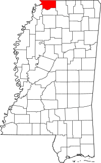 Map of Mississippi highlighting DeSoto County | |
| Town | ||
| CDPs | ||
| Other unincorporated communities | ||