Cave Springs, Arkansas
Cave Springs is a city in Benton County, Arkansas, United States. The population was 1,729 at the 2010 census,[3] up from 1,103 in 2000. It is part of the Fayetteville–Springdale–Rogers, AR-MO Metropolitan Statistical Area.
Cave Springs, Arkansas | |
|---|---|
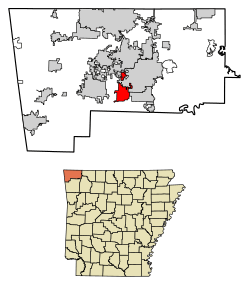 Location of Cave Springs in Benton County, Arkansas. | |
| Coordinates: 36°16′40″N 94°13′24″W | |
| Country | United States |
| State | Arkansas |
| County | Benton |
| Area | |
| • Total | 7.89 sq mi (20.44 km2) |
| • Land | 7.84 sq mi (20.30 km2) |
| • Water | 0.06 sq mi (0.15 km2) |
| Elevation | 1,155 ft (352 m) |
| Population (2010) | |
| • Total | 1,729 |
| • Estimate (2019)[2] | 5,276 |
| • Density | 673.22/sq mi (259.93/km2) |
| Time zone | UTC-6 (Central (CST)) |
| • Summer (DST) | UTC-5 (CDT) |
| ZIP code | 72718 |
| Area code(s) | 479 |
| FIPS code | 05-12340 |
| GNIS feature ID | 0076553 |
| Website | cavespringsar |
Geography
Cave Springs is located in southern central Benton County at 36°16′40″N 94°13′24″W (36.277729, -94.223226),[4] in the valley of Osage Creek. Arkansas Highway 112 (Main Street) leads north 8 miles (13 km) to Bentonville and south 16 miles (26 km) to Fayetteville. Arkansas Highway 264 (East Lowell Avenue) leads east 6 miles (10 km) to Lowell and west (as Healing Springs Road) 5 miles (8 km) to Northwest Arkansas Regional Airport.
According to the United States Census Bureau, the city has a total area of 6.9 square miles (18.0 km2), of which 6.9 square miles (17.8 km2) is land and 0.077 square miles (0.2 km2), or 0.84%, is water.[3] Lake Keith, a small water basin in the middle of Cave Springs, harbors the rare Ozark Cavefish (Amblyopsis rosae). In October 2013, Lake Keith was temporarily drained.[5]
Demographics
| Historical population | |||
|---|---|---|---|
| Census | Pop. | %± | |
| 1930 | 192 | — | |
| 1940 | 285 | 48.4% | |
| 1950 | 267 | −6.3% | |
| 1960 | 281 | 5.2% | |
| 1970 | 469 | 66.9% | |
| 1980 | 429 | −8.5% | |
| 1990 | 465 | 8.4% | |
| 2000 | 1,103 | 137.2% | |
| 2010 | 1,729 | 56.8% | |
| Est. 2019 | 5,276 | [2] | 205.1% |
| U.S. Decennial Census[6] 2015 Estimate[7] | |||
As of 2010 census the population of Cave Springs was 1,729. The racial and ethnic composition of the population was 89.9% non-Hispanic white, 0.9% black or African American, 1.3% Native American, 1.9% Asian, 0.1% Pacific Islander, 1.6% from some other race and 1.9% from two or more races. 4.5% of the population was Hispanic of Latino of any race.[8]
As of the census[9] of 2000, there were 1,103 people, 420 households, and 333 families residing in the city. The population density was 151.7 people per square mile (58.6/km2). There were 449 housing units at an average density of 61.7/sq mi (23.8/km2). The racial makeup of the city was 93.02% White, 0.09% Black or African American, 3.54% Native American, 0.27% Asian, 1.54% from other races, and 1.54% from two or more races. 2.18% of the population were Hispanic or Latino of any race.
There were 420 households, out of which 33.8% had children under the age of 18 living with them, 70.5% were married couples living together, 6.2% had a female householder with no husband present, and 20.5% were non-families. 16.9% of all households were made up of individuals, and 6.0% had someone living alone who was 65 years of age or older. The average household size was 2.63 and the average family size was 2.94.
In the city, the population was spread out, with 25.5% under the age of 18, 6.3% from 18 to 24, 31.6% from 25 to 44, 27.5% from 45 to 64, and 9.2% who were 65 years of age or older. The median age was 38 years. For every 100 females, there were 103.1 males. For every 100 females age 18 and over, there were 103.0 males.
The median income for a household in the city was $37,500, and the median income for a family was $42,813. Males had a median income of $29,167 versus $22,574 for females. The per capita income for the city was $17,946. About 7.2% of families and 9.1% of the population were below the poverty line, including 11.9% of those under age 18 and 10.5% of those age 65 or over.

Education
Public education for elementary and secondary students is provided by two school districts. The major school district is Bentonville School District, which leads to graduation from Bentonville High School. For some residents, public education is zoned to the Rogers School District.
Notable person
- Bart Hester, member of the Arkansas State Senate; resides in Cave Springs
References
- "2019 U.S. Gazetteer Files". United States Census Bureau. Retrieved June 30, 2020.
- "Population and Housing Unit Estimates". United States Census Bureau. May 24, 2020. Retrieved May 27, 2020.
- "Geographic Identifiers: 2010 Demographic Profile Data (G001): Cave Springs city, Arkansas". U.S. Census Bureau, American Factfinder. Archived from the original on February 12, 2020. Retrieved September 20, 2013.
- "US Gazetteer files: 2010, 2000, and 1990". United States Census Bureau. 2011-02-12. Retrieved 2011-04-23.
- HAAK, DELIA (October 10, 2013). "100 Years Later… Draining the Lake at Cave Springs". Archived from the original on October 24, 2016.
- "Census of Population and Housing". Census.gov. Retrieved June 4, 2015.
- "Annual Estimates of the Resident Population for Incorporated Places: April 1, 2010 to July 1, 2015". Archived from the original on 2016-10-19. Retrieved June 26, 2016.
- 2010 general profile of population and housing characteristics of Cave Springs from the Us census
- "U.S. Census website". United States Census Bureau. Retrieved 2008-01-31.
Municipalities and communities of Benton County, Arkansas, United States | ||
|---|---|---|
| Cities |  Map of Arkansas highlighting Benton County | |
| Towns | ||
| Townships | ||
| CDPs | ||
| Other communities |
| |
| Ghost towns | ||
| Footnotes | ‡This populated place also has portions in an adjacent county or counties | |