Roxburgh County
Roxburgh County was one of the original Nineteen Counties in New South Wales and is now one of the 141 Cadastral divisions of New South Wales. It includes the area to the north east of Bathurst, lying to the north and east of the Fish River to the junction of the Turon River. It includes Sofala. The Gudgegong River is the border to the north.
| Roxburgh New South Wales | |||||||||||||||
|---|---|---|---|---|---|---|---|---|---|---|---|---|---|---|---|
 Location in New South Wales | |||||||||||||||
| |||||||||||||||
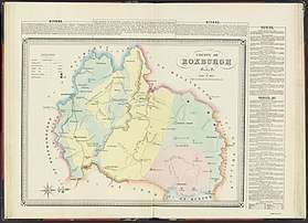
1872 map of Roxburgh County
Roxburgh County named after the Scottish county of the same name. It was named in 1829.[1]
Parishes within this county
A full list of parishes found within this county; their current LGA and mapping coordinates to the approximate centre of each location is as follows:
gollark: Yes. Democracy in action.
gollark: I complained to my MP when the government did some particularly egregious thing... complaining about end to end encryption on the news again, or something... and got a response back... from some random minister... by letter... two weeks later... which did not address anything I said and was related only in that my email and their response were both vaguely about encryption.
gollark: Er, act. Not bill.
gollark: *cough*investigatorypowersbill*cough*
gollark: It seems to mostly be spying here. The UK really likes that.
References
- "Roxburgh". Geographical Names Register (GNR) of NSW. Geographical Names Board of New South Wales.

This article is issued from Wikipedia. The text is licensed under Creative Commons - Attribution - Sharealike. Additional terms may apply for the media files.