Waradgery County
Waradgery County is one of the 141 Cadastral divisions of New South Wales. It contains the town of Hay. It includes the area between the Lachlan River and the Murrumbidgee River where they meet. The Lachlan River is the northern boundary of the county, and the Murrumbidgee for a small section is the southern boundary, but the county also includes some of the land to the south of the Murrumbidgee near Hay.
| Waradgery New South Wales | |||||||||||||||
|---|---|---|---|---|---|---|---|---|---|---|---|---|---|---|---|
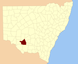 Location in New South Wales | |||||||||||||||
| |||||||||||||||
The name Waradgery is believed to be derived from a local Aboriginal word (probably in relation to the Wiradjuri people.[1]
Parishes within this county
.png)
Wajadgery County NSW as shown on John Sands' 1886 map[2]
A full list of parishes found within this county; their current LGA and mapping coordinates to the approximate centre of each location is as follows:
| Parish | LGA | Coordinates |
|---|---|---|
| Abercrombie | Hay Shire Council | 34°38′54″S 144°41′04″E |
| Beabula | Hay Shire Council | 34°29′54″S 145°10′04″E |
| Bedarbidgal | Hay Shire Council | 34°47′54″S 145°08′04″E |
| Benduck North | Hay Shire Council | 34°25′54″S 144°35′04″E |
| Benduck South | Hay Shire Council | 34°30′54″S 144°36′04″E |
| Beresford | Hay Shire Council | 34°44′54″S 144°47′04″E |
| Boyong | Hay Shire Council | 34°20′54″S 144°02′04″E |
| Brush | Hay Shire Council | 34°36′54″S 145°00′04″E |
| Budgee | Hay Shire Council | 34°21′54″S 144°19′04″E |
| Burrabogie | Hay Shire Council | 34°33′54″S 145°11′04″E |
| Chambers | Hay Shire Council | 34°47′54″S 144°00′04″E |
| Cluny | Hay Shire Council | 34°20′54″S 144°36′04″E |
| Coonoon | Hay Shire Council | 34°29′54″S 144°30′04″E |
| Cuba | Hay Shire Council | 34°47′54″S 144°55′04″E |
| Darcoola | Hay Shire Council | 34°21′54″S 144°28′04″E |
| Dowling | Hay Shire Council | 34°13′54″S 144°24′04″E |
| East Waradgery | Hay Shire Council | 34°29′54″S 144°54′04″E |
| Eli Elwah | Hay Shire Council | 34°32′54″S 144°58′04″E |
| Eurolie | Hay Shire Council | 34°44′54″S 145°09′04″E |
| Gelam | Hay Shire Council | 34°21′54″S 144°11′04″E |
| Godfrey | Hay Shire Council | 34°44′54″S 144°34′04″E |
| Grant | Hay Shire Council | 34°14′54″S 145°06′04″E |
| Gre Gre | Hay Shire Council | 34°37′54″S 144°30′04″E |
| Hay South | Hay Shire Council | 34°32′54″S 144°52′04″E |
| Hay | Hay Shire Council | 34°29′54″S 144°50′04″E |
| Hiawatha | Hay Shire Council | 34°11′54″S 144°49′04″E |
| Ilginbah | Hay Shire Council | 34°39′54″S 145°10′04″E |
| Illilawa | Hay Shire Council | 34°20′54″S 145°00′04″E |
| Ina | Hay Shire Council | 34°13′54″S 145°00′04″E |
| Jellalabad | Hay Shire Council | 34°27′54″S 144°23′04″E |
| Jumbuck | Hay Shire Council | 34°02′54″S 144°47′04″E |
| Killendoo | Hay Shire Council | 34°44′54″S 145°04′04″E |
| Lang | Hay Shire Council | 34°34′54″S 144°42′04″E |
| Lara | Hay Shire Council | 34°12′54″S 144°48′04″E |
| Leura | Hay Shire Council | 34°13′54″S 144°42′04″E |
| Lorraine | Hay Shire Council | 34°19′54″S 144°50′04″E |
| Magnolia | Hay Shire Council | 34°43′54″S 144°17′04″E |
| Maude | Hay Shire Council | 34°26′54″S 144°19′04″E |
| Melrose | Hay Shire Council | 34°44′54″S 144°40′04″E |
| Midgecleugh | Hay Shire Council | 34°47′54″S 144°40′04″E |
| Mingah | Hay Shire Council | 34°07′54″S 145°03′04″E |
| Mungadal | Hay Shire Council | 34°32′54″S 144°47′04″E |
| Narrawidgery | Hay Shire Council | 34°38′54″S 144°52′04″E |
| Nerang | Hay Shire Council | 34°34′54″S 144°25′04″E |
| Oxley | Hay Shire Council | 34°12′54″S 144°07′04″E |
| Palmer | Hay Shire Council | 34°23′54″S 144°24′04″E |
| Paradise East | Hay Shire Council | 34°47′54″S 144°49′04″E |
| Paradise | Hay Shire Council | 34°47′54″S 144°45′04″E |
| Patterson | Hay Shire Council | 34°09′54″S 144°36′04″E |
| Pembelgong | Hay Shire Council | 34°31′54″S 145°07′04″E |
| Pevensey | Hay Shire Council | 34°35′54″S 144°35′04″E |
| Pimpampa | Hay Shire Council | 34°24′54″S 144°14′04″E |
| Quandong | Hay Shire Council | 34°07′54″S 144°44′04″E |
| Rankin | Hay Shire Council | 34°44′54″S 144°53′04″E |
| Russell | Hay Shire Council | 34°43′54″S 144°27′04″E |
| Rutherford | Hay Shire Council | 34°25′54″S 145°03′04″E |
| Simson | Hay Shire Council | 34°00′54″S 144°50′04″E |
| Sinclair | Hay Shire Council | 34°39′54″S 144°17′04″E |
| Thellangering West | Hay Shire Council | 34°13′54″S 144°20′04″E |
| Thellangering | Hay Shire Council | 34°12′54″S 144°31′04″E |
| Tindale | Hay Shire Council | 34°38′54″S 144°56′04″E |
| Tongul | Hay Shire Council | 34°29′54″S 144°41′04″E |
| Toogimbie | Hay Shire Council | 34°34′54″S 144°30′04″E |
| Toopuntul | Hay Shire Council | 34°20′54″S 144°06′04″E |
| Tully | Hay Shire Council | 34°19′54″S 145°07′04″E |
| Twynam | Hay Shire Council | 34°37′54″S 144°46′04″E |
| Ulonga | Hay Shire Council | 34°09′54″S 144°40′04″E |
| Wahwoon | Hay Shire Council | 34°32′54″S 145°00′04″E |
| Wallaby | Hay Shire Council | 34°03′54″S 144°54′04″E |
| Wandigong | Hay Shire Council | 34°39′54″S 144°34′04″E |
| Waradgery | Hay Shire Council | 34°24′54″S 143°50′04″E |
| Warrigal | Hay Shire Council | 34°11′54″S 145°03′04″E |
| Waymea | Hay Shire Council | 34°26′54″S 144°28′04″E |
| West Waradgery | Hay Shire Council | 34°29′54″S 144°46′04″E |
| Wilgah | Hay Shire Council | 34°36′54″S 145°05′04″E |
| Willis | Hay Shire Council | 34°43′54″S 144°22′04″E |
| Wingen | Hay Shire Council | 34°40′54″S 144°22′04″E |
| Wirkenberjal | Hay Shire Council | 34°47′54″S 145°00′04″E |
| Wooloombye | Hay Shire Council | 34°12′54″S 144°36′04″E |
| Wooloondool | Hay Shire Council | 34°22′54″S 144°43′04″E |
| Wyoming | Hay Shire Council | 34°07′54″S 144°52′04″E |
| Yang Yang | Hay Shire Council | 34°16′54″S 144°29′04″E |
| Yimbaring | Hay Shire Council | 34°13′54″S 144°15′04″E |
gollark: Still, lifetime doesn't mean forever, just however long the service actually exists.
gollark: It was on sale quite cheaply a while back but I missed it.
gollark: It seemed to work well, but he never did get any servers with activity to not ban/kick him soon after arrival.
gollark: Oh, my friend wrote a thing to scan ngrok (popular tunneling thing as an alternative to port forwarding) for MC servers.
gollark: It apparently had other issues, like very slow memory access in the cell-y bit.
References
- "Waradgery". Geographical Names Register (GNR) of NSW. Geographical Names Board of New South Wales. Retrieved 11 August 2013.

- The New atlas of Australia (John Sands 1886) map 21.
This article is issued from Wikipedia. The text is licensed under Creative Commons - Attribution - Sharealike. Additional terms may apply for the media files.