Franklin County, New South Wales
Franklin County is one of the 141 Cadastral divisions of New South Wales. It lies between Waverley Creek and the Lachlan River, in the area to the north-west of Hillston.
| Franklin New South Wales | |||||||||||||||
|---|---|---|---|---|---|---|---|---|---|---|---|---|---|---|---|
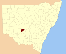 Location in New South Wales | |||||||||||||||
| |||||||||||||||
Franklin County was named in honour of the Arctic explorer, Rear Admiral, and Lieutenant-Governor Sir John Franklin (1786-1847).[1]
Parishes within this county
A full list of parishes found within this county; their current LGA and mapping coordinates to the approximate centre of each location is as follows:
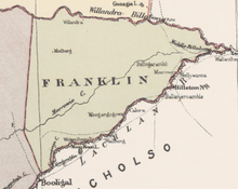
Map of Franklin County from John Sands 1886 map.[2]
| Parish | LGA | Coordinates |
|---|---|---|
| Audrey | Carrathool Shire Council | 33°31′11″S 144°56′52″E |
| Baeda | Carrathool Shire Council | 33°26′45″S 145°12′39″E |
| Bellatherie | Carrathool Shire Council | 33°19′35″S 145°22′44″E |
| Beremagaa | Carrathool Shire Council | 33°14′05″S 145°24′48″E |
| Bundunglong | Carrathool Shire Council | 33°12′44″S 145°06′36″E |
| Caaba | Carrathool Shire Council | 33°39′40″S 145°08′06″E |
| Clutha | Carrathool Shire Council | 33°38′10″S 145°00′02″E |
| Embagga | Carrathool Shire Council | 33°25′04″S 145°28′19″E |
| Florabel | Carrathool Shire Council | 33°28′12″S 145°16′28″E |
| Golgothrie | Carrathool Shire Council | 33°33′09″S 145°01′40″E |
| Gonowlia | Carrathool Shire Council | 33°21′05″S 145°36′11″E |
| Goolagunni | Carrathool Shire Council | 33°14′52″S 145°34′17″E |
| Hadyn | Carrathool Shire Council | 33°25′21″S 145°22′27″E |
| Ideraway | Carrathool Shire Council | 33°41′13″S 144°56′40″E |
| Ini | Carrathool Shire Council | 33°36′52″S 145°15′57″E |
| Kendal | Carrathool Shire Council | 33°25′26″S 145°07′54″E |
| kirindi | Carrathool Shire Council | 33°33′40″S 144°52′05″E |
| Kongong | Carrathool Shire Council | 33°19′10″S 145°29′02″E |
| Lalla | Carrathool Shire Council | 33°21′51″S 144°52′46″E |
| Marowie | Carrathool Shire Council | 33°27′20″S 145°29′04″E |
| Merungle | Carrathool Shire Council | 33°36′09″S 144°55′36″E |
| Merv | Carrathool Shire Council | 33°21′41″S 145°18′39″E |
| Molesworth | Carrathool Shire Council | unknown |
| Moolborg | Carrathool Shire Council | 33°20′58″S 144°58′13″E |
| Myamyn | Carrathool Shire Council | 33°22′57″S 145°03′38″E |
| Narralin | Carrathool Shire Council | 33°18′59″S 145°38′49″E |
| Nellywanna | Carrathool Shire Council | 33°25′27″S 145°31′48″E |
| Papekura | Carrathool Shire Council | 33°12′28″S 145°00′27″E |
| Poli | Carrathool Shire Council | 33°28′57″S 145°01′24″E |
| Roeta | Carrathool Shire Council | 33°17′27″S 144°57′59″E |
| Saburra | Carrathool Shire Council | 33°35′32″S 145°06′43″E |
| Terry | Carrathool Shire Council | 33°14′43″S 145°29′47″E |
| Thononga | Hay Shire Council | 33°46′21″S 144°54′03″E |
| Tooloor | Carrathool Shire Council | 33°15′19″S 145°18′52″E |
| Urugalah | Carrathool Shire Council | 33°17′26″S 145°14′47″E |
| Vieta parish | Carrathool Shire Council | 33°27′34″S 145°05′58″E |
| Warragoodinia | Carrathool Shire Council | 33°22′17″S 145°22′53″E |
| Wheelbah | Carrathool Shire Council | 33°39′32″S 145°13′12″E |
| Wirringa | Carrathool Shire Council | 33°12′58″S 144°54′57″E |
| Wogonga | Carrathool Shire Council | 33°30′45″S 145°18′57″E |
| Wyadra | Carrathool Shire Council | 33°30′06″S 145°24′36″E |
| Wyuna | Carrathool Shire Council | 33°16′15″S 145°06′49″E |
| Yandembah | Carrathool Shire Council | 33°29′56″S 144°52′43″E |
| Yaree | Carrathool Shire Council | 33°13′36″S 145°12′40″E |
gollark: Exorcise, which is like delete but better. String metatable bug reimplementation. About five kinds of Lorem Ipsum available.
gollark: A dedicated licenses viewer. Potatoplex. The ability to view the source of any function in it!
gollark: Stack traces! Lolcrypt!
gollark: And node.lua, and 5rot26 encryption program, and a Windows Registry equivalent.
gollark: Also a Haskell online interpreter frontend.
References
- "Franklin County". Geographical Names Register (GNR) of NSW. Geographical Names Board of New South Wales.

- from John Sands, Atlas of Australia 1886.
This article is issued from Wikipedia. The text is licensed under Creative Commons - Attribution - Sharealike. Additional terms may apply for the media files.